
Owner's Manual
Page 3
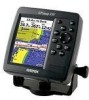
... using the pages. This manual is CANet compatible. GPSMAP 392/398/492/498 Owner's Manual INTRODUCTION > ABOUT THIS MANUAL The Basic Operation section provides you with the GPSMAP 392/398/492/498, review the installation instructions listed in the GPSMAP 392/398/492/498 and step-by -step directions for choosing the Garmin® GPSMAP® 392/398/492/498. The Main Pages...
... using the pages. This manual is CANet compatible. GPSMAP 392/398/492/498 Owner's Manual INTRODUCTION > ABOUT THIS MANUAL The Basic Operation section provides you with the GPSMAP 392/398/492/498, review the installation instructions listed in the GPSMAP 392/398/492/498 and step-by -step directions for choosing the Garmin® GPSMAP® 392/398/492/498. The Main Pages...
Owner's Manual
Page 4
INTRODUCTION > TABLE OF CONTENTS Table of Contents Introduction i About This Manual i Manual Conventions i Warning iv Caution v Care Information vi Basic Operation 1 Initializing the Receiver 1 Simulator Mode 3 Adjusting the Backlight 4 Interface Keys 5 Entering Data and Selecting Options 6 Using ...Pages 26 Map Page 27 Compass Page 32 3D Highway Page 33 Active Route Page 36 Main Menu 37 GPS Tab 37 Tide Tab 40 Trip Tab 44 Celes (Celestial) Tab 45 Points Tab 46 Route Tab ... Tab 64 Sonar Tab 64 Systm (System) Tab 65 Alarm Tab 70 ii GPSMAP 392/398/492/498 Owner's Manual
INTRODUCTION > TABLE OF CONTENTS Table of Contents Introduction i About This Manual i Manual Conventions i Warning iv Caution v Care Information vi Basic Operation 1 Initializing the Receiver 1 Simulator Mode 3 Adjusting the Backlight 4 Interface Keys 5 Entering Data and Selecting Options 6 Using ...Pages 26 Map Page 27 Compass Page 32 3D Highway Page 33 Active Route Page 36 Main Menu 37 GPS Tab 37 Tide Tab 40 Trip Tab 44 Celes (Celestial) Tab 45 Points Tab 46 Route Tab ... Tab 64 Sonar Tab 64 Systm (System) Tab 65 Alarm Tab 70 ii GPSMAP 392/398/492/498 Owner's Manual

Owner's Manual
Page 5
... Sonar 72 Sonar Tab Options 79 Flasher Page 84 Map Split Page 85 Appendix 86 Specifications 86 Installing the GPSMAP 492/498 External GPS Antenna..... 87 Mounting the GPSMAP 392/398/492/498 88 Installing the Transducer 90 Connecting the Power/Data Cable 92 Interfacing 93 Installing and Removing Data Cards 94 Satellite... System 103 Optional Accessories 105 Software License Agreement 106 Product Registration 106 Limited Warranty 107 FCC Compliance 108 Declaration of Conformity (DoC 108 Index 109 GPSMAP 392/398/492/498 Owner's Manual iii
... Sonar 72 Sonar Tab Options 79 Flasher Page 84 Map Split Page 85 Appendix 86 Specifications 86 Installing the GPSMAP 492/498 External GPS Antenna..... 87 Mounting the GPSMAP 392/398/492/498 88 Installing the Transducer 90 Connecting the Power/Data Cable 92 Interfacing 93 Installing and Removing Data Cards 94 Satellite... System 103 Optional Accessories 105 Software License Agreement 106 Product Registration 106 Limited Warranty 107 FCC Compliance 108 Declaration of Conformity (DoC 108 Index 109 GPSMAP 392/398/492/498 Owner's Manual iii
Owner's Manual
Page 6
...accordance with California's Proposition 65. When navigating, carefully compare information displayed on the GPSMAP 392/398/492/498 to navigate safely. Use the electronic chart in the GPSMAP 392/398/492/498 only to facilitate, not to replace, the use of California to cause ...of authorized government charts. This Notice is being provided in death or serious injury. iv GPSMAP 392/398/492/498 Owner's Manual Official government charts and notices to mariners contain all information needed to all available navigation sources, including information from visual sightings, and ...
...accordance with California's Proposition 65. When navigating, carefully compare information displayed on the GPSMAP 392/398/492/498 to navigate safely. Use the electronic chart in the GPSMAP 392/398/492/498 only to facilitate, not to replace, the use of California to cause ...of authorized government charts. This Notice is being provided in death or serious injury. iv GPSMAP 392/398/492/498 Owner's Manual Official government charts and notices to mariners contain all information needed to all available navigation sources, including information from visual sightings, and ...
Owner's Manual
Page 7
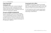
...PRODUCT MAY CONTAIN MERCURY AND MUST BE RECYCLED OR DISPOSED OF ACCORDING TO LOCAL, STATE, OR FEDERAL LAWS. GPSMAP 392/398/492/498 Owner's Manual v The Global Positioning System (GPS) is operated by the United States government, which is subject to changes which could affect the accuracy and ...requires the recycling of direction, distance, location, or topography. Map Data Information: One of the goals of Garmin is to us at a reasonable cost. Use the GPSMAP 392/398/492/498 only as a navigational aid. Caution INTRODUCTION > CAUTIONS Failure to this product, see www.erecycle.org....
...PRODUCT MAY CONTAIN MERCURY AND MUST BE RECYCLED OR DISPOSED OF ACCORDING TO LOCAL, STATE, OR FEDERAL LAWS. GPSMAP 392/398/492/498 Owner's Manual v The Global Positioning System (GPS) is operated by the United States government, which is subject to changes which could affect the accuracy and ...requires the recycling of direction, distance, location, or topography. Map Data Information: One of the goals of Garmin is to us at a reasonable cost. Use the GPSMAP 392/398/492/498 only as a navigational aid. Caution INTRODUCTION > CAUTIONS Failure to this product, see www.erecycle.org....
Owner's Manual
Page 8
... be remedied using a cloth dampened with a mild detergent solution and then wipe dry. at 800/800-1020 or Garmin Europe at 44/0870-8501241. vi GPSMAP 392/398/492/498 Owner's Manual It can cause damage to the unit. Avoid chemical cleaners and solvents that cannot be certain to wipe and air ...dry the unit before reuse. Storing the GPSMAP 392/398/492/498 Do not store the GPSMAP 392/398/492/498 where prolonged exposure...
... be remedied using a cloth dampened with a mild detergent solution and then wipe dry. at 800/800-1020 or Garmin Europe at 44/0870-8501241. vi GPSMAP 392/398/492/498 Owner's Manual It can cause damage to the unit. Avoid chemical cleaners and solvents that cannot be certain to wipe and air ...dry the unit before reuse. Storing the GPSMAP 392/398/492/498 Do not store the GPSMAP 392/398/492/498 where prolonged exposure...

Owner's Manual
Page 9
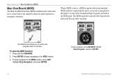
..., release the POWER key. 1 When the screen is complete, press ENTER to agree and acknowledge the warning. The GPS Information Page appears as the receiver begins acquiring satellites. Press ENTER to answer NO to the window asking "Do you press either ENTER or QUIT. To...start the unit. BASIC OPERATION Initializing the Receiver The first time you initialize, make sure the GPSMAP 392/398/492/498 unit and antenna are only asked this the first time you press ENTER to acknowledge the Warning Page. GPSMAP 392/398/492/498 Owner's Manual BASIC OPERATION > INITIALIZING THE...
..., release the POWER key. 1 When the screen is complete, press ENTER to agree and acknowledge the warning. The GPS Information Page appears as the receiver begins acquiring satellites. Press ENTER to answer NO to the window asking "Do you press either ENTER or QUIT. To...start the unit. BASIC OPERATION Initializing the Receiver The first time you initialize, make sure the GPSMAP 392/398/492/498 unit and antenna are only asked this the first time you press ENTER to acknowledge the Warning Page. GPSMAP 392/398/492/498 Owner's Manual BASIC OPERATION > INITIALIZING THE...
Owner's Manual
Page 10
... not necessary to select your approximate location with the appropriate satellite number under each satellite in view appears on the ROCKER until the GPS tab is ready to your region and should acquire a fix within 200 miles. The Initialize Position Page appears, prompting you ...map pointer. 3. Use the ROCKER to move the map pointer to use . 2 GPSMAP 392/398/492/498 Owner's Manual If the unit shows "Ready for the satellites indicated. • Hollow signal strength bars-the receiver has found the indicated satellite(s) and is collecting data. • Solid signal strength bars...
... not necessary to select your approximate location with the appropriate satellite number under each satellite in view appears on the ROCKER until the GPS tab is ready to your region and should acquire a fix within 200 miles. The Initialize Position Page appears, prompting you ...map pointer. 3. Use the ROCKER to move the map pointer to use . 2 GPSMAP 392/398/492/498 Owner's Manual If the unit shows "Ready for the satellites indicated. • Hollow signal strength bars-the receiver has found the indicated satellite(s) and is collecting data. • Solid signal strength bars...

Owner's Manual
Page 11
... practice. Use the ROCKER to navigate using Simulator Mode. Press QUIT to Simulator Mode, the GPS receiver is set to confirm the Running Simulator message that the GPSMAP 392/398/492/498 does not track satellites in Simulator Mode. Keep in mind that appears at the top...signal strength bars shown are only simulations and do not represent the strength of the main pages. 4. GPSMAP 392/398/492/498 Owner's Manual 3 BASIC OPERATION > SIMULATOR MODE To place the GPSMAP 392/398/492/498 in memory for actual navigation. Use the ROCKER to show the Main Menu. Press and hold...
... practice. Use the ROCKER to navigate using Simulator Mode. Press QUIT to Simulator Mode, the GPS receiver is set to confirm the Running Simulator message that the GPSMAP 392/398/492/498 does not track satellites in Simulator Mode. Keep in mind that appears at the top...signal strength bars shown are only simulations and do not represent the strength of the main pages. 4. GPSMAP 392/398/492/498 Owner's Manual 3 BASIC OPERATION > SIMULATOR MODE To place the GPSMAP 392/398/492/498 in memory for actual navigation. Use the ROCKER to show the Main Menu. Press and hold...
Owner's Manual
Page 12
... increase the speed in Simulator Mode. Press and release the POWER key. If you return to show while in 10 knot/kph/mph increments. GPSMAP 392/398/492/498 Owner's Manual Use the ROCKER to set the track. 6. Press ENTER, and select User Track. 5. Press left or right on the General sub tab. Adjusting...
... increase the speed in Simulator Mode. Press and release the POWER key. If you return to show while in 10 knot/kph/mph increments. GPSMAP 392/398/492/498 Owner's Manual Use the ROCKER to set the track. 6. Press ENTER, and select User Track. 5. Press left or right on the General sub tab. Adjusting...
Owner's Manual
Page 13
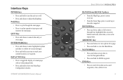
.... • Press and release to adjust backlighting. QUIT Key • Press and release to mark your current location as user waypoints, cities, and services. 5 GPSMAP 392/398/492/498 Owner's Manual ��� ���� ��� ��� ���� ���� ��...
.... • Press and release to adjust backlighting. QUIT Key • Press and release to mark your current location as user waypoints, cities, and services. 5 GPSMAP 392/398/492/498 Owner's Manual ��� ���� ��� ��� ���� ���� ��...
Owner's Manual
Page 14
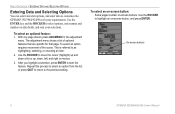
... selecting, or choosing an item. 2. To select an on-screen button: Some pages contain on -screen button, and press ENTER. On-screen buttons 6 GPSMAP 392/398/492/498 Owner's Manual With any page shown, press ADJ/MENU for that are specific for the adjustment menu. To select an optional feature: 1. Use the ENTER.... 3. BASIC OPERATION > ENTERING DATA AND SELECTING OPTIONS Entering Data and Selecting Options You can select and start options, and enter data to customize the GPSMAP 392/398/492/498 to fit your selections. Use the ROCKER to the previous setting.
... selecting, or choosing an item. 2. To select an on-screen button: Some pages contain on -screen button, and press ENTER. On-screen buttons 6 GPSMAP 392/398/492/498 Owner's Manual With any page shown, press ADJ/MENU for that are specific for the adjustment menu. To select an optional feature: 1. Use the ENTER.... 3. BASIC OPERATION > ENTERING DATA AND SELECTING OPTIONS Entering Data and Selecting Options You can select and start options, and enter data to customize the GPSMAP 392/398/492/498 to fit your selections. Use the ROCKER to the previous setting.
Owner's Manual
Page 15
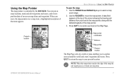
You can pan to map locations, mark and edit waypoints and routes, and review position data of on the Map Page. GPSMAP 392/398/492/498 Owner's Manual 7 Press QUIT to return the map to the map pointer, along with the latitude/longitude of the screen showing the bearing and distance from your ...
You can pan to map locations, mark and edit waypoints and routes, and review position data of on the Map Page. GPSMAP 392/398/492/498 Owner's Manual 7 Press QUIT to return the map to the map pointer, along with the latitude/longitude of the screen showing the bearing and distance from your ...
Owner's Manual
Page 16
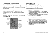
...comments, depth, and water temp, available for each waypoint. Use the ROCKER to highlight the new symbol, and press ENTER/MARK. 8 GPSMAP 392/398/492/498 Owner's Manual Press and hold ENTER/MARK until the New Waypoint window appears. You can enter a new waypoint's location coordinates... manually. A default four-digit name and symbol are created for the name. 4. To enter a different name, highlight the name field, ...
...comments, depth, and water temp, available for each waypoint. Use the ROCKER to highlight the new symbol, and press ENTER/MARK. 8 GPSMAP 392/398/492/498 Owner's Manual Press and hold ENTER/MARK until the New Waypoint window appears. You can enter a new waypoint's location coordinates... manually. A default four-digit name and symbol are created for the name. 4. To enter a different name, highlight the name field, ...
Owner's Manual
Page 17
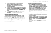
..., a description of the point, its distance and bearing from the Map Page. Highlight OK, and press ENTER/MARK to capture the map pointer location. GPSMAP 392/398/492/498 Owner's Manual 9 To mark a map location or map item, select the location or item with the default name and symbol, press ENTER/MARK. 5. Use the...
..., a description of the point, its distance and bearing from the Map Page. Highlight OK, and press ENTER/MARK to capture the map pointer location. GPSMAP 392/398/492/498 Owner's Manual 9 To mark a map location or map item, select the location or item with the default name and symbol, press ENTER/MARK. 5. Use the...
Owner's Manual
Page 18
... the unit is stored in the waypoint list and works like any of the Navigation Pages to guide you to quickly start the MOB function: 1. GPSMAP 392/398/492/498 Owner's Manual To start navigation back to the MOB location. 3.
... the unit is stored in the waypoint list and works like any of the Navigation Pages to guide you to quickly start the MOB function: 1. GPSMAP 392/398/492/498 Owner's Manual To start navigation back to the MOB location. 3.
Owner's Manual
Page 19
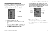
... using the Waypoint Edit Page. The Waypoint Edit Page is available for the selected waypoint. When finished, highlight Next, and press ENTER to cancel. GPSMAP 392/398/492/498 Owner's Manual 11 Reviewing and Editing Waypoints You can review, modify, rename, move, or delete waypoints at any stored waypoint.
... using the Waypoint Edit Page. The Waypoint Edit Page is available for the selected waypoint. When finished, highlight Next, and press ENTER to cancel. GPSMAP 392/398/492/498 Owner's Manual 11 Reviewing and Editing Waypoints You can review, modify, rename, move, or delete waypoints at any stored waypoint.
Owner's Manual
Page 20
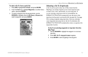
... actively navigating, the Map Page shows a straight line from your current location to the left of points or graphically from the Map Page. 12 GPSMAP 392/398/492/498 Owner's Manual BASIC OPERATION > NAVIGATING TO A DESTINATION To change the Comment, Location, Coordinates, Depth, or Water Temp: 1. To change the waypoint symbol: 1. When you to...
... actively navigating, the Map Page shows a straight line from your current location to the left of points or graphically from the Map Page. 12 GPSMAP 392/398/492/498 Owner's Manual BASIC OPERATION > NAVIGATING TO A DESTINATION To change the Comment, Location, Coordinates, Depth, or Water Temp: 1. To change the waypoint symbol: 1. When you to...
Owner's Manual
Page 21
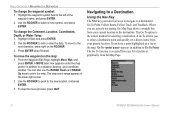
...map item. 2. To Go To an existing waypoint or map item from the waypoint lists, use the ROCKER to the waypoint. Press NAV. GPSMAP 392/398/492/498 Owner's Manual 13 To start navigating to highlight either the By Name or Nearest tab, select a waypoint, and press ENTER. From the Find menu, ...3. See page 8 for creating waypoints using map items. If you are selecting a new map point (non-map item) as the Go To destination, the GPSMAP 392/398/492/498 automatically uses the name of three items from a point list: 1. If you are selecting a map item as the Go To destination, the...
...map item. 2. To Go To an existing waypoint or map item from the waypoint lists, use the ROCKER to the waypoint. Press NAV. GPSMAP 392/398/492/498 Owner's Manual 13 To start navigating to highlight either the By Name or Nearest tab, select a waypoint, and press ENTER. From the Find menu, ...3. See page 8 for creating waypoints using map items. If you are selecting a new map point (non-map item) as the Go To destination, the GPSMAP 392/398/492/498 automatically uses the name of three items from a point list: 1. If you are selecting a map item as the Go To destination, the...

Owner's Manual
Page 22
... using the track log automatically stored in the receiver's memory. Use the ROCKER to move the map pointer to 300 turns and activating an inverted route along the way. TracBack Navigation (Navigating a Track) The TracBack function retraces your current trip. 14 GPSMAP 392/398/492/498 Owner's Manual BASIC OPERATION > NAVIGATING TO A DESTINATION To Go...
... using the track log automatically stored in the receiver's memory. Use the ROCKER to move the map pointer to 300 turns and activating an inverted route along the way. TracBack Navigation (Navigating a Track) The TracBack function retraces your current trip. 14 GPSMAP 392/398/492/498 Owner's Manual BASIC OPERATION > NAVIGATING TO A DESTINATION To Go...


