
Owner's Manual
Page 23
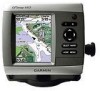
...Waypoints & Tracks, Other Vessels, and Data Bars, see "Navigation Chart Menu" on or off . (The Weather feature is only available if the chartplotter is highlighted. 2. Blue indicates deep water, yellow is shallow water, and red is displayed over the navaid, the navaid is connected to the ...The Off setting shows the land as beacons, lights, and obstructions: 1. The On setting indicates shallow water and land with a color scale. Mariner's Eye 3D (Water Hazard Colors) GPSMAP 400/500 Series Owner's Manual 17 Press the Range (-) key to move the view closer to your boat and lower to a...
...Waypoints & Tracks, Other Vessels, and Data Bars, see "Navigation Chart Menu" on or off . (The Weather feature is only available if the chartplotter is highlighted. 2. Blue indicates deep water, yellow is shallow water, and red is displayed over the navaid, the navaid is connected to the ...The Off setting shows the land as beacons, lights, and obstructions: 1. The On setting indicates shallow water and land with a color scale. Mariner's Eye 3D (Water Hazard Colors) GPSMAP 400/500 Series Owner's Manual 17 Press the Range (-) key to move the view closer to your boat and lower to a...
Owner's Manual
Page 47
...GPSMAP 400/500 Series Owner's Manual Configuring the Chartplotter (in Europe) on or off . WAAS/EGNOS can provide more-accurate GPS position information. The speed filter averages the speed of time for depth, temperature, distance, speed, elevation, volume, and pressure. 41 Configuring System Settings To change units of system events. A Garmin...kh, m, ºC), Nautical (kt, ft, ºF), or Custom. Select Display > Color Mode to configure unit settings. When On is selected, the chartplotter will automatically turn on or off . However, when using WAAS or EGNOS, the device ...
...GPSMAP 400/500 Series Owner's Manual Configuring the Chartplotter (in Europe) on or off . WAAS/EGNOS can provide more-accurate GPS position information. The speed filter averages the speed of time for depth, temperature, distance, speed, elevation, volume, and pressure. 41 Configuring System Settings To change units of system events. A Garmin...kh, m, ºC), Nautical (kt, ft, ºF), or Custom. Select Display > Color Mode to configure unit settings. When On is selected, the chartplotter will automatically turn on or off . However, when using WAAS or EGNOS, the device ...

Owner's Manual
Page 62
... routine call . If your Garmin chartplotter and VHF radio are using a Garmin NMEA 2000compatible VHF radio. •...Rocker to a DSC contact from the chartplotter. Receiving Distress Calls If your radio is ...receives a DSC distress call from the same boat, it on or off : 1. From a chart screen, press MENU > Other Vessels > DSC > DSC List. Select Clear Report to call . 56 GPSMAP...received from a boat. Select Configure > Other Vessels. 2. While viewing a chart, press MENU > Other Vessels > DSC > DSC List > Add Contact. 2. Select Review to set up to change the line color...
... routine call . If your Garmin chartplotter and VHF radio are using a Garmin NMEA 2000compatible VHF radio. •...Rocker to a DSC contact from the chartplotter. Receiving Distress Calls If your radio is ...receives a DSC distress call from the same boat, it on or off : 1. From a chart screen, press MENU > Other Vessels > DSC > DSC List. Select Clear Report to call . 56 GPSMAP...received from a boat. Select Configure > Other Vessels. 2. While viewing a chart, press MENU > Other Vessels > DSC > DSC List > Add Contact. 2. Select Review to set up to change the line color...
Owner's Manual
Page 63
...color. From the Home screen, select Information > Other Vessels > DSC List. 2. For information on placing distress calls from your Garmin radio, see page 29. GPSMAP 400/500 Series Owner's Manual Using Digital Selective Calling Position Tracking When you connect your Garmin chartplotter to a VHF radio using a Garmin... reports. Man-Overboard Distress Calls Initiated from a VHF Radio When your Garmin chartplotter is connected to a Garmin NMEA 2000-compatible radio and you initiate a man-overboard DSC distress call received is logged in the DSC list (page 40). DSC Call Information). ...
...color. From the Home screen, select Information > Other Vessels > DSC List. 2. For information on placing distress calls from your Garmin radio, see page 29. GPSMAP 400/500 Series Owner's Manual Using Digital Selective Calling Position Tracking When you connect your Garmin chartplotter to a VHF radio using a Garmin... reports. Man-Overboard Distress Calls Initiated from a VHF Radio When your Garmin chartplotter is connected to a Garmin NMEA 2000-compatible radio and you initiate a man-overboard DSC distress call received is logged in the DSC list (page 40). DSC Call Information). ...
Owner's Manual
Page 64
... transmits this request with the position report (page 10). Placing an Individual Routine Call When you connect your Garmin chartplotter to a Garmin VHF NMEA 2000-compatible radio, you can use the chartplotter interface to set the duration of the vessel, and a Blue Flag symbol indicating the last reported position. ...8226; Select Navigate To to Go To or Route To the location sent with your call. 58 GPSMAP 400/500 Series Owner's Manual Select Trail. To change the symbol and color of the following channels on the Navigation chart. To turn trails off for a specific vessel that ...
... transmits this request with the position report (page 10). Placing an Individual Routine Call When you connect your Garmin chartplotter to a Garmin VHF NMEA 2000-compatible radio, you can use the chartplotter interface to set the duration of the vessel, and a Blue Flag symbol indicating the last reported position. ...8226; Select Navigate To to Go To or Route To the location sent with your call. 58 GPSMAP 400/500 Series Owner's Manual Select Trail. To change the symbol and color of the following channels on the Navigation chart. To turn trails off for a specific vessel that ...


