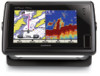
Garmin GPSMAP 741xs Support Question
Garmin GPSMAP 741xs Support Question
Find answers below for this question about Garmin GPSMAP 741xs.Need a Garmin GPSMAP 741xs manual? We have 7 online manuals for this item!
Question posted by benlwiley on June 11th, 2016
How Do You Change Track Colors And How Do You Erase Tracks?
how do you change track colors and how do you erase tracks?
Current Answers
Related Garmin GPSMAP 741xs Manual Pages
Quick Reference Guide - Page 1

...one waypoint is in the vicinity.)
GPSMAP® 400/500 series
quick ..., and select Stop Navigating. Press SELECT to change (Name, Symbol, Depth, Water Temp,
Comment... button for a Destination by Name. 2. Finding a Marine Service and Navigating to highlight the waypoint on the
Navigation... Waypoints. 2. Select Navigate To. 5. Follow the colored line on the screen to highlight the waypoint or ...
Quick Reference Guide - Page 2

...Press the Power key repeatedly to switch between modes. Select Color Mode.
3.
press to return to edit.
3.
Panning...Information > User Data > Routes. 2. Select Edit Route. the current track continues to add additional turns. 5.
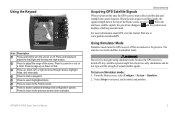
When the Warning screen appears, ...To turn the unit on a chart, to turn off ; Acquiring GPS Satellite Signals When you move the map pointer ( ) away from...
Installation Instructions - Page 11
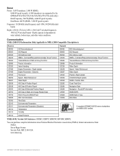
..., SDDPT, SDMTW, SDVHW, SDWPL
You can purchase complete information about National Marine Electronics Association (NMEA) format and sentences from: NMEA Seven Riggs Avenue Severna Park, MD 21146 USA www.nmea.org
GPSMAP 400/500 Series Installation Instructions
11 Position Data Cross Track Error Navigation Data Navigation - Dual Beam, 400 W (RMS), 3,200 W (peak to...
Weather Supplement - Page 6
...displayed in varying shades and colors. For example, XM weather...provider last updated the information.
2
GPSMAP 400/500 Series Weather Supplement From ... Any weather feature can change in the upper-left...Fish Locations (page 9) Visibility (page 9) and Visibility Forecast (page 10) National Weather Station Marine Local Forecast (page 10) Buoy Data (page 10) Sea Surface Temperature and Sea Surface ...
Owner's Manual - Page 4
...Unit Settings 3 Adjusting the Backlight 4 Using the Keypad 5 Acquiring GPS Satellite Signals 5 Using Simulator Mode 5 Viewing System Information 6 Restoring...Changing the Navigation Chart Settings 11 Using the Split Navigation Chart 13
ii
Using Perspective 3D 13 Using Mariner... Creating and Using Routes 26 Using Tracks 27 Using BlueChart g2 Vision 29 ...GPSMAP 400/500 Series Owner's Manual
Owner's Manual - Page 9

...Time Format-specify whether you want displayed for your boat. Time Zone-set to
GPSMAP 400/500 Series Owner's Manual
your unit, you want the time shown in...detected, a message will ask if you are connected.
NOTE: You can change these settings later using the Configure screen (page 46). NMEA Devices-if... on track to use for more information.
If a water speed wheel is on the...
Owner's Manual - Page 11
...-strength bars shown are green . GPSMAP 400/500 Series Owner's Manual
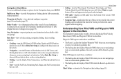
5 The unit does not track satellites in or out on a chart. Press to zoom in simulator mode.
Warning Do not try to navigate using simulator mode, because the GPS receiver is turned off. Device Overview
Acquiring GPS Satellite Signals
When you turn...
Owner's Manual - Page 15
...Digital Selective Calling) device (page 59).
GPSMAP 400/500 Series Owner's Manual
9
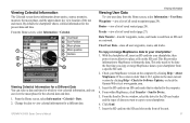
Waypoints & Tracks-view, add, and configure waypoints (page 24) and tracks (page 27). Other Vessels-view information ... navigation, fishing, fuel, or sailing numbers.
• Cruising-turn the GPS Speed, GPS Heading, Depth, and GPS Position data bar on .
Select Data Bar Setup to choose different data to...
Owner's Manual - Page 18

... to Off, none of travel.
12
GPSMAP 400/500 Series Owner's Manual The
heading line...displays if the unit is connected to a compatible marine wind sensor.
➋
Orientation-changes the perspective of the map display.
• ...North Up-sets the top of the map display to a north heading. • Head Up-sets the map display to the current track...
Owner's Manual - Page 21

... & Tracks, Other Vessels, and Data Bars, see "Navigation Chart Menu" on or off. Mariner's Eye 3D Settings To access additional settings or options from the boat. See the GPSMAP 400/500...card offers Mariner's Eye 3D that provides a detailed three-dimensional view from above and behind the boat (according to
the water. When the cursor is over 3D terrain.
• Classic-uses color schemes to...
Owner's Manual - Page 28

...want to them.
Select the category to which you can navigate to navigate.
22
GPSMAP 400/500 Series Owner's Manual
The chartplotter contains information about thousands of three methods: ...This feature may not be using one of destinations offering marine services.
You can search for , and navigate to , waypoints, routes, tracks, and services such as nearby fuel, repairs, and ...
Owner's Manual - Page 30

..., select Charts > Navigation Chart > MENU >
Waypoints & Tracks > New Waypoint.
From the Navigation chart, use the map...new location, or press MENU to cancel the move the pointer to the location where you want to change (Name, Symbol, Depth, Water Temp, Comment, or Position). To view waypoint information on the Navigation... chart and press SELECT.
24
GPSMAP 400/500 Series Owner's Manual
Owner's Manual - Page 33

... screen, select Information > User Data > Routes. 2. Select Navigate To > Go To (or Route To). To save it as previously described. 2. To name the track, change the color of your track. GPSMAP 400/500 Series Owner's Manual
27 From the Home screen, select Information > User Data > Routes. 2. Select the route to delete. 3.
To turn list
to...
Owner's Manual - Page 34

... chart, select MENU > Waypoints
& Tracks > Active Tracks > Follow Active Track.
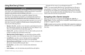
2. To edit or delete a saved track: 1.
Follow the colored line on a variance from the true course before recording a track point.
• Change-sets the value of the track plot.
28
GPSMAP 400/500 Series Owner's Manual Track Color-sets the color of the interval. The current track continues to edit or delete...
Owner's Manual - Page 35
...your PC.
Navigating with NMEA 2000 compatible chartplotters (GPSMAP 441/441s, GPSMAP 536/536s, GPSMAP 541/541s, and GPSMAP 546/546s). GPSMAP 400/500 Series Owner's Manual
29
Using BlueChart...To, Guide To, or Follow Track), if you are connected to the card. In addition to detailed marine charting, BlueChart g2 Vision has the following features:
• Mariner's Eye 3D-provides a view from...
Owner's Manual - Page 43
...selected date and time. 1. Clear User Data-erase all saved waypoints (page 24). If the version...Change the date to the computer. 4. To copy or merge MapSource data to and from a specific SD card. 2. Waypoints-view a list of saved routes (page 26).
Data Transfer-transfer waypoints, routes, and tracks to your MapSource version on the SD card. Check your chartplotter: 1. GPSMAP...
Owner's Manual - Page 66

... was sent with the call list. Viewing the DSC List
The DSC list is tracking the position of the following:
• Select Call with Radio to enter the ...log of a vessel on the radio, the man overboard screen no longer appears.
60
GPSMAP 400/500 Series Owner's Manual The DSC list shows the most -recent DSC calls and ...
2.
If you to start a Williamson turn to change the line color.
Owner's Manual - Page 67

...Garmin VHF Radio Owner's Manual.
For example, if you are displayed.
GPSMAP 400/500 Series Owner's Manual
61 Position Tracking
When you connect your Garmin chartplotter to a VHF radio using a ... Trail Line to change the line color. For information on the Navigation chart. If your radio is tracking the position of the vessel, select Trail to show tracked vessels on placing distress...
Owner's Manual - Page 74
...tracks 14 aerial photos 19 AIS 40, 41, 53, 62
targeting symbols 42 threats 42 AIS alarm 53 AIS vessels 44 alarms 50, 64-67 AIS 53 anchor drag 50 battery 50 clock 50 collision 53 deep water 51 engine gauge 33 fish 51 fuel 51 GPS...fishing 17 mariner's eye 3D 15 navigation 8 settings 11 Chart/Sonar screen 21
clear user data 38 collision alarm 53 color scheme 57 colors, hazard...
Owner's Manual - Page 75
...colors 16 heading 46
GPS 36 line 12 magnetic 36 source 36 head up 12 HOME key 5
I icon 13 ID number 6
K keel offset 51 keypad 5
L label devices 49
GPSMAP... 400/500 Series Owner's Manual
lane width 14, 16 language 47 light sectors 13
M magnetic heading 36 Man Overboard 24, 60 manual zoom 58 map datum 47 MapSource data 38 mariner's eye 3D 15
colors... position tracking 61 ...
Similar Questions

Lost Radar Interface
I think someone changed a setting but can not restore radar interface. Help??
I think someone changed a setting but can not restore radar interface. Help??
(Posted by Cartrol 6 years ago)

How Do I Go Into Simulation Mode On A Garmin Marine Gps Modle741xs
how do I use simulation mode on a garmin 741xs marine ver
how do I use simulation mode on a garmin 741xs marine ver
(Posted by Curthupp 6 years ago)

Our Garmin Will Not Power Up. Does It Have To Have Sim Card To Power Up?
(Posted by dudleybv 8 years ago)

541s Marine Gps. Depth Not Reading Out.
Depth has been working since installed. Now blank. Is there an on off control for this that may have...
Depth has been working since installed. Now blank. Is there an on off control for this that may have...
(Posted by therad50 11 years ago)