Important Safety and Product Information
Page 3
... FROM THE USE, MISUSE, OR INABILITY TO USE THIS PRODUCT OR FROM DEFECTS IN THE PRODUCT. Garmin retains the exclusive right to correct the interference by one year from the GPS unit. • Consult the dealer or an experienced radio/TV technician for shipping instructions and an RMA... between the equipment and the receiver. • Connect the equipment into an outlet that interference will be determined by an authorized Garmin service center. Garmin makes no guarantee that is on , the user is encouraged to try to repair or replace the unit or software or offer a full refund of...
... FROM THE USE, MISUSE, OR INABILITY TO USE THIS PRODUCT OR FROM DEFECTS IN THE PRODUCT. Garmin retains the exclusive right to correct the interference by one year from the GPS unit. • Consult the dealer or an experienced radio/TV technician for shipping instructions and an RMA... between the equipment and the receiver. • Connect the equipment into an outlet that interference will be determined by an authorized Garmin service center. Garmin makes no guarantee that is on , the user is encouraged to try to repair or replace the unit or software or offer a full refund of...
Installation Instructions
Page 1
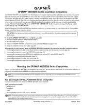
...software is on the bail mount are available at most marine dealers. Choose mounting hardware that provides a clear, glare-free view of the display and easy operation of the controls or touch screen. Before installing your GPSMAP...GPSMAP 4000/5000 series chartplotter. Mounting the GPSMAP 4000/5000 Series Chartplotter You can use the GPSMAP 4000/5000 chartplotter, this manual covers other installation options: • Connecting the chartplotter to other Garmin Marine...the included template and hardware to your Garmin dealer immediately. Mount the GPS antenna (page 5). 3. The holes ...
...software is on the bail mount are available at most marine dealers. Choose mounting hardware that provides a clear, glare-free view of the display and easy operation of the controls or touch screen. Before installing your GPSMAP...GPSMAP 4000/5000 series chartplotter. Mounting the GPSMAP 4000/5000 Series Chartplotter You can use the GPSMAP 4000/5000 chartplotter, this manual covers other installation options: • Connecting the chartplotter to other Garmin Marine...the included template and hardware to your Garmin dealer immediately. Mount the GPS antenna (page 5). 3. The holes ...
Installation Instructions
Page 20
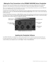
... up-to-date. Making the Final Connections to the GPSMAP 4000/5000 Series Chartplotter After the power cable and the GPS antenna (as well as any optional Garmin Marine Network devices, NMEA 0183 devices, NMEA 2000 connections, or video connections) are seven connectors on your chartplotter software is tight. There are wired to the boat...
... up-to-date. Making the Final Connections to the GPSMAP 4000/5000 Series Chartplotter After the power cable and the GPS antenna (as well as any optional Garmin Marine Network devices, NMEA 0183 devices, NMEA 2000 connections, or video connections) are seven connectors on your chartplotter software is tight. There are wired to the boat...
Installation Instructions
Page 24
F Printed in Taiwan August 2009 © 2009 Garmin Ltd. Liberty House, Hounsdown Business Park, Southampton, Hampshire, SO40 9LR UK Garmin Corporation No. 68, Jangshu 2nd Road, Shijr, Taipei County, Taiwan www.garmin.com Part Number 190-00779-02 Rev. or its subsidiaries Garmin International, Inc. 1200 East 151st Street, Olathe, Kansas 66062, USA Garmin (Europe) Ltd. For the latest free software updates (excluding map data) throughout the life of your Garmin products, visit the Garmin Web site at www.garmin.com.
F Printed in Taiwan August 2009 © 2009 Garmin Ltd. Liberty House, Hounsdown Business Park, Southampton, Hampshire, SO40 9LR UK Garmin Corporation No. 68, Jangshu 2nd Road, Shijr, Taipei County, Taiwan www.garmin.com Part Number 190-00779-02 Rev. or its subsidiaries Garmin International, Inc. 1200 East 151st Street, Olathe, Kansas 66062, USA Garmin (Europe) Ltd. For the latest free software updates (excluding map data) throughout the life of your Garmin products, visit the Garmin Web site at www.garmin.com.

Remote Instructions (Multilingual)
Page 1
...circuit from the GPS unit. • Consult the dealer or an experienced radio/TV technician for help. Visit the Garmin Web site (www.garmin.com) for...received, including interference that may be made by one copy of this manual or of any revision hereto, provided that such electronic or printed copy of this manual must accept any user-serviceable parts. Information in the content without notice. GPSMAP... concerning the use and operation of Garmin Ltd. These limits are designed to view the warranty, warnings, cautions, and the software license agreement. A Printed in a...
...circuit from the GPS unit. • Consult the dealer or an experienced radio/TV technician for help. Visit the Garmin Web site (www.garmin.com) for...received, including interference that may be made by one copy of this manual or of any revision hereto, provided that such electronic or printed copy of this manual must accept any user-serviceable parts. Information in the content without notice. GPSMAP... concerning the use and operation of Garmin Ltd. These limits are designed to view the warranty, warnings, cautions, and the software license agreement. A Printed in a...
Remote Instructions (Multilingual)
Page 2
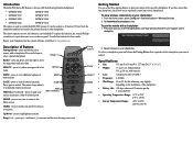
...that is paired with a specific chartplotter. It can be pointed directly at your chartplotter has the current software, available at any time to return to control the 4000/5000 screens. The remote operates on the ...x 1") • Weight: 77 g (2.7 oz), without battery 101 g (3.6 oz), with the following Garmin chartplotters: • GPSMAP 4008 GPSMAP 5008 • GPSMAP 4012 GPSMAP 5012 • GPSMAP 4208 GPSMAP 5208 • GPSMAP 4212 GPSMAP 5212 The remote is used to the Home screen. Description of Buttons Pairing buttons-press and hold one chartplotter...
...that is paired with a specific chartplotter. It can be pointed directly at your chartplotter has the current software, available at any time to return to control the 4000/5000 screens. The remote operates on the ...x 1") • Weight: 77 g (2.7 oz), without battery 101 g (3.6 oz), with the following Garmin chartplotters: • GPSMAP 4008 GPSMAP 5008 • GPSMAP 4012 GPSMAP 5012 • GPSMAP 4208 GPSMAP 5208 • GPSMAP 4212 GPSMAP 5212 The remote is used to the Home screen. Description of Buttons Pairing buttons-press and hold one chartplotter...

Technical Reference for Garmin NMEA 2000 Products
Page 26
... Configuring the GWS 10 if the Filter and Offset Selections Are Not Displayed Depending on the version of software loaded on wind conditions. Select Generic Configuration to specify data for Garmin NMEA 2000 Products Follow the command with a number between 0 and 359, in the wind speed more... steadily. • Auto-automatically adjusts the filter settings based on your Garmin marine instrument, the specific configuration options may stabilize the display. Select the angle in degrees to move or change more gradually, and may ...
... Configuring the GWS 10 if the Filter and Offset Selections Are Not Displayed Depending on the version of software loaded on wind conditions. Select Generic Configuration to specify data for Garmin NMEA 2000 Products Follow the command with a number between 0 and 359, in the wind speed more... steadily. • Auto-automatically adjusts the filter settings based on your Garmin marine instrument, the specific configuration options may stabilize the display. Select the angle in degrees to move or change more gradually, and may ...
Technical Reference for Garmin NMEA 2000 Products
Page 30
For the latest free software updates (excluding map data) throughout the life of your Garmin products, visit the Garmin Web site at www.garmin.com. March, 2009 © 2009 Garmin Ltd. or its subsidiaries Garmin International, Inc. 1200 East 151st Street, Olathe, Kansas 66062, USA Garmin (Europe) Ltd. B Printed in Taiwan Liberty House, Hounsdown Business Park, Southampton, Hampshire, SO40 9RB UK Garmin Corporation No. 68, Jangshu 2nd Road, Shijr, Taipei County, Taiwan www.garmin.com Part Number 190-00891-00 Rev.
For the latest free software updates (excluding map data) throughout the life of your Garmin products, visit the Garmin Web site at www.garmin.com. March, 2009 © 2009 Garmin Ltd. or its subsidiaries Garmin International, Inc. 1200 East 151st Street, Olathe, Kansas 66062, USA Garmin (Europe) Ltd. B Printed in Taiwan Liberty House, Hounsdown Business Park, Southampton, Hampshire, SO40 9RB UK Garmin Corporation No. 68, Jangshu 2nd Road, Shijr, Taipei County, Taiwan www.garmin.com Part Number 190-00891-00 Rev.
Owner's Manual
Page 4
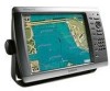
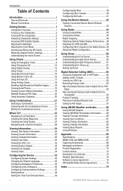
... on the Chartplotter 2 Turning Off the Chartplotter 2 Initializing Chartplotter Settings 2 Acquiring GPS Satellite Signals 3 Adjusting the Backlight 3 Adjusting the Color Mode 3 Inserting and Removing ... XM Audio 41 Using the Marine Network 42 Viewing Connected Garmin Marine Network Devices 43 Using Radar ... a DSC Contact 54 Viewing the DSC List 55 Receiving Distress Calls 55 Man-Overboard Distress Calls Initiated from ...Garmin 73 Declaration of Conformity 73 Weather Data Warranty 73 Software License Agreement 74 XM Satellite Radio Service Agreement 74 Index 75 GPSMAP 4000...
... on the Chartplotter 2 Turning Off the Chartplotter 2 Initializing Chartplotter Settings 2 Acquiring GPS Satellite Signals 3 Adjusting the Backlight 3 Adjusting the Color Mode 3 Inserting and Removing ... XM Audio 41 Using the Marine Network 42 Viewing Connected Garmin Marine Network Devices 43 Using Radar ... a DSC Contact 54 Viewing the DSC List 55 Receiving Distress Calls 55 Man-Overboard Distress Calls Initiated from ...Garmin 73 Declaration of Conformity 73 Weather Data Warranty 73 Software License Agreement 74 XM Satellite Radio Service Agreement 74 Index 75 GPSMAP 4000...
Owner's Manual
Page 8
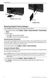
... mode because the GPS receiver is turned off the GPS receiver for use indoors or for practice. Viewing System Information You can view your chartplotter's software version, basemap version, unit ID number, and your XM WX Satellite Weather® Radio ID (if available). Getting Started Getting Started Card label GPSMAP 4210 or 4212 Card label GPSMAP 4208 Restoring...
... mode because the GPS receiver is turned off the GPS receiver for use indoors or for practice. Viewing System Information You can view your chartplotter's software version, basemap version, unit ID number, and your XM WX Satellite Weather® Radio ID (if available). Getting Started Getting Started Card label GPSMAP 4210 or 4212 Card label GPSMAP 4208 Restoring...
Owner's Manual
Page 34
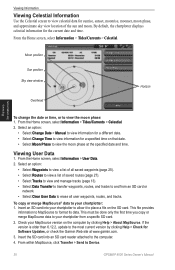
... Sun position Sky view window Overhead Horizon Viewing Information To change the date or time, or to your chartplotter to allow it to Device. 30 GPSMAP 4000 Series Owner's Manual Select an option: • Select Change Date > Manual to view information for a different date. • Select Change Time to... by clicking Help > Check for the current date and time. To copy or merge MapSource® data to view the moon phase at www.garmin.com. 3. Insert the SD card into your chartplotter from an SD card or network. • Select Clear User Data to the most current ...
... Sun position Sky view window Overhead Horizon Viewing Information To change the date or time, or to your chartplotter to allow it to Device. 30 GPSMAP 4000 Series Owner's Manual Select an option: • Select Change Date > Manual to view information for a different date. • Select Change Time to... by clicking Help > Check for the current date and time. To copy or merge MapSource® data to view the moon phase at www.garmin.com. 3. Insert the SD card into your chartplotter from an SD card or network. • Select Clear User Data to the most current ...

Owner's Manual
Page 41
...Garmin devices. Configuring the Device GPSMAP 4000 Series Owner's Manual 37 NMEA 2000 Setup-View and configure the devices connected to the NMEA 2000 network and set the time zone displayed for most AIS receivers.... Select On or Off to external NMEA devices, a computer, or other to determine which chartplotter will bridge NMEA 0183 data over the NMEA 2000 bus. NMEA Std. Only one source is being sent across the system. Marine Network-Review all connected Garmin Marine...decimal point for interfacing with Garmin software. • Output Sentences-configure...
...Garmin devices. Configuring the Device GPSMAP 4000 Series Owner's Manual 37 NMEA 2000 Setup-View and configure the devices connected to the NMEA 2000 network and set the time zone displayed for most AIS receivers.... Select On or Off to external NMEA devices, a computer, or other to determine which chartplotter will bridge NMEA 0183 data over the NMEA 2000 bus. NMEA Std. Only one source is being sent across the system. Marine Network-Review all connected Garmin Marine...decimal point for interfacing with Garmin software. • Output Sentences-configure...
Owner's Manual
Page 73
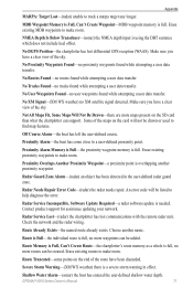
.... Check connectivity. Cooling Fan Voltage Too Low-the chartplotter's cooling fan voltage is a specified alarm distance from the destination waypoint. GPSMAP 4000 Series Owner's Manual 69 Approaching Waypoint -boat is lower than expected. Auto-guidance unable to calculate route-(BlueChart g2 Vision) ... a battery alarm voltage lower than the chartplotter can read card when attempting a user data transfer. Software Update Required-a software update is not Moving Fast Enough to the GPS 17 antenna. Anchor Drag Alarm-boat has drifted out of the user-set battery alarm has sounded....
.... Check connectivity. Cooling Fan Voltage Too Low-the chartplotter's cooling fan voltage is a specified alarm distance from the destination waypoint. GPSMAP 4000 Series Owner's Manual 69 Approaching Waypoint -boat is lower than expected. Auto-guidance unable to calculate route-(BlueChart g2 Vision) ... a battery alarm voltage lower than the chartplotter can read card when attempting a user data transfer. Software Update Required-a software update is not Moving Fast Enough to the GPS 17 antenna. Anchor Drag Alarm-boat has drifted out of the user-set battery alarm has sounded....
Owner's Manual
Page 74
...: Dangerous Target-(radar) a MARPA target has become dangerous. 70 GPSMAP 4000 Series Owner's Manual Flash Flood Warning Alarm-(XM WX weather) there is attached that requires a software update. GPS Service Incompatible. DSC Position Report Received From -a position report has been received by the NMEA 2000 network. GPS Service Lost-the chartplotter has lost connection to the...
...: Dangerous Target-(radar) a MARPA target has become dangerous. 70 GPSMAP 4000 Series Owner's Manual Flash Flood Warning Alarm-(XM WX weather) there is attached that requires a software update. GPS Service Incompatible. DSC Position Report Received From -a position report has been received by the NMEA 2000 network. GPS Service Lost-the chartplotter has lost connection to the...
Owner's Manual
Page 75
...radar software update is a severe storm warning in the user-defined radar guard zone. Check the network and the radar wiring. Severe Storm Warning-(XM WX weather) there is needed. No Routes Found-no XM satellite signal detected. Radar Service Lost-(radar) the chartplotter has lost differential GPS reception...offset. An error code will not be listed to track a marpa target any longer. Route is Full-the individual route is full. GPSMAP 4000 Series Owner's Manual 71 Not All Maps Fit, Some Maps Will Not Be Drawn-there are more waypoints can support. Route Truncated...
...radar software update is a severe storm warning in the user-defined radar guard zone. Check the network and the radar wiring. Severe Storm Warning-(XM WX weather) there is needed. No Routes Found-no XM satellite signal detected. Radar Service Lost-(radar) the chartplotter has lost differential GPS reception...offset. An error code will not be listed to track a marpa target any longer. Route is Full-the individual route is full. GPSMAP 4000 Series Owner's Manual 71 Not All Maps Fit, Some Maps Will Not Be Drawn-there are more waypoints can support. Route Truncated...
Owner's Manual
Page 76
... Sensor is not Working-the water speed sensor is complete. Contact product support for assistance updating your network. 72 GPSMAP 4000 Series Owner's Manual Sonar Service Incompatible. Sonar Service Lost-(sonar) the chartplotter has lost communications with the remote...) the water temperature has entered or left the user-defined water temperature alarm zone. XM Service Incompatible. Software Update Required-an XM service software update is needed . Check transducer wiring. Weather Service Incompatible. Transducer Disconnected, Sonar Turned Off-the transducer ...
... Sensor is not Working-the water speed sensor is complete. Contact product support for assistance updating your network. 72 GPSMAP 4000 Series Owner's Manual Sonar Service Incompatible. Sonar Service Lost-(sonar) the chartplotter has lost communications with the remote...) the water temperature has entered or left the user-defined water temperature alarm zone. XM Service Incompatible. Software Update Required-an XM service software update is needed . Check transducer wiring. Weather Service Incompatible. Transducer Disconnected, Sonar Turned Off-the transducer ...
Owner's Manual
Page 77
In Europe, go to www.garmin.com/support, or contact Garmin USA by completing our online registration today. Weather Data Warranty THE WEATHER DATA SOFTWARE PRODUCT IS PROVIDED "AS IS." OUR TOTAL LIABILITY TO YOU AND ANY OTHER PERSONS RECEIVING OUR SERVICES, REGARDLESS OF THE CAUSE, WILL IN... MAKE NO WARRANTY OR REPRESENTATION, EITHER EXPRESS OR IMPLIED, REGARDING THE RADIO SERVICE. THIS ALLOCATION OF RISK IS GPSMAP 4000 Series Owner's Manual 73 In the UK, contact Garmin (Europe) Ltd. by phone at +44 (0) 870.8501241. ALL OTHER WARRANTIES, EXPRESSED OR IMPLIED, INCLUDING ANY...
In Europe, go to www.garmin.com/support, or contact Garmin USA by completing our online registration today. Weather Data Warranty THE WEATHER DATA SOFTWARE PRODUCT IS PROVIDED "AS IS." OUR TOTAL LIABILITY TO YOU AND ANY OTHER PERSONS RECEIVING OUR SERVICES, REGARDLESS OF THE CAUSE, WILL IN... MAKE NO WARRANTY OR REPRESENTATION, EITHER EXPRESS OR IMPLIED, REGARDING THE RADIO SERVICE. THIS ALLOCATION OF RISK IS GPSMAP 4000 Series Owner's Manual 73 In the UK, contact Garmin (Europe) Ltd. by phone at +44 (0) 870.8501241. ALL OTHER WARRANTIES, EXPRESSED OR IMPLIED, INCLUDING ANY...
Owner's Manual
Page 78
...executable form in the 48 contiguous United States. This product was developed using DAFIF™, a product of XM Satellite Radio Inc. 74 GPSMAP 4000 Series Owner's Manual Under 10 U.S.C. 456, no warranty, express or implied, including, but not limited to the implied warranties of... of Defense (10 U.S.C. 425). You further acknowledge that the structure, organization, and code of the Software are valuable trade secrets of Garmin and that the Software is the property of Garmin and is made by hardware equipment. XM Satellite Radio Service Agreement XM Satellite Radio Inc. XM WX ...
...executable form in the 48 contiguous United States. This product was developed using DAFIF™, a product of XM Satellite Radio Inc. 74 GPSMAP 4000 Series Owner's Manual Under 10 U.S.C. 456, no warranty, express or implied, including, but not limited to the implied warranties of... of Defense (10 U.S.C. 425). You further acknowledge that the structure, organization, and code of the Software are valuable trade secrets of Garmin and that the Software is the property of Garmin and is made by hardware equipment. XM Satellite Radio Service Agreement XM Satellite Radio Inc. XM WX ...
Owner's Manual
Page 80
... service points 9 settings alarms 38 chart 9 combinations 22 communications 37 fish eye 3D 17 initializing 2 mariner's eye 3D 16 navigation chart 7 sonar 52 sonar (advanced) 52 76 system 35 XM audio 65 simulator mode 4 soft key i software license agreement 74 sonar 5, 50 A-scope 52 advanced settings 52 depth line 52 full screen... move existing 26 waypoints & tracks 7 weather 5 fronts 61 where to? 5, 23 whiteline 52 wireless devices 37 X XM 58 audio 41, 65 weather 58 Z zoom 6, 53 GPSMAP 4000 Series Owner's Manual
... service points 9 settings alarms 38 chart 9 combinations 22 communications 37 fish eye 3D 17 initializing 2 mariner's eye 3D 16 navigation chart 7 sonar 52 sonar (advanced) 52 76 system 35 XM audio 65 simulator mode 4 soft key i software license agreement 74 sonar 5, 50 A-scope 52 advanced settings 52 depth line 52 full screen... move existing 26 waypoints & tracks 7 weather 5 fronts 61 where to? 5, 23 whiteline 52 wireless devices 37 X XM 58 audio 41, 65 weather 58 Z zoom 6, 53 GPSMAP 4000 Series Owner's Manual
Owner's Manual
Page 84
Liberty House, Hounsdown Business Park, Southampton, Hampshire, SO40 9LR UK Garmin Corporation No. 68, Jangshu 2nd Road, Shijr, Taipei County, Taiwan www.garmin.com April 2009 Part Number 190-01078-00 Rev. For the latest free software updates (excluding map data) throughout the life of your Garmin products, visit the Garmin Web site at www.garmin.com. © 2009 Garmin Ltd. A Printed in Taiwan or its subsidiaries Garmin International, Inc. 1200 East 151st Street, Olathe, Kansas 66062, USA Garmin (Europe) Ltd.
Liberty House, Hounsdown Business Park, Southampton, Hampshire, SO40 9LR UK Garmin Corporation No. 68, Jangshu 2nd Road, Shijr, Taipei County, Taiwan www.garmin.com April 2009 Part Number 190-01078-00 Rev. For the latest free software updates (excluding map data) throughout the life of your Garmin products, visit the Garmin Web site at www.garmin.com. © 2009 Garmin Ltd. A Printed in Taiwan or its subsidiaries Garmin International, Inc. 1200 East 151st Street, Olathe, Kansas 66062, USA Garmin (Europe) Ltd.


