Installation Instructions
Page 1
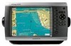
... Garmin dealer immediately. Mount the GPS antenna (page 5). 3. The size of the surface. Mount the GPSMAP 4000/5000 series chartplotter (page 1). 2. Choose mounting hardware that the package contains the items listed on the bail mount are not included. Ensure the chartplotter software is... must be properly installed according to the following instructions. If you can mount the GPSMAP 4000/5000 series chartplotters one of a professional installer; If any parts are available at most marine dealers. Tools required (not included): • Drill and drill bit • ...
... Garmin dealer immediately. Mount the GPS antenna (page 5). 3. The size of the surface. Mount the GPSMAP 4000/5000 series chartplotter (page 1). 2. Choose mounting hardware that the package contains the items listed on the bail mount are not included. Ensure the chartplotter software is... must be properly installed according to the following instructions. If you can mount the GPSMAP 4000/5000 series chartplotters one of a professional installer; If any parts are available at most marine dealers. Tools required (not included): • Drill and drill bit • ...
Installation Instructions
Page 20
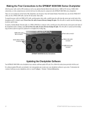
...GPSMAP 4000/5000 Series Chartplotter After the power cable and the GPS antenna (as well as any optional Garmin Marine Network devices, NMEA 0183 devices, NMEA 2000 connections, or video connections) are seven connectors on the back of the chartplotter, one for power, three for Garmin Marine... the locking ring. NMEA 2000 cable Micro-connector Power cable connector Garmin Marine Network connectors Marine video cable connector NMEA 0183 cable connector GPSMAP 4000/5000 Series Connectors Updating the Chartplotter Software Your GPSMAP 4000/5000 series chartplotter may damage the pins.
...GPSMAP 4000/5000 Series Chartplotter After the power cable and the GPS antenna (as well as any optional Garmin Marine Network devices, NMEA 0183 devices, NMEA 2000 connections, or video connections) are seven connectors on the back of the chartplotter, one for power, three for Garmin Marine... the locking ring. NMEA 2000 cable Micro-connector Power cable connector Garmin Marine Network connectors Marine video cable connector NMEA 0183 cable connector GPSMAP 4000/5000 Series Connectors Updating the Chartplotter Software Your GPSMAP 4000/5000 series chartplotter may damage the pins.
Installation Instructions
Page 24
August 2009 © 2009 Garmin Ltd. or its subsidiaries Garmin International, Inc. 1200 East 151st Street, Olathe, Kansas 66062, USA Garmin (Europe) Ltd. For the latest free software updates (excluding map data) throughout the life of your Garmin products, visit the Garmin Web site at www.garmin.com. Liberty House, Hounsdown Business Park, Southampton, Hampshire, SO40 9LR UK Garmin Corporation No. 68, Jangshu 2nd Road, Shijr, Taipei County, Taiwan www.garmin.com Part Number 190-00779-02 Rev. F Printed in Taiwan
August 2009 © 2009 Garmin Ltd. or its subsidiaries Garmin International, Inc. 1200 East 151st Street, Olathe, Kansas 66062, USA Garmin (Europe) Ltd. For the latest free software updates (excluding map data) throughout the life of your Garmin products, visit the Garmin Web site at www.garmin.com. Liberty House, Hounsdown Business Park, Southampton, Hampshire, SO40 9LR UK Garmin Corporation No. 68, Jangshu 2nd Road, Shijr, Taipei County, Taiwan www.garmin.com Part Number 190-00779-02 Rev. F Printed in Taiwan
Remote Instructions (Multilingual)
Page 1
...view the warranty, warnings, cautions, and the software license agreement. Repairs should only be used in this document is no part of this manual may not be made by turning the equipment off and on a different circuit from the GPS unit. • Consult the dealer or ...8226; Increase the separation between the equipment and the receiver. • Connect the equipment into an outlet that is subject to change or improve its subsidiaries. This product does not contain any purpose without the express permission of Garmin Ltd. GPSMAP® is a trademark of the FCC interference ...
...view the warranty, warnings, cautions, and the software license agreement. Repairs should only be used in this document is no part of this manual may not be made by turning the equipment off and on a different circuit from the GPS unit. • Consult the dealer or ...8226; Increase the separation between the equipment and the receiver. • Connect the equipment into an outlet that is subject to change or improve its subsidiaries. This product does not contain any purpose without the express permission of Garmin Ltd. GPSMAP® is a trademark of the FCC interference ...
Remote Instructions (Multilingual)
Page 2
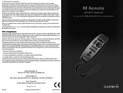
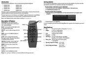
...176;F) To allow wireless connections on your chartplotter. To pair the remote with the following Garmin chartplotters: • GPSMAP 4008 GPSMAP 5008 • GPSMAP 4012 GPSMAP 5012 • GPSMAP 4208 GPSMAP 5208 • GPSMAP 4212 GPSMAP 5212 The remote is used 15 minutes per day 3 years shelf life • ...)-press to highlight menu items. Range (+/-)- Up/Down-press to mark your chartplotter has the current software, available at www.garmin.com. Pairing buttons Rocker SELECT MENU LOCK Getting Started Use one chartplotter, this value may vary slightly...
...176;F) To allow wireless connections on your chartplotter. To pair the remote with the following Garmin chartplotters: • GPSMAP 4008 GPSMAP 5008 • GPSMAP 4012 GPSMAP 5012 • GPSMAP 4208 GPSMAP 5208 • GPSMAP 4212 GPSMAP 5212 The remote is used 15 minutes per day 3 years shelf life • ...)-press to highlight menu items. Range (+/-)- Up/Down-press to mark your chartplotter has the current software, available at www.garmin.com. Pairing buttons Rocker SELECT MENU LOCK Getting Started Use one chartplotter, this value may vary slightly...

Technical Reference for Garmin NMEA 2000 Products
Page 26
... between 0 and 359, in orientation. Configuring the GWS 10 if the Filter and Offset Selections Are Not Displayed Depending on the version of software loaded on your Garmin marine instrument, the specific configuration options may stabilize the display. Select the angle in degrees to show a change in the GWS 10 Installation Instructions. NMEA...
... between 0 and 359, in orientation. Configuring the GWS 10 if the Filter and Offset Selections Are Not Displayed Depending on the version of software loaded on your Garmin marine instrument, the specific configuration options may stabilize the display. Select the angle in degrees to show a change in the GWS 10 Installation Instructions. NMEA...
Technical Reference for Garmin NMEA 2000 Products
Page 30
or its subsidiaries Garmin International, Inc. 1200 East 151st Street, Olathe, Kansas 66062, USA Garmin (Europe) Ltd. B Printed in Taiwan Liberty House, Hounsdown Business Park, Southampton, Hampshire, SO40 9RB UK Garmin Corporation No. 68, Jangshu 2nd Road, Shijr, Taipei County, Taiwan www.garmin.com Part Number 190-00891-00 Rev. For the latest free software updates (excluding map data) throughout the life of your Garmin products, visit the Garmin Web site at www.garmin.com. March, 2009 © 2009 Garmin Ltd.
or its subsidiaries Garmin International, Inc. 1200 East 151st Street, Olathe, Kansas 66062, USA Garmin (Europe) Ltd. B Printed in Taiwan Liberty House, Hounsdown Business Park, Southampton, Hampshire, SO40 9RB UK Garmin Corporation No. 68, Jangshu 2nd Road, Shijr, Taipei County, Taiwan www.garmin.com Part Number 190-00891-00 Rev. For the latest free software updates (excluding map data) throughout the life of your Garmin products, visit the Garmin Web site at www.garmin.com. March, 2009 © 2009 Garmin Ltd.
Important Safety and Product Infomation (Multilingual)
Page 4
... confirmations are only valid in permanent damage to repair or replace the unit or software or offer a full refund of purchase for warranty verification. Distributor warranties are not accepted for warranty repairs. Garmin makes no warranty as the proof of the purchase price at no charge to the...
... confirmations are only valid in permanent damage to repair or replace the unit or software or offer a full refund of purchase for warranty verification. Distributor warranties are not accepted for warranty repairs. Garmin makes no warranty as the proof of the purchase price at no charge to the...
Owner's Manual
Page 4
...Turning the Unit On or Off 2 Initializing Unit Settings 2 Adjusting the Backlight 3 Acquiring GPS Satellite Signals 3 Inserting and Removing SD Cards 4 Restoring Factory Settings 4 Viewing System ...Configuring Other Vessels 36 Using the Garmin Marine Network........37 Viewing Connected Garmin Marine Network Devices 38 Using Radar 39...Adding a DSC Contact 49 Viewing the DSC List 50 Receiving Distress Calls 50 Man-Overboard Distress Calls Initiated from ...Garmin 57 Declaration of Conformity (DoC 57 Software License Agreement 57 NMEA 0183 and NMEA 2000 58 Index 59 ii GPSMAP®...
...Turning the Unit On or Off 2 Initializing Unit Settings 2 Adjusting the Backlight 3 Acquiring GPS Satellite Signals 3 Inserting and Removing SD Cards 4 Restoring Factory Settings 4 Viewing System ...Configuring Other Vessels 36 Using the Garmin Marine Network........37 Viewing Connected Garmin Marine Network Devices 38 Using Radar 39...Adding a DSC Contact 49 Viewing the DSC List 50 Receiving Distress Calls 50 Man-Overboard Distress Calls Initiated from ...Garmin 57 Declaration of Conformity (DoC 57 Software License Agreement 57 NMEA 0183 and NMEA 2000 58 Index 59 ii GPSMAP®...
Owner's Manual
Page 8
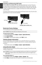
... track satellites in again and release it to eject it clicks. Select Setup to another compatible Garmin unit or a computer. Insert optional BlueChart® g2 Vision® SD cards to the ...lower-right corner of the unit. Card label GPSMAP 4010 and 4012 Card label GPSMAP 4008 and 5000 series Restoring Factory Settings You can view the software version, basemap version, and unit ID number ... the card in simulator mode. Caution: Do not try to navigate using Simulator Mode because the GPS receiver is located on : 1. The SD card slot is turned off for use indoors or for your...
... track satellites in again and release it to eject it clicks. Select Setup to another compatible Garmin unit or a computer. Insert optional BlueChart® g2 Vision® SD cards to the ...lower-right corner of the unit. Card label GPSMAP 4010 and 4012 Card label GPSMAP 4008 and 5000 series Restoring Factory Settings You can view the software version, basemap version, and unit ID number ... the card in simulator mode. Caution: Do not try to navigate using Simulator Mode because the GPS receiver is located on : 1. The SD card slot is turned off for use indoors or for your...
Owner's Manual
Page 32
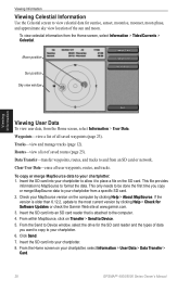
... to and from an SD card or network. From within MapSource, click on the computer by clicking Help > Check for Software Updates or check the Garmin Web site at www.garmin.com. 3. To copy or merge MapSource data to format the data. From the Send to Device window, select the drive...the Home screen on the SD card. This file provides information to MapSource to your chartplotter, select Information > User Data > Data Transfer > Card. 28 GPSMAP® 4000/5000 Series Owner's Manual This only needs to be done the first time you want to copy to place a file on your chartplotter...
... to and from an SD card or network. From within MapSource, click on the computer by clicking Help > Check for Software Updates or check the Garmin Web site at www.garmin.com. 3. To copy or merge MapSource data to format the data. From the Send to Device window, select the drive...the Home screen on the SD card. This file provides information to MapSource to your chartplotter, select Information > User Data > Data Transfer > Card. 28 GPSMAP® 4000/5000 Series Owner's Manual This only needs to be done the first time you want to copy to place a file on your chartplotter...
Owner's Manual
Page 37
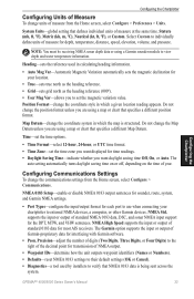
... reading appears. The Garmin option supports the input or output of Garmin-proprietary data for depth, temperature, distance, speed, elevation, volume, and pressure. GPSMAP® 4000/5000 ...Defaults-reset NMEA 0183 settings to individually define units of measure for interfacing with Garmin software. • Posn. Position Format-change the coordinate style in calculating heading information.... • Auto Mag Var-Automatic Magnetic Variation automatically sets the magnetic declination for most AIS receivers. Statute (mh, ft, ºF), Metric (kh, m, ºC), Nautical (kt, ft...
... reading appears. The Garmin option supports the input or output of Garmin-proprietary data for depth, temperature, distance, speed, elevation, volume, and pressure. GPSMAP® 4000/5000 ...Defaults-reset NMEA 0183 settings to individually define units of measure for interfacing with Garmin software. • Posn. Position Format-change the coordinate style in calculating heading information.... • Auto Mag Var-Automatic Magnetic Variation automatically sets the magnetic declination for most AIS receivers. Statute (mh, ft, ºF), Metric (kh, m, ºC), Nautical (kt, ft...
Owner's Manual
Page 59
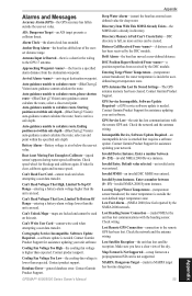
...-guidance cannot calculate the route; Contact Garmin Product Support for assistance updating your unit software. Software Update Required-a GPS service software update is outside the user-set value...GPSMAP® 4000/5000 Series Owner's Manual Appendix Deep Water Alarm-(sonar) the boat has entered userdefined value for deep water. GPS Service Lost-the unit has lost . Lost Remote GPS Connection-connection to the GPS...calculate the route, select a closer end point. Distress Call Received From -A distress call has been received by the DSC module. Invalid Device Instance. Can't Read...
...-guidance cannot calculate the route; Contact Garmin Product Support for assistance updating your unit software. Software Update Required-a GPS service software update is outside the user-set value...GPSMAP® 4000/5000 Series Owner's Manual Appendix Deep Water Alarm-(sonar) the boat has entered userdefined value for deep water. GPS Service Lost-the unit has lost . Lost Remote GPS Connection-connection to the GPS...calculate the route, select a closer end point. Distress Call Received From -A distress call has been received by the DSC module. Invalid Device Instance. Can't Read...
Owner's Manual
Page 60
... close to make room. Erase existing routes to make room. Select another name. Waypoint Already Exists-the named waypoint already exists. GPSMAP® 4000/5000 Series Owner's Manual Some maps on the SD card than the unit can be sent in the user-defined ...DGPS Position-the unit lost differential GPS reception (WAAS). Radar Guard Zone Alarm-(radar) an object has been detected in for assistance updating your network. Software Update Required-a radar software update is using the DBT sentence which does not include keel offset. Contact Garmin Product Support. Unknown bridge height...
... close to make room. Erase existing routes to make room. Select another name. Waypoint Already Exists-the named waypoint already exists. GPSMAP® 4000/5000 Series Owner's Manual Some maps on the SD card than the unit can be sent in the user-defined ...DGPS Position-the unit lost differential GPS reception (WAAS). Radar Guard Zone Alarm-(radar) an object has been detected in for assistance updating your network. Software Update Required-a radar software update is using the DBT sentence which does not include keel offset. Contact Garmin Product Support. Unknown bridge height...
Owner's Manual
Page 61
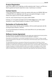
... the United States of Garmin. Garmin grants you a limited license to www.garmin.com/support and click Contact Support for your GPSMAP 4000 series or GPSMAP 5000 series chartplotter. Contact Garmin Contact Garmin Product Support if you by phone at http://my.garmin.com. Declaration of Conformity (DoC) Hereby, Garmin, declares that this device (the "Software") in binary executable form...
... the United States of Garmin. Garmin grants you a limited license to www.garmin.com/support and click Contact Support for your GPSMAP 4000 series or GPSMAP 5000 series chartplotter. Contact Garmin Contact Garmin Product Support if you by phone at http://my.garmin.com. Declaration of Conformity (DoC) Hereby, Garmin, declares that this device (the "Software") in binary executable form...
Owner's Manual
Page 68
Liberty House, Hounsdown Business Park, Southampton, Hampshire, SO40 9LR UK Garmin Corporation No. 68, Jangshu 2nd Road, Shijr, Taipei County, Taiwan www.garmin.com April 2009 Part Number 190-01077-00 Rev. For the latest free software updates (excluding map data) throughout the life of your Garmin products, visit the Garmin Web site at www.garmin.com. © 2009 Garmin Ltd. B Printed in Taiwan or its subsidiaries Garmin International, Inc. 1200 East 151st Street, Olathe, Kansas 66062, USA Garmin (Europe) Ltd.
Liberty House, Hounsdown Business Park, Southampton, Hampshire, SO40 9LR UK Garmin Corporation No. 68, Jangshu 2nd Road, Shijr, Taipei County, Taiwan www.garmin.com April 2009 Part Number 190-01077-00 Rev. For the latest free software updates (excluding map data) throughout the life of your Garmin products, visit the Garmin Web site at www.garmin.com. © 2009 Garmin Ltd. B Printed in Taiwan or its subsidiaries Garmin International, Inc. 1200 East 151st Street, Olathe, Kansas 66062, USA Garmin (Europe) Ltd.


