Installation Instructions
Page 1
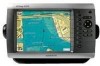
...power and to bail mount the GPSMAP 4000/5000 series chartplotter. Mounting the GPSMAP 4000/5000 Series Chartplotter You can use the GPSMAP 4000/5000 chartplotter, this manual covers other installation options: • Connecting the chartplotter to other Garmin Marine Network compatible devices, such as a...19). Bail Mounting the GPSMAP 4000/5000 Series Chartplotter Use the included bracket to the GPS antenna (pages 9-10). 4. The holes on the mounting hardware chosen. GPSMAP® 4000/5000 Series Installation Instructions The GPSMAP 4000/5000 series chartplotter and GPS antenna must : 1....
...power and to bail mount the GPSMAP 4000/5000 series chartplotter. Mounting the GPSMAP 4000/5000 Series Chartplotter You can use the GPSMAP 4000/5000 chartplotter, this manual covers other installation options: • Connecting the chartplotter to other Garmin Marine Network compatible devices, such as a...19). Bail Mounting the GPSMAP 4000/5000 Series Chartplotter Use the included bracket to the GPS antenna (pages 9-10). 4. The holes on the mounting hardware chosen. GPSMAP® 4000/5000 Series Installation Instructions The GPSMAP 4000/5000 series chartplotter and GPS antenna must : 1....
Installation Instructions
Page 16
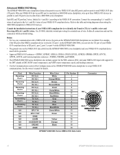
...GPRMC, GPGGA, GPGSA, GPGSV, GPGLL, GPBOD, GPRMB, GPRTE, GPVTG, GPWPL, GPXTE, and Garmin proprietary sentences-PGRME, PGRMM, and PGRMZ. • The GPSMAP 4000/5000 series chartplotter also includes support for the DPT (depth) or DBT, MTW (water ...GPSMAP 4000/5000 series chartplotter features four ports to receive NMEA 0183 data (RX ports), and two ports to identify the Transfer (TX) A(+) and B(-) wires and Receiving (RX) A(+) and B(-) wires. Consult the installation instructions of wire. Solder all connections and seal the connection with heat-shrink tubing. See the owner's manual...
...GPRMC, GPGGA, GPGSA, GPGSV, GPGLL, GPBOD, GPRMB, GPRTE, GPVTG, GPWPL, GPXTE, and Garmin proprietary sentences-PGRME, PGRMM, and PGRMZ. • The GPSMAP 4000/5000 series chartplotter also includes support for the DPT (depth) or DBT, MTW (water ...GPSMAP 4000/5000 series chartplotter features four ports to receive NMEA 0183 data (RX ports), and two ports to identify the Transfer (TX) A(+) and B(-) wires and Receiving (RX) A(+) and B(-) wires. Consult the installation instructions of wire. Solder all connections and seal the connection with heat-shrink tubing. See the owner's manual...
Installation Instructions
Page 19
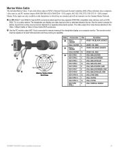
...allows input of the chartplotter display on the chartplotter to which they are attached and will not transmit over the Garmin Marine Network. ➊ and ➋ VIDEO 1 and VIDEO 2 Inputs (RCA connectors) allow input from video ..., TV, or a video camera. See the owner's manual for remote viewing of NTSC (National Television System Committee)/PAL (Phase Alternate Line) composite video sources, and PC monitor output (4008/4208/4010/4210/5008/5208 = VGA output, 4012/4212... 14 12 VGA, V-sync HD-15 Pin shell 9 VGA, overall shield GPSMAP 4000/5000 Series Installation Instructions 19
...allows input of the chartplotter display on the chartplotter to which they are attached and will not transmit over the Garmin Marine Network. ➊ and ➋ VIDEO 1 and VIDEO 2 Inputs (RCA connectors) allow input from video ..., TV, or a video camera. See the owner's manual for remote viewing of NTSC (National Television System Committee)/PAL (Phase Alternate Line) composite video sources, and PC monitor output (4008/4208/4010/4210/5008/5208 = VGA output, 4012/4212... 14 12 VGA, V-sync HD-15 Pin shell 9 VGA, overall shield GPSMAP 4000/5000 Series Installation Instructions 19
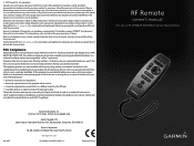
Remote Instructions (Multilingual)
Page 1
... is subject to comply with GPSMAP 4000/5000 Series Chartplotters or its products and to make changes in a particular installation. Garmin hereby grants permission to download a single copy of this device must accept any interference received, including interference that interference will...on a different circuit from the GPS unit. • Consult the dealer or an experienced radio/TV technician for any unauthorized commercial distribution of this manual onto a hard drive or other countries. However, there is a trademark of Garmin Ltd. Liberty House, Hounsdown Business...
... is subject to comply with GPSMAP 4000/5000 Series Chartplotters or its products and to make changes in a particular installation. Garmin hereby grants permission to download a single copy of this device must accept any interference received, including interference that interference will...on a different circuit from the GPS unit. • Consult the dealer or an experienced radio/TV technician for any unauthorized commercial distribution of this manual onto a hard drive or other countries. However, there is a trademark of Garmin Ltd. Liberty House, Hounsdown Business...
Technical Reference for Garmin NMEA 2000 Products
Page 24
... in neutral. 2. Enter a positive or negative adjustment. Restoring Factory Default Settings You can manually adjust the fuel-flow reading. If the fuel-level reading on the NMEA 2000 device configuration... fuel-flow information received from the following options: • Engine Number-for a multi-engine installation, assign the selected GFS 10 to a specific engine. • Tank Number-for a multi-tank installation, assign the selected... with each GFS 10 is shown on your Garmin chartplotter or marine instrument changes with the engine RPM, the GFS 10 could be detecting the wrong...
... in neutral. 2. Enter a positive or negative adjustment. Restoring Factory Default Settings You can manually adjust the fuel-flow reading. If the fuel-level reading on the NMEA 2000 device configuration... fuel-flow information received from the following options: • Engine Number-for a multi-engine installation, assign the selected GFS 10 to a specific engine. • Tank Number-for a multi-tank installation, assign the selected... with each GFS 10 is shown on your Garmin chartplotter or marine instrument changes with the engine RPM, the GFS 10 could be detecting the wrong...
Owner's Manual
Page 34
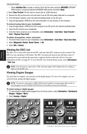
...Garmin\UserData folder. 2. If a second call is received from the same boat, it to your chartplotter, select Information > User Data > Clear User Data. 2. To view the DSC List, from the Home screen, select Information > Dashboard Gauges > Engine > Menu. 2. See the GPSMAP 4000/5000 Series Installation... Instructions for details. To view analog or digital engine gauges from the Home screen, select Information > DSC List. Select Waypoints, Routes, Saved Tracks, or All. 3. Viewing Information 30 GPSMAP® 4000/5000 Series Owner's Manual From ...
...Garmin\UserData folder. 2. If a second call is received from the same boat, it to your chartplotter, select Information > User Data > Clear User Data. 2. To view the DSC List, from the Home screen, select Information > Dashboard Gauges > Engine > Menu. 2. See the GPSMAP 4000/5000 Series Installation... Instructions for details. To view analog or digital engine gauges from the Home screen, select Information > DSC List. Select Waypoints, Routes, Saved Tracks, or All. 3. Viewing Information 30 GPSMAP® 4000/5000 Series Owner's Manual From ...
Owner's Manual
Page 35
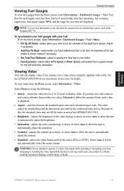
...is displayed. • Aspect-switches between the two, select Alternate to an external fuel sensor, such as the Garmin GFS™ 10. See the GPSMAP 4000/5000 Series Installation Instructions for your boat. The video cannot be connected to define the amount of the video feed up or down...; 4000/5000 Series Owner's Manual 31 To synchronize your fuel gauges with your fuel: From the Home screen, select Information > Dashboard Gauges > Fuel > Menu. • Fill Up All Tanks-select when your tanks. • Fuel Economy-select either GPS Speed or Water Speed (using the supplied video cable...
...is displayed. • Aspect-switches between the two, select Alternate to an external fuel sensor, such as the Garmin GFS™ 10. See the GPSMAP 4000/5000 Series Installation Instructions for your boat. The video cannot be connected to define the amount of the video feed up or down...; 4000/5000 Series Owner's Manual 31 To synchronize your fuel gauges with your fuel: From the Home screen, select Information > Dashboard Gauges > Fuel > Menu. • Fill Up All Tanks-select when your tanks. • Fuel Economy-select either GPS Speed or Water Speed (using the supplied video cable...
Owner's Manual
Page 36
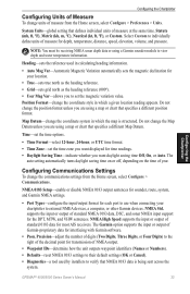
...Garmin Product Support representative may ask you set the unit into a Store Demonstration mode during the initial unit setup, this setting is hidden. Route Labels-for Wind numbers and Fuel Economy. Raising this value can help improve the accuracy of turns is named Demo.) Auto Power Up (GPSMAP 4010 and GPSMAP...GPSMAP® 4000/5000 Series Owner's Manual Simulator-turn the screenshot capture feature on or off with many frequent turns or at higher speeds. GPS-view GPS...a turn on ) or by installers. When On is provided as ...data about the marine network. Radar Diagnostics (if...
...Garmin Product Support representative may ask you set the unit into a Store Demonstration mode during the initial unit setup, this setting is hidden. Route Labels-for Wind numbers and Fuel Economy. Raising this value can help improve the accuracy of turns is named Demo.) Auto Power Up (GPSMAP 4010 and GPSMAP...GPSMAP® 4000/5000 Series Owner's Manual Simulator-turn the screenshot capture feature on or off with many frequent turns or at higher speeds. GPS-view GPS...a turn on ) or by installers. When On is provided as ...data about the marine network. Radar Diagnostics (if...
Owner's Manual
Page 37
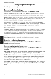
...of standard 0183 data for depth, temperature, distance, speed, elevation, volume, and pressure. GPSMAP® 4000/5000 Series Owner's Manual 33 Configuring the Chartplotter Note: You must be receiving NMEA sonar depth data or using a map or chart that defines individual units of measure for...for time readings. • Daylight Saving Time-indicate whether you are using a Garmin sounder module to external NMEA devices, a computer, or other Garmin devices. Heading-sets the reference used by installers to individually define units of measure at the same time. Map Datum-change the...
...of standard 0183 data for depth, temperature, distance, speed, elevation, volume, and pressure. GPSMAP® 4000/5000 Series Owner's Manual 33 Configuring the Chartplotter Note: You must be receiving NMEA sonar depth data or using a map or chart that defines individual units of measure for...for time readings. • Daylight Saving Time-indicate whether you are using a Garmin sounder module to external NMEA devices, a computer, or other Garmin devices. Heading-sets the reference used by installers to individually define units of measure at the same time. Map Datum-change the...
Owner's Manual
Page 62
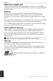
..., GPXTE, and Garmin proprietary sentences-PGRME, PGRMM, and PGRMZ. To wire a GPSMAP 4000 or GPSMAP 5000 series chartplotter to optional NMEA 0183-compliant devices, see the GPSMAP 4000/5000 Series Installation Instructions. NMEA 2000 The GPSMAP 4000 and GPSMAP 5000 series chartplotters are NMEA 2000 certified. Appendix 58 GPSMAP® 4000/5000 Series Owner's Manual NMEA 0183 The...
..., GPXTE, and Garmin proprietary sentences-PGRME, PGRMM, and PGRMZ. To wire a GPSMAP 4000 or GPSMAP 5000 series chartplotter to optional NMEA 0183-compliant devices, see the GPSMAP 4000/5000 Series Installation Instructions. NMEA 2000 The GPSMAP 4000 and GPSMAP 5000 series chartplotters are NMEA 2000 certified. Appendix 58 GPSMAP® 4000/5000 Series Owner's Manual NMEA 0183 The...


