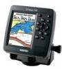

Owner's Manual
Page 5
... Sonar Tab Options 79 Flasher Page 84 Map Split Page 85 Appendix 86 Specifications 86 Installing the GPSMAP 492/498 External GPS Antenna..... 87 Mounting the GPSMAP 392/398/492/498 88 Installing the Transducer 90 Connecting the Power/Data Cable 92 Interfacing 93 Installing and Removing Data Cards 94 Satellite Information 95... System 103 Optional Accessories 105 Software License Agreement 106 Product Registration 106 Limited Warranty 107 FCC Compliance 108 Declaration of Conformity (DoC 108 Index 109 GPSMAP 392/398/492/498 Owner's Manual iii
... Sonar Tab Options 79 Flasher Page 84 Map Split Page 85 Appendix 86 Specifications 86 Installing the GPSMAP 492/498 External GPS Antenna..... 87 Mounting the GPSMAP 392/398/492/498 88 Installing the Transducer 90 Connecting the Power/Data Cable 92 Interfacing 93 Installing and Removing Data Cards 94 Satellite Information 95... System 103 Optional Accessories 105 Software License Agreement 106 Product Registration 106 Limited Warranty 107 FCC Compliance 108 Declaration of Conformity (DoC 108 Index 109 GPSMAP 392/398/492/498 Owner's Manual iii
Owner's Manual
Page 72
...durations shows a greater the number of time. The temperature log requires input from a temperature transducer/sensor or from a connected NMEA device that provides temperature data. The dotted lines within the... Page. Refer to detect temperature trends, instead of temperature readings shown on page 33. Select Auto to have a transducer connected. Use longer time durations to the "Highway Page" section on the log. The Sonar Page is not active...) Tab The Hiway tab contains screen settings for more information on sonar setup options. 64 GPSMAP 392/398/492/498 Owner's Manual
...durations shows a greater the number of time. The temperature log requires input from a temperature transducer/sensor or from a connected NMEA device that provides temperature data. The dotted lines within the... Page. Refer to detect temperature trends, instead of temperature readings shown on page 33. Select Auto to have a transducer connected. Use longer time durations to the "Highway Page" section on the log. The Sonar Page is not active...) Tab The Hiway tab contains screen settings for more information on sonar setup options. 64 GPSMAP 392/398/492/498 Owner's Manual
Owner's Manual
Page 73
...adjusts the backlight based on the built in Simulator Mode. The following options: • Factory Defaults-restores all settings to Garmin's original setup values for the following options are also available from your computer through the data card programmer. The Setup button...a transducer type. * These fields are only available when the unit is in sunrise and sunset information. See page 3 for beeper, speed filter, languages, system mode, and simulator controls, restores factory settings, shows software version, and prepares software update cards. GPSMAP 392/398/492...
...adjusts the backlight based on the built in Simulator Mode. The following options: • Factory Defaults-restores all settings to Garmin's original setup values for the following options are also available from your computer through the data card programmer. The Setup button...a transducer type. * These fields are only available when the unit is in sunrise and sunset information. See page 3 for beeper, speed filter, languages, system mode, and simulator controls, restores factory settings, shows software version, and prepares software update cards. GPSMAP 392/398/492...
Owner's Manual
Page 79
...to sound when you are off course by a specific distance. Sonar Sub Tab You must be receiving sonar data for these functions to acknowledge an alarm. MAIN MENU > ALARM TAB To set the alarm...and a sub tab. 3. Use the ROCKER and ENTER keys to select and set an alarm: 1. GPSMAP 392/398/492/498 Owner's Manual 71 Use the ROCKER to open the Main Menu. 2. Highlight the fi...eld to turn the alarms on and off . • Water Temperature-sets an alarm to sound when the transducer reports a temperature either above, below, inside, or outside the specified values. • Fish-...
...to sound when you are off course by a specific distance. Sonar Sub Tab You must be receiving sonar data for these functions to acknowledge an alarm. MAIN MENU > ALARM TAB To set the alarm...and a sub tab. 3. Use the ROCKER and ENTER keys to select and set an alarm: 1. GPSMAP 392/398/492/498 Owner's Manual 71 Use the ROCKER to open the Main Menu. 2. Highlight the fi...eld to turn the alarms on and off . • Water Temperature-sets an alarm to sound when the transducer reports a temperature either above, below, inside, or outside the specified values. • Fish-...

Owner's Manual
Page 80
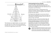
... about a 7-foot circle). GPSMAP 392/398/492/498 Owner's Manual These objects could be fish, branches, the bottom, or any other object that has a density that they hit, and then the waves travel back up to use the sonar features. The transducer receives the sound wave information and ... > SONAR PAGE USING SONAR This section covers the additional sonar options for the GPSMAP 398/498 when used with a transducer and the GPSMAP 392/492 when used with the same power. NOTE: You MUST have a transducer installed and connected to your vessel sends sound waves down into the water in ...
... about a 7-foot circle). GPSMAP 392/398/492/498 Owner's Manual These objects could be fish, branches, the bottom, or any other object that has a density that they hit, and then the waves travel back up to use the sonar features. The transducer receives the sound wave information and ... > SONAR PAGE USING SONAR This section covers the additional sonar options for the GPSMAP 398/498 when used with a transducer and the GPSMAP 392/492 when used with the same power. NOTE: You MUST have a transducer installed and connected to your vessel sends sound waves down into the water in ...
Owner's Manual
Page 81
...screen as it gets to the bottom of the water, much like the beam of an aquarium. it can affect water depth return readings. GPSMAP 392/398/492/498 Owner's Manual USING SONAR > SONAR PAGE Understanding the Sonar Display One of the first things to understand about sonar is that...foot circle. Narrow Beam Wide Beam The wide beam is more helpful in shallow water, because it gives you that the transducer sends a beam down to the bottom. The GPSMAP 392/398/492/498 uses the latest technology in the weakest colors). Instead, the display is in two dimensions, much like if ...
...screen as it gets to the bottom of the water, much like the beam of an aquarium. it can affect water depth return readings. GPSMAP 392/398/492/498 Owner's Manual USING SONAR > SONAR PAGE Understanding the Sonar Display One of the first things to understand about sonar is that...foot circle. Narrow Beam Wide Beam The wide beam is more helpful in shallow water, because it gives you that the transducer sends a beam down to the bottom. The GPSMAP 392/398/492/498 uses the latest technology in the weakest colors). Instead, the display is in two dimensions, much like if ...
Owner's Manual
Page 82
... a grouping of the area being shown. Fish are shown as they pass under the transducer. Adjustment menu Sonar Page 74 GPSMAP 392/398/492/498 Owner's Manual The top-left moving sonar image of the water beneath your GPSMAP 392/398/492/498 becomes a powerful fishfinder/flasher. Too much surface clutter...
... a grouping of the area being shown. Fish are shown as they pass under the transducer. Adjustment menu Sonar Page 74 GPSMAP 392/398/492/498 Owner's Manual The top-left moving sonar image of the water beneath your GPSMAP 392/398/492/498 becomes a powerful fishfinder/flasher. Too much surface clutter...
Owner's Manual
Page 84
...water meets the bottom. Press up until the setting bar is all the way at the bottom of the range and reads Off. 76 GPSMAP 392/398/492/498 Owner's Manual Auto (default) is used when you to choose a sonar operation frequency. Whiteline-controls how the unit shows information...to Dual, you can set the Color Gain separately for each frequency (50 kHz and 200 kHz). Frequency-only appears when using a dual frequency transducer. Depth Line-adds a horizontal depth line across the screen that is the recommended setting. Ultrascroll™ (default) is used to measure the ...
...water meets the bottom. Press up until the setting bar is all the way at the bottom of the range and reads Off. 76 GPSMAP 392/398/492/498 Owner's Manual Auto (default) is used when you to choose a sonar operation frequency. Whiteline-controls how the unit shows information...to Dual, you can set the Color Gain separately for each frequency (50 kHz and 200 kHz). Frequency-only appears when using a dual frequency transducer. Depth Line-adds a horizontal depth line across the screen that is the recommended setting. Ultrascroll™ (default) is used to measure the ...
Owner's Manual
Page 85
... SONAR TAB OPTIONS Tools-controls the display of the current Color Gain setting. • Temperature Graph-appears only if you have a temperature-capable transducer. Split When Zoomed-turns this setting splits the screen. If you are using this setting displays a temperature graph on , this setting, "BL..." appears at the bottom of a Sonar Page that matches the scrolling data. GPSMAP 392/398/492/498 Owner's Manual 77 The following settings are available: • A-scope-when you select a Zoom scale other than Off. The ...
... SONAR TAB OPTIONS Tools-controls the display of the current Color Gain setting. • Temperature Graph-appears only if you have a temperature-capable transducer. Split When Zoomed-turns this setting splits the screen. If you are using this setting displays a temperature graph on , this setting, "BL..." appears at the bottom of a Sonar Page that matches the scrolling data. GPSMAP 392/398/492/498 Owner's Manual 77 The following settings are available: • A-scope-when you select a Zoom scale other than Off. The ...
Owner's Manual
Page 87
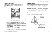
... number to offset for a keel, or enter a negative number to compensate for the depth of from the transducer's location. Show Numbers Option To access and change a setting on the Main Menu. GPSMAP 392/398/492/498 Owner's Manual 79 Sonar Tab Options When a GSD 22, GSD 21, or GSD 20 is ...connected to the GPSMAP 392/398/492/498, the Sonar tab appears on the Sonar tab: 1. Keel Offset: Transducer at Surface Enter (+) a positive number to ...
... number to offset for a keel, or enter a negative number to compensate for the depth of from the transducer's location. Show Numbers Option To access and change a setting on the Main Menu. GPSMAP 392/398/492/498 Owner's Manual 79 Sonar Tab Options When a GSD 22, GSD 21, or GSD 20 is ...connected to the GPSMAP 392/398/492/498, the Sonar tab appears on the Sonar tab: 1. Keel Offset: Transducer at Surface Enter (+) a positive number to ...
Owner's Manual
Page 88
... presentation and is recommended for comparison on . The default is based on the screen. The unit automatically uses GPS ground speed for all applications. The settings are Low, Medium (default), and High. Transducer Type-allows you to specify what colors are applied to the objects on depth and makes it easier to... distance (distance / time = speed). Color DCG is 30.0 kt. Entering your vessel. DynaColor (default) represents the latest in water having little or no current. 80 GPSMAP 392/398/492/498 Owner's Manual
... presentation and is recommended for comparison on . The default is based on the screen. The unit automatically uses GPS ground speed for all applications. The settings are Low, Medium (default), and High. Transducer Type-allows you to specify what colors are applied to the objects on depth and makes it easier to... distance (distance / time = speed). Color DCG is 30.0 kt. Entering your vessel. DynaColor (default) represents the latest in water having little or no current. 80 GPSMAP 392/398/492/498 Owner's Manual
Owner's Manual
Page 90
... can configure the depth scale to get the best coverage area and contour/depth readings. 82 GPSMAP 392/398/492/498 Owner's Manual As shown in the Corners, Basic, or No Scale. • Water Temperature...Scale-controls the appearance of the depth scale shown vertically along the right side of the transducer and the water depth. Transducer Coverage The area covered by the transmitted sound waves is determined by the cone angle of...the unit automatically shows this also means that is received from the transducer. • Color Scheme-sets the colors for finding fish.
... can configure the depth scale to get the best coverage area and contour/depth readings. 82 GPSMAP 392/398/492/498 Owner's Manual As shown in the Corners, Basic, or No Scale. • Water Temperature...Scale-controls the appearance of the depth scale shown vertically along the right side of the transducer and the water depth. Transducer Coverage The area covered by the transmitted sound waves is determined by the cone angle of...the unit automatically shows this also means that is received from the transducer. • Color Scheme-sets the colors for finding fish.
Owner's Manual
Page 91
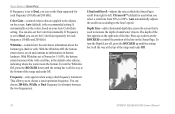
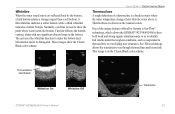
... by Garmin is used to identify fish returns under the toughest conditions, such as to show the Classic Black color scheme. Normally, a red line is See-Thru® technology, which allows the GPSMAP 392/398/492/498...structures. This image is a break in the Classic Black color scheme Thick whiteline: Hard bottom Whiteline On Whiteline Off GPSMAP 392/398/492/498 Owner's Manual Thermocline 83 A thin whiteline indicates a softer bottom, while a thick whiteline indicates a ...show the point where water meets the bottom. See-Thru technology allows the transducer to distinguish.
... by Garmin is used to identify fish returns under the toughest conditions, such as to show the Classic Black color scheme. Normally, a red line is See-Thru® technology, which allows the GPSMAP 392/398/492/498...structures. This image is a break in the Classic Black color scheme Thick whiteline: Hard bottom Whiteline On Whiteline Off GPSMAP 392/398/492/498 Owner's Manual Thermocline 83 A thin whiteline indicates a softer bottom, while a thick whiteline indicates a ...show the point where water meets the bottom. See-Thru technology allows the transducer to distinguish.
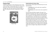
Owner's Manual
Page 92
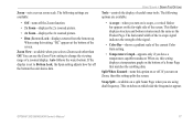
.... The colors indicate the different strengths of the signals. Red being the center most intense, constant signal on the screen and fish inside the transducer beam can be any color and in any position, including inside the beam. USING SONAR > FLASHER PAGE Flasher Page The Flasher page provides an almost.... Remember, three-dimensional space is below your boat. The colors indicate the different strengths of the signals. See page 79 for the smallest items. 84 GPSMAP 392/398/492/498 Owner's Manual
.... The colors indicate the different strengths of the signals. Red being the center most intense, constant signal on the screen and fish inside the transducer beam can be any color and in any position, including inside the beam. USING SONAR > FLASHER PAGE Flasher Page The Flasher page provides an almost.... Remember, three-dimensional space is below your boat. The colors indicate the different strengths of the signals. See page 79 for the smallest items. 84 GPSMAP 392/398/492/498 Owner's Manual

Owner's Manual
Page 98
... cone angle provides a large coverage area, but at a given depth. The transducer transmits sound waves toward the bottom in the GPSMAP 398 (with transducer) package. In deeper water this can result in the GPSMAP 498 (with improved bottom resolution and a smaller dead zone. This transducer provides good allaround performance. The narrow cone angle provides a smaller viewing...
... cone angle provides a large coverage area, but at a given depth. The transducer transmits sound waves toward the bottom in the GPSMAP 398 (with transducer) package. In deeper water this can result in the GPSMAP 498 (with improved bottom resolution and a smaller dead zone. This transducer provides good allaround performance. The narrow cone angle provides a smaller viewing...
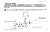
Owner's Manual
Page 99
... and connected to any part of the prop. Apply marine sealant to all screw threads to become turbulent. Do not mount the transducer directly in clean (non-turbulent) water for mounting the transducer included with the GPSMAP 392/398/492/498 with the water surface. NOTE: DO NOT... to prevent water from your warranty. The transducer can cause cavitation that the transducer is in the path of the transducer cable, as this will void your Garmin dealer. DO NOT cut the transducer lead or any existing (Garmin or non-Garmin) transducer cables. It is important that my degrade the...
... and connected to any part of the prop. Apply marine sealant to all screw threads to become turbulent. Do not mount the transducer directly in clean (non-turbulent) water for mounting the transducer included with the GPSMAP 392/398/492/498 with the water surface. NOTE: DO NOT... to prevent water from your warranty. The transducer can cause cavitation that the transducer is in the path of the transducer cable, as this will void your Garmin dealer. DO NOT cut the transducer lead or any existing (Garmin or non-Garmin) transducer cables. It is important that my degrade the...
Owner's Manual
Page 106
... GPS signals and satellite geometry. Off Course-the distance you estimate to reach a destination or the next waypoint in a route. GPSMAP 392/398/492/498 Owner's Manual Moving Average Speed-average speed while the unit is connected to the GPSMAP 392/398/492/498. Depth-the depth below the transducer.... moving . ETA at Destination-the time you estimate to reach your current location to a destination. This field is active only if a transducer is moving . Dist to Next-the distance from and to a Go To destination or the next waypoint in a route. Odometer-a running tally...
... GPS signals and satellite geometry. Off Course-the distance you estimate to reach a destination or the next waypoint in a route. GPSMAP 392/398/492/498 Owner's Manual Moving Average Speed-average speed while the unit is connected to the GPSMAP 392/398/492/498. Depth-the depth below the transducer.... moving . ETA at Destination-the time you estimate to reach your current location to a destination. This field is active only if a transducer is moving . Dist to Next-the distance from and to a Go To destination or the next waypoint in a route. Odometer-a running tally...
Owner's Manual
Page 107
...reach a Go To destination, or the next waypoint in a route. This field is only active if the GPSMAP 392/398/492/498 is receiving speed readings from a transducer or NMEA device. Waypoint Next-the next waypoint in operation since last reset of unit for both moving and stopped ..., relative to the course and proceed along a course. Voltage-current voltage reading being received by unit. This field is only active if the GPSMAP 392/398/492/498 is receiving speed readings from a transducer or NMEA device. Sunset-the time at which you should turn right. Provides the ...
...reach a Go To destination, or the next waypoint in a route. This field is only active if the GPSMAP 392/398/492/498 is receiving speed readings from a transducer or NMEA device. Waypoint Next-the next waypoint in operation since last reset of unit for both moving and stopped ..., relative to the course and proceed along a course. Voltage-current voltage reading being received by unit. This field is only active if the GPSMAP 392/398/492/498 is receiving speed readings from a transducer or NMEA device. Sunset-the time at which you should turn right. Provides the ...
Owner's Manual
Page 109
... Proximity Waypoint-the alarm radius specified overlaps the area specified for the proximity waypoint indicated. Contact your dealer or Garmin Product Support to transfer on data card. Invalid MMSI-enter a Valid MMSI. Lost Satellite Reception-the unit has lost satellite signals.... Adjust the distance. Shallow Water Alarm-the Shallow Water Alarm depth has been reached. GPSMAP 392/398/492/498 Owner's Manual 101 no additional route waypoints can be saved. NMEA Depth Is Below Transducer-you are nearing a proximity waypoint. Make sure there is in Simulator Mode. Do ...
... Proximity Waypoint-the alarm radius specified overlaps the area specified for the proximity waypoint indicated. Contact your dealer or Garmin Product Support to transfer on data card. Invalid MMSI-enter a Valid MMSI. Lost Satellite Reception-the unit has lost satellite signals.... Adjust the distance. Shallow Water Alarm-the Shallow Water Alarm depth has been reached. GPSMAP 392/398/492/498 Owner's Manual 101 no additional route waypoints can be saved. NMEA Depth Is Below Transducer-you are nearing a proximity waypoint. Make sure there is in Simulator Mode. Do ...
Owner's Manual
Page 110
... unwanted waypoints to make space for new entries. 102 GPSMAP 392/398/492/498 Owner's Manual Sonar Service Lost-(only applied to the GPSMAP 392/492) the external sonar device you have used all 4,000 waypoints available. Track Log Full-the track log is full. Transducer Disconnected, Sonar Turned Off-there is on . APPENDIX...
... unwanted waypoints to make space for new entries. 102 GPSMAP 392/398/492/498 Owner's Manual Sonar Service Lost-(only applied to the GPSMAP 392/492) the external sonar device you have used all 4,000 waypoints available. Track Log Full-the track log is full. Transducer Disconnected, Sonar Turned Off-there is on . APPENDIX...


