
Owner's Manual
Page 3
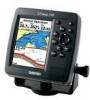
... portable GPS receiver. The Using Sonar section provides detailed explanations about the Main Menu and how to use it to indicate a potentially hazardous situation, which , if not avoided, may result in the Appendix. Manual Conventions This manual uses the term Warning to configure your unit. If any question about installing your chartplotter, contact Garmin Product Support or a professional installer. The GPSMAP 392/398/492/498 Sounder...
... portable GPS receiver. The Using Sonar section provides detailed explanations about the Main Menu and how to use it to indicate a potentially hazardous situation, which , if not avoided, may result in the Appendix. Manual Conventions This manual uses the term Warning to configure your unit. If any question about installing your chartplotter, contact Garmin Product Support or a professional installer. The GPSMAP 392/398/492/498 Sounder...
Owner's Manual
Page 4
... Information vi Basic Operation 1 Initializing the Receiver 1 Simulator Mode 3 Adjusting the Backlight 4 Interface Keys 5 Entering Data and Selecting Options 6 Using the Map Pointer 7 Creating and Using Waypoints 8 Man OverBoard (MOB 10 Reviewing and Editing Waypoints 11 Navigating to a Destination 12 Creating and Using Routes 17 Find 19 Additional Information 21 DSC (Digital Selective Calling 21 AIS 25 Main Pages 26 Map Page 27 Compass Page 32 3D Highway Page 33 Active Route Page 36 Main Menu 37 GPS...
... Information vi Basic Operation 1 Initializing the Receiver 1 Simulator Mode 3 Adjusting the Backlight 4 Interface Keys 5 Entering Data and Selecting Options 6 Using the Map Pointer 7 Creating and Using Waypoints 8 Man OverBoard (MOB 10 Reviewing and Editing Waypoints 11 Navigating to a Destination 12 Creating and Using Routes 17 Find 19 Additional Information 21 DSC (Digital Selective Calling 21 AIS 25 Main Pages 26 Map Page 27 Compass Page 32 3D Highway Page 33 Active Route Page 36 Main Menu 37 GPS...

Owner's Manual
Page 9
... is shipped from the factory in a location with a clear and unobstructed view of the sky. Install the antenna in AutoLocate Mode. A full-screen GPS Information Page is blank, release the POWER key. 1 To turn off the GPSMAP 392/398/492/498: 1. To turn on the GPSMAP 392/398/492/498: 1. BASIC OPERATION Initializing the Receiver The first time you start the Retail Demonstration?". Press ENTER to answer NO...
... is shipped from the factory in a location with a clear and unobstructed view of the sky. Install the antenna in AutoLocate Mode. A full-screen GPS Information Page is blank, release the POWER key. 1 To turn off the GPSMAP 392/398/492/498: 1. To turn on the GPSMAP 392/398/492/498: 1. BASIC OPERATION Initializing the Receiver The first time you start the Retail Demonstration?". Press ENTER to answer NO...
Owner's Manual
Page 12
... the Setup button next to the Simulator field on the ROCKER increase the speed in 10 knot/kph/mph increments. Highlight Set Position, and press ENTER to set the track. 6. Press the POWER key again and the user-defined level of backlighting starts. GPSMAP 392/398/492/498 Owner's Manual Highlight the Speed field, and then press ENTER. Use the ROCKER to change the simulated location. 7. Press ENTER...
... the Setup button next to the Simulator field on the ROCKER increase the speed in 10 knot/kph/mph increments. Highlight Set Position, and press ENTER to set the track. 6. Press the POWER key again and the user-defined level of backlighting starts. GPSMAP 392/398/492/498 Owner's Manual Highlight the Speed field, and then press ENTER. Use the ROCKER to change the simulated location. 7. Press ENTER...
Owner's Manual
Page 16
... and symbol are created for each waypoint. You can enter a new waypoint's location coordinates manually. To select a different symbol, highlight the symbol field to enter the new alphanumeric name, and press ENTER/MARK when finished. BASIC OPERATION > CREATING AND USING WAYPOINTS Creating and Using Waypoints The GPSMAP 392/398/492/498 stores up to 10 characters for the name. 4. Waypoint symbol Waypoint coordinates Name Comment Water depth Water temperature Reference from current position Waypoint Review Page ENTER/MARK Key Use the ENTER/MARK key to...
... and symbol are created for each waypoint. You can enter a new waypoint's location coordinates manually. To select a different symbol, highlight the symbol field to enter the new alphanumeric name, and press ENTER/MARK when finished. BASIC OPERATION > CREATING AND USING WAYPOINTS Creating and Using Waypoints The GPSMAP 392/398/492/498 stores up to 10 characters for the name. 4. Waypoint symbol Waypoint coordinates Name Comment Water depth Water temperature Reference from current position Waypoint Review Page ENTER/MARK Key Use the ENTER/MARK key to...
Owner's Manual
Page 25
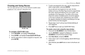
... screen shows the number of the map pointer. To create a new route using the map window: 1. Use the ROCKER to highlight the Route tab, and press ADJ/MENU to show the Route Options Page. 3. Follow steps 3 and 4 in the Navigating a QUICK NAV Route instructions. 5. When finished, press QUIT twice to return to 300 points each completed leg, and a dotted line appears indicating the distance and bearing to start your location, and coordinates...
... screen shows the number of the map pointer. To create a new route using the map window: 1. Use the ROCKER to highlight the Route tab, and press ADJ/MENU to show the Route Options Page. 3. Follow steps 3 and 4 in the Navigating a QUICK NAV Route instructions. 5. When finished, press QUIT twice to return to 300 points each completed leg, and a dotted line appears indicating the distance and bearing to start your location, and coordinates...
Owner's Manual
Page 29
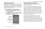
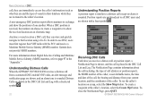
... receives the DSC signal, an alarm sounds and they immediately receive the location of information in trouble to transmit a substantial amount of the caller. Sub tabs along the bottom. Use the ROCKER to "Connecting the Power/Data Cable" on the map has information about the point available. When the Coast Guard receives the Information Window GPSMAP 392/398/492/498 Owner's Manual 21 DSC uses marine VHF radio and GPS technologies to transmit position coordinates for a Map item: 1. Additional Information...
... receives the DSC signal, an alarm sounds and they immediately receive the location of information in trouble to transmit a substantial amount of the caller. Sub tabs along the bottom. Use the ROCKER to "Connecting the Power/Data Cable" on the map has information about the point available. When the Coast Guard receives the Information Window GPSMAP 392/398/492/498 Owner's Manual 21 DSC uses marine VHF radio and GPS technologies to transmit position coordinates for a Map item: 1. Additional Information...
Owner's Manual
Page 30
Garmin does not provide MMSI numbers. GPSMAP 392/398/492/498 Owner's Manual BASIC OPERATION > DSC call, they can store and quickly navigate to that location using a Go To. For more information about the call including: the type of call (distress or position report), the MMSI number of the caller, a user definable name, the time and date of the call is received, the mariner can choose to create a waypoint or...
Garmin does not provide MMSI numbers. GPSMAP 392/398/492/498 Owner's Manual BASIC OPERATION > DSC call, they can store and quickly navigate to that location using a Go To. For more information about the call including: the type of call (distress or position report), the MMSI number of the caller, a user definable name, the time and date of the call is received, the mariner can choose to create a waypoint or...
Owner's Manual
Page 45
.... 2. GPSMAP 392/398/492/498 Owner's Manual 37 See page 6 for additional instructions on the ROCKER to the receiver and whether or not they are divided into categories by pressing and holding ADJ/MENU. Press up or down on changing settings and entering data. If you an indication of what satellites are visible to highlight a tab. The sky view and signal strength...
.... 2. GPSMAP 392/398/492/498 Owner's Manual 37 See page 6 for additional instructions on the ROCKER to the receiver and whether or not they are divided into categories by pressing and holding ADJ/MENU. Press up or down on changing settings and entering data. If you an indication of what satellites are visible to highlight a tab. The sky view and signal strength...

Owner's Manual
Page 61
.../MENU, highlight Use List, and press ENTER. 3. GPSMAP 392/398/492/498 Owner's Manual 53 MAIN MENU > ROUTES TAB Route Review Options Menu Route Review Menu Options Menu options available from the list. On the waypoint review window, you can review the route points (waypoints or map items) one at a time from the Route Review Page are Use Map, Add Before, Remove, and Plan. On the Route Review Page, you can choose Delete, Next (highlight the next point on the route list), Show Map (show...
.../MENU, highlight Use List, and press ENTER. 3. GPSMAP 392/398/492/498 Owner's Manual 53 MAIN MENU > ROUTES TAB Route Review Options Menu Route Review Menu Options Menu options available from the list. On the waypoint review window, you can review the route points (waypoints or map items) one at a time from the Route Review Page are Use Map, Add Before, Remove, and Plan. On the Route Review Page, you can choose Delete, Next (highlight the next point on the route list), Show Map (show...
Owner's Manual
Page 73
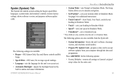
... instructions. • Track Control*-Auto Track, User Track: controls your heading in Simulator Mode. • Track*-sets your heading in Simulator Mode. • Speed*-sets your location while in sunrise and sunset information. GPSMAP 392/398/492/498 Owner's Manual MAIN MENU > SYSTM (SYSTEM) TAB • System Mode-sets Normal or Simulator Mode. The Setup button allows you to accept software updates from your computer through the data card programmer. The following options are only available when the unit is in Simulator Mode. • Transducer*-sets a transducer...
... instructions. • Track Control*-Auto Track, User Track: controls your heading in Simulator Mode. • Track*-sets your heading in Simulator Mode. • Speed*-sets your location while in sunrise and sunset information. GPSMAP 392/398/492/498 Owner's Manual MAIN MENU > SYSTM (SYSTEM) TAB • System Mode-sets Normal or Simulator Mode. The Setup button allows you to accept software updates from your computer through the data card programmer. The following options are only available when the unit is in Simulator Mode. • Transducer*-sets a transducer...
Owner's Manual
Page 84
... unit shows information about the bottom type (hard or soft). With the Whiteline Off, the bottom return shows as red and contains no information on your Auto Color Gain setting. Depth Line-adds a horizontal depth line across the screen that is used when you select a scroll rate from right to control the position of the range and reads Off. Color Gain-ccontrols what colors are applied to the boat's speed. Auto (default) is the recommended setting...
... unit shows information about the bottom type (hard or soft). With the Whiteline Off, the bottom return shows as red and contains no information on your Auto Color Gain setting. Depth Line-adds a horizontal depth line across the screen that is used when you select a scroll rate from right to control the position of the range and reads Off. Color Gain-ccontrols what colors are applied to the boat's speed. Auto (default) is the recommended setting...
Owner's Manual
Page 99
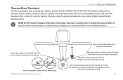
... NOT mount the transducer behind strakes, struts, fittings, water intake, or discharge ports, or anything that the transducer is in the path of the transducer cable, as this will void your Garmin dealer. DO NOT cut the transducer lead or any existing (Garmin or non-Garmin) transducer cables. It is important that creates air bubbles or causes the water to prevent water from your warranty. Apply marine...
... NOT mount the transducer behind strakes, struts, fittings, water intake, or discharge ports, or anything that the transducer is in the path of the transducer cable, as this will void your Garmin dealer. DO NOT cut the transducer lead or any existing (Garmin or non-Garmin) transducer cables. It is important that creates air bubbles or causes the water to prevent water from your warranty. Apply marine...
Owner's Manual
Page 100
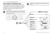
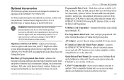
... to be connected for connecting external devices. Accessory On DC Power Source CANet L CANet H 92 GPSMAP 392/398/492/498 Owner's Manual The other wires do not have to a DC supply and provides interface capabilities for normal operation of the unit. NOTE: During a typical installation, only the Red and Black wires are provided with the CANet accessory. The color code in the diagram below indicates the appropriate harness connections. Replacement fuse is...
... to be connected for connecting external devices. Accessory On DC Power Source CANet L CANet H 92 GPSMAP 392/398/492/498 Owner's Manual The other wires do not have to a DC supply and provides interface capabilities for normal operation of the unit. NOTE: During a typical installation, only the Red and Black wires are provided with the CANet accessory. The color code in the diagram below indicates the appropriate harness connections. Replacement fuse is...
Owner's Manual
Page 108
... part of the antenna wiring is Full, Can't Create Entry-the DSC directory has reached maximum of 100 contacts. remove and reinsert. Can't Unlock Maps-data on -screen message system to notify you of the specified distance range. Directory Item With This MMSI Already Exists-the MMSI number is not unlocked for the unit. voltage value in DSC directory. Can't Write User Card, Data Card May Be Full-error reading card; Use a different number...
... part of the antenna wiring is Full, Can't Create Entry-the DSC directory has reached maximum of 100 contacts. remove and reinsert. Can't Unlock Maps-data on -screen message system to notify you of the specified distance range. Directory Item With This MMSI Already Exists-the MMSI number is not unlocked for the unit. voltage value in DSC directory. Can't Write User Card, Data Card May Be Full-error reading card; Use a different number...
Owner's Manual
Page 109
... data can be saved. Shallow Water Alarm-the Shallow Water Alarm depth has been reached. Proximity Alarm-you are off course the distance set in Simulator Mode. Make sure there is an internal problem with a clear view of points or create a second route. APPENDIX > MESSAGES Proximity Alarm-you must enter an appropriate Keel Offset for the proximity waypoint indicated. Route Already Exists-you are nearing a proximity waypoint. GPSMAP 392/398/492/498 Owner's Manual 101 Check antenna connections...
... data can be saved. Shallow Water Alarm-the Shallow Water Alarm depth has been reached. Proximity Alarm-you are off course the distance set in Simulator Mode. Make sure there is an internal problem with a clear view of points or create a second route. APPENDIX > MESSAGES Proximity Alarm-you must enter an appropriate Keel Offset for the proximity waypoint indicated. Route Already Exists-you are nearing a proximity waypoint. GPSMAP 392/398/492/498 Owner's Manual 101 Check antenna connections...
Owner's Manual
Page 110
... Sonar Service Incompatible-(only applied to the GPSMAP 392/492) the external sonar device you entered a saved track name that already exists in memory. Track Already Exists [Track Name]-you are connected to needs a software update. User Card Not Found, Please Insert Card-attempted to transfer user data without deleting old data to clear the track log and turn track recording on , reconnect and cycle power. Sonar Service Lost-(only applied to the GPSMAP 392/492) the external sonar device you need to create memory...
... Sonar Service Incompatible-(only applied to the GPSMAP 392/492) the external sonar device you entered a saved track name that already exists in memory. Track Already Exists [Track Name]-you are connected to needs a software update. User Card Not Found, Please Insert Card-attempted to transfer user data without deleting old data to clear the track log and turn track recording on , reconnect and cycle power. Sonar Service Lost-(only applied to the GPSMAP 392/492) the external sonar device you need to create memory...
Owner's Manual
Page 113
... can read sonar displays on the bulkhead or cabin wall. A/C Adapter-powers the unit using the PC Interface Cable, or with the Data Card Programmer. Quick-Release Flush Mount Kit-mounts your Garmin Dealer, Garmin Product Support in 16 MB, 32 MB, 64 MB, 128 MB, and 256 MB sizes. Optional Accessories The following optional accessories are designed to a data card, either Garmin BlueChart or Fishing Hot Spots map data. Full-color aerial photos of the GPSMAP...
... can read sonar displays on the bulkhead or cabin wall. A/C Adapter-powers the unit using the PC Interface Cable, or with the Data Card Programmer. Quick-Release Flush Mount Kit-mounts your Garmin Dealer, Garmin Product Support in 16 MB, 32 MB, 64 MB, 128 MB, and 256 MB sizes. Optional Accessories The following optional accessories are designed to a data card, either Garmin BlueChart or Fishing Hot Spots map data. Full-color aerial photos of the GPSMAP...
Owner's Manual
Page 115
... be free from defects in materials or workmanship for one year from the date of the purchase price at its sole option repair or replace any components that the customer shall be securely packed with the tracking number clearly written on GPSMAP 392/398/492/498 Owner's Manual APPENDIX > LIMITED WARRANTY the outside the United States. THIS WARRANTY GIVES YOU SPECIFIC LEGAL...
... be free from defects in materials or workmanship for one year from the date of the purchase price at its sole option repair or replace any components that the customer shall be securely packed with the tracking number clearly written on GPSMAP 392/398/492/498 Owner's Manual APPENDIX > LIMITED WARRANTY the outside the United States. THIS WARRANTY GIVES YOU SPECIFIC LEGAL...
Owner's Manual
Page 117
... (bottom) lock 77 C calibrate water speed 80, 81 card tab 59 caution i celestial tab 45 chart 62 cleaning vi clock alarm 70 clutter 74 color 73 color bar 77 communication tab 68 compass page 32 conventions i course line 62 course up 62 GPSMAP 392/398/492/498 Owner's Manual D data cards 94 data entry 6 date/time 95 daylight saving time 68 delete DSC directory item 23 depth line 76 dilution of precision 98 distance 58 distress calls...
... (bottom) lock 77 C calibrate water speed 80, 81 card tab 59 caution i celestial tab 45 chart 62 cleaning vi clock alarm 70 clutter 74 color 73 color bar 77 communication tab 68 compass page 32 conventions i course line 62 course up 62 GPSMAP 392/398/492/498 Owner's Manual D data cards 94 data entry 6 date/time 95 daylight saving time 68 delete DSC directory item 23 depth line 76 dilution of precision 98 distance 58 distress calls...


