Installation Instructions
Page 10
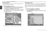
..., and Network Cables: 1. If your GPSMAP 3000 series Owner's Manual for steps on the front of your chartplotter software is not connected to a Garmin Marine Network, be sure to firmly affix the weather cap over the open the Main Menu. 2. For the latest free software updates (excluding map data) throughout the life of the...
..., and Network Cables: 1. If your GPSMAP 3000 series Owner's Manual for steps on the front of your chartplotter software is not connected to a Garmin Marine Network, be sure to firmly affix the weather cap over the open the Main Menu. 2. For the latest free software updates (excluding map data) throughout the life of the...
Owner's Manual
Page 2
...this manual onto a hard drive or other Garmin products. Visit the Garmin Web site (www.garmin.com) for any unauthorized commercial distribution of XM Satellite Radio, Inc. Information in any storage medium, for current updates and supplemental information concerning the use and ... Road, Shijr, Taipei County, Taiwan Tel. 886/2.2642.9199 Fax 886/2.2642.9099 All rights reserved. © Copyright 2007 Garmin Ltd. Garmin®, GPSMAP®, AutoLocate®, TracBack®, BlueChart®, BlueChart® g2™, MapSource®, See-Thru®, DynaColor™, and...
...this manual onto a hard drive or other Garmin products. Visit the Garmin Web site (www.garmin.com) for any unauthorized commercial distribution of XM Satellite Radio, Inc. Information in any storage medium, for current updates and supplemental information concerning the use and ... Road, Shijr, Taipei County, Taiwan Tel. 886/2.2642.9199 Fax 886/2.2642.9099 All rights reserved. © Copyright 2007 Garmin Ltd. Garmin®, GPSMAP®, AutoLocate®, TracBack®, BlueChart®, BlueChart® g2™, MapSource®, See-Thru®, DynaColor™, and...
Owner's Manual
Page 5
...42 Changing the Highway Perspective Range 43 Highway Page Options 43 Video Page...44 Video Page Options 44 Main Menu 45 GPS Tab...45 Tide Tab...46 Tide Sub Tab...46 Current Sub Tab...48 Celestial Tab 49 Trip Tab...50 Weather Tab... of Contents Alarms Tab...58 System Alarms...59 Nav (Navigation) Alarms 59 Sonar Alarms...59 Weather Alarms...60 System Tab...60 Update Sub Tab...65 Network Tab 66 Pages Tab...66 Map Tab...67 AIS Sub Tab...70 Radar Tab...72 Temp (Temperature) ... 82 Sonar Tab...82 General Sub Tab...83 Graph Sub Tab...84 Water Temp Sub Tab 85 GPSMAP 3206/3210 Owner's Manual iii
...42 Changing the Highway Perspective Range 43 Highway Page Options 43 Video Page...44 Video Page Options 44 Main Menu 45 GPS Tab...45 Tide Tab...46 Tide Sub Tab...46 Current Sub Tab...48 Celestial Tab 49 Trip Tab...50 Weather Tab... of Contents Alarms Tab...58 System Alarms...59 Nav (Navigation) Alarms 59 Sonar Alarms...59 Weather Alarms...60 System Tab...60 Update Sub Tab...65 Network Tab 66 Pages Tab...66 Map Tab...67 AIS Sub Tab...70 Radar Tab...72 Temp (Temperature) ... 82 Sonar Tab...82 General Sub Tab...83 Graph Sub Tab...84 Water Temp Sub Tab 85 GPSMAP 3206/3210 Owner's Manual iii
Owner's Manual
Page 26
The Proximity sub tab also provides a continuously updated proximity waypoint alarm that can modify a waypoint by moving or "projecting" the distance and bearing from its present location to a new location. Sub tabs 4. Press ... on the Main Menu has two sub tabs, User and Proximity, which allow you to manage a large number of the Review Waypoint Page. 18 GPSMAP 3206/3210 Owner's Manual Press ENTER to highlight the Points tab, and highlight either the User or Proximity sub tab. Use the ROCKER to accept the new...
The Proximity sub tab also provides a continuously updated proximity waypoint alarm that can modify a waypoint by moving or "projecting" the distance and bearing from its present location to a new location. Sub tabs 4. Press ... on the Main Menu has two sub tabs, User and Proximity, which allow you to manage a large number of the Review Waypoint Page. 18 GPSMAP 3206/3210 Owner's Manual Press ENTER to highlight the Points tab, and highlight either the User or Proximity sub tab. Use the ROCKER to accept the new...
Owner's Manual
Page 55
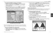
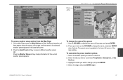
...to change the date of Tide Stations near the selected map location. 4. The distance and bearing from your location: 1. Highlight the tide chart. 2. GPSMAP 3206/3210 Owner's Manual 47 Using the ROCKER, highlight the On field, and press ENTER. 2. Press the Current Date soft key to a map location, ... ENTER to open the Find Tides Page. 2. To select a Tide Station from the list, and press ENTER. The tide chart is updated to show tide information for other days or move the highlight over each Tide Station in approximately five minute increments to show tide heights at...
...to change the date of Tide Stations near the selected map location. 4. The distance and bearing from your location: 1. Highlight the tide chart. 2. GPSMAP 3206/3210 Owner's Manual 47 Using the ROCKER, highlight the On field, and press ENTER. 2. Press the Current Date soft key to a map location, ... ENTER to open the Find Tides Page. 2. To select a Tide Station from the list, and press ENTER. The tide chart is updated to show tide information for other days or move the highlight over each Tide Station in approximately five minute increments to show tide heights at...

Owner's Manual
Page 59
...waypoints appears at the bottom of the User sub tab, with the stored waypoints arranged in memory. The sub tabs also provide continuously updated proximity waypoint alarms that you to manage a large number of all user waypoints. The Weather tab appears only if you can use ... remaining Number of used to customize preset weather options. From the User list, you have a GDL30/GDL 30A Marine Weather/Audio Satellite Receiver installed and connected to your GPSMAP 3206/3210, and a subscription to XM WX Satellite Weather to use to define items, such as submerged hazards or shallow ...
...waypoints appears at the bottom of the User sub tab, with the stored waypoints arranged in memory. The sub tabs also provide continuously updated proximity waypoint alarms that you to manage a large number of all user waypoints. The Weather tab appears only if you can use ... remaining Number of used to customize preset weather options. From the User list, you have a GDL30/GDL 30A Marine Weather/Audio Satellite Receiver installed and connected to your GPSMAP 3206/3210, and a subscription to XM WX Satellite Weather to use to define items, such as submerged hazards or shallow ...
Owner's Manual
Page 68
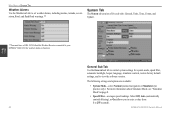
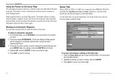
...Weather sub tab to function. Main Menu **You must have a GDL 30/30A Satellite Weather Receiver connected to your GPSMAP 3206/3210 for weather alarms to set weather alarms, including marine, tornado, severe storm, flood, and flash flood warnings.** System Tab The System tab consists of... five sub tabs: General, Units, Time, Comm, and Update. Select Off, Auto (automatically controls filtering), or On (...
...Weather sub tab to function. Main Menu **You must have a GDL 30/30A Satellite Weather Receiver connected to your GPSMAP 3206/3210 for weather alarms to set weather alarms, including marine, tornado, severe storm, flood, and flash flood warnings.** System Tab The System tab consists of... five sub tabs: General, Units, Time, Comm, and Update. Select Off, Auto (automatically controls filtering), or On (...
Owner's Manual
Page 69
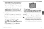
... should be shown somewhere on the GPSMAP 3206/3210. Main Menu • Automatic Backlight-automatically adjusts the display brightness to Garmin's original setup values for all devices... on the network. • System Info-shows the unit's software, basemap version, and electronic serial number. • Update... new device is added, you are using a map or chart with your GPS, make sure the settings on -screen text. • Services-after sunset...
... should be shown somewhere on the GPSMAP 3206/3210. Main Menu • Automatic Backlight-automatically adjusts the display brightness to Garmin's original setup values for all devices... on the network. • System Info-shows the unit's software, basemap version, and electronic serial number. • Update... new device is added, you are using a map or chart with your GPS, make sure the settings on -screen text. • Services-after sunset...

Owner's Manual
Page 71
... can result in substantial differences between the information displayed on wiring and NMEA information. Failure to update this setting, the GPSMAP 3206/3210 unit does not automatically calculate and update the magnetic variation at your location changes. Enter the magnetic variation at your unit and external references... Time Format-select 12 Hour, 24 Hour (military), or UTC (also called Greenwich Time) time format. • Time Zone-select your GPSMAP 3206/3210 to external NMEA devices or a personal computer. Time Sub Tab Use the Time sub tab to adjust the time format, enter a time ...
... can result in substantial differences between the information displayed on wiring and NMEA information. Failure to update this setting, the GPSMAP 3206/3210 unit does not automatically calculate and update the magnetic variation at your location changes. Enter the magnetic variation at your unit and external references... Time Format-select 12 Hour, 24 Hour (military), or UTC (also called Greenwich Time) time format. • Time Zone-select your GPSMAP 3206/3210 to external NMEA devices or a personal computer. Time Sub Tab Use the Time sub tab to adjust the time format, enter a time ...
Owner's Manual
Page 73
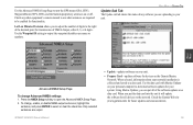
.../Lon Minutes Precision allows you are uploading to your network installation is collected and saved to a data card. GPSMAP 3206/3210 Owner's Manual • Update-updates software on your system. Check any software you to adjust the number of digits to the right of the ...software updates for your unit. • Prepare Card-updates software for functionality. Using Marine Updater, you put all devices on the Garmin Marine Network. Check the Garmin Web site (www.garmin.com) for all of NMEA Output, either 2, 3, or 4 digits. Use the Advanced NMEA Setup Page to turn the GPS status...
.../Lon Minutes Precision allows you are uploading to your network installation is collected and saved to a data card. GPSMAP 3206/3210 Owner's Manual • Update-updates software on your system. Check any software you to adjust the number of digits to the right of the ...software updates for your unit. • Prepare Card-updates software for functionality. Using Marine Updater, you put all devices on the Garmin Marine Network. Check the Garmin Web site (www.garmin.com) for all of NMEA Output, either 2, 3, or 4 digits. Use the Advanced NMEA Setup Page to turn the GPS status...
Owner's Manual
Page 90
... Discontinuity is possible from where the sonar information stops and where it easier to find and use the ROCKER to move the pointer to update while the display is automatically selected. 2. Make any new sonar data until the Sonar Page resumes scrolling. Press the Sonar Setup soft key... to set up the Sonar Page. To change a setting on the Main Menu. Sonar 82 GPSMAP 3206/3210 Owner's Manual To mark an underwater waypoint: 1. The Review Waypoint Page appears with the waypoint's coordinates, default name, and pointer depth automatically...
... Discontinuity is possible from where the sonar information stops and where it easier to find and use the ROCKER to move the pointer to update while the display is automatically selected. 2. Make any new sonar data until the Sonar Page resumes scrolling. Press the Sonar Setup soft key... to set up the Sonar Page. To change a setting on the Main Menu. Sonar 82 GPSMAP 3206/3210 Owner's Manual To mark an underwater waypoint: 1. The Review Waypoint Page appears with the waypoint's coordinates, default name, and pointer depth automatically...
Owner's Manual
Page 95
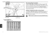
...the preset, and press ENTER. 2. To customize the preset weather options: 1. Select the range, and press ENTER again. The preset name is updated in the lower-left corner of the map window. Select the weather preset you want to change , and press ENTER. 4. OR Press the Weather...information for the current weather preset appears. Press the Next Preset soft key to change the name, and press ENTER when finished. GPSMAP 3206/3210 Owner's Manual 87 Preset name XM WX Weather > Customizing Preset Weather Displays Weather To access weather setup options from the Map Page: 1.
...the preset, and press ENTER. 2. To customize the preset weather options: 1. Select the range, and press ENTER again. The preset name is updated in the lower-left corner of the map window. Select the weather preset you want to change , and press ENTER. 4. OR Press the Weather...information for the current weather preset appears. Press the Next Preset soft key to change the name, and press ENTER when finished. GPSMAP 3206/3210 Owner's Manual 87 Preset name XM WX Weather > Customizing Preset Weather Displays Weather To access weather setup options from the Map Page: 1.

Owner's Manual
Page 99
...Radar > Radar Page Configuring the Radar Page You can customize the appearance of the page. Radar Page GPSMAP 3206/3210 Owner's Manual 91 See "Configuring Main Pages" on the Radar Page: 1. Open the Radar Page,...radar. Radar 2. If the message "Incompatible Software Version" appears when you turn on the GPSMAP 3206/3210, you must update your GPSMAP 3206/3210, it should detect the radar as a new network connection. When the new radar is detected...radar properly installed, when you turn on your GPSMAP 3206/3210 software. Note: A software update may be needed for more information.
...Radar > Radar Page Configuring the Radar Page You can customize the appearance of the page. Radar Page GPSMAP 3206/3210 Owner's Manual 91 See "Configuring Main Pages" on the Radar Page: 1. Open the Radar Page,...radar. Radar 2. If the message "Incompatible Software Version" appears when you turn on the GPSMAP 3206/3210, you must update your GPSMAP 3206/3210, it should detect the radar as a new network connection. When the new radar is detected...radar properly installed, when you turn on your GPSMAP 3206/3210 software. Note: A software update may be needed for more information.
Owner's Manual
Page 104
...place the radar into Standby Mode. Note: This option is transmitting. After the radar completes "Spinning Up", the radar begins transmitting. Radar 96 GPSMAP 3206/3210 Owner's Manual Set Motor to High Speed (Set Motor to Normal Speed) The Set Motor to High Speed (Set Motor to increases the ...speed at which the radar rotates, thus increasing the speed at which the screen updates. Using Radar > Radar Page Safe targets Acquiring target To view...
...place the radar into Standby Mode. Note: This option is transmitting. After the radar completes "Spinning Up", the radar begins transmitting. Radar 96 GPSMAP 3206/3210 Owner's Manual Set Motor to High Speed (Set Motor to Normal Speed) The Set Motor to High Speed (Set Motor to increases the ...speed at which the radar rotates, thus increasing the speed at which the screen updates. Using Radar > Radar Page Safe targets Acquiring target To view...
Owner's Manual
Page 109
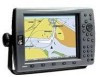
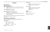
...: GPSMAP 3206: 3.0 lbs (1.4 kg) GPSMAP 3210: 5.0 lbs (2.3 kg) Display: GPSMAP 3206: 6.4" diagonal (16.3 cm) GPSMAP 3210: 10.4" diagonal (26.4 cm) High resolution, 256-color TFT (640 x 480 pixels), full VGA, with GPS 17) Receiver: Differential-ready 12 parallel channel WAAS-capable receiver Acquisition Times: • Warm: Approx. 15 seconds • Cold: Approx. 45 seconds • AutoLocate: Approx. 2 minutes Update Rate...
...: GPSMAP 3206: 3.0 lbs (1.4 kg) GPSMAP 3210: 5.0 lbs (2.3 kg) Display: GPSMAP 3206: 6.4" diagonal (16.3 cm) GPSMAP 3210: 10.4" diagonal (26.4 cm) High resolution, 256-color TFT (640 x 480 pixels), full VGA, with GPS 17) Receiver: Differential-ready 12 parallel channel WAAS-capable receiver Acquisition Times: • Warm: Approx. 15 seconds • Cold: Approx. 45 seconds • AutoLocate: Approx. 2 minutes Update Rate...
Owner's Manual
Page 119
... or the transducer cable was disconnected. Contact your dealer or Garmin Product Support to have used all 4,000 waypoints available. Track...: -you exceeded the specified off-course distance. Appendix GPSMAP 3206/3210 Owner's Manual 111 Delete unwanted waypoints to make space ...for the proximity waypoint indicated. Route Truncated-an uploaded route from another proximity waypoint. Route Waypoint Memory Full-no additional routes can be added until existing ones are connected to needs a software update...
... or the transducer cable was disconnected. Contact your dealer or Garmin Product Support to have used all 4,000 waypoints available. Track...: -you exceeded the specified off-course distance. Appendix GPSMAP 3206/3210 Owner's Manual 111 Delete unwanted waypoints to make space ...for the proximity waypoint indicated. Route Truncated-an uploaded route from another proximity waypoint. Route Waypoint Memory Full-no additional routes can be added until existing ones are connected to needs a software update...
Owner's Manual
Page 126
...68 Map Page 36-39 map pointer 11 map ranges 38 MapSource 57, 102 Map tab 67-71 marine bulletins 88 marine remote control 3 Maritime Mobile Service Identity. See MMSI MARPA 92, 95-96 MARPA sub tab 97,... control 8 skyview orientation 7 soft keys 10, 90 soft structure 77 software license agreement v software update 91 software version 61 Sonar 76-85 GPSMAP 3206/3210 Owner's Manual PA MMSI number 105 MOB 25 moon phase 49 moon rise/set 49 N narrow ... clutter 92 RANGE keys 2 range rings 90 re-evaluate route 27 receiver status 7 replace from card 57 messages 110 Mini Automatic Radar Plotting Aid.
...68 Map Page 36-39 map pointer 11 map ranges 38 MapSource 57, 102 Map tab 67-71 marine bulletins 88 marine remote control 3 Maritime Mobile Service Identity. See MMSI MARPA 92, 95-96 MARPA sub tab 97,... control 8 skyview orientation 7 soft keys 10, 90 soft structure 77 software license agreement v software update 91 software version 61 Sonar 76-85 GPSMAP 3206/3210 Owner's Manual PA MMSI number 105 MOB 25 moon phase 49 moon rise/set 49 N narrow ... clutter 92 RANGE keys 2 range rings 90 re-evaluate route 27 receiver status 7 replace from card 57 messages 110 Mini Automatic Radar Plotting Aid.
Owner's Manual
Page 130
For the latest free software updates (excluding map data) throughout the life of your Garmin products, visit the Garmin Web site at www.garmin.com. © 2007 Garmin Ltd. E Liberty House, Hounsdown Business Park, Southampton, Hampshire, SO40 9RB UK Garmin Corporation No. 68, Jangshu 2nd Road, Shijr, Taipei County, Taiwan www.garmin.com Part Number 190-00593-00 Rev. or its subsidiaries Garmin International, Inc. 1200 East 151st Street, Olathe, Kansas 66062, USA Garmin (Europe) Ltd.
For the latest free software updates (excluding map data) throughout the life of your Garmin products, visit the Garmin Web site at www.garmin.com. © 2007 Garmin Ltd. E Liberty House, Hounsdown Business Park, Southampton, Hampshire, SO40 9RB UK Garmin Corporation No. 68, Jangshu 2nd Road, Shijr, Taipei County, Taiwan www.garmin.com Part Number 190-00593-00 Rev. or its subsidiaries Garmin International, Inc. 1200 East 151st Street, Olathe, Kansas 66062, USA Garmin (Europe) Ltd.

