
Pilot's Guide
Page 5
Marine Mode Pages and Features 88 Map Page 88 Compass Page 89 DSC Page 91 Main Menu 96 GPS Tab 96 Flights Tab 97 Route Tab 97 Points Tab 97 Track Tab 98 Sonar Tab 98 Aircraft Tab 99 Alarms Tab 99 Calendar Tab ... 128 Viewing the Sonar Temperature Tab 131 GPSMAP 296 Pilot's Guide INTRODUCTION > TABLE OF CONTENTS Appendix 132 Specifications 132 Optional Accessories 133 Installation Information 134 Learning About GPS 138 LORAN TD Setup 140 Map Datums and Location Formats 142 Digital Selective Calling (DSC 143 Jeppesen Database Information 145 Messages 146 Data Field...
Marine Mode Pages and Features 88 Map Page 88 Compass Page 89 DSC Page 91 Main Menu 96 GPS Tab 96 Flights Tab 97 Route Tab 97 Points Tab 97 Track Tab 98 Sonar Tab 98 Aircraft Tab 99 Alarms Tab 99 Calendar Tab ... 128 Viewing the Sonar Temperature Tab 131 GPSMAP 296 Pilot's Guide INTRODUCTION > TABLE OF CONTENTS Appendix 132 Specifications 132 Optional Accessories 133 Installation Information 134 Learning About GPS 138 LORAN TD Setup 140 Map Datums and Location Formats 142 Digital Selective Calling (DSC 143 Jeppesen Database Information 145 Messages 146 Data Field...
Pilot's Guide
Page 9
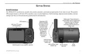
... shown here) to provide you with backlighting Backlit keypad for easy nighttime operation Detachable GPS antenna collapses for air, land, or water. See the "Warning" section on removing the antenna. GETTING STARTED GETTING STARTED > UNIT OVERVIEW Unit Overview The GPSMAP 296 is an all-in basemap, Jeppesen aviation database, and auto routing to receive satellite signals.
... shown here) to provide you with backlighting Backlit keypad for easy nighttime operation Detachable GPS antenna collapses for air, land, or water. See the "Warning" section on removing the antenna. GETTING STARTED GETTING STARTED > UNIT OVERVIEW Unit Overview The GPSMAP 296 is an all-in basemap, Jeppesen aviation database, and auto routing to receive satellite signals.
Pilot's Guide
Page 18
...next character or press left once more information. GPSMAP 296 Databases Your GPSMAP 296 comes with fields that are on the ROCKER to page 145 in a data field: 1. MapSource Detailed Maps Optional Garmin Data Cards and MapSource CD-ROMs enhance the versatility...the Garmin Web site at http://www.garmin.com/cartography/ 10 GPSMAP 296 Pilot's Guide GETTING STARTED > USING THE GPSMAP 296 To enter data in the "Appendix" for any listed location. Press up or down on a page with a Jeppesen® database, an Obstacle database, a Terrain database, a Voice Guidance database, and...
...next character or press left once more information. GPSMAP 296 Databases Your GPSMAP 296 comes with fields that are on the ROCKER to page 145 in a data field: 1. MapSource Detailed Maps Optional Garmin Data Cards and MapSource CD-ROMs enhance the versatility...the Garmin Web site at http://www.garmin.com/cartography/ 10 GPSMAP 296 Pilot's Guide GETTING STARTED > USING THE GPSMAP 296 To enter data in the "Appendix" for any listed location. Press up or down on a page with a Jeppesen® database, an Obstacle database, a Terrain database, a Voice Guidance database, and...

Pilot's Guide
Page 22
..., Find Land Points, and Remove Point. Based on any tab of the Go To Page to that point. As you scroll through the characters the GPSMAP 296 shows database entries with the same characters you have entered to open an options menu for . Use ENTER and the ROCKER to select a destination. Also, in... the point is currently in Marine Mode, pressing Direct To twice creates a MOB waypoint and starts navigating to search for that point. Go To Page: Aviation Tab 14 GPSMAP 296 Pilot's Guide The GPSMAP 296 creates a course from your present location to an airport or navaid: 1.
..., Find Land Points, and Remove Point. Based on any tab of the Go To Page to that point. As you scroll through the characters the GPSMAP 296 shows database entries with the same characters you have entered to open an options menu for . Use ENTER and the ROCKER to select a destination. Also, in... the point is currently in Marine Mode, pressing Direct To twice creates a MOB waypoint and starts navigating to search for that point. Go To Page: Aviation Tab 14 GPSMAP 296 Pilot's Guide The GPSMAP 296 creates a course from your present location to an airport or navaid: 1.
Pilot's Guide
Page 30
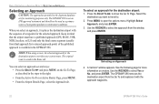
... approach (GPS, RNAV, VOR, NDB, localizer, or ILS) and only the final course segment (usually from final approach fix to select the approach from the Go To and replaces it replaces the destination airport with the approach waypoints. 22 GPSMAP 296 Pilot's ...Select Approach, and press ENTER. 3. The original route is available in the GPSMAP 296. BASIC OPERATION IN AVIATION MODE > SELECTING AN APPROACH Selecting an Approach CAUTION: The approaches provided in the Jeppesen database are for the selected approach. You can select an approach several ways: •...
... approach (GPS, RNAV, VOR, NDB, localizer, or ILS) and only the final course segment (usually from final approach fix to select the approach from the Go To and replaces it replaces the destination airport with the approach waypoints. 22 GPSMAP 296 Pilot's ...Select Approach, and press ENTER. 3. The original route is available in the GPSMAP 296. BASIC OPERATION IN AVIATION MODE > SELECTING AN APPROACH Selecting an Approach CAUTION: The approaches provided in the Jeppesen database are for the selected approach. You can select an approach several ways: •...

Pilot's Guide
Page 31
Active Approach Page Using vectors in the database (final approach fix [FAF]). The Map Page shows an extension of the final course, beyond the final approach waypoint in the approach The GPSMAP 296 provides no guidance to the inbound course. If you enabled .... Understanding Vectors The Vectors? On the Active Route Page, a Vector to show the direction) to cancel the entire approach. GPSMAP 296 Pilot's Guide BASIC OPERATION IN AVIATION MODE > SELECTING AN APPROACH If No is selected for the Vectors? You can cancel an approach and/or vectors several ways...
Active Approach Page Using vectors in the database (final approach fix [FAF]). The Map Page shows an extension of the final course, beyond the final approach waypoint in the approach The GPSMAP 296 provides no guidance to the inbound course. If you enabled .... Understanding Vectors The Vectors? On the Active Route Page, a Vector to show the direction) to cancel the entire approach. GPSMAP 296 Pilot's Guide BASIC OPERATION IN AVIATION MODE > SELECTING AN APPROACH If No is selected for the Vectors? You can cancel an approach and/or vectors several ways...

Pilot's Guide
Page 34
...future use at a later time. If there is an obsolete Jeppesen aviation point in a saved route, the route is then saved for immediate use. Press MENU to create a new route with current Jeppesen Database points. Use the ROCKER to show the options menu. Highlight Activate ... The selected point is automatically saved to "Creating Routes" beginning on page 56 and "Editing and Managing Routes" beginning on page 69. 26 GPSMAP 296 Pilot's Guide To navigate a saved route: 1. Use the ROCKER to continue adding waypoints. 7. Highlight the route you want to open the Main...
...future use at a later time. If there is an obsolete Jeppesen aviation point in a saved route, the route is then saved for immediate use. Press MENU to create a new route with current Jeppesen Database points. Use the ROCKER to show the options menu. Highlight Activate ... The selected point is automatically saved to "Creating Routes" beginning on page 56 and "Editing and Managing Routes" beginning on page 69. 26 GPSMAP 296 Pilot's Guide To navigate a saved route: 1. Use the ROCKER to continue adding waypoints. 7. Highlight the route you want to open the Main...

Pilot's Guide
Page 35
... started your flight plan (or route), the GPSMAP 296 guides you to the course, and other information such as speed, altitude, and ETA. GPSMAP 296 Pilot's Guide 27 View the HSI on the magenta line, you are shown in Aviation Mode). For complete information about the Map Page and ...the features of the magenta line as an airplane (when in red. Adjust your Jeppesen Database, verify that might become a...
... started your flight plan (or route), the GPSMAP 296 guides you to the course, and other information such as speed, altitude, and ETA. GPSMAP 296 Pilot's Guide 27 View the HSI on the magenta line, you are shown in Aviation Mode). For complete information about the Map Page and ...the features of the magenta line as an airplane (when in red. Adjust your Jeppesen Database, verify that might become a...

Pilot's Guide
Page 37
Select Set up Map, and press ENTER. The map range is controlled by both the internal database and data card map information, the cartography with the best resolution is shown. • When the selected zoom range exceeds the resolution of the data ... to 800 mi or 5 m to 1200 km). Using detailed maps loaded on the data card GPSMAP 296 Pilot's Guide 29 Refer to zoom in worldwide database to open the Map Page. Zooming In and Out of the destination. AVIATION MODE PAGES > MAP PAGE Map coverage conforms to the following conditions: • Cartography is shown...
Select Set up Map, and press ENTER. The map range is controlled by both the internal database and data card map information, the cartography with the best resolution is shown. • When the selected zoom range exceeds the resolution of the data ... to 800 mi or 5 m to 1200 km). Using detailed maps loaded on the data card GPSMAP 296 Pilot's Guide 29 Refer to zoom in worldwide database to open the Map Page. Zooming In and Out of the destination. AVIATION MODE PAGES > MAP PAGE Map coverage conforms to the following conditions: • Cartography is shown...

Pilot's Guide
Page 50
.... AVIATION MODE PAGES > PANEL PAGE VNAV Indicator Panel Page showing the VNAV Indicator VNAV indicators also appear on the Map Page when the page layout is set a target location at the proper altitude for airports in the Jeppesen database or Above MSL to a destination. VNAV Waypoint-allows you reach your reference waypoint. GPSMAP 296...
.... AVIATION MODE PAGES > PANEL PAGE VNAV Indicator Panel Page showing the VNAV Indicator VNAV indicators also appear on the Map Page when the page layout is set a target location at the proper altitude for airports in the Jeppesen database or Above MSL to a destination. VNAV Waypoint-allows you reach your reference waypoint. GPSMAP 296...

Pilot's Guide
Page 51
... select an approach and add the waypoints to create a new route with current Jeppesen Database points. GPSMAP 296 Pilot's Guide 43 Active Route Page Whenever you start a route (flight plan) or initiate a Go To while in Aviation or Marine Mode, the Active Route Page shows each point (waypoint or map item... the Go To or route must be an airport with the sequence of the same features and options. All approach procedures are based on existing GPS, RNAV, VOR, NDB, localizer, or ILS approach procedures. You need to the route, the final destination in a Go To or route ...
... select an approach and add the waypoints to create a new route with current Jeppesen Database points. GPSMAP 296 Pilot's Guide 43 Active Route Page Whenever you start a route (flight plan) or initiate a Go To while in Aviation or Marine Mode, the Active Route Page shows each point (waypoint or map item... the Go To or route must be an airport with the sequence of the same features and options. All approach procedures are based on existing GPS, RNAV, VOR, NDB, localizer, or ILS approach procedures. You need to the route, the final destination in a Go To or route ...
Pilot's Guide
Page 99
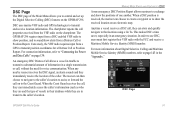
... the GPSMAP 296. For connection information, refer to transmit a substantial amount of one another. An emergency DSC Distress Call allows a vessel in transit to show alerts from a GPS to the Coast Guard. In order to use DSC, users must first register their database while... For more information about Digital Selective Calling and Maritime Mobile Service Identity (MMSI) numbers, refer to sound/show the received location on page 134. DSC Page GPSMAP 296 Pilot's Guide 91 Conversely, the VHF radio requires input from a Distress Call or Position Report. This makes DSC...
... the GPSMAP 296. For connection information, refer to transmit a substantial amount of one another. An emergency DSC Distress Call allows a vessel in transit to show alerts from a GPS to the Coast Guard. In order to use DSC, users must first register their database while... For more information about Digital Selective Calling and Maritime Mobile Service Identity (MMSI) numbers, refer to sound/show the received location on page 134. DSC Page GPSMAP 296 Pilot's Guide 91 Conversely, the VHF radio requires input from a Distress Call or Position Report. This makes DSC...

Pilot's Guide
Page 151
...GPS) technologies to act like a phone number when used in a Position Report and as who they are in transit to assist them in a single transmission or "call , they are and the type of one another. APPENDIX > DIGITAL SELECTIVE CALLING (DSC) Any time a vessel receives a DSC call ," without the need for voice communication. Garmin.... What is used by mariners to the caller's location. GPSMAP 296 Pilot's Guide 143 When any nearby rescuer receives the DSC signal, an alarm sounds and they immediately receive the location of information in two major areas: Distress Calls ...
...GPS) technologies to act like a phone number when used in a Position Report and as who they are in transit to assist them in a single transmission or "call , they are and the type of one another. APPENDIX > DIGITAL SELECTIVE CALLING (DSC) Any time a vessel receives a DSC call ," without the need for voice communication. Garmin.... What is used by mariners to the caller's location. GPSMAP 296 Pilot's Guide 143 When any nearby rescuer receives the DSC signal, an alarm sounds and they immediately receive the location of information in two major areas: Distress Calls ...

Pilot's Guide
Page 153
.... FSS-Flight Service Stations. * Symbology used for thousands of your flight record keeping. GPSMAP 296 Pilot's Guide APPENDIX > JEPPESEN DATABASE INFORMATION ARTCC-Air Route Traffic Control Centers. Visit the Garmin Web site at http://www.garmin.com/aviation. 145 If there is locked and unusable. Intersections-identifier, nearest VOR, radial and distance...
.... FSS-Flight Service Stations. * Symbology used for thousands of your flight record keeping. GPSMAP 296 Pilot's Guide APPENDIX > JEPPESEN DATABASE INFORMATION ARTCC-Air Route Traffic Control Centers. Visit the Garmin Web site at http://www.garmin.com/aviation. 145 If there is locked and unusable. Intersections-identifier, nearest VOR, radial and distance...

Pilot's Guide
Page 154
...decent point. Select a different destination. 146 GPSMAP 296 Pilot's Guide Alarm Clock-the alarm clock ...received. Take appropriate action. The unit shows an icon and beeps (if enabled). Contact Garmin Product Support to provide a valid speed. Memory Full-unit memory is Below Transducer-no further data can be recharged. Contact Garmin Product Support to Ground-the external GPS... antenna has an electrical connection problem. Contact Garmin ...Reception-the unit is not receiving DGPS data. No Diff GPS Location-RTCM is selected, but...
...decent point. Select a different destination. 146 GPSMAP 296 Pilot's Guide Alarm Clock-the alarm clock ...received. Take appropriate action. The unit shows an icon and beeps (if enabled). Contact Garmin Product Support to provide a valid speed. Memory Full-unit memory is Below Transducer-no further data can be recharged. Contact Garmin Product Support to Ground-the external GPS... antenna has an electrical connection problem. Contact Garmin ...Reception-the unit is not receiving DGPS data. No Diff GPS Location-RTCM is selected, but...
Pilot's Guide
Page 163
...Database 26, 146 Updates 10 K Keypad 7 L Land at Closest Point 18 Language 110 Legs, Track 85 Limited Warranty 152 Lithium-ion 1, 2 Local Time 113 Location 6, 60 Location Format 114, 143 Locked Route 26 Log Filter 107 Longitude 149 LORAN TD Setup 141-142 Lost Satellite Reception 5 GPSMAP 296... Pilot's Guide M Magnetic Variation 115 Main Menu Display Tab 108 GPS tab 4 Sound Tab 109 Managing Routes 69 ... Options Menu 9 Overzoom 29 P Page Layout 34 Page Sequence 86 Panel Page Aviation Mode 39-42 Panning the Map 28, 30 Pan Mode 28, 30 PC ...
...Database 26, 146 Updates 10 K Keypad 7 L Land at Closest Point 18 Language 110 Legs, Track 85 Limited Warranty 152 Lithium-ion 1, 2 Local Time 113 Location 6, 60 Location Format 114, 143 Locked Route 26 Log Filter 107 Longitude 149 LORAN TD Setup 141-142 Lost Satellite Reception 5 GPSMAP 296... Pilot's Guide M Magnetic Variation 115 Main Menu Display Tab 108 GPS tab 4 Sound Tab 109 Managing Routes 69 ... Options Menu 9 Overzoom 29 P Page Layout 34 Page Sequence 86 Panel Page Aviation Mode 39-42 Panning the Map 28, 30 Pan Mode 28, 30 PC ...

Pilot's Guide
Page 165
..., 102 True Airspeed 49 Tuning Beacon 140 Turn-by-Turn Route 51, 61, 70 Turn On and Off 3 GPSMAP 296 Pilot's Guide U Underwater Waypoints 124 Units Tab 114 Unpaved Roads 112 Updates to Jeppesen Database 146 Usage Mode 13, 110 Usage Restrictions 16 USB 116 Data Cable 136 User Points Tab 78 UTC...
..., 102 True Airspeed 49 Tuning Beacon 140 Turn-by-Turn Route 51, 61, 70 Turn On and Off 3 GPSMAP 296 Pilot's Guide U Underwater Waypoints 124 Units Tab 114 Unpaved Roads 112 Updates to Jeppesen Database 146 Usage Mode 13, 110 Usage Restrictions 16 USB 116 Data Cable 136 User Points Tab 78 UTC...
