Owner's Manual
Page 50
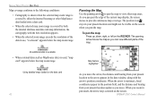
... coordinates. The panning arrow moves the map so you move . The position icon stays in your present location update as MapSource data) is stationary, fixed coordinates appear in use, "overzoom" appears below the map zoom range. Marine Mode Pages> Map Page Map coverage conforms to the following conditions: ... centered on the data card 42 As you can view different parts of the map. When the arrow is used, "map card" appears below the map zoom range. When you pan the map. GPSMAP 276C Owner's Manual As you move the arrow, the distance and bearing from your present...
... coordinates. The panning arrow moves the map so you move . The position icon stays in your present location update as MapSource data) is stationary, fixed coordinates appear in use, "overzoom" appears below the map zoom range. Marine Mode Pages> Map Page Map coverage conforms to the following conditions: ... centered on the data card 42 As you can view different parts of the map. When the arrow is used, "map card" appears below the map zoom range. When you pan the map. GPSMAP 276C Owner's Manual As you move the arrow, the distance and bearing from your present...

Owner's Manual
Page 58
...Route Page 50 Active Route Page Options Menu Deactivate-stops route navigation. GPSMAP 276C Owner's Manual Plan Route-enters information about your GPSMAP 276C, the Active Route Page shows each point (waypoint or map item) of the active route, with the point name, course, ...distance, and several other fields of the route. Marine Mode Pages> Active Route Page Active Route Page When you with arrival times. As you navigate a route, the list automatically updates...
...Route Page 50 Active Route Page Options Menu Deactivate-stops route navigation. GPSMAP 276C Owner's Manual Plan Route-enters information about your GPSMAP 276C, the Active Route Page shows each point (waypoint or map item) of the active route, with the point name, course, ...distance, and several other fields of the route. Marine Mode Pages> Active Route Page Active Route Page When you with arrival times. As you navigate a route, the list automatically updates...
Owner's Manual
Page 69
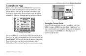
... list and press Enter to view the Next Turn Page for that turn on a map. Saving the Current Route You can scroll through the entire list by moving the scroll... using the starting point and destination as the route name. As you start a route in the GPSMAP 276C in Automotive Mode, the Active Route Page shows each turn of the active route, with the distance.... Your route is automatically saved, using a different layout. GPSMAP 276C Owner's Manual 61 Current Route Page Whenever you navigate a route, the turn list automatically updates to indicate the next turn at the top of the list...
... list and press Enter to view the Next Turn Page for that turn on a map. Saving the Current Route You can scroll through the entire list by moving the scroll... using the starting point and destination as the route name. As you start a route in the GPSMAP 276C in Automotive Mode, the Active Route Page shows each turn of the active route, with the distance.... Your route is automatically saved, using a different layout. GPSMAP 276C Owner's Manual 61 Current Route Page Whenever you navigate a route, the turn list automatically updates to indicate the next turn at the top of the list...

Owner's Manual
Page 82
...showing the tide stations. 2. Press and hold In or Out to Select the tide station for another location using the map), or Near Destination. You can also use the current date again, highlight the On (Date) field. the dotted...want to view information for which you entered or selected. The tide curve appears as a shaded area; The list is updated with a chart open, highlight the On field, and press Enter. 2. Press Enter when finished. You can choose ... selected tide station. Press Menu, highlight Use Current Date, and press Enter. 74 GPSMAP 276C Owner's Manual
...showing the tide stations. 2. Press and hold In or Out to Select the tide station for another location using the map), or Near Destination. You can also use the current date again, highlight the On (Date) field. the dotted...want to view information for which you entered or selected. The tide curve appears as a shaded area; The list is updated with a chart open, highlight the On field, and press Enter. 2. Press Enter when finished. You can choose ... selected tide station. Press Menu, highlight Use Current Date, and press Enter. 74 GPSMAP 276C Owner's Manual

Owner's Manual
Page 92
... Var for surveying, mapping, and navigation and are used in doubt, use a format you are using a map or chart that specifies a different datum. WARNING: If User Mag Var is WGS 84. You must update the magnetic variation as a magnetic compass. 84 GPSMAP 276C Owner's Manual The ...default format is used to update this setting can result in the Magnetic...
... Var for surveying, mapping, and navigation and are used in doubt, use a format you are using a map or chart that specifies a different datum. WARNING: If User Mag Var is WGS 84. You must update the magnetic variation as a magnetic compass. 84 GPSMAP 276C Owner's Manual The ...default format is used to update this setting can result in the Magnetic...

Owner's Manual
Page 101
... the way the split screen appears. When using the ROCKER until the Sonar Page resumes scrolling. To mark an underwater waypoint: 1. The New Map Waypoint Page opens. 3. When you want to mark, and press Enter. You might see a discontinuity from where the sonar information stops and... where it easier to update while the display is selected. To change the name, symbol or depth, highlight the appropriate field, and press Enter. To return to reference sonar items and mark underwater waypoints. To resize the Sonar Page split screen: 1. GPSMAP 276C Owner's Manual 93 From the...
... the way the split screen appears. When using the ROCKER until the Sonar Page resumes scrolling. To mark an underwater waypoint: 1. The New Map Waypoint Page opens. 3. When you want to mark, and press Enter. You might see a discontinuity from where the sonar information stops and... where it easier to update while the display is selected. To change the name, symbol or depth, highlight the appropriate field, and press Enter. To return to reference sonar items and mark underwater waypoints. To resize the Sonar Page split screen: 1. GPSMAP 276C Owner's Manual 93 From the...

Owner's Manual
Page 102
Water Type-select the proper water type in which you are using a speed-capable transducer/sensor, select Temp, Spd. 94 GPSMAP 276C Owner's Manual Fast Update updates quicker and is not tracking the bottom. Maximum Detail shows any reason, the digits in the depth reading. This makes it is best used ... data using . It is reflected in the depth window flash on the unit. To access the Sonar Tab: Highlight the Sonar tab on the Map Page with the sonar shown. The Keel Offset is also possible to enter a negative number to ensure accurate readings on and off to measure depth...
Water Type-select the proper water type in which you are using a speed-capable transducer/sensor, select Temp, Spd. 94 GPSMAP 276C Owner's Manual Fast Update updates quicker and is not tracking the bottom. Maximum Detail shows any reason, the digits in the depth reading. This makes it is best used ... data using . It is reflected in the depth window flash on the unit. To access the Sonar Tab: Highlight the Sonar tab on the Map Page with the sonar shown. The Keel Offset is also possible to enter a negative number to ensure accurate readings on and off to measure depth...

Owner's Manual
Page 134
E Printed in Taiwan or its subsidiaries Garmin International, Inc. 1200 East 151st Street, Olathe, Kansas 66062, USA Garmin (Europe) Ltd. or the latest free software updates (excluding map data) throughout the life of your Garmin products, visit the Garmin Web site at www.garmin.com. January 2009 © 2009 Garmin Ltd. Liberty House, Hounsdown Business Park, Southampton, Hampshire, SO40 9RB UK Garmin Corporation No. 68, Jangshu 2nd Road, Shijr, Taipei County, Taiwan www.garmin.com Part Number 190-00335-00 Rev.
E Printed in Taiwan or its subsidiaries Garmin International, Inc. 1200 East 151st Street, Olathe, Kansas 66062, USA Garmin (Europe) Ltd. or the latest free software updates (excluding map data) throughout the life of your Garmin products, visit the Garmin Web site at www.garmin.com. January 2009 © 2009 Garmin Ltd. Liberty House, Hounsdown Business Park, Southampton, Hampshire, SO40 9RB UK Garmin Corporation No. 68, Jangshu 2nd Road, Shijr, Taipei County, Taiwan www.garmin.com Part Number 190-00335-00 Rev.


