Owner's Manual
Page 8
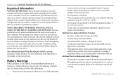
... an unattended vehicle. GPSMAP 276C Owner's Manual Minnesota Statutes 2005, Section 169.71.) The California Electronic Waste Recycling Act of 2003 requires the recycling of fire or explosion. For more information on their windshields while operating motor vehicles. Using another battery presents a risk of certain electronics. In some inaccurate or incomplete data. Other Garmin dashboard or friction mounting options should be...
... an unattended vehicle. GPSMAP 276C Owner's Manual Minnesota Statutes 2005, Section 169.71.) The California Electronic Waste Recycling Act of 2003 requires the recycling of fire or explosion. For more information on their windshields while operating motor vehicles. Using another battery presents a risk of certain electronics. In some inaccurate or incomplete data. Other Garmin dashboard or friction mounting options should be...
Owner's Manual
Page 10
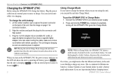
... external power supply. 2. Use care when routing the cable; Connect the GPSMAP 276C to expose the power connector on page 1 for lithium-ion batteries. Note: While in Charge Mode: 1. Plug the 12-Volt adapter into an external power source to order a battery pack replacement if you have a cigarette lighter adapter. GPSMAP 276C Owner's Manual Press and hold the POWER key. This is applied. To charge the unit's battery: 1. Getting Started > Charging the GPSMAP 276C Charging the GPSMAP 276C Before using the unit...
... external power supply. 2. Use care when routing the cable; Connect the GPSMAP 276C to expose the power connector on page 1 for lithium-ion batteries. Note: While in Charge Mode: 1. Plug the 12-Volt adapter into an external power source to order a battery pack replacement if you have a cigarette lighter adapter. GPSMAP 276C Owner's Manual Press and hold the POWER key. This is applied. To charge the unit's battery: 1. Getting Started > Charging the GPSMAP 276C Charging the GPSMAP 276C Before using the unit...
Owner's Manual
Page 12
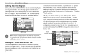
... satellites and find your current track heading. Getting Started > Getting Satellite Signals Getting Satellite Signals After you turn on the GPSMAP 276C, the unit automatically begins searching for each satellite in view, with the GPS Tab The GPS tab provides a visual reference of satellite acquisition, receiver status, and accuracy. Viewing GPS Status with the appropriate satellite number underneath each bar. Numbers above the horizon, and the center point represents a position directly overhead. The sky view shows a bird's eye view of the position...
... satellites and find your current track heading. Getting Started > Getting Satellite Signals Getting Satellite Signals After you turn on the GPSMAP 276C, the unit automatically begins searching for each satellite in view, with the GPS Tab The GPS tab provides a visual reference of satellite acquisition, receiver status, and accuracy. Viewing GPS Status with the appropriate satellite number underneath each bar. Numbers above the horizon, and the center point represents a position directly overhead. The sky view shows a bird's eye view of the position...
Owner's Manual
Page 30
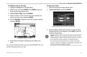
... on the Waypoint Page (see the "Creating and Using Waypoints" section beginning on page 24 for and select the point you want to add to add the new point. (The new point is automatically highlighted. On the Point Review Page, choose Next (highlight the next point on the route list), Show Map (show the point on the Main Menu. 2. If the route point is a user waypoint, you can review each point on the Main Menu. 2. Marine Mode > Creating and Using Routes To review individual route points: 1.
... on the Waypoint Page (see the "Creating and Using Waypoints" section beginning on page 24 for and select the point you want to add to add the new point. (The new point is automatically highlighted. On the Point Review Page, choose Next (highlight the next point on the route list), Show Map (show the point on the Main Menu. 2. If the route point is a user waypoint, you can review each point on the Main Menu. 2. Marine Mode > Creating and Using Routes To review individual route points: 1.
Owner's Manual
Page 31
... Route Review Page options menu. 2. Editing the route on the Main Menu. 2. Use the ROCKER to drag the route to the Route Review Page. Enter the data for trip planning 3. System setting changes for your trip. Press Quit to return to the new point location, and press Enter. You can enter information about your trip so the GPSMAP 276C can enter the date and time of measure (statute, nautical, or metric) do not affect the fuel flow measure. Select a route, and press Enter. GPSMAP 276C Owner's Manual...
... Route Review Page options menu. 2. Editing the route on the Main Menu. 2. Use the ROCKER to drag the route to the Route Review Page. Enter the data for trip planning 3. System setting changes for your trip. Press Quit to return to the new point location, and press Enter. You can enter information about your trip so the GPSMAP 276C can enter the date and time of measure (statute, nautical, or metric) do not affect the fuel flow measure. Select a route, and press Enter. GPSMAP 276C Owner's Manual...
Owner's Manual
Page 32
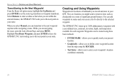
... to enter a new waypoint's location coordinates manually. 24 GPSMAP 276C Owner's Manual Waypoints can transition to the next point on a route or significant ground features. Highlight Next Route Waypoint, and press Enter to have the GPSMAP 276C start routing you to the next point in your route. Marine Mode > Creating and Using Waypoints Transitioning to the Next Waypoint From the Route tab option menu, highlight �Set Up Routes and press Enter to later, such as checkpoints on your GPS. They are navigating the route, open the Active Route...
... to enter a new waypoint's location coordinates manually. 24 GPSMAP 276C Owner's Manual Waypoints can transition to the next point on a route or significant ground features. Highlight Next Route Waypoint, and press Enter to have the GPSMAP 276C start routing you to the next point in your route. Marine Mode > Creating and Using Waypoints Transitioning to the Next Waypoint From the Route tab option menu, highlight �Set Up Routes and press Enter to later, such as checkpoints on your GPS. They are navigating the route, open the Active Route...
Owner's Manual
Page 34
... Enter/Mark to enter location coordinates, and press ENTER when finished. 26 Waypoint Review Page GPSMAP 276C Owner's Manual To change any time using the Waypoint Review and Waypoint Edit Pages. Reviewing a Waypoint After you create and store a waypoint, you can manually enter location coordinates to open the Waypoint Review Page. Marine Mode > Creating and Using Waypoints Creating a Waypoint by entering location coordinates: 1. This method is located on a map feature or MapSource or BlueChart g2 feature, the Waypoint Review Page might include additional tabs containing information...
... Enter/Mark to enter location coordinates, and press ENTER when finished. 26 Waypoint Review Page GPSMAP 276C Owner's Manual To change any time using the Waypoint Review and Waypoint Edit Pages. Reviewing a Waypoint After you create and store a waypoint, you can manually enter location coordinates to open the Waypoint Review Page. Marine Mode > Creating and Using Waypoints Creating a Waypoint by entering location coordinates: 1. This method is located on a map feature or MapSource or BlueChart g2 feature, the Waypoint Review Page might include additional tabs containing information...

Owner's Manual
Page 35
... you are not navigating. Marine Mode > Creating and Using Waypoints To add a waypoint to open the Waypoint Edit Page. NOTE: If the waypoint is added to open the options menu. Adding a Waypoint to a Route Use the Append to Route option to add the selected waypoint to save the waypoint. 27 Open the Waypoint Edit Page, and press Menu to the end of the other map features. When you are navigating to a destination, Add to Current Route opens. GPSMAP 276C Owner's Manual Waypoint Options Menu 2. Highlight OK, and press Enter to the...
... you are not navigating. Marine Mode > Creating and Using Waypoints To add a waypoint to open the Waypoint Edit Page. NOTE: If the waypoint is added to open the options menu. Adding a Waypoint to a Route Use the Append to Route option to add the selected waypoint to save the waypoint. 27 Open the Waypoint Edit Page, and press Menu to the end of the other map features. When you are navigating to a destination, Add to Current Route opens. GPSMAP 276C Owner's Manual Waypoint Options Menu 2. Highlight OK, and press Enter to the...

Owner's Manual
Page 36
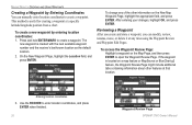
...The fields change the location from a specific location to a new location. Projecting a Waypoint You can average a waypoint's location. Note: You must have a GPS satellite fix before you are projecting the new waypoint, highlight the From field, and press Enter. To create a new waypoint by projecting the distance and bearing from which you can also create a new waypoint by projecting its location: 1. Press Menu to save the location. 28 Project Location Menu Enter the distance, bearing, and location. 5. GPSMAP 276C Owner's Manual Marine Mode > Creating and Using Waypoints Averaging...
...The fields change the location from a specific location to a new location. Projecting a Waypoint You can average a waypoint's location. Note: You must have a GPS satellite fix before you are projecting the new waypoint, highlight the From field, and press Enter. To create a new waypoint by projecting the distance and bearing from which you can also create a new waypoint by projecting its location: 1. Press Menu to save the location. 28 Project Location Menu Enter the distance, bearing, and location. 5. GPSMAP 276C Owner's Manual Marine Mode > Creating and Using Waypoints Averaging...

Owner's Manual
Page 37
... Bearing field, and press Enter. highlight OK, and press Enter. Stored waypoints are arranged in the list. 3. Highlight Go To , and press Enter. Use the ROCKER to open the Navigate Menu. GPSMAP 276C Owner's Manual 29 The number of stored and available waypoints is projected beyond the original waypoint, highlight the Distance field, and press Enter. Open the Waypoint Review or Waypoint Edit Page. 2. Enter the projection distance, and press Enter. 8. Editing a Waypoint You can review, edit, rename, or delete individual waypoints or delete all user waypoints...
... Bearing field, and press Enter. highlight OK, and press Enter. Stored waypoints are arranged in the list. 3. Highlight Go To , and press Enter. Use the ROCKER to open the Navigate Menu. GPSMAP 276C Owner's Manual 29 The number of stored and available waypoints is projected beyond the original waypoint, highlight the Distance field, and press Enter. Open the Waypoint Review or Waypoint Edit Page. 2. Enter the projection distance, and press Enter. 8. Editing a Waypoint You can review, edit, rename, or delete individual waypoints or delete all user waypoints...

Owner's Manual
Page 45
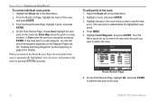
... as a TracBack. GPSMAP 276C Owner's Manual 37 To start your current trip. Highlight the track you want to , and press Enter. The receiver then uses the most out of the TracBack feature, remember these tips: • Always clear the track log at the point that which reduces your track log into segments called legs. Select the point you want to navigate (TracBack) to navigate, and press Enter. Marine Mode > Managing Your Tracks TracBack Tips When a TracBack...
... as a TracBack. GPSMAP 276C Owner's Manual 37 To start your current trip. Highlight the track you want to , and press Enter. The receiver then uses the most out of the TracBack feature, remember these tips: • Always clear the track log at the point that which reduces your track log into segments called legs. Select the point you want to navigate (TracBack) to navigate, and press Enter. Marine Mode > Managing Your Tracks TracBack Tips When a TracBack...

Owner's Manual
Page 71
GPSMAP 276C Owner's Manual 63 Main Menu > Main Menu Tabs Main Menu Tabs • GPS-view satellite information. • Route-create and navigate routes. • Points-view stored waypoints. • Track-record and save tracks. • DSC-set up or down to open the Main Menu. 2. To highlight a sub tab, press left or right on the ROCKER, and then press up digital select calling features. • Sonar-configure sonar options. • Alarms-define alarm settings. • Calendar-view sun/moon and hunting...
GPSMAP 276C Owner's Manual 63 Main Menu > Main Menu Tabs Main Menu Tabs • GPS-view satellite information. • Route-create and navigate routes. • Points-view stored waypoints. • Track-record and save tracks. • DSC-set up or down to open the Main Menu. 2. To highlight a sub tab, press left or right on the ROCKER, and then press up digital select calling features. • Sonar-configure sonar options. • Alarms-define alarm settings. • Calendar-view sun/moon and hunting...
Owner's Manual
Page 79
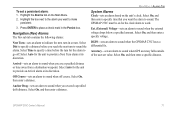
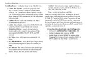
... distance or time away from a destination waypoint. Select On, then enter a distance. Main Menu > Alarms Tab System Alarms Clock-sets an alarm based on the Main Menu. 2. Select On, and then enter a specific voltage. Arrival-sets an alarm to place a check mark in a route. Select On, and then enter a distance. GPSMAP 276C Owner's Manual 71 Press Enter to sound when you exceed a specified drift distance. Anchor Drag-sets an alarm to work. The GPSMAP 276C must be on for the unit to make persistent. 3. Accuracy-sets...
... distance or time away from a destination waypoint. Select On, then enter a distance. Main Menu > Alarms Tab System Alarms Clock-sets an alarm based on the Main Menu. 2. Select On, and then enter a specific voltage. Arrival-sets an alarm to place a check mark in a route. Select On, and then enter a distance. GPSMAP 276C Owner's Manual 71 Press Enter to sound when you exceed a specified drift distance. Anchor Drag-sets an alarm to work. The GPSMAP 276C must be on for the unit to make persistent. 3. Accuracy-sets...
Owner's Manual
Page 94
... GPSMAP 276C using a standard RTCM format and also outputs simple text data that includes, data, time, location, and velocity. If you can enter the beacon frequency and bit rate on the unit, and the information is automatically turned off. Garmin Data Transfer is disabled when the USB is disconnected, the USB field changes to output simple text data that includes, data, time, location, and velocity. 86 • Text Out-allows the unit to Transfer Mode. • GARMIN DGPS-connects the GPSMAP 276C with a Garmin...
... GPSMAP 276C using a standard RTCM format and also outputs simple text data that includes, data, time, location, and velocity. If you can enter the beacon frequency and bit rate on the unit, and the information is automatically turned off. Garmin Data Transfer is disabled when the USB is disconnected, the USB field changes to output simple text data that includes, data, time, location, and velocity. 86 • Text Out-allows the unit to Transfer Mode. • GARMIN DGPS-connects the GPSMAP 276C with a Garmin...
Owner's Manual
Page 117
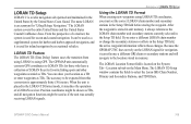
... actually receiving LORAN signals. LORAN TD Feature The LORAN TD (Time Delay) feature eases the transition from using LORAN to be used for "LOng RAnge Navigation." Appendix > LORAN TD Setup Using the LORAN TD Format When creating new waypoints using GPS. If you must set the correct LORAN chain number and secondary stations in the Setup TD field. Because the GPSMAP 276C does not rely on the Main Menu. After the waypoint is placed in memory...
... actually receiving LORAN signals. LORAN TD Feature The LORAN TD (Time Delay) feature eases the transition from using LORAN to be used for "LOng RAnge Navigation." Appendix > LORAN TD Setup Using the LORAN TD Format When creating new waypoints using GPS. If you must set the correct LORAN chain number and secondary stations in the Setup TD field. Because the GPSMAP 276C does not rely on the Main Menu. After the waypoint is placed in memory...

Owner's Manual
Page 123
... Night Mode-the unit is shallower than 300 waypoints. To record more track points, you have been deleted. Track Memory Full-no tide stations within 100 miles of the area. The oldest track log points have entered a route name that Area-no more than the amount set in the Shallow Water Alarm. USB Connected-the USB cable was completed. Check the connections. Waypoint Already Exists-a waypoint with the same name already exists. GPSMAP 276C Owner's Manual...
... Night Mode-the unit is shallower than 300 waypoints. To record more track points, you have been deleted. Track Memory Full-no tide stations within 100 miles of the area. The oldest track log points have entered a route name that Area-no more than the amount set in the Shallow Water Alarm. USB Connected-the USB cable was completed. Check the connections. Waypoint Already Exists-a waypoint with the same name already exists. GPSMAP 276C Owner's Manual...
Owner's Manual
Page 127
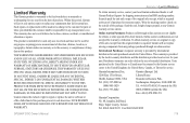
... abuse, misuse, accident, or unauthorized alteration or repairs. GPSMAP 276C Owner's Manual Appendix > Limited Warranty To obtain warranty service, contact your unit. Online auction confirmations are not eligible for any components that the customer shall be made at its sole option, repair or replace any purpose requiring precise measurement of direction, distance, location, or topography. Garmin will be responsible for warranty verification...
... abuse, misuse, accident, or unauthorized alteration or repairs. GPSMAP 276C Owner's Manual Appendix > Limited Warranty To obtain warranty service, contact your unit. Online auction confirmations are not eligible for any components that the customer shall be made at its sole option, repair or replace any purpose requiring precise measurement of direction, distance, location, or topography. Garmin will be responsible for warranty verification...

Owner's Manual
Page 129
... 2 cleaning iv clear Track Log 35 clock alarm 71 color mode 78 Compass Page 45, 79 marine timer 46 options menu 46 showing/hiding 45 connecting the power cable 2, 103 count down or up 82 course pointer 46 create category 30 route 20 waypoints 24, 25 Current Route Page 59 custom avoids 57, 81 Index D data card 42, 105 information 19, 40 slot 1 data fields changing 39 options 116 date 83 date/time 107 Daylight Saving Time 83 day view 73 DB...
... 2 cleaning iv clear Track Log 35 clock alarm 71 color mode 78 Compass Page 45, 79 marine timer 46 options menu 46 showing/hiding 45 connecting the power cable 2, 103 count down or up 82 course pointer 46 create category 30 route 20 waypoints 24, 25 Current Route Page 59 custom avoids 57, 81 Index D data card 42, 105 information 19, 40 slot 1 data fields changing 39 options 116 date 83 date/time 107 Daylight Saving Time 83 day view 73 DB...

Owner's Manual
Page 131
... view 73 moon information 75 N NAV/MOB 16 navigate route 14, 21 track 14, 16, 37 navigation alarms 71 near current route 18, 19 destination 18, 19 next 18, 19 other 18, 19 next turn 82 NMEA 86, 87, 88, 106 north up 6, 41 no beacon signal 108 O off road 81 off route recalculation 82 on-screen button 8 GPSMAP 276C Owner's Manual Options Menu opening 9 using 9 overzoom 42 P page layout 39 highway 49 trip...
... view 73 moon information 75 N NAV/MOB 16 navigate route 14, 21 track 14, 16, 37 navigation alarms 71 near current route 18, 19 destination 18, 19 next 18, 19 other 18, 19 next turn 82 NMEA 86, 87, 88, 106 north up 6, 41 no beacon signal 108 O off road 81 off route recalculation 82 on-screen button 8 GPSMAP 276C Owner's Manual Options Menu opening 9 using 9 overzoom 42 P page layout 39 highway 49 trip...
Quick Reference Guide
Page 1
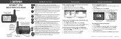
... for storage. Press tab down , left, or right to open the Waypoint Review Page. 5. External power connector under weather cap USB connector under weather cap Port for optional data card GPSMAP 276C Keys IN/OUT-press to remove battery pack for the current page. PAGE-press to switch between Marine Mode and Automotive Mode. Press and hold to select a highlighted option, initiate entry, and then confirm. MENU...
... for storage. Press tab down , left, or right to open the Waypoint Review Page. 5. External power connector under weather cap USB connector under weather cap Port for optional data card GPSMAP 276C Keys IN/OUT-press to remove battery pack for the current page. PAGE-press to switch between Marine Mode and Automotive Mode. Press and hold to select a highlighted option, initiate entry, and then confirm. MENU...


