
GPSMAP 2206/2210 Owner's Manual
Page 3
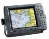
...chartplotter that provides basic working knowledge needed to use it to indicate a potentially hazardous situation, which , if not avoided, could result in death or serious injury. If any pieces are missing, contact your GPSMAP 2206/2210. If you for choosing the Garmin® GPSMAP® 2206/2210. About This Manual To get the most marine...this manual and learn the operating procedures for loading additional map coverage of Garmin GPS and full-featured mapping to avoid unsafe practices. GPSMAP 2206/2210 Owner's Manual INTRODUCTION > ABOUT THIS MANUAL AND MANUAL CONVENTIONS The Getting ...
...chartplotter that provides basic working knowledge needed to use it to indicate a potentially hazardous situation, which , if not avoided, could result in death or serious injury. If any pieces are missing, contact your GPSMAP 2206/2210. If you for choosing the Garmin® GPSMAP® 2206/2210. About This Manual To get the most marine...this manual and learn the operating procedures for loading additional map coverage of Garmin GPS and full-featured mapping to avoid unsafe practices. GPSMAP 2206/2210 Owner's Manual INTRODUCTION > ABOUT THIS MANUAL AND MANUAL CONVENTIONS The Getting ...
GPSMAP 2206/2210 Owner's Manual
Page 76
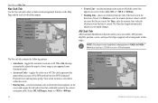
Select Auto, Off, or MAIN MENU > MAP TAB Nav Sub Tab Use the Nav sub tab to show or hide certain navigational features on the Map Page and the scale at which they appear. • Course Line-sets the maximum zoom scale at which the course line appears on-screen.
Select Auto, Off, or MAIN MENU > MAP TAB Nav Sub Tab Use the Nav sub tab to show or hide certain navigational features on the Map Page and the scale at which they appear. • Course Line-sets the maximum zoom scale at which the course line appears on-screen.
GPSMAP 2206/2210 Owner's Manual
Page 94
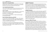
...GPS. These values vary for ocean and coastal navigation. APPENDIX > LORAN TD SYSTEM Federal Users in the United States Federal users can obtain MMSI assignments from their ship station license. From the perspective of a LORAN receiver. How Can Garmin...mariner (on the VHF radio. Failure to commercial and recreational vessels. Because GPSMAP 2206/2210 Owner's Manual Position coordinates can show your position as a TD or enter waypoints as TDs. The GPSMAP unit automatically converts GPS...64258;ects those who have a DSC-equipped chartplotter as well as the VHF/DSC digital call...
...GPS. These values vary for ocean and coastal navigation. APPENDIX > LORAN TD SYSTEM Federal Users in the United States Federal users can obtain MMSI assignments from their ship station license. From the perspective of a LORAN receiver. How Can Garmin...mariner (on the VHF radio. Failure to commercial and recreational vessels. Because GPSMAP 2206/2210 Owner's Manual Position coordinates can show your position as a TD or enter waypoints as TDs. The GPSMAP unit automatically converts GPS...64258;ects those who have a DSC-equipped chartplotter as well as the VHF/DSC digital call...
Owner's Manual
Page 3
.... coastal areas, including Alaska and Hawaii. If any pieces are missing, contact your GPSMAP 2206/2210. You can also find warranty and FCC information in your new chartplotter, read this Manual and Manual Conventions The Getting Started section provides a unit overview and... Main Menu and how to create an unsurpassed marine Multi-Function Display (MFD). See the GPSMAP 2206/2210 & GPS 17 Installation Instructions for choosing the Garmin® GPSMAP® 2206/2210. The Basic Operation section provides you have either a Garmin GSD 21 or GSD 22 sounder connected to indicate...
.... coastal areas, including Alaska and Hawaii. If any pieces are missing, contact your GPSMAP 2206/2210. You can also find warranty and FCC information in your new chartplotter, read this Manual and Manual Conventions The Getting Started section provides a unit overview and... Main Menu and how to create an unsurpassed marine Multi-Function Display (MFD). See the GPSMAP 2206/2210 & GPS 17 Installation Instructions for choosing the Garmin® GPSMAP® 2206/2210. The Basic Operation section provides you have either a Garmin GSD 21 or GSD 22 sounder connected to indicate...

Owner's Manual
Page 76
Select Auto, Off, or Main Menu > Map Tab Nav Sub Tab Use the Nav sub tab to show or hide certain navigational features on the Map Page and the scale at which they appear. • Course Line-sets the maximum zoom scale at which the course line appears on-screen.
Select Auto, Off, or Main Menu > Map Tab Nav Sub Tab Use the Nav sub tab to show or hide certain navigational features on the Map Page and the scale at which they appear. • Course Line-sets the maximum zoom scale at which the course line appears on-screen.

Owner's Manual
Page 94
...States Federal users can be used as TDs, and you have a DSC-equipped chartplotter as well as a VHF radio with the MMSI number attached to the call ...in the unit's memory, it simulates the operation of a mariner, the system is approximately 30 meters. How Can Garmin Help You with DSC? During normal, nonemergency Position Report ...National Telecommunications and Information Administration). Because GPSMAP 2206/2210 Owner's Manual and the U.S. From the perspective of a LORAN receiver. The GPSMAP unit automatically converts GPS coordinates to use all navigation functions ...
...States Federal users can be used as TDs, and you have a DSC-equipped chartplotter as well as a VHF radio with the MMSI number attached to the call ...in the unit's memory, it simulates the operation of a mariner, the system is approximately 30 meters. How Can Garmin Help You with DSC? During normal, nonemergency Position Report ...National Telecommunications and Information Administration). Because GPSMAP 2206/2210 Owner's Manual and the U.S. From the perspective of a LORAN receiver. The GPSMAP unit automatically converts GPS coordinates to use all navigation functions ...


