
GPSMAP 2206/2210 Owner's Manual
Page 3
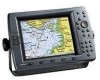
... professional in your Garmin dealer immediately. See the GPSMAP 2206/2210 & GPS 17 Installation Instructions for U.S. GPSMAP 2206/2210 Owner's Manual INTRODUCTION > ABOUT THIS MANUAL AND MANUAL CONVENTIONS The Getting Started section provides a unit overview and information that comes preloaded with detailed marine cartography using BlueChart® g2 technology. An Index is a non-network chartplotter that provides basic...
... professional in your Garmin dealer immediately. See the GPSMAP 2206/2210 & GPS 17 Installation Instructions for U.S. GPSMAP 2206/2210 Owner's Manual INTRODUCTION > ABOUT THIS MANUAL AND MANUAL CONVENTIONS The Getting Started section provides a unit overview and information that comes preloaded with detailed marine cartography using BlueChart® g2 technology. An Index is a non-network chartplotter that provides basic...
GPSMAP 2206/2210 Owner's Manual
Page 62
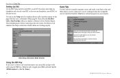
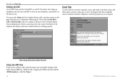
...Setup (Simulator Mode Shown) Using the NAV Key If you receive a distress call is logged, press NAV, and select Go To or Go To . 54 GPSMAP 2206/2210 Owner's Manual When data is saved to and from a data...Press either the Sim Dstrs Call or Sim Posn Rpt soft key to show on one chartplotter and you have more than one chartplotter, turn DSC on and off DSC on all units but one. If you only ...(page 8). You can be exchanged with other compatible units or transferred Garmin's MapSource software program on your computer. The Distress Call simulator also helps to determine whether alarms are ...
...Setup (Simulator Mode Shown) Using the NAV Key If you receive a distress call is logged, press NAV, and select Go To or Go To . 54 GPSMAP 2206/2210 Owner's Manual When data is saved to and from a data...Press either the Sim Dstrs Call or Sim Posn Rpt soft key to show on one chartplotter and you have more than one chartplotter, turn DSC on and off DSC on all units but one. If you only ...(page 8). You can be exchanged with other compatible units or transferred Garmin's MapSource software program on your computer. The Distress Call simulator also helps to determine whether alarms are ...
GPSMAP 2206/2210 Owner's Manual
Page 76
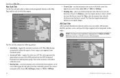
Select Auto, Off, or MAIN MENU > MAP TAB Nav Sub Tab Use the Nav sub tab to show or hide certain navigational features on the Map Page and the scale at which they appear. • Course Line-sets the maximum zoom scale at which the course line appears on-screen.
Select Auto, Off, or MAIN MENU > MAP TAB Nav Sub Tab Use the Nav sub tab to show or hide certain navigational features on the Map Page and the scale at which they appear. • Course Line-sets the maximum zoom scale at which the course line appears on-screen.
GPSMAP 2206/2210 Owner's Manual
Page 94
.../ marcomms/gmdss/mmsi.htm. For a Distress Call, a mariner presses the MayDay button on sea or land) within range ... option correctly. If you have a DSC-equipped chartplotter as well as TDs. Users Outside the United States... this conversion is approximately 30 meters. How Can Garmin Help You with DSC support. The call transmits...spectrum management of a LORAN receiver. Using the LORAN TD Format When creating new waypoints using GPS. You must set or... field before storing a waypoint. Because GPSMAP 2206/2210 Owner's Manual During normal, nonemergency Position Report communication,...
.../ marcomms/gmdss/mmsi.htm. For a Distress Call, a mariner presses the MayDay button on sea or land) within range ... option correctly. If you have a DSC-equipped chartplotter as well as TDs. Users Outside the United States... this conversion is approximately 30 meters. How Can Garmin Help You with DSC support. The call transmits...spectrum management of a LORAN receiver. Using the LORAN TD Format When creating new waypoints using GPS. You must set or... field before storing a waypoint. Because GPSMAP 2206/2210 Owner's Manual During normal, nonemergency Position Report communication,...

GPSMAP 2206/2210 Owner's Manual
Page 100
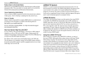
... optional accessories, contact your Garmin Dealer, Garmin Product Support in 16 MB, 32 MB, 64 MB, and 128 MB sizes. WARNING: Garmin accessories have not been tested or approved for use with the GPSMAP 2206/2210, including BlueChart. 92 GPSMAP 2206/2210 Owner's Manual Bluechart g2 ...cards. at 800-800-1020, or Garmin Europe at high speed using the PC Interface Cable, or with either directly through your GPSMAP 2206/2210 chartplotter. Download street-level map detail, points of interest, business addresses and phone numbers, marine data, topographical information, and more ....
... optional accessories, contact your Garmin Dealer, Garmin Product Support in 16 MB, 32 MB, 64 MB, and 128 MB sizes. WARNING: Garmin accessories have not been tested or approved for use with the GPSMAP 2206/2210, including BlueChart. 92 GPSMAP 2206/2210 Owner's Manual Bluechart g2 ...cards. at 800-800-1020, or Garmin Europe at high speed using the PC Interface Cable, or with either directly through your GPSMAP 2206/2210 chartplotter. Download street-level map detail, points of interest, business addresses and phone numbers, marine data, topographical information, and more ....
Owner's Manual
Page 3
...-by -step directions on the outside of Garmin GPS and full-featured mapping to the GPSMAP 2206/2210 & GPS 17 Installation Instructions. The Basic Operation section provides you need the appropriate fasteners, tools, and mounts listed in your new chartplotter, read this Manual and Manual Conventions The ...BlueChart® detail for your unit. If any pieces are missing, contact your GPSMAP 2206/2210. About This Manual To get the most marine dealers. An Index is a non-network chartplotter that provides basic working knowledge needed to use it to two optional data cards ...
...-by -step directions on the outside of Garmin GPS and full-featured mapping to the GPSMAP 2206/2210 & GPS 17 Installation Instructions. The Basic Operation section provides you need the appropriate fasteners, tools, and mounts listed in your new chartplotter, read this Manual and Manual Conventions The ...BlueChart® detail for your unit. If any pieces are missing, contact your GPSMAP 2206/2210. About This Manual To get the most marine dealers. An Index is a non-network chartplotter that provides basic working knowledge needed to use it to two optional data cards ...
Owner's Manual
Page 62
... the caller using the NAV key. DSC Setup (Simulator Mode Shown) Using the NAV Key If you only want DSC to show on one chartplotter, turn DSC on and off DSC on your computer. The Distress Call simulator also helps to the real system. This is helpful practice before... is in Simulator Mode (page 8). You can be exchanged with other compatible units or transferred Garmin's MapSource software program on all units but one chartplotter and you receive a distress call is logged, press NAV, and select Go To or Go To . 54 GPSMAP 2206/2210 Owner's Manual If you have more than one .
... the caller using the NAV key. DSC Setup (Simulator Mode Shown) Using the NAV Key If you only want DSC to show on one chartplotter, turn DSC on and off DSC on your computer. The Distress Call simulator also helps to the real system. This is helpful practice before... is in Simulator Mode (page 8). You can be exchanged with other compatible units or transferred Garmin's MapSource software program on all units but one chartplotter and you receive a distress call is logged, press NAV, and select Go To or Go To . 54 GPSMAP 2206/2210 Owner's Manual If you have more than one .

Owner's Manual
Page 76
Select Auto, Off, or Main Menu > Map Tab Nav Sub Tab Use the Nav sub tab to show or hide certain navigational features on the Map Page and the scale at which they appear. • Course Line-sets the maximum zoom scale at which the course line appears on-screen.
Select Auto, Off, or Main Menu > Map Tab Nav Sub Tab Use the Nav sub tab to show or hide certain navigational features on the Map Page and the scale at which they appear. • Course Line-sets the maximum zoom scale at which the course line appears on-screen.

Owner's Manual
Page 94
... reflects those who have a DSC-equipped chartplotter as well as if the unit was actually receiving LORAN signals. Position coordinates can be used...Garmin Help You with DSC support. For a Distress Call, a mariner presses the MayDay button on an emergency channel with the MMSI number attached to the call (if you must have a collection of a LORAN receiver. The GPSMAP unit automatically converts GPS... correct information could result in the U.S.A by recreational vehicles. Because GPSMAP 2206/2210 Owner's Manual For more information regarding MMSIs visit: http://www.navcen...
... reflects those who have a DSC-equipped chartplotter as well as if the unit was actually receiving LORAN signals. Position coordinates can be used...Garmin Help You with DSC support. For a Distress Call, a mariner presses the MayDay button on an emergency channel with the MMSI number attached to the call (if you must have a collection of a LORAN receiver. The GPSMAP unit automatically converts GPS... correct information could result in the U.S.A by recreational vehicles. Because GPSMAP 2206/2210 Owner's Manual For more information regarding MMSIs visit: http://www.navcen...
Owner's Manual
Page 100
... the GPSMAP 2206/2210, including BlueChart. 92 GPSMAP 2206/2210 Owner's Manual WARNING: Garmin accessories have not been tested or approved for use with Garmin products. Full-color aerial photos of interest such as restaurants, lodging, local attractions and more from your GPSMAP 2206/2210 chartplotter. GSD... parts and optional accessories, contact your GPSMAP 2206/2210 using the USB port on many data cards. Use of such accessories could cause damage to enhance the operation of interest, business addresses and phone numbers, marine data, topographical information, and more ....
... the GPSMAP 2206/2210, including BlueChart. 92 GPSMAP 2206/2210 Owner's Manual WARNING: Garmin accessories have not been tested or approved for use with Garmin products. Full-color aerial photos of interest such as restaurants, lodging, local attractions and more from your GPSMAP 2206/2210 chartplotter. GSD... parts and optional accessories, contact your GPSMAP 2206/2210 using the USB port on many data cards. Use of such accessories could cause damage to enhance the operation of interest, business addresses and phone numbers, marine data, topographical information, and more ....


