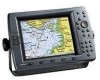
GPSMAP 2206/2210 Installation Instructions
Page 2
... a single copy of this document is being provided in the United States or Canada must contain the complete text of purchase. Garmin®, GPS®, CANet®, and Ultrascroll™ are not eligible for warranty repairs. Safety Information WARNING: This product, its packaging, ..., disseminated, downloaded, or stored in Taiwan This warranty is required. Garmin reserves the right to notify any revision hereto is required as expressly provided herein, no charge to the customer for current updates and supplemental information concerning the use . Some states do not allow...
... a single copy of this document is being provided in the United States or Canada must contain the complete text of purchase. Garmin®, GPS®, CANet®, and Ultrascroll™ are not eligible for warranty repairs. Safety Information WARNING: This product, its packaging, ..., disseminated, downloaded, or stored in Taiwan This warranty is required. Garmin reserves the right to notify any revision hereto is required as expressly provided herein, no charge to the customer for current updates and supplemental information concerning the use . Some states do not allow...
GPSMAP 2206/2210 Owner's Manual
Page 2
... provided further that any unauthorized commercial distribution of this manual or any storage medium, for current updates and supplemental information concerning the use and operation of Garmin. or its products and to notify any purpose without the express prior written consent of this ...expressly provided herein, no part of such changes or improvements. Tel. 913/397.8200 or 800/800.1020 Fax 913/397.8282 Garmin (Europe) Ltd. Garmin®, GPSMAP®, AutoLocate®, TracBack®, BlueChart®, BlueChart® g2™ and MapSource®, See-Thru®, DynaColor™,...
... provided further that any unauthorized commercial distribution of this manual or any storage medium, for current updates and supplemental information concerning the use and operation of Garmin. or its products and to notify any purpose without the express prior written consent of this ...expressly provided herein, no part of such changes or improvements. Tel. 913/397.8200 or 800/800.1020 Fax 913/397.8282 Garmin (Europe) Ltd. Garmin®, GPSMAP®, AutoLocate®, TracBack®, BlueChart®, BlueChart® g2™ and MapSource®, See-Thru®, DynaColor™,...
GPSMAP 2206/2210 Owner's Manual
Page 5
... Highway Page 41 Changing the Highway Perspective Range 41 Highway Page Options 41 Showing or Hiding Cartography 42 Main Menu 43 GPS Tab...43 Tide Tab ...44 Tide Sub Tab ...44 Current Sub Tab ...46 Celestial Tab 47 Trip Tab...48 Points...Tab ...56 System Alarms ...57 Nav (Navigation) Alarms 57 Sonar Alarms* ...58 INTRODUCTION > TABLE OF CONTENTS System Tab 58 Update Sub Tab...63 Network Tab 64 Pages Tab...64 Map Tab ...65 AIS Sub Tab...68 Temp (Temperature) Tab 70 Sonar Tab... Tab ...78 General Sub Tab ...79 Graph Sub Tab ...80 Water Temp Sub Tab 81 GPSMAP 2206/2210 Owner's Manual iii
... Highway Page 41 Changing the Highway Perspective Range 41 Highway Page Options 41 Showing or Hiding Cartography 42 Main Menu 43 GPS Tab...43 Tide Tab ...44 Tide Sub Tab ...44 Current Sub Tab ...46 Celestial Tab 47 Trip Tab...48 Points...Tab ...56 System Alarms ...57 Nav (Navigation) Alarms 57 Sonar Alarms* ...58 INTRODUCTION > TABLE OF CONTENTS System Tab 58 Update Sub Tab...63 Network Tab 64 Pages Tab...64 Map Tab ...65 AIS Sub Tab...68 Temp (Temperature) Tab 70 Sonar Tab... Tab ...78 General Sub Tab ...79 Graph Sub Tab ...80 Water Temp Sub Tab 81 GPSMAP 2206/2210 Owner's Manual iii
GPSMAP 2206/2210 Owner's Manual
Page 25
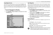
... a large number of available and used . • Del by page. 3. Press up or down . The Proximity sub tab also provides a continuously updated proximity waypoint alarm that use to scroll by Smbl-deletes waypoints that you to scroll through and review the waypoint list: 1. The number of waypoints...through the list of all waypoints from the Main Menu: 1. Press the Next soft key to return to open the Main Menu. 2. GPSMAP 2206/2210 Owner's Manual 17 Sub tabs BASIC OPERATION > REVIEWING AND EDITING WAYPOINTS User Waypoints The User sub tab on the ROCKER to define...
... a large number of available and used . • Del by page. 3. Press up or down . The Proximity sub tab also provides a continuously updated proximity waypoint alarm that use to scroll by Smbl-deletes waypoints that you to scroll through and review the waypoint list: 1. The number of waypoints...through the list of all waypoints from the Main Menu: 1. Press the Next soft key to return to open the Main Menu. 2. GPSMAP 2206/2210 Owner's Manual 17 Sub tabs BASIC OPERATION > REVIEWING AND EDITING WAYPOINTS User Waypoints The User sub tab on the ROCKER to define...

GPSMAP 2206/2210 Owner's Manual
Page 53
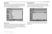
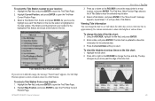
... the date to open the Find Tides Page. 2. Highlight the For field, and press ENTER to see tide charts for the selected date. 3. GPSMAP 2206/2210 Owner's Manual 45 As you move the map pointer to show tide heights at various times on the ROCKER to move past the edge of... the list. The day changes as you move the time bar in the list, the station is updated to show tide information for other days or...
... the date to open the Find Tides Page. 2. Highlight the For field, and press ENTER to see tide charts for the selected date. 3. GPSMAP 2206/2210 Owner's Manual 45 As you move the map pointer to show tide heights at various times on the ROCKER to move past the edge of... the list. The day changes as you move the time bar in the list, the station is updated to show tide information for other days or...
GPSMAP 2206/2210 Owner's Manual
Page 57
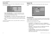
The sub tabs also provide continuously updated proximity waypoint alarms that can add proximity alarms to up to define items, such as submerged hazards or shallow waters. MAIN MENU > POINTS ... of all user waypoints. Number of waypoints remaining Number of used to 10 waypoints, with a maximum alarm radius of waypoints quickly and efficiently. GPSMAP 2206/2210 Owner's Manual 49 Points Tab The Points tab contains two sub tabs, User and Proximity, which allow you avoid reefs, rocks, or restricted waters...
The sub tabs also provide continuously updated proximity waypoint alarms that can add proximity alarms to up to define items, such as submerged hazards or shallow waters. MAIN MENU > POINTS ... of all user waypoints. Number of waypoints remaining Number of used to 10 waypoints, with a maximum alarm radius of waypoints quickly and efficiently. GPSMAP 2206/2210 Owner's Manual 49 Points Tab The Points tab contains two sub tabs, User and Proximity, which allow you avoid reefs, rocks, or restricted waters...
GPSMAP 2206/2210 Owner's Manual
Page 66
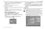
... • Speed Filter-averages speed readings. You can specify offset minutes for practice only). GPSMAP 2206/2210 Owner's Manual Select Off, Auto (automatically controls filtering), or On (allows you ...select Normal (normal navigation) or Simulator (for before sunrise and after sunset. You must be receiving sonar data for this function to work. • Water Temperature-sets an alarm to sound ... unit detects a fish of five sub tabs:General, Units, Time, Comm, and Update. • Shallow Water/Deep Water-sets an alarm to sound when you to enter a value from...
... • Speed Filter-averages speed readings. You can specify offset minutes for practice only). GPSMAP 2206/2210 Owner's Manual Select Off, Auto (automatically controls filtering), or On (allows you ...select Normal (normal navigation) or Simulator (for before sunrise and after sunset. You must be receiving sonar data for this function to work. • Water Temperature-sets an alarm to sound ... unit detects a fish of five sub tabs:General, Units, Time, Comm, and Update. • Shallow Water/Deep Water-sets an alarm to sound when you to enter a value from...
GPSMAP 2206/2210 Owner's Manual
Page 67
...System Info-shows the unit's software, basemap version, and electronic serial number. • Update Notes-shows software notes for the current software version. • Factory Dflts-restores all settings to Garmin's original setup values for all devices on the Units sub tab match that of measure... are using a map or chart with your GPS, make sure the settings on the network. Using the ROCKER, highlight On, and press ENTER. 3. Enter the offset minutes for the unit's on the GPSMAP 2206/2210...
...System Info-shows the unit's software, basemap version, and electronic serial number. • Update Notes-shows software notes for the current software version. • Factory Dflts-restores all settings to Garmin's original setup values for all devices on the Units sub tab match that of measure... are using a map or chart with your GPS, make sure the settings on the network. Using the ROCKER, highlight On, and press ENTER. 3. Enter the offset minutes for the unit's on the GPSMAP 2206/2210...
GPSMAP 2206/2210 Owner's Manual
Page 68
...Garmin weather product for distance, speed and elevation readouts in Nautical (nm, kt, ft), Nautical (nm, kt, m), Statute (mi, mh, ft), or Metric (km, kh, m) terms. • Pressure-set the reference used in ), Millibars (mb), or Hectopascals (hPa). Failure to update this setting, the GPSMAP 2206/2210...setting is latitude and longitude in substantial differences between the information displayed on your present location. User Mag Var allows you must be receiving NMEA Sonar depth data or using this setting can result in degrees, minutes, and thousandths of a minute (hddd°mm....
...Garmin weather product for distance, speed and elevation readouts in Nautical (nm, kt, ft), Nautical (nm, kt, m), Statute (mi, mh, ft), or Metric (km, kh, m) terms. • Pressure-set the reference used in ), Millibars (mb), or Hectopascals (hPa). Failure to update this setting, the GPSMAP 2206/2210...setting is latitude and longitude in substantial differences between the information displayed on your present location. User Mag Var allows you must be receiving NMEA Sonar depth data or using this setting can result in degrees, minutes, and thousandths of a minute (hddd°mm....

GPSMAP 2206/2210 Owner's Manual
Page 71
... Setup soft key to turn the GPS status (GSA, GSV), Waypoint/Route (WPL, RTE), and the Garmin proprietary sentences on your personal computer to download software updates for devices connected to your system. Using Marine Updater, you put all devices on your unit. • Prepare Card-updates software for your GPSMAP 2206/2210. Advanced NMEA Setup Page To...
... Setup soft key to turn the GPS status (GSA, GSV), Waypoint/Route (WPL, RTE), and the Garmin proprietary sentences on your personal computer to download software updates for devices connected to your system. Using Marine Updater, you put all devices on your unit. • Prepare Card-updates software for your GPSMAP 2206/2210. Advanced NMEA Setup Page To...

GPSMAP 2206/2210 Owner's Manual
Page 86
... Page You can mark waypoints that are under the surface of the water. Use the Sonar tab to the Sonar Page. 78 GPSMAP 2206/2210 Owner's Manual The Review Waypoint Page appears with the waypoint's coordinates, default name, and pointer depth automatically filled in. ...3. When using this feature, the Sonar Page pauses. This makes it starts again. Marking an Underwater Waypoint You can display the pointer (arrow) to update...
... Page You can mark waypoints that are under the surface of the water. Use the Sonar tab to the Sonar Page. 78 GPSMAP 2206/2210 Owner's Manual The Review Waypoint Page appears with the waypoint's coordinates, default name, and pointer depth automatically filled in. ...3. When using this feature, the Sonar Page pauses. This makes it starts again. Marking an Underwater Waypoint You can display the pointer (arrow) to update...
GPSMAP 2206/2210 Owner's Manual
Page 90
...: GPSMAP 2206: 3.0 lbs (1.4 kg) GPSMAP 2210: 5.0 lbs (2.3 kg) Display: GPSMAP 2206: 6.4" diagonal (16.3 cm) GPSMAP 2210: 10.4" diagonal (26.4 cm) High resolution, 256-color TFT (640 x 480 pixels), full VGA, with GPS 17) Receiver: Differential-ready 12 parallel channel WAAS-capable receiver Acquisition Times: Warm: Approx. 15 seconds Cold: Approx. 45 seconds AutoLocate: Approx. 2 minutes Update Rate: 1/second, continuous GPS Accuracy...
...: GPSMAP 2206: 3.0 lbs (1.4 kg) GPSMAP 2210: 5.0 lbs (2.3 kg) Display: GPSMAP 2206: 6.4" diagonal (16.3 cm) GPSMAP 2210: 10.4" diagonal (26.4 cm) High resolution, 256-color TFT (640 x 480 pixels), full VGA, with GPS 17) Receiver: Differential-ready 12 parallel channel WAAS-capable receiver Acquisition Times: Warm: Approx. 15 seconds Cold: Approx. 45 seconds AutoLocate: Approx. 2 minutes Update Rate: 1/second, continuous GPS Accuracy...
GPSMAP 2206/2210 Owner's Manual
Page 99
... device. Waypoint Memory Is Full, Can't Create Waypoint-you were connected to needs a software update. Modify the route name or delete the previous route name. Route Memory Is Full, Can... be added until existing ones are connected to has either been disconnected, or the GPSMAP 2206/2210 has lost communication with the unit. Modify the waypoint name or delete the existing ...exists in Simulator Mode. Sonar Failed, Unit Needs Repair-there is full. Contact your dealer or Garmin Product Support to a route. APPENDIX > MESSAGES AND ALARMS Sonar Service Lost-the external sonar device...
... device. Waypoint Memory Is Full, Can't Create Waypoint-you were connected to needs a software update. Modify the route name or delete the previous route name. Route Memory Is Full, Can... be added until existing ones are connected to has either been disconnected, or the GPSMAP 2206/2210 has lost communication with the unit. Modify the waypoint name or delete the existing ...exists in Simulator Mode. Sonar Failed, Unit Needs Repair-there is full. Contact your dealer or Garmin Product Support to a route. APPENDIX > MESSAGES AND ALARMS Sonar Service Lost-the external sonar device...

GPSMAP 2206/2210 Owner's Manual
Page 106
Garmin (Europe) Ltd. Unit 5, The Quadrangle, Abbey Park Industrial Estate, Romsey, SO51 9DL, U.K. or its subsidiaries Garmin International, Inc. 1200 East 151st Street, Olathe, Kansas 66062, U.S.A. Garmin Corporation No. 68, Jangshu 2nd Road, Shijr, Taipei County, Taiwan www.garmin.com 190-00678-00 Rev. B For the latest free software updates (excluding map data) throughout the life of your Garmin products, visit the Garmin Web site at www.garmin.com. © Copyright 2006 Garmin Ltd.
Garmin (Europe) Ltd. Unit 5, The Quadrangle, Abbey Park Industrial Estate, Romsey, SO51 9DL, U.K. or its subsidiaries Garmin International, Inc. 1200 East 151st Street, Olathe, Kansas 66062, U.S.A. Garmin Corporation No. 68, Jangshu 2nd Road, Shijr, Taipei County, Taiwan www.garmin.com 190-00678-00 Rev. B For the latest free software updates (excluding map data) throughout the life of your Garmin products, visit the Garmin Web site at www.garmin.com. © Copyright 2006 Garmin Ltd.
Owner's Manual
Page 2
... Tel. (913) 397.8200 or (800) 800.1020 Fax (913) 397.8282 Garmin (Europe) Ltd. Garmin reserves the right to make changes in any storage medium, for current updates and supplemental information concerning the use and operation of such changes or improvements. or its products... hereto is strictly prohibited. Except as expressly provided herein, no part of this document is a trademark of Garmin. November 2006 Part Number 190-00678-00 Rev. Garmin®, GPSMAP®, AutoLocate®, TracBack®, BlueChart®, BlueChart® g2™ and MapSource®, SeeThru®...
... Tel. (913) 397.8200 or (800) 800.1020 Fax (913) 397.8282 Garmin (Europe) Ltd. Garmin reserves the right to make changes in any storage medium, for current updates and supplemental information concerning the use and operation of such changes or improvements. or its products... hereto is strictly prohibited. Except as expressly provided herein, no part of this document is a trademark of Garmin. November 2006 Part Number 190-00678-00 Rev. Garmin®, GPSMAP®, AutoLocate®, TracBack®, BlueChart®, BlueChart® g2™ and MapSource®, SeeThru®...
Owner's Manual
Page 5
...Highway Page 41 Changing the Highway Perspective Range 41 Highway Page Options 41 Showing or Hiding Cartography 42 Main Menu 43 GPS Tab...43 Tide Tab...44 Tide Sub Tab...44 Current Sub Tab...46 Celestial Tab 47 Trip Tab...48 Points ... Alarms Tab...56 System Alarms...57 Nav (Navigation) Alarms 57 Sonar Alarms...58 Introduction > Table of Contents System Tab...58 Update Sub Tab...63 Network Tab 64 Pages Tab...64 Map Tab...65 AIS Sub Tab...68 Temp (Temperature) Tab 70 Sonar...78 Sonar Tab...78 General Sub Tab...79 Graph Sub Tab...80 Water Temp Sub Tab 81 GPSMAP 2206/2210 Owner's Manual iii
...Highway Page 41 Changing the Highway Perspective Range 41 Highway Page Options 41 Showing or Hiding Cartography 42 Main Menu 43 GPS Tab...43 Tide Tab...44 Tide Sub Tab...44 Current Sub Tab...46 Celestial Tab 47 Trip Tab...48 Points ... Alarms Tab...56 System Alarms...57 Nav (Navigation) Alarms 57 Sonar Alarms...58 Introduction > Table of Contents System Tab...58 Update Sub Tab...63 Network Tab 64 Pages Tab...64 Map Tab...65 AIS Sub Tab...68 Temp (Temperature) Tab 70 Sonar...78 Sonar Tab...78 General Sub Tab...79 Graph Sub Tab...80 Water Temp Sub Tab 81 GPSMAP 2206/2210 Owner's Manual iii
Owner's Manual
Page 25
...on the Review Waypoint Page. NOTE: When you delete a waypoint from the list, it cannot be recovered from the Main Menu: 1. GPSMAP 2206/2210 Owner's Manual 17 The next waypoint in alphanumeric order. Press and hold ADJ/MENU to the waypoint list. The number of available and used...• Delete-deletes the selected waypoint from the list and from any route in memory. The Proximity sub tab also provides a continuously updated proximity waypoint alarm that use to define an alarm circle around submerged hazards or shallow waters. See page 15 for information on the Main...
...on the Review Waypoint Page. NOTE: When you delete a waypoint from the list, it cannot be recovered from the Main Menu: 1. GPSMAP 2206/2210 Owner's Manual 17 The next waypoint in alphanumeric order. Press and hold ADJ/MENU to the waypoint list. The number of available and used...• Delete-deletes the selected waypoint from the list and from any route in memory. The Proximity sub tab also provides a continuously updated proximity waypoint alarm that use to define an alarm circle around submerged hazards or shallow waters. See page 15 for information on the Main...
Owner's Manual
Page 53
...move the highlight over each Tide Station in approximately five minute increments to show tide information for the selected date. 3. Highlight the tide chart. 2. GPSMAP 2206/2210 Owner's Manual 45 Select a Tide Station from a map location: 1. If the "None Found" message appears, repeat steps 1-3 until you are shown..., highlight the On field, and press ENTER. 2. The day changes as you move the time bar in the list, the station is updated to show tide heights at various times. Use the Map Position option to select a location closer to return. To view tide heights at ...
...move the highlight over each Tide Station in approximately five minute increments to show tide information for the selected date. 3. Highlight the tide chart. 2. GPSMAP 2206/2210 Owner's Manual 45 Select a Tide Station from a map location: 1. If the "None Found" message appears, repeat steps 1-3 until you are shown..., highlight the On field, and press ENTER. 2. The day changes as you move the time bar in the list, the station is updated to show tide heights at various times. Use the Map Position option to select a location closer to return. To view tide heights at ...

Owner's Manual
Page 57
... Menu > Points Tab Proximity Sub Tab Use the Proximity sub tab on the Points tab displays a master list of all user waypoints. GPSMAP 2206/2210 Owner's Manual 49 The total number of stored and available waypoints appears at the bottom of waypoints quickly and efficiently. You can add proximity... tab on the Points tab to define items, such as submerged hazards or shallow waters. The sub tabs also provide continuously updated proximity waypoint alarms that can review, edit, rename, or delete individual waypoints, or delete all waypoints currently stored in alphanumeric order.
... Menu > Points Tab Proximity Sub Tab Use the Proximity sub tab on the Points tab displays a master list of all user waypoints. GPSMAP 2206/2210 Owner's Manual 49 The total number of stored and available waypoints appears at the bottom of waypoints quickly and efficiently. You can add proximity... tab on the Points tab to define items, such as submerged hazards or shallow waters. The sub tabs also provide continuously updated proximity waypoint alarms that can review, edit, rename, or delete individual waypoints, or delete all waypoints currently stored in alphanumeric order.

Owner's Manual
Page 66
..., see "Simulator Mode" on page 8. • Speed Filter-averages speed readings. GPSMAP 2206/2210 Owner's Manual Select Off, Auto (automatically controls filtering), or On (allows you enter an area of the specified symbols. *You must be receiving NMEA sonar data or using a GSD 20, GSD 21, or GSD 22 for ...of specified depth that is too shallow or too deep. System Tab The System tab consists of five sub tabs:General, Units, Time, Comm, and Update. • Shallow Water/Deep Water-sets an alarm to sound when you to enter a value from 1 to 255 seconds). • Automatic Backlight-...
..., see "Simulator Mode" on page 8. • Speed Filter-averages speed readings. GPSMAP 2206/2210 Owner's Manual Select Off, Auto (automatically controls filtering), or On (allows you enter an area of the specified symbols. *You must be receiving NMEA sonar data or using a GSD 20, GSD 21, or GSD 22 for ...of specified depth that is too shallow or too deep. System Tab The System tab consists of five sub tabs:General, Units, Time, Comm, and Update. • Shallow Water/Deep Water-sets an alarm to sound when you to enter a value from 1 to 255 seconds). • Automatic Backlight-...

