
Owner's Manual
Page 1
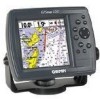
GPSMAP 172/172C chartplotting receiver owner's manual
GPSMAP 172/172C chartplotting receiver owner's manual
Owner's Manual
Page 2
... Road, Shijr, Taipei County, Taiwan Tel. 886/2.2642.9199 Fax 886/2.2642.9099 All rights reserved. Except as expressly provided herein, no part of this manual may not be used without notice. Garmin®, GPSMAP®, AutoLocate®, TracBack®, BlueChart®, and MapSource® are trademarks of this and other...
... Road, Shijr, Taipei County, Taiwan Tel. 886/2.2642.9199 Fax 886/2.2642.9099 All rights reserved. Except as expressly provided herein, no part of this manual may not be used without notice. Garmin®, GPSMAP®, AutoLocate®, TracBack®, BlueChart®, and MapSource® are trademarks of this and other...
Owner's Manual
Page 3
...or a photocopy, in this area to create an unsurpassed marine navigation chartplotter. In the USA contact Garmin Product Support by completing our online registration today! This manual covers instructions for the GPSMAP 172 and GPSMAP 172C (color). You further acknowledge that the structure, organization, and... Garmin Chartplotters" (190-00241-03). The Garmin GPSMAP 172/172C models utilize the proven performance of Garmin GPS and full-featured mapping to record the serial number (8-digit number located on the back of the product name) in Garmin. To get the most advanced marine ...
...or a photocopy, in this area to create an unsurpassed marine navigation chartplotter. In the USA contact Garmin Product Support by completing our online registration today! This manual covers instructions for the GPSMAP 172 and GPSMAP 172C (color). You further acknowledge that the structure, organization, and... Garmin Chartplotters" (190-00241-03). The Garmin GPSMAP 172/172C models utilize the proven performance of Garmin GPS and full-featured mapping to record the serial number (8-digit number located on the back of the product name) in Garmin. To get the most advanced marine ...
Owner's Manual
Page 8
...; Cigarette Lighter Adapter • BlueChart Marine Data Cards, MapSource CDs, USB Data Card Programmer, and Data Cards • GSD 20 Remote Sounder Module • GBR 23 Beacon Receiver for differential corrections Introduction Packing List vi Before installing and getting started with remote antenna. Standard Package: • GPSMAP 172/172C Unit • GA 29 Remote...
...; Cigarette Lighter Adapter • BlueChart Marine Data Cards, MapSource CDs, USB Data Card Programmer, and Data Cards • GSD 20 Remote Sounder Module • GBR 23 Beacon Receiver for differential corrections Introduction Packing List vi Before installing and getting started with remote antenna. Standard Package: • GPSMAP 172/172C Unit • GA 29 Remote...
Owner's Manual
Page 20
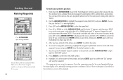
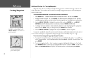
You see a grid of available waypoint symbols to select from a list of this manual. If you make a mistake and select an incorrect character, simply press LEFT on the ARROW KEYPAD to backspace the cursor and then UP or DOWN ...to correct the entry. (If you accidentally press ENTER before you are two Diver Down waypoint symbols to choose from the map display or by manually entering position coordinates. The waypoint is now stored in thes reference section of useful symbols. Note that just the first '0' is described in memory. versions...
You see a grid of available waypoint symbols to select from a list of this manual. If you make a mistake and select an incorrect character, simply press LEFT on the ARROW KEYPAD to backspace the cursor and then UP or DOWN ...to correct the entry. (If you accidentally press ENTER before you are two Diver Down waypoint symbols to choose from the map display or by manually entering position coordinates. The waypoint is now stored in thes reference section of useful symbols. Note that just the first '0' is described in memory. versions...
Owner's Manual
Page 27
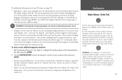
... reference section of the GPSMAP 172/172C in your home waters. For detailed instructions on the ARROW KEYPAD until the screen is a powerful tool with Garmin Chartplotters" (190-00241-03) for sonar operations. The next section of the manual describes the pages and functions of this manual. This ensures that you... ARROW KEYPAD and you shut it 's 'Normal' operation mode when you see a list of stored waypoints appear to the right of the Garmin GPSMAP 172/172C. When the screen is still in the Getting Started tour. To get a basic feel for how the Main Menu page works, let's...
... reference section of the GPSMAP 172/172C in your home waters. For detailed instructions on the ARROW KEYPAD until the screen is a powerful tool with Garmin Chartplotters" (190-00241-03) for sonar operations. The next section of the manual describes the pages and functions of this manual. This ensures that you... ARROW KEYPAD and you shut it 's 'Normal' operation mode when you see a list of stored waypoints appear to the right of the Garmin GPSMAP 172/172C. When the screen is still in the Getting Started tour. To get a basic feel for how the Main Menu page works, let's...
Owner's Manual
Page 40
...new waypoint's coordinates manually (from a chart, etc.). To accept the waypoint with a user-defined icon, comments, depth, and water temperature available for the name. 4. Waypoints can be created using the ARROW KEYPAD. • Text Entry- Marking Your Present Position The Garmin GPSMAP 172/172C's ENTER/MARK key ...lets you to select a map position or map item from the map display using three basic methods: • ENTER/MARK key- This can be determined by looking at the GPS tab on the Main Menu. ...
...new waypoint's coordinates manually (from a chart, etc.). To accept the waypoint with a user-defined icon, comments, depth, and water temperature available for the name. 4. Waypoints can be created using the ARROW KEYPAD. • Text Entry- Marking Your Present Position The Garmin GPSMAP 172/172C's ENTER/MARK key ...lets you to select a map position or map item from the map display using three basic methods: • ENTER/MARK key- This can be determined by looking at the GPS tab on the Main Menu. ...
Owner's Manual
Page 41
... change the name, symbol, position, or add a comment, depth, or water temp, highlight the appropriate field and press ENTER. To manually enter a set of that map feature appears. The GPSMAP 172/172C uses the map item text shown on the map feature), highlight 'OK' and press ENTER. Press and quickly release the ENTER...
... change the name, symbol, position, or add a comment, depth, or water temp, highlight the appropriate field and press ENTER. To manually enter a set of that map feature appears. The GPSMAP 172/172C uses the map item text shown on the map feature), highlight 'OK' and press ENTER. Press and quickly release the ENTER...
Owner's Manual
Page 42
... field and use the ARROW KEYPAD to save the waypoint. The 'New Waypoint' page appears, with the next available waypoint number and the receiver's last know position as the default name and position. 3. Make your current location, be created by "projecting" the distance and bearing from... the position field and press ENTER. Highlight the 'Points' tab and press MENU. 2. Highlight 'Create Waypoint' and press ENTER. Start by manually entering position coordinates through the Points tab of the word 'From' reads 'Current Position' (if not, highlight the field and press ENTER, ...
... field and use the ARROW KEYPAD to save the waypoint. The 'New Waypoint' page appears, with the next available waypoint number and the receiver's last know position as the default name and position. 3. Make your current location, be created by "projecting" the distance and bearing from... the position field and press ENTER. Highlight the 'Points' tab and press MENU. 2. Highlight 'Create Waypoint' and press ENTER. Start by manually entering position coordinates through the Points tab of the word 'From' reads 'Current Position' (if not, highlight the field and press ENTER, ...
Owner's Manual
Page 59
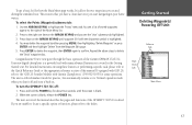
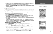
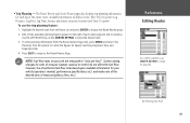
..., Leg Fuel, Leg Time, Sunrise and Sunset (at point location) and Time To (point). Reference Editing Routes Press LEFT or RIGHT on your vehicle (operator's manual, performance specifications, etc.) and make note of the desired units of measure (gallons, liters, etc.). Highlight the desired route from the options list. Enter the...
..., Leg Fuel, Leg Time, Sunrise and Sunset (at point location) and Time To (point). Reference Editing Routes Press LEFT or RIGHT on your vehicle (operator's manual, performance specifications, etc.) and make note of the desired units of measure (gallons, liters, etc.). Highlight the desired route from the options list. Enter the...
Owner's Manual
Page 66
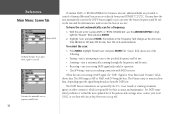
... mode. Unit is tuning manual DGPS frequency • Receiving Beacon - the receiver is unusable, possibly due to five minutes. • Acquiring Satellites - DGPS receiver attached, but has not collected enough data to calculate a fix. • 2D - Indicates a Differential signal is being corrected. • 3D - Reference Main Menu: GPS Tab When the GPSMAP 172/172C is using a differential...
... mode. Unit is tuning manual DGPS frequency • Receiving Beacon - the receiver is unusable, possibly due to five minutes. • Acquiring Satellites - DGPS receiver attached, but has not collected enough data to calculate a fix. • 2D - Indicates a Differential signal is being corrected. • 3D - Reference Main Menu: GPS Tab When the GPSMAP 172/172C is using a differential...
Owner's Manual
Page 67
...relating to the unit and Garmin DGPS, RTCM In/NMEA Out, or Other DGPS is enable on Port 2, WAAS is automatically disabled (WAAS Off). Retail Demo mode restores factory settings to the unit if left unattended for display purposes. allows you to manually enter the elevation when ...Simulator- Any elevation entered is automatically calculated when the GPS is not possible for the GPSMAP 172/172C to 0-30db with 30db being the best, the strength of the DGPS signal being received. toggles the WAAS capability of the receiver on a scale to receive WAAS and DGPS corrections at the same time. ...
...relating to the unit and Garmin DGPS, RTCM In/NMEA Out, or Other DGPS is enable on Port 2, WAAS is automatically disabled (WAAS Off). Retail Demo mode restores factory settings to the unit if left unattended for display purposes. allows you to manually enter the elevation when ...Simulator- Any elevation entered is automatically calculated when the GPS is not possible for the GPSMAP 172/172C to 0-30db with 30db being the best, the strength of the DGPS signal being received. toggles the WAAS capability of the receiver on a scale to receive WAAS and DGPS corrections at the same time. ...
Owner's Manual
Page 81
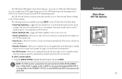
...'Grid' and 'User Mag Var'. 'Auto Mag Var' provides magnetic north heading references which are being used in the unit. Use the ARROW KEYPAD to manually select the datum reference used in Feet (ft), Fathoms (fa) or Meters (m). • Temperature - allows you select the desired units of measure for ... navigation information is 'WGS 84'. The unit automatically chooses the best datum depending upon a true north reference. 'Grid' provides headings based on your GPS, make sure the settings under the 'Units' tab of the GPSMAP 172/172C match that specifies a different datum.
...'Grid' and 'User Mag Var'. 'Auto Mag Var' provides magnetic north heading references which are being used in the unit. Use the ARROW KEYPAD to manually select the datum reference used in Feet (ft), Fathoms (fa) or Meters (m). • Temperature - allows you select the desired units of measure for ... navigation information is 'WGS 84'. The unit automatically chooses the best datum depending upon a true north reference. 'Grid' provides headings based on your GPS, make sure the settings under the 'Units' tab of the GPSMAP 172/172C match that specifies a different datum.
Owner's Manual
Page 84
...frequency and bit rate on the unit and the information is responsible for their web site at 6-second intervals. With the unit set to 'Garmin DGPS' or 'RTCM In/NMEA Out', use the ARROW KEYPAD to find the most updated list of the following: • Tuning - ...field shows one of frequencies and coverage areas, contact your GPSMAP 172/172C. The DGPS beacon transmitters are provided to tune the beacon receiver. You may have the unit automatically scan for operation. • Check Wiring - The Distance may or may also manually enter a frequency and bit rate. Coast Guard (or...
...frequency and bit rate on the unit and the information is responsible for their web site at 6-second intervals. With the unit set to 'Garmin DGPS' or 'RTCM In/NMEA Out', use the ARROW KEYPAD to find the most updated list of the following: • Tuning - ...field shows one of frequencies and coverage areas, contact your GPSMAP 172/172C. The DGPS beacon transmitters are provided to tune the beacon receiver. You may have the unit automatically scan for operation. • Check Wiring - The Distance may or may also manually enter a frequency and bit rate. Coast Guard (or...
Owner's Manual
Page 97
...60529-IPX-7 Temp. Physical Specifications Size: 4.9" H x 6.3" W x 3.7" D (122.5mm x 157.5mm x 92.5mm) Weight: 1.0 lb 1oz.(.481Kg) Display: (172C) 3.2" W x 3.2" H (81.28mm) CSTN (Color Super Twist Nematic) with adjustable CCFL (Cold Cathode Fluorescent Lamp) backlighting; (320x320 pixels) (172) . 3.2" W x...) Case: Fully gasketed, high-impact plastic alloy, waterproof to 55°C) Performance Receiver: Differential-ready 12 parallel channel WAAS capable receiver Acquisition Times: Warm: Approx. 15 seconds Cold: Approx. 45 seconds AutoLocate: Approx. ...
...60529-IPX-7 Temp. Physical Specifications Size: 4.9" H x 6.3" W x 3.7" D (122.5mm x 157.5mm x 92.5mm) Weight: 1.0 lb 1oz.(.481Kg) Display: (172C) 3.2" W x 3.2" H (81.28mm) CSTN (Color Super Twist Nematic) with adjustable CCFL (Cold Cathode Fluorescent Lamp) backlighting; (320x320 pixels) (172) . 3.2" W x...) Case: Fully gasketed, high-impact plastic alloy, waterproof to 55°C) Performance Receiver: Differential-ready 12 parallel channel WAAS capable receiver Acquisition Times: Warm: Approx. 15 seconds Cold: Approx. 45 seconds AutoLocate: Approx. ...

