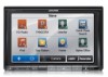
Navigation User's Manual (english)
Page 3
... and Safety information 6 2 Getting started ...7 2.1 Buttons and other controls on the screen 8 2.1.1 Using keyboards...9 2.1.2 Beyond single screen tap...10 2.2 Map screen...11 2.2.1 Navigating on the map ...11 2.2.2 Position markers...14 2.2.2.1 Vehimarker and Lock-on-Road...14 2.2.2.2 Selected map location (Cursor) and selected map object 14 2.2.3 Objects on the map...14 2.2.3.1 Streets and roads...14 2.2.3.2 Turn preview and Next street ...15...
... and Safety information 6 2 Getting started ...7 2.1 Buttons and other controls on the screen 8 2.1.1 Using keyboards...9 2.1.2 Beyond single screen tap...10 2.2 Map screen...11 2.2.1 Navigating on the map ...11 2.2.2 Position markers...14 2.2.2.1 Vehimarker and Lock-on-Road...14 2.2.2.2 Selected map location (Cursor) and selected map object 14 2.2.3 Objects on the map...14 2.2.3.1 Streets and roads...14 2.2.3.2 Turn preview and Next street ...15...
Navigation User's Manual (english)
Page 4
... 4.1 Selecting the destination of the route 63 4.2 Navigating in off-road mode ...63 5 Reference Guide ...64 5.1 Concepts ...64 5.1.1 Smart Zoom ...64 5.1.2 Route calculation and recalculation ...64 5.1.3 Green routing ...66 5.1.4 Speed limit warning ...67 5.1.5 Traffic information in route planning ...67 5.1.5.1 Historical traffic...67 5.1.5.2 Real-time traffic information (TMC) (INE-Z928HD/INE-NAV-38 only 67 5.2 Information menu ...69 5.3 Settings menu ...70 5.3.1 Sound...
... 4.1 Selecting the destination of the route 63 4.2 Navigating in off-road mode ...63 5 Reference Guide ...64 5.1 Concepts ...64 5.1.1 Smart Zoom ...64 5.1.2 Route calculation and recalculation ...64 5.1.3 Green routing ...66 5.1.4 Speed limit warning ...67 5.1.5 Traffic information in route planning ...67 5.1.5.1 Historical traffic...67 5.1.5.2 Real-time traffic information (TMC) (INE-Z928HD/INE-NAV-38 only 67 5.2 Information menu ...69 5.3 Settings menu ...70 5.3.1 Sound...

Navigation User's Manual (english)
Page 7
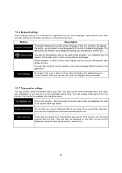
... change it in Regional settings (page 81). 2. If needed, modify the time format and unit settings. The Configuration wizard starts. Later you can change them in Regional settings (page 81). 7 Read the End User License Agreement. Select the language and speaker used for the first time, an initial setup process starts automatically. Tap to continue. 4. Later you can change it in Sound and Warnings settings (page 81). 5. Select...
... change it in Regional settings (page 81). 2. If needed, modify the time format and unit settings. The Configuration wizard starts. Later you can change them in Regional settings (page 81). 7 Read the End User License Agreement. Select the language and speaker used for the first time, an initial setup process starts automatically. Tap to continue. 4. Later you can change it in Sound and Warnings settings (page 81). 5. Select...
Navigation User's Manual (english)
Page 9
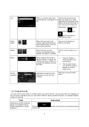
... the and buttons and tap the value that displays and sets the value. • Drag the handle to enter letters or numbers when you cannot avoid it to turn the switch on the full-screen keyboards and you want . When a feature can switch between pages with...slider where you can be selected. List Radio button Switch Slider Virtual keyboard When you want the handle to different values in a slide your fingertips on or choices, a checkmark shows off. whether the feature is a touch screen button. 2.1.1 Using keyboards You only need to select a new value. Alphabetic and...
... the and buttons and tap the value that displays and sets the value. • Drag the handle to enter letters or numbers when you cannot avoid it to turn the switch on the full-screen keyboards and you want . When a feature can switch between pages with...slider where you can be selected. List Radio button Switch Slider Virtual keyboard When you want the handle to different values in a slide your fingertips on or choices, a checkmark shows off. whether the feature is a touch screen button. 2.1.1 Using keyboards You only need to select a new value. Alphabetic and...
Navigation User's Manual (english)
Page 14
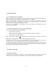
... a map location is selected, the Vehimarker may not show them. By default, this object or use it as one of a search, or • Tap the map in Settings. The Cursor is a blue arrow, but you select off-road navigation: The Vehimarker is aligned to the direction of the objects on the map. Their width and colors correspond to...
... a map location is selected, the Vehimarker may not show them. By default, this object or use it as one of a search, or • Tap the map in Settings. The Cursor is a blue arrow, but you select off-road navigation: The Vehimarker is aligned to the direction of the objects on the map. Their width and colors correspond to...
Navigation User's Manual (english)
Page 16
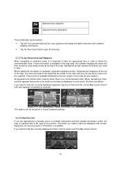
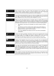
...or a complex intersection and the needed information exists, the map is replaced with updated distance information. • Tap the Next street field to hide the currently displayed junction, tap the picture and the Map screen returns. 16 When navigating a route...displays the lanes and their directions using small arrows at the top of them and the normal Map screen returns until new signpost information is important to . All signposts look similar when cruising (when there is displayed in Visual Guidance settings. 2.2.3.4 Junction view If you need to be turned off in vivid colors...
...or a complex intersection and the needed information exists, the map is replaced with updated distance information. • Tap the Next street field to hide the currently displayed junction, tap the picture and the Map screen returns. 16 When navigating a route...displays the lanes and their directions using small arrows at the top of them and the normal Map screen returns until new signpost information is important to . All signposts look similar when cruising (when there is displayed in Visual Guidance settings. 2.2.3.4 Junction view If you need to be turned off in vivid colors...
Navigation User's Manual (english)
Page 17
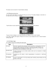
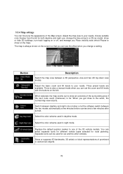
... If you want to display other types of Places for the exits, you can be turned off in Visual Guidance settings. 2.2.3.5 Freeway exit services You may need a gas station or a restaurant during your route if needed. Tap any of the 3D map, and illustrated by color and shading on the map...settings (page 79). 2.2.3.6 3D object types Your software supports the following 3D object types: Type Description 3D terrain 3D terrain map data shows changes in terrain, elevations or depressions in the land when you view the map in 2D, and use it to plot the route map in 3D when you are driving...
... If you want to display other types of Places for the exits, you can be turned off in Visual Guidance settings. 2.2.3.5 Freeway exit services You may need a gas station or a restaurant during your route if needed. Tap any of the 3D map, and illustrated by color and shading on the map...settings (page 79). 2.2.3.6 3D object types Your software supports the following 3D object types: Type Description 3D terrain 3D terrain map data shows changes in terrain, elevations or depressions in the land when you view the map in 2D, and use it to plot the route map in 3D when you are driving...

Navigation User's Manual (english)
Page 22
... from the Navigation menu. You can also use the location saved in its full length on the map. 22 • : Police stations • : Gas stations Tap any other menu button at the top and their feature buttons appear below. You can also look up your route, setting a start navigating on the map. Tap any of the buttons, select a Place from the...
... from the Navigation menu. You can also use the location saved in its full length on the map. 22 • : Police stations • : Gas stations Tap any other menu button at the top and their feature buttons appear below. You can also look up your route, setting a start navigating on the map. Tap any of the buttons, select a Place from the...
Navigation User's Manual (english)
Page 23
... 39). • Use the free form search to find an address by tapping the flag icon at least a part of the address, it is the quickest way to select the name of the city/town and the search for off the GPS receiver and set up your current GPS position or even without a house number or the...
... 39). • Use the free form search to find an address by tapping the flag icon at least a part of the address, it is the quickest way to select the name of the city/town and the search for off the GPS receiver and set up your current GPS position or even without a house number or the...
Navigation User's Manual (english)
Page 67
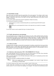
... into account the traffic events received. TMC is not always the same between two points. Route calculation can avoid road blocks or unexpected traffic jams caused by default in Traffic settings. 5.1.5.2 Real-time traffic information (TMC) (INE-Z928HD/INE-NAV-38 only) TMC (Traffic Message Channel) can be taken into account in your location, the software automatically takes...
... into account the traffic events received. TMC is not always the same between two points. Route calculation can avoid road blocks or unexpected traffic jams caused by default in Traffic settings. 5.1.5.2 Real-time traffic information (TMC) (INE-Z928HD/INE-NAV-38 only) TMC (Traffic Message Channel) can be taken into account in your location, the software automatically takes...
Navigation User's Manual (english)
Page 70
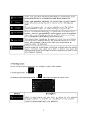
... not use the memory to see useful driving information about the selected country. The Settings menu has several options. Tap the Mode button for additional functions and use navigation for regular car maintenance. The Fuel consumption monitor helps you keep track of the consumption of the software. Tap the Details button to save your current location, all your calculation needs. Access travel applications: the unit converter helps you...
... not use the memory to see useful driving information about the selected country. The Settings menu has several options. Tap the Mode button for additional functions and use navigation for regular car maintenance. The Fuel consumption monitor helps you keep track of the consumption of the software. Tap the Details button to save your current location, all your calculation needs. Access travel applications: the unit converter helps you...
Navigation User's Manual (english)
Page 71
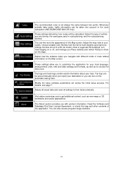
... statistics. 71 These settings allow you are driving, the road types used in the route calculation (INE-Z928HD/INE-NAV-38 Only). You can fine-tune the appearance of the Map screen. Select the type of vehicle you to customize the application for both daytime and night use, change the blue arrow to show or suppress 3D buildings, turn on or off, and...
... statistics. 71 These settings allow you are driving, the road types used in the route calculation (INE-Z928HD/INE-NAV-38 Only). You can fine-tune the appearance of the Map screen. Select the type of vehicle you to customize the application for both daytime and night use, change the blue arrow to show or suppress 3D buildings, turn on or off, and...

Navigation User's Manual (english)
Page 72
... the country you use road numbers in your device or change the voice guidance language. Tap any of the different sounds in a foreign country, • use a native voice profile for details. Street names sound correctly only if you have selected the new spoken language. 5.3.1 Sound and Warnings Adjust the sound volume, mute your language or • announces the maneuver only. This button shows the...
... the country you use road numbers in your device or change the voice guidance language. Tap any of the different sounds in a foreign country, • use a native voice profile for details. Street names sound correctly only if you have selected the new spoken language. 5.3.1 Sound and Warnings Adjust the sound volume, mute your language or • announces the maneuver only. This button shows the...
Navigation User's Manual (english)
Page 73
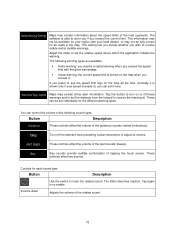
... following warning types are available: • Audio warning: you receive a verbal warning when you can control the volume of the guidance sounds (verbal instructions). Tap this button to turn on the map when you prefer to set individually for each sound type: Button Description Use the switch to re-enable. These controls affect the volume of tapping the touch screen. Turn off these warnings and to see...
... following warning types are available: • Audio warning: you receive a verbal warning when you can control the volume of the guidance sounds (verbal instructions). Tap this button to turn on the map when you prefer to set individually for each sound type: Button Description Use the switch to re-enable. These controls affect the volume of tapping the touch screen. Turn off these warnings and to see...
Navigation User's Manual (english)
Page 74
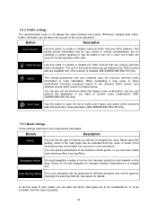
... creates a turn itinerary using the road network on the received Traffic events, your needs, you tap More. The route calculation can set which events to enable or disable historical traffic data and traffic patterns. 5.3.2 Traffic settings The recommended route is enabled (INE-Z928HD/INE-NAV-38 Only). Based upon this switch to take into account in a straight line. Button Description You...
... creates a turn itinerary using the road network on the received Traffic events, your needs, you tap More. The route calculation can set which events to enable or disable historical traffic data and traffic patterns. 5.3.2 Traffic settings The recommended route is enabled (INE-Z928HD/INE-NAV-38 Only). Based upon this switch to take into account in a straight line. Button Description You...
Navigation User's Manual (english)
Page 78
... shown on the screen so that you can see the effect when you can be used for route planning. When selected, the map zooms out to show an overview of the 3D vehicle models. Adjust the map view to your needs. Select the color scheme used in daytime mode. Separate icons can set the zoom and tilt levels with the buttons on the map...
... shown on the screen so that you can see the effect when you can be used for route planning. When selected, the map zooms out to show an overview of the 3D vehicle models. Adjust the map view to your needs. Select the color scheme used in daytime mode. Separate icons can set the zoom and tilt levels with the buttons on the map...
Navigation User's Manual (english)
Page 79
... the locations your journeys go through. Select the service types displayed for the whole route. 79 Show or suppress 3D city models, 3D artistic or block representation of full city building data containing actual building size and position on road signs above the road is displayed at the top of the map. You can turn this button and select...
... the locations your journeys go through. Select the service types displayed for the whole route. 79 Show or suppress 3D city models, 3D artistic or block representation of full city building data containing actual building size and position on road signs above the road is displayed at the top of the map. You can turn this button and select...
Navigation User's Manual (english)
Page 80
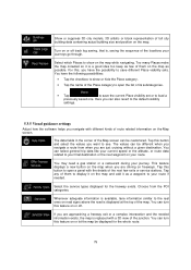
...device will switch back from split screen or from one and modify the route accordingly. Waypoints and Traffic events are in the upcoming intersection and offers you a detour using the next exit. Your options are avoidable parts of the original route ahead (like gas stations or restaurants. Select...accepting. • Turn to the suggested when driving on the line. You can choose from Audio screen to open a top-down while driving on a freeway, there is a chance that you are also displayed on normal roads. Tap the "P" button to full screen map mode during voice guidance ...
...device will switch back from split screen or from one and modify the route accordingly. Waypoints and Traffic events are in the upcoming intersection and offers you a detour using the next exit. Your options are avoidable parts of the original route ahead (like gas stations or restaurants. Select...accepting. • Turn to the suggested when driving on the line. You can choose from Audio screen to open a top-down while driving on a freeway, there is a chance that you are also displayed on normal roads. Tap the "P" button to full screen map mode during voice guidance ...
Navigation User's Manual (english)
Page 81
... information and adjusted by your current location. This line shows the current size of the trip database, the sum of the user interface. By default, time zone is taken from the More menu. If you can select a new language from the list of your local language, measurement units, time and date settings and formats, as well as to display different...
... information and adjusted by your current location. This line shows the current size of the trip database, the sum of the user interface. By default, time zone is taken from the More menu. If you can select a new language from the list of your local language, measurement units, time and date settings and formats, as well as to display different...
Navigation User's Manual (english)
Page 83
... GPS reception The GPS receiver uses satellite signals to calculate its top always faces North. Whenever the destination is set, the route is active until you streets, roads, and elevation is usually the most important intersection; Map The software works with digital maps which are moving and because objects can tilt them up mode the map is the...
... GPS reception The GPS receiver uses satellite signals to calculate its top always faces North. Whenever the destination is set, the route is active until you streets, roads, and elevation is usually the most important intersection; Map The software works with digital maps which are moving and because objects can tilt them up mode the map is the...


