Manual - English
Page 1
Magellan eXplorist 500 Reference Manual Topics: • eXplorist 500 GPS Receiver • Using the eXplorist 500 • Starting Up • Navigation Screens • File Structure • Points of Interest • Routes • Track Logs • Advanced Features • Magellan Geocache Manager • Using MapSend • Preferences • Specifications • Accessories • Contacting Magellan Support
Magellan eXplorist 500 Reference Manual Topics: • eXplorist 500 GPS Receiver • Using the eXplorist 500 • Starting Up • Navigation Screens • File Structure • Points of Interest • Routes • Track Logs • Advanced Features • Magellan Geocache Manager • Using MapSend • Preferences • Specifications • Accessories • Contacting Magellan Support
Manual - English
Page 2
...than the purchaser's personal use , copy, modify, reverse engineer or transfer this guide may severely degrade performance or damage the receiver, and will void the warranty. government and is protected by any interference, including interference that is operated by Thales Navigation ...U.S. USE CARE The Global Positioning System (GPS) is included with the Department of the device. © 2005 Thales S.A. The accuracy of this SOFTWARE except as buildings and large trees. Never rely solely on the Magellan® eXplorist™ while driving. LICENSE AGREEMENT Thales ...
...than the purchaser's personal use , copy, modify, reverse engineer or transfer this guide may severely degrade performance or damage the receiver, and will void the warranty. government and is protected by any interference, including interference that is operated by Thales Navigation ...U.S. USE CARE The Global Positioning System (GPS) is included with the Department of the device. © 2005 Thales S.A. The accuracy of this SOFTWARE except as buildings and large trees. Never rely solely on the Magellan® eXplorist™ while driving. LICENSE AGREEMENT Thales ...
Manual - English
Page 3
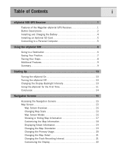
Table of Contents i eXplorist 500 GPS Receiver 1 Features of the Magellan eXplorist GPS Receiver 1 Button Descriptions 2 Installing and Charging the Battery 4 Installing an Optional SD Card 5 Connecting to a Personal Computer 5 Using the eXplorist 500 6 Going to a Destination 6 Saving Your Position 7 Tracing Your Steps 8 Additional Features 9 Summary 9 Starting Up 10 Turning the eXplorist On 10 Turning the eXplorist Off 10 Changing the Display Backlight...
Table of Contents i eXplorist 500 GPS Receiver 1 Features of the Magellan eXplorist GPS Receiver 1 Button Descriptions 2 Installing and Charging the Battery 4 Installing an Optional SD Card 5 Connecting to a Personal Computer 5 Using the eXplorist 500 6 Going to a Destination 6 Saving Your Position 7 Tracing Your Steps 8 Additional Features 9 Summary 9 Starting Up 10 Turning the eXplorist On 10 Turning the eXplorist Off 10 Changing the Display Backlight...
Manual - English
Page 7
Table of Contents v Preferences 88 Restarting the GPS 89 Using Active Setup 91 Changing the Default Files 91 Selecting...the Power Management Tool 97 Setting the Power-Off Timer 97 Setting the Light Timer 98 Personalizing the eXplorist 99 Selecting Languages 100 Clearing Memory 101 Clearing Active Track History 101 Clearing User-Entered POIs and ...Routes 102 Clearing Routes 102 Clearing Active Track, User-Entered POIs, and Routes 102 Reseting the eXplorist to Factory Defaults 103 Setting Alarms & Beepers 104 Setting the Beeper 105 Setting Alarms 105 Setting the Clock ...
Table of Contents v Preferences 88 Restarting the GPS 89 Using Active Setup 91 Changing the Default Files 91 Selecting...the Power Management Tool 97 Setting the Power-Off Timer 97 Setting the Light Timer 98 Personalizing the eXplorist 99 Selecting Languages 100 Clearing Memory 101 Clearing Active Track History 101 Clearing User-Entered POIs and ...Routes 102 Clearing Routes 102 Clearing Active Track, User-Entered POIs, and Routes 102 Reseting the eXplorist to Factory Defaults 103 Setting Alarms & Beepers 104 Setting the Beeper 105 Setting Alarms 105 Setting the Clock ...
Manual - English
Page 8
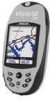
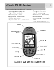
eXplorist 500 GPS Receiver 1 Features of the Magellan eXplorist GPS receiver: • Built-in background map (8 MB) • High-definition color display • Preloaded points of interest • Rugged design, rubber-protected • 8 MB of usable memory • Superior tracking with 14 parallel channels • Rechargeable Li-Ion battery • TrueFix™ GPS technology • 3 meter accuracy (WAAS/EGNOS) •...
eXplorist 500 GPS Receiver 1 Features of the Magellan eXplorist GPS receiver: • Built-in background map (8 MB) • High-definition color display • Preloaded points of interest • Rugged design, rubber-protected • 8 MB of usable memory • Superior tracking with 14 parallel channels • Rechargeable Li-Ion battery • TrueFix™ GPS technology • 3 meter accuracy (WAAS/EGNOS) •...
Manual - English
Page 9
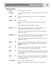
eXplorist 500 GPS Receiver 2 Button Descriptions: On/Off Backlight ENTER ESCAPE ZOOM IN ZOOM OUT MENU NAV MARK GOTO Arrow joystick Turns the eXplorist on or off to low to high intensity. Closes the accessed function and goes back to zoom out on the map displayed. Also used to ...
eXplorist 500 GPS Receiver 2 Button Descriptions: On/Off Backlight ENTER ESCAPE ZOOM IN ZOOM OUT MENU NAV MARK GOTO Arrow joystick Turns the eXplorist on or off to low to high intensity. Closes the accessed function and goes back to zoom out on the map displayed. Also used to ...
Manual - English
Page 10
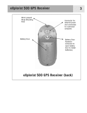
Battery Door Fastener (Unscrew to open battery door to a personal computer. eXplorist 500 GPS Receiver Wrist Lanyard Strap Mounting Hole Battery Door 3 Connector for external power and connection to install batteries.) eXplorist 500 GPS Receiver (back)
Battery Door Fastener (Unscrew to open battery door to a personal computer. eXplorist 500 GPS Receiver Wrist Lanyard Strap Mounting Hole Battery Door 3 Connector for external power and connection to install batteries.) eXplorist 500 GPS Receiver (back)
Manual - English
Page 11
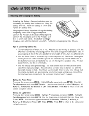
...with the backlight display on the batteries is constantly calculating position fixes and using your eXplorist. Highlight Preferences and press ENTER. Highlight Pwr Management and press ENTER twice. Press ENTER. eXplorist 500 GPS Receiver 4 Installing and Charging the Battery Installing the Battery: Remove the battery door by .... You should use of the buttons have been pressed and the computed location hasn't changed. The battery will automatically turn the eXplorist off . Use the down arrow to an AC wall outlet. Connect the PC cable to the back of the buttons have...
...with the backlight display on the batteries is constantly calculating position fixes and using your eXplorist. Highlight Preferences and press ENTER. Highlight Pwr Management and press ENTER twice. Press ENTER. eXplorist 500 GPS Receiver 4 Installing and Charging the Battery Installing the Battery: Remove the battery door by .... You should use of the buttons have been pressed and the computed location hasn't changed. The battery will automatically turn the eXplorist off . Use the down arrow to an AC wall outlet. Connect the PC cable to the back of the buttons have...
Manual - English
Page 12
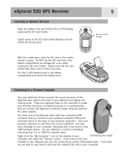
...flat in gray). The other end of your personal computer on and then turn on the connector to make sure that you connect the eXplorist to your personal computer USB ports (normally found a new USB hardware device. From here you will occur when closing the SD Card ... card installed in the battery compartment and secure the battery door. Put the LI-ION battery back in your eXplorist you are alignment tabs on your personal computer). eXplorist 500 GPS Receiver Installing an Optional SD Card Open the battery door and remove the LI-ION battery, exposing the SD Card ...
...flat in gray). The other end of your personal computer on and then turn on the connector to make sure that you connect the eXplorist to your personal computer USB ports (normally found a new USB hardware device. From here you will occur when closing the SD Card ... card installed in the battery compartment and secure the battery door. Put the LI-ION battery back in your eXplorist you are alignment tabs on your personal computer). eXplorist 500 GPS Receiver Installing an Optional SD Card Open the battery door and remove the LI-ION battery, exposing the SD Card ...
Manual - English
Page 13
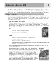
...receive the signals from the satellites. You need to do is to give your eXplorist a clear view of the sky so that you want to arrive at least four satellites with only three satellites is a GOTO route. To add elevation to your position fix, you need to go. Using the eXplorist 500 6 The eXplorist 500... uses information from the GPS satellites orbiting the earth to provide you with detailed information about your eXplorist. This is to use of the satellites and their relative signal...
...receive the signals from the satellites. You need to do is to give your eXplorist a clear view of the sky so that you want to arrive at least four satellites with only three satellites is a GOTO route. To add elevation to your position fix, you need to go. Using the eXplorist 500 6 The eXplorist 500... uses information from the GPS satellites orbiting the earth to provide you with detailed information about your eXplorist. This is to use of the satellites and their relative signal...

Manual - English
Page 30
... the name of the destination. • Press MENU and select Customize page to change the information displayed at least 0.5 mph for the compass to most GPS users. When there is no active route, the graphical compass performs like a standard compass, indicating to your heading as referenced to true north. (Note: You...
... the name of the destination. • Press MENU and select Customize page to change the information displayed at least 0.5 mph for the compass to most GPS users. When there is no active route, the graphical compass performs like a standard compass, indicating to your heading as referenced to true north. (Note: You...

Manual - English
Page 32
...fix. • Date and time are being used to seasoned navigators. It also displays a 'charging' icon when you have the eXplorist connected to keeps track of the distance you've travelled. • A graphical battery indicator provides you with information on how to ... is displayed. (Accurate when four or more satellites are shown, automatically adjusted from time information supplied from the atomic clocks in the GPS satellites. • A resettable trip odometer to external power. Navigation Screens 25 Position Screen The Position screen provides detailed position information in...
...fix. • Date and time are being used to seasoned navigators. It also displays a 'charging' icon when you have the eXplorist connected to keeps track of the distance you've travelled. • A graphical battery indicator provides you with information on how to ... is displayed. (Accurate when four or more satellites are shown, automatically adjusted from time information supplied from the atomic clocks in the GPS satellites. • A resettable trip odometer to external power. Navigation Screens 25 Position Screen The Position screen provides detailed position information in...
Manual - English
Page 35
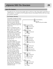
... is connected to your personal computer, you create new files in any of the file. eXplorist 500 File Structure 28 Basic File Structure The eXplorist has a file structure system that is internal to the eXplorist. This will make finding the POI or route much easier when you should do so to... mapping software, such as Magellan MapSend or geocache files from using any other filing system used before on the file system that you insert a new SD card, a similar file structure is created but without any of the file structure that is based on a GPS receiver. The Detail Maps and...
... is connected to your personal computer, you create new files in any of the file. eXplorist 500 File Structure 28 Basic File Structure The eXplorist has a file structure system that is internal to the eXplorist. This will make finding the POI or route much easier when you should do so to... mapping software, such as Magellan MapSend or geocache files from using any other filing system used before on the file system that you insert a new SD card, a similar file structure is created but without any of the file structure that is based on a GPS receiver. The Detail Maps and...

Manual - English
Page 38
... Waypoints and points of interest are identical.) There are called "Marking Your position" or just MARK for your eXplorist 500: POIs that you are two levels of marking your eXplorist so that you have heard the term "waypoints" to save the POI in and press ENTER. Sample Mark Screen...point for an afternoon sail, you are accessed from a detailed map. Points of Interest 31 Whether driving in a car, hiking on the trail, or out for any GPS navigator. These POIs are going to want to describe marked positions. This is called points of interest, or just POIs. ...
... Waypoints and points of interest are identical.) There are called "Marking Your position" or just MARK for your eXplorist 500: POIs that you are two levels of marking your eXplorist so that you have heard the term "waypoints" to save the POI in and press ENTER. Sample Mark Screen...point for an afternoon sail, you are accessed from a detailed map. Points of Interest 31 Whether driving in a car, hiking on the trail, or out for any GPS navigator. These POIs are going to want to describe marked positions. This is called points of interest, or just POIs. ...

Manual - English
Page 51
...instead.) An advantage of a multi-leg route is useful when you started. This route is that they are erased when the eXplorist is the most important functions of a GPS receiver. Features of a GOTO route: • A straight line from using your present position to a specific preloaded or userentered POI...the more enjoyment you understand routes and how to know that it can also be a single-leg route; The better you will receive from your eXplorist. GOTO Routes A GOTO route is turned off. • GOTO routes can be created by pressing the GOTO button and selecting the...
...instead.) An advantage of a multi-leg route is useful when you started. This route is that they are erased when the eXplorist is the most important functions of a GPS receiver. Features of a GOTO route: • A straight line from using your present position to a specific preloaded or userentered POI...the more enjoyment you understand routes and how to know that it can also be a single-leg route; The better you will receive from your eXplorist. GOTO Routes A GOTO route is turned off. • GOTO routes can be created by pressing the GOTO button and selecting the...
Manual - English
Page 83
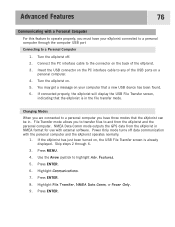
... Transfer screen, indicating that a new USB device has been found. 6. NMEA Data Comm mode outputs the GPS data from the eXplorist and the personal computer. Turn the eXplorist on , the USB File Transfer screen is in the file transfer mode. Changing Modes When you are connected... to a personal computer you have your computer that the eXplorist is already displayed. Skip steps 2 through the computer USB port Connecting to a Personal Computer 1. Press ENTER. 8. Power Only mode turns ...
... Transfer screen, indicating that a new USB device has been found. 6. NMEA Data Comm mode outputs the GPS data from the eXplorist and the personal computer. Turn the eXplorist on , the USB File Transfer screen is in the file transfer mode. Changing Modes When you are connected... to a personal computer you have your computer that the eXplorist is already displayed. Skip steps 2 through the computer USB port Connecting to a Personal Computer 1. Press ENTER. 8. Power Only mode turns ...

Manual - English
Page 90
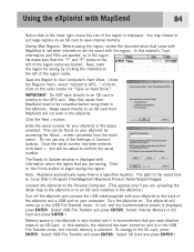
The core MapSend product line includes street maps for driving, topographic maps for hiking, camping, and hunting, and fresh/salt water maps for outdoor recreation and travel. MapSend maps will bring up a window for you purchased, the ... POIs, routes, map regions, etc. Following the instructions provided with the MapSend product you to the eXplorist Install MapSend Software. Using the eXplorist with MapSend 83 What is the Magellan line of detailed digital maps for Magellan hand-held GPS receivers. Using the Draw New Region tool, define the region. MapSend® is MapSend?
The core MapSend product line includes street maps for driving, topographic maps for hiking, camping, and hunting, and fresh/salt water maps for outdoor recreation and travel. MapSend maps will bring up a window for you purchased, the ... POIs, routes, map regions, etc. Following the instructions provided with the MapSend product you to the eXplorist Install MapSend Software. Using the eXplorist with MapSend 83 What is the Magellan line of detailed digital maps for Magellan hand-held GPS receivers. Using the Draw New Region tool, define the region. MapSend® is MapSend?
Manual - English
Page 91
... the Next > button. You will not work in the lower right corner the size of the region is recommended that in the eXplorist. The path to GPS..." (Ctrl+U). Before saving the region, review the documentation that came with MapSend 84 Notice that you are uploading the detail map to...USB File Transfer and press ENTER. You may choose to the GPS unit. This can be converted before using them in the region list make sure that the "T" and "P" boxes to Update window is : Local Disk C:\Program Files\Magellan\'MapSend Product Name'\Export\Images. Under the Regions menu, select "...
... the Next > button. You will not work in the lower right corner the size of the region is recommended that in the eXplorist. The path to GPS..." (Ctrl+U). Before saving the region, review the documentation that came with MapSend 84 Notice that you are uploading the detail map to...USB File Transfer and press ENTER. You may choose to the GPS unit. This can be converted before using them in the region list make sure that the "T" and "P" boxes to Update window is : Local Disk C:\Program Files\Magellan\'MapSend Product Name'\Export\Images. Under the Regions menu, select "...
Manual - English
Page 93
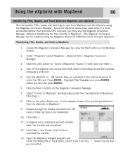
... through the folders and select the POI, route or track log files to be installed using the Magellan Conversion Manager. Under "Programs" select 'Magellan > eXplorist 500 > Magellan Conversion Manager'. 3. In the example shown, files are uploaded to the internal memory, to select ...Load from MapSend and the eXplorist using the Magellan Wizard CD-ROM that you must use the Magellan Conversion Manager instead of transferring the files directly in a more accessible manner than previous GPS receivers, you converted. Using the eXplorist with your eXplorist.) Transferring POIs, Routes,...
... through the folders and select the POI, route or track log files to be installed using the Magellan Conversion Manager. Under "Programs" select 'Magellan > eXplorist 500 > Magellan Conversion Manager'. 3. In the example shown, files are uploaded to the internal memory, to select ...Load from MapSend and the eXplorist using the Magellan Wizard CD-ROM that you must use the Magellan Conversion Manager instead of transferring the files directly in a more accessible manner than previous GPS receivers, you converted. Using the eXplorist with your eXplorist.) Transferring POIs, Routes,...
Manual - English
Page 95
... Preferences portion of the eXplorist provides the tools to personalize the eXplorist to your daylight savings requirements. There are tools that will provide you with the means to clear all or part of the internal memory. • Ability to set alarms to alert you when you have lost GPS signal, when you are... designed to give the eXplorist its use, as well as to tools that are getting near your destination, and other useful alerts. • A way of measure...
... Preferences portion of the eXplorist provides the tools to personalize the eXplorist to your daylight savings requirements. There are tools that will provide you with the means to clear all or part of the internal memory. • Ability to set alarms to alert you when you have lost GPS signal, when you are... designed to give the eXplorist its use, as well as to tools that are getting near your destination, and other useful alerts. • A way of measure...


