Magellan GPS 315 Support Question
Magellan GPS 315 Support Question
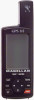
Find answers below for this question about Magellan GPS 315.Need a Magellan GPS 315 manual? We have 1 online manual for this item!
Question posted by Anonymous-42592 on November 11th, 2011
Magellan Gps 315 Will Not Find Satellites
When I turn on the GPS it says no pos
Current Answers
Related Magellan GPS 315 Manual Pages
User Manual - Page 2
... of position fixes can also be affected by the periodic adjustments to GPS satellites made by poor satellite geometry. All rights reserved.
The SOFTWARE is the property of Magellan Corporation. 630321 C therefore, you , the purchaser, the right to change in accordance with MAGELLAN GPS products (the "SOFTWARE") in and with the Department of the equipment. USE...
User Manual - Page 9
... needs. Introduction
Congratulations on your purchase of these items are also subchapters that the GPS 315 has a database of worldwide cities consisting of the world (North/ Central/South America, Europe/Africa and Australia/Asia). If any of the Magellan GPS 315/GPS 320 receiver. The Reference section contains information to you navigate using waypoints, routes and...
User Manual - Page 10
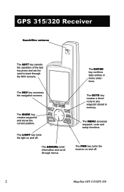
... ARROWs enter information and scroll through the NAV screens. The MARK key creates waypoints and stores the current position.
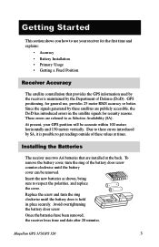
The PWR key turns the receiver on and off .
2
Magellan GPS 315/GPS 320 GPS 315/320 Receiver
Quadrifilar antenna
The QUIT key cancels the operation of the last key press and can be used to any waypoint...
User Manual - Page 11
...; Getting a Fixed Position
Receiver Accuracy
The satellite constellation that are installed at times. Insert the new batteries as Selective Availability (SA). To remove the battery cover, turn the ring clockwise until the battery cover can be accurate within 100 meters horizontally and 150 meters vertically.
Magellan GPS 315/GPS 320
3 Since the signals generated by these...
User Manual - Page 12
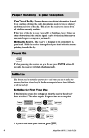
...satellites currently available. Initialize
You do not need to initialize your hand with the antenna pointing towards the sky. Initialize for First Time Use
If the Initialize screen does not appear, then the receiver has already been initialized. Hold the receiver in your elevation, press ENTER .
4
Magellan GPS 315/GPS...more than 300 miles while turned off automatically. Signal Reception
...
User Manual - Page 13
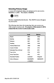
... HDG VMG CTS ETA TTG XTE Landmark MILES/MPH or KM/KPH
Marine SOG BRG DST COG VMG CTS ETA ETE XTE Waypoint NM/KNOTS
Magellan GPS 315/GPS 320
5
User Manual - Page 14
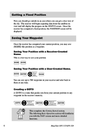
This is a route that guides you from the satellites in the receiver's memory. GOTO
Select category
ENTER
Select waypoint
ENTER
This .... The receiver will begin acquiring data from your current position, you with the NAV screens and more detailed functions.
6
Magellan GPS 315/GPS 320
MARK ENTER
Enter data
MARK
You can get a clear view of the sky. Creating a GOTO
A GOTO is ...
User Manual - Page 15
....
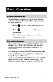
All screens, except STATUS and POSITION screens, can be viewed by turning them in SETUP as a navigational tool. Navigation Screens
The nine NAV ...turned on in mind while setting up or down.
• Use the
to move the cursor to the left or right and page
through menus.
• Press QUIT to return to the previous screen and to step through the sequence of SETUP. Magellan GPS 315/GPS...
User Manual - Page 16

... chart and on the Battery Life Indicator.
Using the Status Screen
The STATUS screen gives you will not be solid until ephemeris is 90˚.
8
Magellan GPS 315/GPS 320
The center of your position. When the receiver first tracks a satellite, the strength bar will have more battery life available than shown on the...
User Manual - Page 17
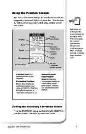
... coordinate system. You also have the option of your present position in a secondary coordinate system.
Once you are stationary, the receiver begins the averaging mode. Magellan GPS 315/GPS 320
9
Second Coordinate System
Access Displays your last computed position and basic navigation data. Viewing the Secondary Coordinate Screen
From the POSITION screen, use the...
User Manual - Page 18
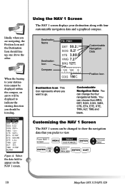
... Data You can choose from BRG, DST, SOG, COG, VMG, CTS, ETA, ETE, XTE, TRN, ALT, TME and
blank. A
Select data type
ENTER
QUIT
10
Magellan GPS 315/GPS 320
CWUPSTTONAMMIZEES
OBRFFG 027°m ODSNT 50.2nm SOG 8.2KT
COG 056°m
VMG 7.2KT
CTS 028°m
ETA 01:09P
ETE 02H24M
XTE L.2nm...
User Manual - Page 49
... is turned off ...satellites. INITIALIZE F ENTER
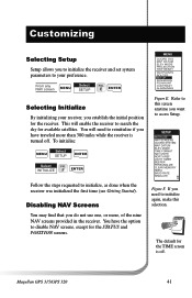
Follow the steps requested to access Setup.
Customizing
Selecting Setup
Setup allows you to initialize the receiver and set system parameters to your receiver, you establish the initial position for the receiver.
To initialize:
MENU
Select SETUP
ENTER
Select
FIG. From any NAV screen
MENU
Select SETUP
FIG. Magellan GPS 315/GPS...
User Manual - Page 57
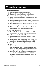
... you may wish to use of the sky and is in the map legend. Turn the backlight off when not needed.
Magellan GPS 315/GPS 320
49 Takes more than it should be due to a new location.
2. ...nearby or overhead, move to excessive use the same datum as your receiver.
2.
Check Satellite Status to fluctuate. Errors induced by the Department of the batteries can cause the elevation ...
User Manual - Page 58
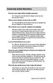
..., and most common cause is that you are in your receiver is diminished. Yes.
You say my receiver should work up to reset the time for changes in hundredths (00-99) and...are displayed, the full year designator is the time and date incorrect after tracking a satellite.
50
Magellan GPS 315/GPS 320 Even though the last two digits of an incorrect reading on the batteries causing the...
User Manual - Page 60
... (knots and KPH).
52
Magellan GPS 315/GPS 320
SET
OUTPUT/USAGE
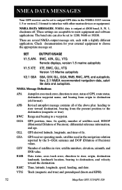
V1.5.APA BWC, APA, GLL, VTG Remote displays, version 1.5 marine autopilots
V1.5 XTE XTE, BWC, GLL, VTG Version 1.5 Marine autopilots
V2.1 GSA GSA, GSV, GLL, GGA, RMB, RMC, APB, and autopilots.
GPS-derived latitude, longitude, and time of satellites in view, satellite numbers, elevation, azimuth...
User Manual - Page 63
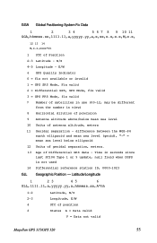
... valid
Magellan GPS 315/GPS 320
55 N/S 4-5 Longitude - difference between the WGS-84
earth ellipsoid and mean sea level (geoid), "-" = mean sea level below mean sea level 10 Units of Differential GPS data - E/W 6 GPS Quality Indicator 0 = fix not available or invalid 1 = GPS SPS Mode, Fix valid 2 = Differential GPS, SPS Mode, fix valid 3 = GPS PPS Mode, fix valid 7 Number of satellites...
User Manual - Page 64
... of messages, 1 to 9
2 Message number, 1 to 9
3 Total numer of satellites in view
4 Satellite PRN number
5 Elevation, degrees, 90° maximum
6 Azimuth, degrees True, 000 to... variable number of "PRN-Elevation-Azimuth-SNR" sets are transmitted.
56
Magellan GPS 315/GPS 320 GSA GPS DOP and Active Satellites
GPS receiver operating mode, satelites used in the navigation solution reported by the ...
User Manual - Page 67
...12 parallel-channel technology, tracks up to 12 satellites to 15 hours
Magellan GPS 315/GPS 320
59 Range:
Operating 14˚F to ...Rate 1 second continuous
Accuracy:
Position 49 feet (15 meters) RMS (with Selective Availability turned off )
Velocity 0.1 knot RMS steady state (with Selective Availability turned off )
Limits:
Speed 951 mph
Altitude 17,500 meters
Physical:
Size
6.2" x 2.0"...
User Manual - Page 71
... satellite. Leg (Route)
A segment of a route that has a fixed position and can be reached. Fixed Navaid
A navigation aid (usually found in water. B
A
Leg 1
Leg 2
D
Leg 3 C
Magellan GPS 315/GPS ... earth.
ETA
Estimated Time of 1 or more legs. Ephemeris
The position and velocity of the satellites in a route. ETE
Estimated Time Enroute. tower on land or a Greenday mark in marine ...
User Manual - Page 76
...Track Error XTE alarm see Cross Track Error alarm
U
Universal Time Coordinated (UTC) 20, 44
68
Magellan GPS 315/ GPS 320 naming 6; using Plot View in a route 32; functions 23; elapsed time 21 Track History ... changing a waypoint in a route 31; viewing 31
S
Satellite positions 8 Satellite signals 8 Setup 41 Shipping 51 Simulate Mode 9, 36 Sorting 26 Specifications 59 Speed screen 18; creating a message...
Similar Questions


Magellan Gps 315
how do i connect my magellan 315 to my laptop ??? i dont have any software ????
how do i connect my magellan 315 to my laptop ??? i dont have any software ????
(Posted by lozza47 11 years ago)

I Think I Broke My Gps 315
I was updating the firmware on my GPS 315 a couple of months ago and after an hour or so of updating...
I was updating the firmware on my GPS 315 a couple of months ago and after an hour or so of updating...
(Posted by godonkeys1 12 years ago)