Owner's Manual
Page 3
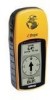
... by completing your new eTrex, take the time to read through this Owner's Manual to better support you can be found inside the battery compartment. Introduction Welcome To get the most out of your on the home page. This manual has been designed to our web site (www.garmin.com) and look for choosing the Garmin eTrex. On Your Mark. . . Thanks for...
... by completing your new eTrex, take the time to read through this Owner's Manual to better support you can be found inside the battery compartment. Introduction Welcome To get the most out of your on the home page. This manual has been designed to our web site (www.garmin.com) and look for choosing the Garmin eTrex. On Your Mark. . . Thanks for...
Owner's Manual
Page 5
... safe operating practices. Failure by the government of the United States, which could result in a safe manner, maintain full surveillance of the batteries. 3 CAUTION: IT IS THE USER'S RESPONSIBILITY TO USE THIS PRODUCT PRUDENTLY. THIS PRODUCT IS INTENDED TO BE USED ONLY AS A TRAVEL AID AND MUST NOT BE USED FOR ANY PURPOSE REQUIRING PRECISE MEASUREMENT OF DIRECTION, DISTANCE, LOCATION, OR...
... safe operating practices. Failure by the government of the United States, which could result in a safe manner, maintain full surveillance of the batteries. 3 CAUTION: IT IS THE USER'S RESPONSIBILITY TO USE THIS PRODUCT PRUDENTLY. THIS PRODUCT IS INTENDED TO BE USED ONLY AS A TRAVEL AID AND MUST NOT BE USED FOR ANY PURPOSE REQUIRING PRECISE MEASUREMENT OF DIRECTION, DISTANCE, LOCATION, OR...
Owner's Manual
Page 7
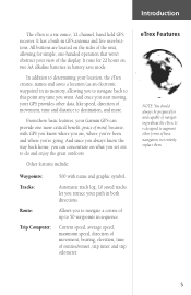
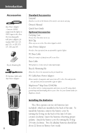
...: Waypoints: Tracks: Route: Trip Computer: 500 with GPS you know where you are located on what you set out to this point any time you start moving, your GPS provides other forms of movement, time and distance to determining your view of mind, because, with name and graphic symbol. Current speed, average speed, maximum speed, direction of movement, bearing, elevation, time of navigating without the eTrex. It is a six ounce, 12 channel, hand held GPS receiver...
...: Waypoints: Tracks: Route: Trip Computer: 500 with GPS you know where you are located on what you set out to this point any time you start moving, your GPS provides other forms of movement, time and distance to determining your view of mind, because, with name and graphic symbol. Current speed, average speed, maximum speed, direction of movement, bearing, elevation, time of navigating without the eTrex. It is a six ounce, 12 channel, hand held GPS receiver...
Owner's Manual
Page 10
... be mounted on your Garmin dealer for data input/output. PC Cable/Auto Power Adapter Allows transfer of the unit for Garmin VHF 720, 725, and 725e, or GPS 170, 175, 190, and 195. Bicycle Mounting Kit Allows the eTrex to an eTrex. See your PC using a background map and downloading them to a belt.. PC Data Cable Allows for creating waypoints and routes on a bicycle handle bar. Data Cable Wiring harness. Two AA alkaline batteries...
... be mounted on your Garmin dealer for data input/output. PC Cable/Auto Power Adapter Allows transfer of the unit for Garmin VHF 720, 725, and 725e, or GPS 170, 175, 190, and 195. Bicycle Mounting Kit Allows the eTrex to an eTrex. See your PC using a background map and downloading them to a belt.. PC Data Cable Allows for creating waypoints and routes on a bicycle handle bar. Data Cable Wiring harness. Two AA alkaline batteries...
Owner's Manual
Page 11
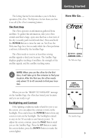
... 30 seconds to save battery power. The Satellite Page displays graphic tracking of satellites, the strength of the sky (a nearby park would work fine). The Satellite Page 9 Here We Go. . . Getting Started The Getting Started Section introduces you to find your location. The Reference Section shows you how to see the "READY TO NAVIGATE" message on the backlight. The First Step The eTrex operates on for...
... 30 seconds to save battery power. The Satellite Page displays graphic tracking of satellites, the strength of the sky (a nearby park would work fine). The Satellite Page 9 Here We Go. . . Getting Started The Getting Started Section introduces you to find your location. The Reference Section shows you how to see the "READY TO NAVIGATE" message on the backlight. The First Step The eTrex operates on for...
Owner's Manual
Page 12
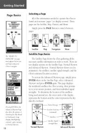
... PAGE Button to work. There are the Satellite, Map, Pointer, and Menu. Status Message Location Accuracy (estimated) Normal Skyview Satellites Satellite Signal Strength Bars Advanced Skyview These pages are two display options on the Advanced Skyview Page also offers the options of Orienting the Sky Ahead or Northward, Setup Display (backlighting/ contrast), and returning to navigate. This page displays the numbered satellites the eTrex is found on the Satellite Page, select 'Advanced...
... PAGE Button to work. There are the Satellite, Map, Pointer, and Menu. Status Message Location Accuracy (estimated) Normal Skyview Satellites Satellite Signal Strength Bars Advanced Skyview These pages are two display options on the Advanced Skyview Page also offers the options of Orienting the Sky Ahead or Northward, Setup Display (backlighting/ contrast), and returning to navigate. This page displays the numbered satellites the eTrex is found on the Satellite Page, select 'Advanced...
Owner's Manual
Page 14
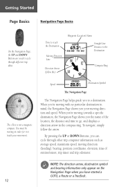
...), bearing, position coordinates, elevation, time of the location, the distance and time to go, and displays a direction arrow in the compass ring. To navigate, simply follow this) Waypoint (Location) Name Straight Line Distance to the Destination Compass Ring The eTrex is not a magnetic compass. When you're moving in mind, the Navigation Page shows you your movement. Speed Destination Symbol The Navigation Page The Navigation Page helps guide you can cycle through different trip data. Getting Started...
...), bearing, position coordinates, elevation, time of the location, the distance and time to go, and displays a direction arrow in the compass ring. To navigate, simply follow this) Waypoint (Location) Name Straight Line Distance to the Destination Compass Ring The eTrex is not a magnetic compass. When you're moving in mind, the Navigation Page shows you your movement. Speed Destination Symbol The Navigation Page The Navigation Page helps guide you can cycle through different trip data. Getting Started...
Owner's Manual
Page 15
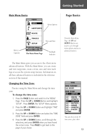
... to the 'MENU' Page. Press the UP or DOWN Button and select the 'TIME ZONE' field and press ENTER. 4. You can create and view waypoints, create a route, save and view track logs or access the system setup features. Information on all these advanced features is included in the reference section of your choice. To change the time zone. Press the PAGE Button and switch to the eTrex's more advanced features. Press the...
... to the 'MENU' Page. Press the UP or DOWN Button and select the 'TIME ZONE' field and press ENTER. 4. You can create and view waypoints, create a route, save and view track logs or access the system setup features. Information on all these advanced features is included in the reference section of your choice. To change the time zone. Press the PAGE Button and switch to the eTrex's more advanced features. Press the...
Owner's Manual
Page 16
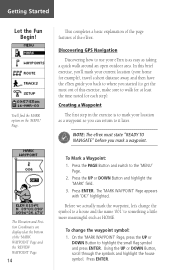
... Position Coordinates are displayed at least the time noted for example), travel a short distance away, and then have the eTrex guide you back to mark your home for each step). Using the UP or DOWN Button, scroll through the symbols and highlight the house symbol. highlighted. Before we actually mark the waypoint, let's change the waypoint symbol: 1. In this brief exercise, you'll mark your current location...
... Position Coordinates are displayed at least the time noted for example), travel a short distance away, and then have the eTrex guide you back to mark your home for each step). Using the UP or DOWN Button, scroll through the symbols and highlight the house symbol. highlighted. Before we actually mark the waypoint, let's change the waypoint symbol: 1. In this brief exercise, you'll mark your current location...

Owner's Manual
Page 18
...', and press ENTER. Press the UP or DOWN Button to the 'MENU' Page. 2. Walk in the Right Direction The eTrex will guide you back to where you are on track! 16 Guidance by Garmin The eTrex guides you to a destination using the Navigation Page. The 'REVIEW WAYPOINT' Page appears. 6. The arrow tells you should move right until the arrow points to the moving direction line (see...
...', and press ENTER. Press the UP or DOWN Button to the 'MENU' Page. 2. Walk in the Right Direction The eTrex will guide you back to where you are on track! 16 Guidance by Garmin The eTrex guides you to a destination using the Navigation Page. The 'REVIEW WAYPOINT' Page appears. 6. The arrow tells you should move right until the arrow points to the moving direction line (see...
Owner's Manual
Page 20
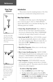
... north. • Auto Zoom On/Off: When 'AUTO ZOOM' is replaced by a 'direction' triangle. When you select 'Orient Map Northward' the figure icon is turned on, the map automatically adjusts its scale to display your destination. • Stop Navigation: 'STOP NAVIGATION' stops any active navigation (navigation means there is a 'MAP OPTIONS' feature which allows you to customize the Map Page. Press the UP or DOWN Button and highlight the desired option and press ENTER...
... north. • Auto Zoom On/Off: When 'AUTO ZOOM' is replaced by a 'direction' triangle. When you select 'Orient Map Northward' the figure icon is turned on, the map automatically adjusts its scale to display your destination. • Stop Navigation: 'STOP NAVIGATION' stops any active navigation (navigation means there is a 'MAP OPTIONS' feature which allows you to customize the Map Page. Press the UP or DOWN Button and highlight the desired option and press ENTER...

Owner's Manual
Page 22
... ENTER Button displays your location on the 'MARK WAYPOINT' Page. 20 Bearing-the compass direction from a computer to a destination. Trip Odometer-like the odometer in your present location. Main Menu Selections The Main Menu turns the eTrex into a powerful navigation tool. From the Main Menu you can customize the display, transfer information from your location to the eTrex and back again, and manage and organize all of your waypoints. The information on the data you want the eTrex to customize the eTrex's features. Elevation-the measurement...
... ENTER Button displays your location on the 'MARK WAYPOINT' Page. 20 Bearing-the compass direction from a computer to a destination. Trip Odometer-like the odometer in your present location. Main Menu Selections The Main Menu turns the eTrex into a powerful navigation tool. From the Main Menu you can customize the display, transfer information from your location to the eTrex and back again, and manage and organize all of your waypoints. The information on the data you want the eTrex to customize the eTrex's features. Elevation-the measurement...

Owner's Manual
Page 23
... Button and switch to edit the waypoint location. Press the UP or DOWN Button and highlight 'MARK'. The 'EDIT LOCATION' Page appears. 3. Press ENTER. The 'MARK WAYPOINT' Page appears. 2. Repeat until all numbers are now stored in memory. Mark Waypoint Page The 'EDIT LOCATION' Page displays on-screen instructions on how to the 'MENU' Page. To change the location (position coordinates): 1. Press ENTER. Using the UP or DOWN Button, scroll through the position places using the UP and DOWN Button (UP Button...
... Button and switch to edit the waypoint location. Press the UP or DOWN Button and highlight 'MARK'. The 'EDIT LOCATION' Page appears. 3. Press ENTER. The 'MARK WAYPOINT' Page appears. 2. Repeat until all numbers are now stored in memory. Mark Waypoint Page The 'EDIT LOCATION' Page displays on-screen instructions on how to the 'MENU' Page. To change the location (position coordinates): 1. Press ENTER. Using the UP or DOWN Button, scroll through the position places using the UP and DOWN Button (UP Button...

Owner's Manual
Page 31
... navigation later: 1. The saved track appears graphically on a saved track and press ENTER. A default name will be displayed. 4. The 'EDIT TRACK NAME' Page will be displayed on the 'TRACK LOG' Page. ) NOTE: Saving a Track Log does not remove those points from a specific time or save a track for saving a track or 'ENTIRE LOG'. When the name has been entered correctly, highlight 'OK' and press ENTER. Press the UP or DOWN Button and highlight 'TRACKS'. The track...
... navigation later: 1. The saved track appears graphically on a saved track and press ENTER. A default name will be displayed. 4. The 'EDIT TRACK NAME' Page will be displayed on the 'TRACK LOG' Page. ) NOTE: Saving a Track Log does not remove those points from a specific time or save a track for saving a track or 'ENTIRE LOG'. When the name has been entered correctly, highlight 'OK' and press ENTER. Press the UP or DOWN Button and highlight 'TRACKS'. The track...

Owner's Manual
Page 32
... change your destination. Press ENTER. Press ENTER. The 'NAVIGATION' Page guides you want to 'END'. The 'BEGIN-END' pair imply the direction of the saved track. On the 'TRACK LOG' Page, press the UP or DOWN Button and highlight the saved track that was saved. If you want to retrace the track, navigate to delete all tracks: 1. Press ENTER. Press the UP or DOWN Button and select the desired destination point. The direction...
... change your destination. Press ENTER. Press ENTER. The 'NAVIGATION' Page guides you want to 'END'. The 'BEGIN-END' pair imply the direction of the saved track. On the 'TRACK LOG' Page, press the UP or DOWN Button and highlight the saved track that was saved. If you want to retrace the track, navigate to delete all tracks: 1. Press ENTER. Press the UP or DOWN Button and select the desired destination point. The direction...
Owner's Manual
Page 36
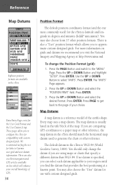
... overall knowledge of GPS. 34 Position Format The default position coordinates format (and the one most commonly used to generate the chart or other position formats. Press the PAGE Button and switch to the 'MENU' Page. Press the UP or DOWN Button and highlight 'SETUP'. Press ENTER. Press ENTER. Every map uses a map datum. Data Entry Pages exist for compatibility with custom-designed grids. Reference Map Datums Eighteen position formats are also excellent navigation and GPS articles available on...
... overall knowledge of GPS. 34 Position Format The default position coordinates format (and the one most commonly used to generate the chart or other position formats. Press the PAGE Button and switch to the 'MENU' Page. Press the UP or DOWN Button and highlight 'SETUP'. Press ENTER. Press ENTER. Every map uses a map datum. Data Entry Pages exist for compatibility with custom-designed grids. Reference Map Datums Eighteen position formats are also excellent navigation and GPS articles available on...
Owner's Manual
Page 47
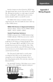
... 'SETUP' Page. The input/output lines on your eTrex to a wide range of external devices, including PC's, differential beacon receivers, marine autopilots and/or a second GPS receiver. NMEA 0183 Version 3.0 Approved Sentences: GPGGA, GPGLL, GPGSA, GPGSV, GPRMB, GPRMC, GPRTE, GPVTG, GPWPL, GPBOD Garmin Proprietary Sentences: PGRME (estimated error), PGRMM (datum string), PGRMZ (altitude), PSLIB (beacon receiver control) DGPS (Differential GPS) corrections are selected from the GPS unit. eTrex Connector Data Cable Data...
... 'SETUP' Page. The input/output lines on your eTrex to a wide range of external devices, including PC's, differential beacon receivers, marine autopilots and/or a second GPS receiver. NMEA 0183 Version 3.0 Approved Sentences: GPGGA, GPGLL, GPGSA, GPGSV, GPRMB, GPRMC, GPRTE, GPVTG, GPWPL, GPBOD Garmin Proprietary Sentences: PGRME (estimated error), PGRMM (datum string), PGRMZ (altitude), PSLIB (beacon receiver control) DGPS (Differential GPS) corrections are selected from the GPS unit. eTrex Connector Data Cable Data...
Owner's Manual
Page 49
... GPS satellites are owned by the United States Department of GPS satellite signals is accurate to everyone. Reception of Defense (DoD) and have the correct INPUT/OUTPUT format selected on the GPS unit can vary by U.S. Using differential techniques, the eTrex can 't I need to subscribe to a service to GPS altitude measurements. Another factor that will effect the accuracy of the GPS receiver. The altitude reading on your eTrex. Adjust the contrast (see the altitude...
... GPS satellites are owned by the United States Department of GPS satellite signals is accurate to everyone. Reception of Defense (DoD) and have the correct INPUT/OUTPUT format selected on the GPS unit can vary by U.S. Using differential techniques, the eTrex can 't I need to subscribe to a service to GPS altitude measurements. Another factor that will effect the accuracy of the GPS receiver. The altitude reading on your eTrex. Adjust the contrast (see the altitude...
Quick Start Guide
Page 1
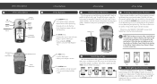
... are the SkyView, Map, Pointer, Trip Computer, and Menu. You'll see the SkyView Page. Attach the battery cover by turning the D-ring at least three strong satellite signals to find D-ring your current position. Once power is timed to stay on , press and release the POWER button from any screen. The backlight is applied, press the PAGE button to save battery power. The eTrex needs to receive at the back...
... are the SkyView, Map, Pointer, Trip Computer, and Menu. You'll see the SkyView Page. Attach the battery cover by turning the D-ring at least three strong satellite signals to find D-ring your current position. Once power is timed to stay on , press and release the POWER button from any screen. The backlight is applied, press the PAGE button to save battery power. The eTrex needs to receive at the back...
Quick Start Guide
Page 2
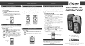
... 'YES.' Walk in the direction the arrow is now stored in memory) as destinations to navigate to highlight 'CLEAR.' To mark a waypoint: 1. Press and hold the ENTER button. If the arrow points to save your every move. To save in the eTrex's memory. 9 Pointer Page Basics Once you select a GOTO, the eTrex will guide you a time frame for a few trips, the map display can clean up . The TRACK LOG Page appears. 2. Press...
... 'YES.' Walk in the direction the arrow is now stored in memory) as destinations to navigate to highlight 'CLEAR.' To mark a waypoint: 1. Press and hold the ENTER button. If the arrow points to save your every move. To save in the eTrex's memory. 9 Pointer Page Basics Once you select a GOTO, the eTrex will guide you a time frame for a few trips, the map display can clean up . The TRACK LOG Page appears. 2. Press...


