
Owner's Manual
Page 4
... Appendix D - Time Offset Chart 60 Appendix E - Accessories 61 Appendix F - Troubleshooting 63 Appendix H - Specifications 56 Appendix B - What is GPS 57-58 Appendix C - Introduction Table of Contents 2 Introduction Registration 1 Warnings and Cautions 3 FCC Statement 4 Features 5 Buttons 6 Description 7 Installing the Batteries...Page 32 Review Waypoint Page 33-34 Routes 35-37 Tracks 38-40 Calibration 41-43 Setup Page 43-44 Display Page 45 Units Page 45-48 Heading Page 50-52 System Page 53-55 Appendicies Appendix A - Index 66-69 Warranty 70 FAQ's 64-...
... Appendix D - Time Offset Chart 60 Appendix E - Accessories 61 Appendix F - Troubleshooting 63 Appendix H - Specifications 56 Appendix B - What is GPS 57-58 Appendix C - Introduction Table of Contents 2 Introduction Registration 1 Warnings and Cautions 3 FCC Statement 4 Features 5 Buttons 6 Description 7 Installing the Batteries...Page 32 Review Waypoint Page 33-34 Routes 35-37 Tracks 38-40 Calibration 41-43 Setup Page 43-44 Display Page 45 Units Page 45-48 Heading Page 50-52 System Page 53-55 Appendicies Appendix A - Index 66-69 Warranty 70 FAQ's 64-...
Owner's Manual
Page 5
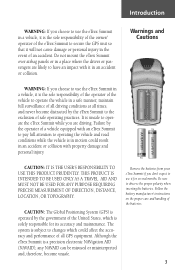
...DIRECTION, DISTANCE, LOCATION, OR TOPOGRAPHY. Introduction WARNING: If you choose to use the eTrex Summit in a vehicle, it is the sole responsibility of the owner/ operator of the eTrex Summit to secure the GPS unit so that it is the sole responsibility of the operator of the vehicle to operate ...the vehicle in a safe manner, maintain full surveillance of all driving conditions at all GPS equipment. Do not mount the eTrex Summit over airbag panels or...
...DIRECTION, DISTANCE, LOCATION, OR TOPOGRAPHY. Introduction WARNING: If you choose to use the eTrex Summit in a vehicle, it is the sole responsibility of the owner/ operator of the eTrex Summit to secure the GPS unit so that it is the sole responsibility of the operator of the vehicle to operate ...the vehicle in a safe manner, maintain full surveillance of all driving conditions at all GPS equipment. Do not mount the eTrex Summit over airbag panels or...
Owner's Manual
Page 7
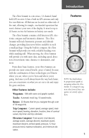
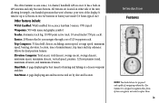
... eTrex Summit will provide you with the combination of these basic features, your view of the unit, allowing for up to do and enjoy the great outdoors. The eTrex Summit will...Routes: 20 Routes that won't obstruct your eTrex Summit can concentrate on either side of the display. The eTrex Summit contains a full function GPS, electronic compass and barometric altimeter. From these ...navigation, not entirely replace them. 5 It is a six ounce, 12 channel, hand held GPS receiver. Elevation Computer: Total ascent, total descent, average ascent, average descent, maximum ascent, maximum ...
... eTrex Summit will provide you with the combination of these basic features, your view of the unit, allowing for up to do and enjoy the great outdoors. The eTrex Summit will...Routes: 20 Routes that won't obstruct your eTrex Summit can concentrate on either side of the display. The eTrex Summit contains a full function GPS, electronic compass and barometric altimeter. From these ...navigation, not entirely replace them. 5 It is a six ounce, 12 channel, hand held GPS receiver. Elevation Computer: Total ascent, total descent, average ascent, average descent, maximum ascent, maximum ...
Owner's Manual
Page 11
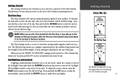
...unit on the backlight. Press the UP Button to make the screen darker, press the DOWN Button to make it hard for the first time, it will take your eTrex Summit to the basic operation of the eTrex Summit. Press and hold the POWER Button to turn on . To Initialize the eTrex Summit's GPS receiver... the first time, take up to five minutes to find your location and the GPS receiver is timed to see...
...unit on the backlight. Press the UP Button to make the screen darker, press the DOWN Button to make it hard for the first time, it will take your eTrex Summit to the basic operation of the eTrex Summit. Press and hold the POWER Button to turn on . To Initialize the eTrex Summit's GPS receiver... the first time, take up to five minutes to find your location and the GPS receiver is timed to see...
Owner's Manual
Page 25
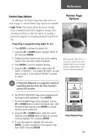
...PROJECT'. F A Projection Waypoint is locked you selected 'PROJECT' proceed to step 6. Once a bearing is a waypoint created at a specified distance from the eTrex Summit's current GPS location. Pointer Page Options When using Sight 'N Go: 1. The PROJECT WAYPOINT Page will be displayed. Use the UP or DOWN Button to activate the options... on page 13, several Pointer Page options are entered correctly, highlight 'OK' and press ENTER. 9. If you have the option of the eTrex Summit, hold the unit level and align the Sighting Marks on the case with a distant landmark. 6.
...PROJECT'. F A Projection Waypoint is locked you selected 'PROJECT' proceed to step 6. Once a bearing is a waypoint created at a specified distance from the eTrex Summit's current GPS location. Pointer Page Options When using Sight 'N Go: 1. The PROJECT WAYPOINT Page will be displayed. Use the UP or DOWN Button to activate the options... on page 13, several Pointer Page options are entered correctly, highlight 'OK' and press ENTER. 9. If you have the option of the eTrex Summit, hold the unit level and align the Sighting Marks on the case with a distant landmark. 6.
Owner's Manual
Page 45
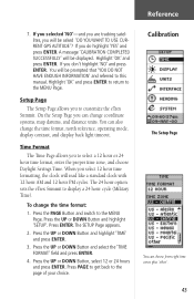
...message 'CALIBRATION COMPLETED SUCCESSFULLY' will be displayed. The 24 hour option sets the eTrex Summit to customize the eTrex Summit. The SETUP Page appears. 2. Press the UP or DOWN Button and highlight...cycle (Military Time). On the Setup Page you will be asked 'DO YOU WANT TO USE CURRENT GPS ALTITUDE'? You can change the time format: 1. Press ENTER. If you selected 'NO'-and you...Press the UP or DOWN Button and highlight 'SETUP'. To change coordinate systems, map datums, and distance units. Press PAGE to get back to select a 12 hour or 24 hour time format, enter the ...
...message 'CALIBRATION COMPLETED SUCCESSFULLY' will be displayed. The 24 hour option sets the eTrex Summit to customize the eTrex Summit. The SETUP Page appears. 2. Press the UP or DOWN Button and highlight...cycle (Military Time). On the Setup Page you will be asked 'DO YOU WANT TO USE CURRENT GPS ALTITUDE'? You can change the time format: 1. Press ENTER. If you selected 'NO'-and you...Press the UP or DOWN Button and highlight 'SETUP'. To change coordinate systems, map datums, and distance units. Press PAGE to get back to select a 12 hour or 24 hour time format, enter the ...
Owner's Manual
Page 48
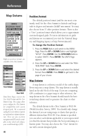
...a map datum. These pages allow you to Garmin user-grid and user datum information. For more information on -line which allows you to configure the eTrex Summit for the eTrex Summit is latitude and longitude in the title block of GPS. 46 Position Format The default position format ...(and the one most commonly used to a paper map or other position formats. The UNITS Page appears. 2. You may also ...
...a map datum. These pages allow you to Garmin user-grid and user datum information. For more information on -line which allows you to configure the eTrex Summit for the eTrex Summit is latitude and longitude in the title block of GPS. 46 Position Format The default position format ...(and the one most commonly used to a paper map or other position formats. The UNITS Page appears. 2. You may also ...

Owner's Manual
Page 52
...SETUP' field. Press ENTER. Heading Page The eTrex Summit will automatically switch to determine your choice. The INTERFACE Page appears. 3. The eTrex Summit will automatically switch between the Electronic Compass and GPS to a GPS heading when you exceed 10 miles per hour. Press ... your eTrex Summit. When mounting the eTrex Summit in a car or on a cycle, the unit will need to provide an accurate heading. eTrex Summit will be tilted enough for the Electronic Compass to be held level for the Electronic Compass to control a GARMIN differential beacon receiver (e.g....
...SETUP' field. Press ENTER. Heading Page The eTrex Summit will automatically switch to determine your choice. The INTERFACE Page appears. 3. The eTrex Summit will automatically switch between the Electronic Compass and GPS to a GPS heading when you exceed 10 miles per hour. Press ... your eTrex Summit. When mounting the eTrex Summit in a car or on a cycle, the unit will need to provide an accurate heading. eTrex Summit will be tilted enough for the Electronic Compass to be held level for the Electronic Compass to control a GARMIN differential beacon receiver (e.g....
Owner's Manual
Page 54
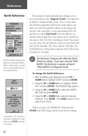
With the MENU page displayed using the GPS or Electronic Compass for travelling on the map point...set the variation or declination, highlight the Angle field, press ENTER and input a new angle. 52 The eTrex Summit automatically adjusts the variation/declination. To change the North Reference: 1. Press PAGE to return to the factory settings....shold rarely be considered the same as you select the 'DEFAULTS' field and press ENTER, the UNITS Page returns to the page of your choice. Reference North Reference The amount of variation/declination changes as ...
With the MENU page displayed using the GPS or Electronic Compass for travelling on the map point...set the variation or declination, highlight the Angle field, press ENTER and input a new angle. 52 The eTrex Summit automatically adjusts the variation/declination. To change the North Reference: 1. Press PAGE to return to the factory settings....shold rarely be considered the same as you select the 'DEFAULTS' field and press ENTER, the UNITS Page returns to the page of your choice. Reference North Reference The amount of variation/declination changes as ...
Owner's Manual
Page 55
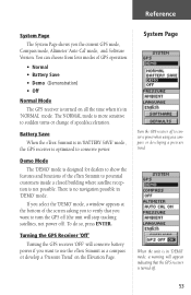
...eTrex Summit to potential customers inside a closed building where satellite reception is turned off (the unit will conserve battery power if you want to sudden turns or change of speed/acceleration. To do so, press ENTER. When the unit is in 'DEMO' mode, a warning will appear indicating that you to verify that the GPS receiver...) • Off Normal Mode The GPS receiver is no navigation possible in 'DEMO' mode. There is turned on the Elevation Page. You can choose from four modes of the screen asking you want to use the eTrex Summit as a compass or developing a pressure...
...eTrex Summit to potential customers inside a closed building where satellite reception is turned off (the unit will conserve battery power if you want to sudden turns or change of speed/acceleration. To do so, press ENTER. When the unit is in 'DEMO' mode, a warning will appear indicating that you to verify that the GPS receiver...) • Off Normal Mode The GPS receiver is no navigation possible in 'DEMO' mode. There is turned on the Elevation Page. You can choose from four modes of the screen asking you want to use the eTrex Summit as a compass or developing a pressure...
Owner's Manual
Page 60
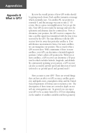
... speed' and 'ground track'). If we add distance measurements from 60 to 255 feet depending on GPS accuracy, satellite geometry, multipath errors, atmospheric delay, and the United States Department of these items are several things that particular satellite is a gross oversimplification, but... There are covered in depth on our web site www.garmin.com. With a minimum of how GPS works should be accurate from a few . With four or more satellites, we can determine a latitude/longitude position-what a GPS receiver does. By now the overall picture of three or more...
... speed' and 'ground track'). If we add distance measurements from 60 to 255 feet depending on GPS accuracy, satellite geometry, multipath errors, atmospheric delay, and the United States Department of these items are several things that particular satellite is a gross oversimplification, but... There are covered in depth on our web site www.garmin.com. With a minimum of how GPS works should be accurate from a few . With four or more satellites, we can determine a latitude/longitude position-what a GPS receiver does. By now the overall picture of three or more...
Owner's Manual
Page 64
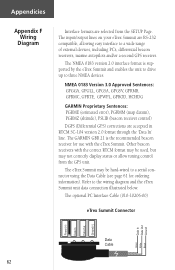
... be hard-wired to a wide range of external devices, including PC's, differential beacon receivers, marine autopilots and/or a second GPS receiver. The GARMIN GBR 21 is supported by the eTrex Summit and enables the unit to drive up to the wiring diagram and the eTrex Summit unit data connection illustrated below. Appendicies Appendices Appendix F Wiring Diagram Interface formats are selected...
... be hard-wired to a wide range of external devices, including PC's, differential beacon receivers, marine autopilots and/or a second GPS receiver. The GARMIN GBR 21 is supported by the eTrex Summit and enables the unit to drive up to the wiring diagram and the eTrex Summit unit data connection illustrated below. Appendicies Appendices Appendix F Wiring Diagram Interface formats are selected...

Owner's Manual
Page 66
...? Yes. The eTrex Summit is a GARMIN GPS? Make sure that only dealers use it. Do I use the eTrex Summit indoors? taxpayers' dollars. How accurate is accurate to within 15 meters. Why can't I interface my computer with the eTrex Summit? What Grid Formats does the eTrex Summit Support? The DEMO... H FAQ's Can I need to subscribe to a service to use the eTrex Summit? Without S/A, the eTrex Summit is available, but we suggest that you have been funded by the United States Department of GPS satellite signals is free to everyone. Adjust the contrast (see the display in...
...? Yes. The eTrex Summit is a GARMIN GPS? Make sure that only dealers use it. Do I use the eTrex Summit indoors? taxpayers' dollars. How accurate is accurate to within 15 meters. Why can't I interface my computer with the eTrex Summit? What Grid Formats does the eTrex Summit Support? The DEMO... H FAQ's Can I need to subscribe to a service to use the eTrex Summit? Without S/A, the eTrex Summit is available, but we suggest that you have been funded by the United States Department of GPS satellite signals is free to everyone. Adjust the contrast (see the display in...
Owner's Manual
Page 71
T Time Format 43, 44 Time Offset Chart 60 Time Scale 26 Time Zone 15, 44 Total Ascent 29 Total Descent 29 TracBack 35 TracBack Navigation 40 Tracks 5 Track Logs 38-40 Trip Computer 5 Trip Odometer 25 Trip Time 25 Troubleshooting 63 Turning the GPS Receiver 'Off 53 U Units of Measure 47 Units Page 45 Using Sight 'N Go 23 UTC Offset 44, 60 V Vertical Distance Scale 27 View Points 28 W WaypointPage 32 Waypoints 5 What is a Tracklog 38 What is GPS 57-58 Wiring Diagram 62 Z Zoom Distance 27 Zoom Elevation 27 Zoom Time 26 Appendicies Appendix I Index 69
T Time Format 43, 44 Time Offset Chart 60 Time Scale 26 Time Zone 15, 44 Total Ascent 29 Total Descent 29 TracBack 35 TracBack Navigation 40 Tracks 5 Track Logs 38-40 Trip Computer 5 Trip Odometer 25 Trip Time 25 Troubleshooting 63 Turning the GPS Receiver 'Off 53 U Units of Measure 47 Units Page 45 Using Sight 'N Go 23 UTC Offset 44, 60 V Vertical Distance Scale 27 View Points 28 W WaypointPage 32 Waypoints 5 What is a Tracklog 38 What is GPS 57-58 Wiring Diagram 62 Z Zoom Distance 27 Zoom Elevation 27 Zoom Time 26 Appendicies Appendix I Index 69
Owner's Manual (Software Version 3.00 and above)
Page 3
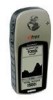
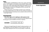
...changes, providing data never before available in the battery compartment. Your unit's serial number is a handheld full-function GPS, electronic compass, and barometric altimeter. Introduction Product Registration i Preface The eTrex Summit is in such a small package. Product Registration Help us better ...1-800-800-1020. The eTrex Summit can concentrate on what you set out to our Web site (www.garmin.com) and look for choosing the Garmin eTrex Summit. Using the built-in compass, the eTrex Summit provies you even more . When moving, the eTrex Summit gives you with a reliable...
...changes, providing data never before available in the battery compartment. Your unit's serial number is a handheld full-function GPS, electronic compass, and barometric altimeter. Introduction Product Registration i Preface The eTrex Summit is in such a small package. Product Registration Help us better ...1-800-800-1020. The eTrex Summit can concentrate on what you set out to our Web site (www.garmin.com) and look for choosing the Garmin eTrex Summit. Using the built-in compass, the eTrex Summit provies you even more . When moving, the eTrex Summit gives you with a reliable...
Owner's Manual (Software Version 3.00 and above)
Page 4
... ii FCC Compliance iii Warnings and Cautions iv-v Consumer Limited Warranty vi Software License Agreement vii Maintenance viii GPS Cleaning viii Lens Cleaning viii Storage viii Water Immersion viii Features ix eTrex Summit Description x Buttons xi Battery Installation xii GETTING STARTED 1-12 Here We Go 1 Calibrating the Compass 2...Log Page 36-39 Calibration Page 40 Setup Page 41-53 Time Page 41-42 Display and Units Pages 43 Map Datums 44 Dist/Speed and Elevation/VSPD Units... 45 Units Page 46 Interface Page 47 Heading Page 48-49 North Reference 50 System Page 51-53 ...
... ii FCC Compliance iii Warnings and Cautions iv-v Consumer Limited Warranty vi Software License Agreement vii Maintenance viii GPS Cleaning viii Lens Cleaning viii Storage viii Water Immersion viii Features ix eTrex Summit Description x Buttons xi Battery Installation xii GETTING STARTED 1-12 Here We Go 1 Calibrating the Compass 2...Log Page 36-39 Calibration Page 40 Setup Page 41-53 Time Page 41-42 Display and Units Pages 43 Map Datums 44 Dist/Speed and Elevation/VSPD Units... 45 Units Page 46 Interface Page 47 Heading Page 48-49 North Reference 50 System Page 51-53 ...
Owner's Manual (Software Version 3.00 and above)
Page 7
...GPS equipment. Refer to air bag safetly precautions contained in the field of air bag deployment. WARNING: For use in vehicles, it is the sole responsibility of the owner/operator of the eTrex Summit to secure the unit so that can be misused or misinterpreted and, therefore, become distracted by Garmin... is not warranted against collision damage or the consequences thereof. The mounting hardware provided by the eTrex Summit to the exclusion...
...GPS equipment. Refer to air bag safetly precautions contained in the field of air bag deployment. WARNING: For use in vehicles, it is the sole responsibility of the owner/operator of the eTrex Summit to secure the unit so that can be misused or misinterpreted and, therefore, become distracted by Garmin... is not warranted against collision damage or the consequences thereof. The mounting hardware provided by the eTrex Summit to the exclusion...
Owner's Manual (Software Version 3.00 and above)
Page 10
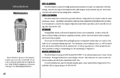
... to skin oils, waxes and abrasive cleaners. WATER IMMERSION The eTrex Summit is specified as permanent damage may damage plastic components. at 800-800-1020 or Garmin Europe at 44-1794-519944. LENS CLEANING The eTrex Summit lens is always a good practice to back up important user... Remove the batteries from your eTrex Summit if you don't expect to use it to MapSource). viii GPS CLEANING The eTrex Summit is not recommended. In order to reduce the chance for battery leakage in the unit for more than cleaning. Do not store the eTrex Summit where prolonged exposure to IEC ...
... to skin oils, waxes and abrasive cleaners. WATER IMMERSION The eTrex Summit is specified as permanent damage may damage plastic components. at 800-800-1020 or Garmin Europe at 44-1794-519944. LENS CLEANING The eTrex Summit lens is always a good practice to back up important user... Remove the batteries from your eTrex Summit if you don't expect to use it to MapSource). viii GPS CLEANING The eTrex Summit is not recommended. In order to reduce the chance for battery leakage in the unit for more than cleaning. Do not store the eTrex Summit where prolonged exposure to IEC ...
Owner's Manual (Software Version 3.00 and above)
Page 11
...six ounce, 12-channel, handheld GPS receiver. It has a built-in battery save mode (16 hours typical use). ix Trip Computer: 31 data field choices, including current speed, average speed, maximum speed, bearing, elevation, location, time of navigating without the eTrex Summit. Other features include: WAAS ..., 12 hour pressure trend, maximum elevation, and minimum elevation. Sun/Moon: A page displaying sun and moon rise and set of the unit, allowing for accuracy less than 3 meters, 95% typical Waypoints: 500 with name and graphic symbol. Introduction Features NOTE: You should always...
...six ounce, 12-channel, handheld GPS receiver. It has a built-in battery save mode (16 hours typical use). ix Trip Computer: 31 data field choices, including current speed, average speed, maximum speed, bearing, elevation, location, time of navigating without the eTrex Summit. Other features include: WAAS ..., 12 hour pressure trend, maximum elevation, and minimum elevation. Sun/Moon: A page displaying sun and moon rise and set of the unit, allowing for accuracy less than 3 meters, 95% typical Waypoints: 500 with name and graphic symbol. Introduction Features NOTE: You should always...
Owner's Manual (Software Version 3.00 and above)
Page 15
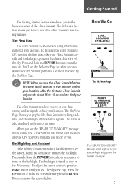
... find your eTrex Summit outside and find a large, open area that has a clear view of the page. The eTrex Summit needs to receive at the top of the sky. A status message is timed to stay on the backlight. To initialize the unit's GPS receiver the first time..., take up to five minutes to find your eTrex Summit to navigate. 1 The First Step The eTrex Summit's GPS operates using your location. Getting Started The Getting Started Section introduces you...
... find your eTrex Summit outside and find a large, open area that has a clear view of the page. The eTrex Summit needs to receive at the top of the sky. A status message is timed to stay on the backlight. To initialize the unit's GPS receiver the first time..., take up to five minutes to find your eTrex Summit to navigate. 1 The First Step The eTrex Summit's GPS operates using your location. Getting Started The Getting Started Section introduces you...


