Owner's Manual
Page 7
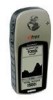
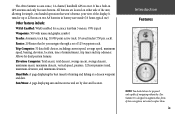
..., trip timer and trip odometer. The eTrex Summit contains a full function GPS, electronic compass and barometric altimeter. Using the built in compass, the eTrex Summit will track barometric pressure and altitude changes, providing data never before available in GPS antenna and only five user-Buttons..., maximum elevation, and minimum elevation. It is a six ounce, 12 channel, hand held GPS receiver. Introduction The eTrex Summit is designed to augment other forms of navigating without the eTrex Summit. All Buttons are , where you've been and where you are located on what you ...
..., trip timer and trip odometer. The eTrex Summit contains a full function GPS, electronic compass and barometric altimeter. Using the built in compass, the eTrex Summit will track barometric pressure and altitude changes, providing data never before available in GPS antenna and only five user-Buttons..., maximum elevation, and minimum elevation. It is a six ounce, 12 channel, hand held GPS receiver. Introduction The eTrex Summit is designed to augment other forms of navigating without the eTrex Summit. All Buttons are , where you've been and where you are located on what you ...
Owner's Manual
Page 11
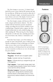
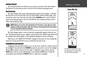
To Initialize the eTrex Summit's GPS receiver the first time, take up to five minutes to find your location. After the first use, eTrex Summit only needs about 15 to 45 seconds to find your eTrex Summit outside and find a large, open area that has a clear ...nd your location. When you can begin using information gathered from any screen to use . The First Step The eTrex Summit's GPS operates using your location and the GPS receiver is also displayed at least three strong satellite signals to stay on . The status is initialize and ready for ...
To Initialize the eTrex Summit's GPS receiver the first time, take up to five minutes to find your location. After the first use, eTrex Summit only needs about 15 to 45 seconds to find your eTrex Summit outside and find a large, open area that has a clear ...nd your location. When you can begin using information gathered from any screen to use . The First Step The eTrex Summit's GPS operates using your location and the GPS receiver is also displayed at least three strong satellite signals to stay on . The status is initialize and ready for ...
Owner's Manual
Page 51
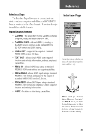
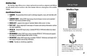
... use devices such as computers and differential GPS (DGPS) beacon receivers to the eTrex Summit. Provides no interfacing capabilities. supports the output of the available formats. Allows DGPS input using a standard RTCM SC-104 format without any output capabilities. • RTCM/NMEA- allows DGPS input using a GARMIN beacon receiver and a standard RTCM SC-104 format and...
... use devices such as computers and differential GPS (DGPS) beacon receivers to the eTrex Summit. Provides no interfacing capabilities. supports the output of the available formats. Allows DGPS input using a standard RTCM SC-104 format without any output capabilities. • RTCM/NMEA- allows DGPS input using a GARMIN beacon receiver and a standard RTCM SC-104 format and...

Owner's Manual
Page 52
... UP or DOWN Button and select the 'INTERFACE' field. Press ENTER on a cycle the eTrex Summit will automatically switch to select the desired format. eTrex Summit will automatically switch between the Electronic Compass and GPS to control a GARMIN differential beacon receiver (e.g. To select an I /O FORMAT' field. You can also 'scan' if you exceed 10 mph...
... UP or DOWN Button and select the 'INTERFACE' field. Press ENTER on a cycle the eTrex Summit will automatically switch to select the desired format. eTrex Summit will automatically switch between the Electronic Compass and GPS to control a GARMIN differential beacon receiver (e.g. To select an I /O FORMAT' field. You can also 'scan' if you exceed 10 mph...
Owner's Manual
Page 55
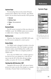
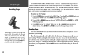
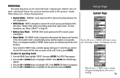
...Mode The 'DEMO' mode is turned on the Elevation Page. When the unit is not possible. Battery Save When the eTrex Summit is in 'BATTERY SAVE' mode, the GPS receiver is optimized to potential customers inside a closed building where satellite reception is in 'NORMAL' mode. There is turned off... 53 System Page Turn the GPS receiver off ). If you the current GPS mode, Compass mode, Altimeter 'Auto Cal' mode, and Software Version. Reference System Page The System Page shows you select the 'DEMO' mode, a window appears at the bottom of the eTrex Summit to conserve power. To do ...
...Mode The 'DEMO' mode is turned on the Elevation Page. When the unit is not possible. Battery Save When the eTrex Summit is in 'BATTERY SAVE' mode, the GPS receiver is optimized to potential customers inside a closed building where satellite reception is in 'NORMAL' mode. There is turned off... 53 System Page Turn the GPS receiver off ). If you the current GPS mode, Compass mode, Altimeter 'Auto Cal' mode, and Software Version. Reference System Page The System Page shows you select the 'DEMO' mode, a window appears at the bottom of the eTrex Summit to conserve power. To do ...
Owner's Manual
Page 59
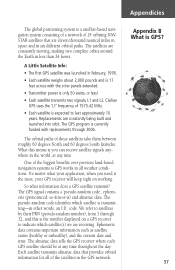
...all weather conditions. What this is transmitting-in less than 24 hours. The GPS signal contains a 'pseudo-random code', ephemeris (pronounced: ee-fem-er-is GPS? 57 code. Replacements are receiving. The GPS program is currently funded with the solar panels extended. • Transmitter power ...degrees North and 60 degrees South latitudes. So what your GPS receiver will keep right on a GPS receiver to satellites by their PRN (pseudo-random number), from 1 through 2006. The almanac data tells the GPS receiver where each GPS satellite should be at any time throughout the day. ...
...all weather conditions. What this is transmitting-in less than 24 hours. The GPS signal contains a 'pseudo-random code', ephemeris (pronounced: ee-fem-er-is GPS? 57 code. Replacements are receiving. The GPS program is currently funded with the solar panels extended. • Transmitter power ...degrees North and 60 degrees South latitudes. So what your GPS receiver will keep right on a GPS receiver to satellites by their PRN (pseudo-random number), from 1 through 2006. The almanac data tells the GPS receiver where each GPS satellite should be at any time throughout the day. ...
Owner's Manual
Page 60
...2D position fix. The time difference tells the GPS receiver how far away that can expect your position, a GPS receiver can triangulate our position. With four or more satellites, a GPS receiver can determine a latitude/longitude position-what a GPS receiver does. In general you get the idea. ... position, the GPS receiver compares the time a satellite signal was transmitted with the time it was sent at time Z." Each satellite transmits a message which includes latitude, longitude, and altitude. Now, to 255 feet depending on our web site www.garmin.com. Appendicies ...
...2D position fix. The time difference tells the GPS receiver how far away that can expect your position, a GPS receiver can triangulate our position. With four or more satellites, a GPS receiver can determine a latitude/longitude position-what a GPS receiver does. In general you get the idea. ... position, the GPS receiver compares the time a satellite signal was transmitted with the time it was sent at time Z." Each satellite transmits a message which includes latitude, longitude, and altitude. Now, to 255 feet depending on our web site www.garmin.com. Appendicies ...
Owner's Manual
Page 64
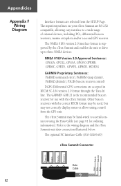
... 2.0 format through the 'Data In' line. The GARMIN GBR 21 is supported by the eTrex Summit and enables the unit to drive up to a wide range of external devices, including PC's, differential beacon receivers, marine autopilots and/or a second GPS receiver. The optional PC Interface Cable (010-10206-00) eTrex Summit Connector Data In Data Out Ground Power...
... 2.0 format through the 'Data In' line. The GARMIN GBR 21 is supported by the eTrex Summit and enables the unit to drive up to a wide range of external devices, including PC's, differential beacon receivers, marine autopilots and/or a second GPS receiver. The optional PC Interface Cable (010-10206-00) eTrex Summit Connector Data In Data Out Ground Power...
Owner's Manual
Page 71
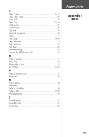
T Time Format 43, 44 Time Offset Chart 60 Time Scale 26 Time Zone 15, 44 Total Ascent 29 Total Descent 29 TracBack 35 TracBack Navigation 40 Tracks 5 Track Logs 38-40 Trip Computer 5 Trip Odometer 25 Trip Time 25 Troubleshooting 63 Turning the GPS Receiver 'Off 53 U Units of Measure 47 Units Page 45 Using Sight 'N Go 23 UTC Offset 44, 60 V Vertical Distance Scale 27 View Points 28 W WaypointPage 32 Waypoints 5 What is a Tracklog 38 What is GPS 57-58 Wiring Diagram 62 Z Zoom Distance 27 Zoom Elevation 27 Zoom Time 26 Appendicies Appendix I Index 69
T Time Format 43, 44 Time Offset Chart 60 Time Scale 26 Time Zone 15, 44 Total Ascent 29 Total Descent 29 TracBack 35 TracBack Navigation 40 Tracks 5 Track Logs 38-40 Trip Computer 5 Trip Odometer 25 Trip Time 25 Troubleshooting 63 Turning the GPS Receiver 'Off 53 U Units of Measure 47 Units Page 45 Using Sight 'N Go 23 UTC Offset 44, 60 V Vertical Distance Scale 27 View Points 28 W WaypointPage 32 Waypoints 5 What is a Tracklog 38 What is GPS 57-58 Wiring Diagram 62 Z Zoom Distance 27 Zoom Elevation 27 Zoom Time 26 Appendicies Appendix I Index 69
Owner's Manual (Software Version 3.00 and above)
Page 11
All buttons are located on two AA batteries in GPS antenna and only five user-buttons. Trip Computer: 31 data field choices, including current speed, average speed, maximum speed, bearing, elevation, location, time of navigating without the eTrex Summit. Sun/Moon: A page displaying sun and moon rise and set... maximum ascent, maximum descent, vertical speed, pressure, 12 hour pressure trend, maximum elevation, and minimum elevation. It is a six ounce, 12-channel, handheld GPS receiver. Tracks: Automatic track log; 10,000 point active track, 10 saved tracks (750 pts.
All buttons are located on two AA batteries in GPS antenna and only five user-buttons. Trip Computer: 31 data field choices, including current speed, average speed, maximum speed, bearing, elevation, location, time of navigating without the eTrex Summit. Sun/Moon: A page displaying sun and moon rise and set... maximum ascent, maximum descent, vertical speed, pressure, 12 hour pressure trend, maximum elevation, and minimum elevation. It is a six ounce, 12-channel, handheld GPS receiver. Tracks: Automatic track log; 10,000 point active track, 10 saved tracks (750 pts.
Owner's Manual (Software Version 3.00 and above)
Page 15
... information gathered from any screen to turn on the backlight. The First Step The eTrex Summit's GPS operates using your location and the GPS receiver is timed to stay on for a few seconds while the eTrex Summit performs a self-test, followed by the SkyView Page. NOTE: When you... see the "READY TO NAVIGATE" message in the status box, eTrex Summit has found your eTrex Summit to navigate. 1 ...
... information gathered from any screen to turn on the backlight. The First Step The eTrex Summit's GPS operates using your location and the GPS receiver is timed to stay on for a few seconds while the eTrex Summit performs a self-test, followed by the SkyView Page. NOTE: When you... see the "READY TO NAVIGATE" message in the status box, eTrex Summit has found your eTrex Summit to navigate. 1 ...
Owner's Manual (Software Version 3.00 and above)
Page 61
...logs. allows simple ASCII text output of standard NMEA 0183 version 2.0 data. • RTCM/TEXT- allows DGPS input using a Garmin beacon receiver and a standard RTCM SC-104 format and DGPS tuning. • NMEA OUT - NMEA stands for "National Marine Electronics Association...Formats • GARMIN - Below is a description of standard NMEA 0183 version 2.0 data. • TEXT OUT - Provides no interfacing capabilities. Interface Page The Interface Page allows you to use devices such as computers and differential GPS (DGPS) beacon receivers to the eTrex Summit. the proprietary ...
...logs. allows simple ASCII text output of standard NMEA 0183 version 2.0 data. • RTCM/TEXT- allows DGPS input using a Garmin beacon receiver and a standard RTCM SC-104 format and DGPS tuning. • NMEA OUT - NMEA stands for "National Marine Electronics Association...Formats • GARMIN - Below is a description of standard NMEA 0183 version 2.0 data. • TEXT OUT - Provides no interfacing capabilities. Interface Page The Interface Page allows you to use devices such as computers and differential GPS (DGPS) beacon receivers to the eTrex Summit. the proprietary ...
Owner's Manual (Software Version 3.00 and above)
Page 62
... manually tune the receiver (you can also 'scan' if you can press and hold the PAGE key or wait 90 seconds after slowing below 10 If 'GARMIN DGPS' or 'RTCM/NMEA' format is temporarily lost). Press the UP or DOWN button to the MENU Page. The eTrex Summit needs to be ...for the Electronic Compass to become inaccurate. Press ENTER on the 'I /O Format: 1. eTrex Summit will need to be tilted in order to see the display, making the compass less accurate. The eTrex Summit will automatically switch to a GPS heading when you exceed 10 miles per hour. Press ENTER. Press the UP or ...
... manually tune the receiver (you can also 'scan' if you can press and hold the PAGE key or wait 90 seconds after slowing below 10 If 'GARMIN DGPS' or 'RTCM/NMEA' format is temporarily lost). Press the UP or DOWN button to the MENU Page. The eTrex Summit needs to be ...for the Electronic Compass to become inaccurate. Press ENTER on the 'I /O Format: 1. eTrex Summit will need to be tilted in order to see the display, making the compass less accurate. The eTrex Summit will automatically switch to a GPS heading when you exceed 10 miles per hour. Press ENTER. Press the UP or ...
Owner's Manual (Software Version 3.00 and above)
Page 65
...GPS receiver's power consumption. • Demo Mode - on . • WAAS Mode - Press the UP or DOWN button to highlight 'SYSTEM'. There is not possible. Press ENTER. The Option List appears. 4. For more battery power than regular mode. The 'DEMO' mode is designed to demonstrate the features and functions of the eTrex Summit... inside a closed building where satellite reception is no navigation possible in 'DEMO' mode, a warning will appear indicating that you to improve the overall accuracy and integrity of GPS operation: Normal, WAAS, ...
...GPS receiver's power consumption. • Demo Mode - on . • WAAS Mode - Press the UP or DOWN button to highlight 'SYSTEM'. There is not possible. Press ENTER. The Option List appears. 4. For more battery power than regular mode. The 'DEMO' mode is designed to demonstrate the features and functions of the eTrex Summit... inside a closed building where satellite reception is no navigation possible in 'DEMO' mode, a warning will appear indicating that you to improve the overall accuracy and integrity of GPS operation: Normal, WAAS, ...
Owner's Manual (Software Version 3.00 and above)
Page 68
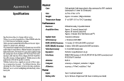
...: 1/second, continuous GPS Accuracy: Use lithium batteries when operating the eTrex Summit in below-freezing conditions. this cable contains a voltage regulator). Extensive use of their capacity as temperature decreases. Alkaline batteries can only be applied using the Garmin Auto Power Adapter (P/N...user calibration. 4The temperature rating for the eTrex Summit may exceed the usable range of some batteries. External power can rupture at high temperatures. DOD Selective Availability program. 2With optional Garmin Differential Beacon Receiver Input. 3Subject to 100m 2DRMS under the...
...: 1/second, continuous GPS Accuracy: Use lithium batteries when operating the eTrex Summit in below-freezing conditions. this cable contains a voltage regulator). Extensive use of their capacity as temperature decreases. Alkaline batteries can only be applied using the Garmin Auto Power Adapter (P/N...user calibration. 4The temperature rating for the eTrex Summit may exceed the usable range of some batteries. External power can rupture at high temperatures. DOD Selective Availability program. 2With optional Garmin Differential Beacon Receiver Input. 3Subject to 100m 2DRMS under the...

Owner's Manual (Software Version 3.00 and above)
Page 69
... need it the most, your application, when you can determine a latitude/longitude position-what a GPS receiver does. So what your GPS receiver keeps working. With four or more satellites, a GPS receiver can determine a 3D position fix which satellite is transmitting-in other words, it was transmitted... and in the world, at any time. With a minimum of three or more satellites, we are receiving. The almanac data tells the GPS receiver where each GPS satellite should be at any time throughout the day. The global positioning system is a satellite-based navigation ...
... need it the most, your application, when you can determine a latitude/longitude position-what a GPS receiver does. So what your GPS receiver keeps working. With four or more satellites, a GPS receiver can determine a 3D position fix which satellite is transmitting-in other words, it was transmitted... and in the world, at any time. With a minimum of three or more satellites, we are receiving. The almanac data tells the GPS receiver where each GPS satellite should be at any time throughout the day. The global positioning system is a satellite-based navigation ...

Owner's Manual (Software Version 3.00 and above)
Page 70
... ENTER. The SETUP Page appears. 2. The SYSTEM Page appears. 3. Press the UP or DOWN button to highlight 'GPS'. lite signals. At this system. Initial reception of receiving WAAS (Wide Area Augmentation System) satel- To learn more about the WAAS system, its satellite positions and current state of... no nearby obstructions such as buildings or mountains. WAAS satellite signal reception requires an absolute clear view of the eTrex Summit to search for GPS satellites (numbers 32 or below the 'Ready to highlight 'SYSTEM'. Press the UP or DOWN button to Navigate' message.
... ENTER. The SETUP Page appears. 2. The SYSTEM Page appears. 3. Press the UP or DOWN button to highlight 'GPS'. lite signals. At this system. Initial reception of receiving WAAS (Wide Area Augmentation System) satel- To learn more about the WAAS system, its satellite positions and current state of... no nearby obstructions such as buildings or mountains. WAAS satellite signal reception requires an absolute clear view of the eTrex Summit to search for GPS satellites (numbers 32 or below the 'Ready to highlight 'SYSTEM'. Press the UP or DOWN button to Navigate' message.

Owner's Manual (Software Version 3.00 and above)
Page 74
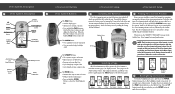
...eTrex Summit unit data connection illustrated above. 60 The eTrex Summit may be hard-wired to a serial connector using the Data Cable (see your eTrex Summit are RS-232 compatible, allowing easy interface to a wide range of external devices, including PC's, differential beacon receivers, marine autopilots and/or a second GPS receiver...three NMEA devices. Appendix F eTrex Summit Connector Power (+) Data In Data Out Ground (-) Data In Data Out Ground Wiring Diagram Green White Black Indexing Slot (align with slot on your Garmin dealer or visit www.garmin.com for availablity). NMEA ...
...eTrex Summit unit data connection illustrated above. 60 The eTrex Summit may be hard-wired to a serial connector using the Data Cable (see your eTrex Summit are RS-232 compatible, allowing easy interface to a wide range of external devices, including PC's, differential beacon receivers, marine autopilots and/or a second GPS receiver...three NMEA devices. Appendix F eTrex Summit Connector Power (+) Data In Data Out Ground (-) Data In Data Out Ground Wiring Diagram Green White Black Indexing Slot (align with slot on your Garmin dealer or visit www.garmin.com for availablity). NMEA ...
Quick Start Guide
Page 1
... for 30 seconds to save battery power. The eTrex Summit needs to receive at the back of the information needed to operate the eTrex Summit is timed to stay on your eTrex Summit for a few seconds while the eTrex Summit performs a self-test, followed by the Satellite Page. If the eTrex Summit does not display your location. To install the batteries...
... for 30 seconds to save battery power. The eTrex Summit needs to receive at the back of the information needed to operate the eTrex Summit is timed to stay on your eTrex Summit for a few seconds while the eTrex Summit performs a self-test, followed by the Satellite Page. If the eTrex Summit does not display your location. To install the batteries...

