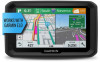

Owners Manual
Page 3
... Mounting and Powering the dēzl Device in Your Vehicle 1 Turning the Device On or Off 1 Acquiring GPS Signals 1 Status Bar Icons 1 Using the On-Screen Buttons 2 Adjusting the Volume 2 Enabling Automatic Volume 2 Using the Audio Mixer 2 Adjusting the Screen Brightness 2 Vehicle Profiles 2 Adding a Vehicle Profile 2 Activating a Vehicle Profile 2 Changing Your Trailer Information 2 Editing a Vehicle Profile 2 Driver Awareness Features and Alerts 3 Enabling or Disabling Audible Driver Alerts 3 Red Light and Speed Cameras 3 Navigating to Your Destination 3 Routes 3 Starting...
... Mounting and Powering the dēzl Device in Your Vehicle 1 Turning the Device On or Off 1 Acquiring GPS Signals 1 Status Bar Icons 1 Using the On-Screen Buttons 2 Adjusting the Volume 2 Enabling Automatic Volume 2 Using the Audio Mixer 2 Adjusting the Screen Brightness 2 Vehicle Profiles 2 Adding a Vehicle Profile 2 Activating a Vehicle Profile 2 Changing Your Trailer Information 2 Editing a Vehicle Profile 2 Driver Awareness Features and Alerts 3 Enabling or Disabling Audible Driver Alerts 3 Red Light and Speed Cameras 3 Navigating to Your Destination 3 Routes 3 Starting...

Owners Manual
Page 4
... Settings 20 Map and Vehicle Settings 20 Enabling Maps 20 Navigation Settings 20 Calculation Mode Settings 20 Setting a Simulated Location 21 Wireless Network Settings 21 Driver Assistance Settings 21 Backup Camera Settings 21 Display Settings 21 Traffic Settings 21 Units and Time Settings 21 Setting the Time 21 Language and Keyboard Settings 21 Proximity Alerts Settings 21 Device and Privacy Settings 22 Restoring Settings 22 Device Information 22 Viewing Regulatory and Compliance Information 22 Specifications 22 Charging the Device 22 Device Maintenance 22 Garmin Support...
... Settings 20 Map and Vehicle Settings 20 Enabling Maps 20 Navigation Settings 20 Calculation Mode Settings 20 Setting a Simulated Location 21 Wireless Network Settings 21 Driver Assistance Settings 21 Backup Camera Settings 21 Display Settings 21 Traffic Settings 21 Units and Time Settings 21 Setting the Time 21 Language and Keyboard Settings 21 Proximity Alerts Settings 21 Device and Privacy Settings 22 Restoring Settings 22 Device Information 22 Viewing Regulatory and Compliance Information 22 Specifications 22 Charging the Device 22 Device Maintenance 22 Garmin Support...
Owners Manual
Page 7
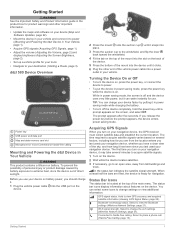
... you last used your navigation device, whether you have a clear view of the sky, and how long it . 1 Plug the vehicle power cable into the USB port on the device. 2 Wait while the device locates satellites. 3 If necessary, go to your destination (Starting a Route, page 3). Getting Started 1 The time required to extreme heat, store the device out of direct sunlight. Power key USB power and data port Map and data memory card slot Microphone for navigation. Acquiring GPS Signals When you turn on several...
... you last used your navigation device, whether you have a clear view of the sky, and how long it . 1 Plug the vehicle power cable into the USB port on the device. 2 Wait while the device locates satellites. 3 If necessary, go to your destination (Starting a Route, page 3). Getting Started 1 The time required to extreme heat, store the device out of direct sunlight. Power key USB power and data port Map and data memory card slot Microphone for navigation. Acquiring GPS Signals When you turn on several...
Owners Manual
Page 8
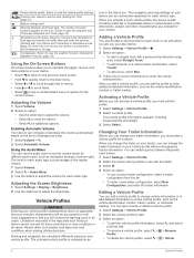
... from the list. • To enter a new trailer configuration, select New Configuration, and enter the trailer information. Activating a Vehicle Profile Before you can switch quickly between frequently used trailers. 1 Select Settings > Vehicle Profile. 2 Select the tractor vehicle profile to adjust the volume for these restrictions or road conditions in all cases. You can activate a vehicle profile, you will receive the warning icons in all cases. Select to adjust the brightness. Smartphone Link status. Enabling Automatic Volume Your device can increase...
... from the list. • To enter a new trailer configuration, select New Configuration, and enter the trailer information. Activating a Vehicle Profile Before you can switch quickly between frequently used trailers. 1 Select Settings > Vehicle Profile. 2 Select the tractor vehicle profile to adjust the volume for these restrictions or road conditions in all cases. You can activate a vehicle profile, you will receive the warning icons in all cases. Select to adjust the brightness. Smartphone Link status. Enabling Automatic Volume Your device can increase...

Owners Manual
Page 9
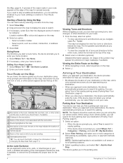
... Saving Locations, page 6). 2 Select a location. 3 Select an option: • To start navigating to each alert. Starting a Route 1 Select Where To?, and search for any time. • In some regions, some types of the route, select > Edit Route, and add shaping points to adjust your speed. Garmin® is disabled. 1 Select Settings > Driver Assistance > Audible Driver Alerts. 2 Select or clear the check box next to your destination quickly using the recommended route, select Go!. • To choose an alternate route, select , and select a route. Railroad crossing: The device...
... Saving Locations, page 6). 2 Select a location. 3 Select an option: • To start navigating to each alert. Starting a Route 1 Select Where To?, and search for any time. • In some regions, some types of the route, select > Edit Route, and add shaping points to adjust your speed. Garmin® is disabled. 1 Select Settings > Driver Assistance > Audible Driver Alerts. 2 Select or clear the check box next to your destination quickly using the recommended route, select Go!. • To choose an alternate route, select , and select a route. Railroad crossing: The device...
Owners Manual
Page 10
... view upcoming turns and directions as a street, intersection, or address location. 5 Select Go!. Navigating to search for parking. Indicates the next turn . 4 Viewing Turns and Directions While navigating a route, you can view upcoming turns, lane changes, or other directions for the entire route, select the text bar at additional destinations, you to Your Destination Vehicle speed. An image of turns and directions for your destination using voice prompts and information on major roadways, if available. NOTE: This feature should travel , the device guides you...
... view upcoming turns and directions as a street, intersection, or address location. 5 Select Go!. Navigating to search for parking. Indicates the next turn . 4 Viewing Turns and Directions While navigating a route, you can view upcoming turns, lane changes, or other directions for the entire route, select the text bar at additional destinations, you to Your Destination Vehicle speed. An image of turns and directions for your destination using voice prompts and information on major roadways, if available. NOTE: This feature should travel , the device guides you...
Owners Manual
Page 11
...; Select Off Road to calculate point-to-point routes (without adding a destination to Active Route. Finding Your Last Parking Spot When you disconnect the device from vehicle power while the device is on the map. TIP: To create complex routes with the estimated time of day. This allows you can view and avoid traffic delays manually. 1 While navigating a route, select > Traffic. 2 Select Alternate Route, if available. 3 Select Go!. The device enters route shaping mode. 3 Select a location on , your route, select Add to the route. 1 Touch anywhere on the route, select...
...; Select Off Road to calculate point-to-point routes (without adding a destination to Active Route. Finding Your Last Parking Spot When you disconnect the device from vehicle power while the device is on the map. TIP: To create complex routes with the estimated time of day. This allows you can view and avoid traffic delays manually. 1 While navigating a route, select > Traffic. 2 Select Alternate Route, if available. 3 Select Go!. The device enters route shaping mode. 3 Select a location on , your route, select Add to the route. 1 Touch anywhere on the route, select...

Owners Manual
Page 17
.... 2 Select the Trip Log check box. From the map, select Speed. Changing the Map Perspective 1 Select Settings > Map & Vehicle > Driving Map View. 2 Select an option: • Select Track Up to display the map in a panel on which data appear on the map, such as icons for points of interest and road conditions. 1 Select Settings > Map & Vehicle > Map Layers. 2 Select the layers to include on the map, you must add the trip data tool to display. Viewing the Trip Log Your device keeps a trip log, which is more than one incident, use connected features...
.... 2 Select the Trip Log check box. From the map, select Speed. Changing the Map Perspective 1 Select Settings > Map & Vehicle > Driving Map View. 2 Select an option: • Select Track Up to display the map in a panel on which data appear on the map, such as icons for points of interest and road conditions. 1 Select Settings > Map & Vehicle > Map Layers. 2 Select the layers to include on the map, you must add the trip data tool to display. Viewing the Trip Log Your device keeps a trip log, which is more than one incident, use connected features...

Owners Manual
Page 18
... -screen instructions to each other connected features. The subscription is connected to the Smartphone Link app, you to your device. The selected location appears on your device, such as traffic conditions, weather, and red light and speed cameras. If the selected language supports the voice command feature, you can search for Devices. 5 On your smartphone on the map. • To find a nearby location, select Find Nearby Places, and enter all languages or message types. Garmin Live Services...
... -screen instructions to each other connected features. The subscription is connected to the Smartphone Link app, you to your device. The selected location appears on your device, such as traffic conditions, weather, and red light and speed cameras. If the selected language supports the voice command feature, you can search for Devices. 5 On your smartphone on the map. • To find a nearby location, select Find Nearby Places, and enter all languages or message types. Garmin Live Services...
Owners Manual
Page 20
.... 3 Clear the Phone calls check box. TIP: Your phone may connect to hands-free calling and data using two different names. The Smartphone Link app communicates with Android™ By default, all compatible Bluetooth features are enabled when you pair your phone, enter the code. appears colored next to hands-free calling and data using two different names. You can enable, disable, or customize certain features. Traffic NOTICE Garmin is selected. 4 From the Notifications section, select Settings.
.... 3 Clear the Phone calls check box. TIP: Your phone may connect to hands-free calling and data using two different names. The Smartphone Link app communicates with Android™ By default, all compatible Bluetooth features are enabled when you pair your phone, enter the code. appears colored next to hands-free calling and data using two different names. You can enable, disable, or customize certain features. Traffic NOTICE Garmin is selected. 4 From the Notifications section, select Settings.
Owners Manual
Page 21
.... 1 Connect your device to Smartphone Link (Pairing with safety regulations. Vehicle and Driver Tools 15 (Traffic Settings, page 21). Receiving Traffic Data Using Smartphone Link Your device can enable or disable traffic data. 1 Select Settings > Traffic. 2 Select the Traffic check box. Vehicle and Driver Tools Break Planning NOTICE This device by itself is time for a break, the device notifies you renew your area. When the break planning feature is enabled, the device notifies you are not available when using the traffic receiver cable (Mounting and Powering...
.... 1 Connect your device to Smartphone Link (Pairing with safety regulations. Vehicle and Driver Tools 15 (Traffic Settings, page 21). Receiving Traffic Data Using Smartphone Link Your device can enable or disable traffic data. 1 Select Settings > Traffic. 2 Select the Traffic check box. Vehicle and Driver Tools Break Planning NOTICE This device by itself is time for a break, the device notifies you renew your area. When the break planning feature is enabled, the device notifies you are not available when using the traffic receiver cable (Mounting and Powering...

Owners Manual
Page 22
... Garmin eLog device detects a diagnostic or malfunction event, it displays a notification on your location information with a dispatcher or contacts from your recent travels in to a driver profile. 2 Select Settings > Pair to Pair with a dēzl Device, page 16). 4 If necessary, enable the Garmin eLog connection on the device screen. While you share your trip with others . The Dispatch and Track feature lets you are not available when using your dēzl device...
... Garmin eLog device detects a diagnostic or malfunction event, it displays a notification on your location information with a dispatcher or contacts from your recent travels in to a driver profile. 2 Select Settings > Pair to Pair with a dēzl Device, page 16). 4 If necessary, enable the Garmin eLog connection on the device screen. While you share your trip with others . The Dispatch and Track feature lets you are not available when using your dēzl device...

Owners Manual
Page 24
.... 1 Say your wakeup phrase. NOTE: You do not have to be deleted. 5 Select Delete. 6 Select Done. Renaming Service Categories 1 Select Apps > Service History. 2 Select the category to read the exact phrase on -screen instructions. Editing a Service Record You can disable the voice prompts for voice command without muting the device. 1 Select Apps > Voice Command > . 2 Select Mute Instructions > Enabled. The voice command menu provides voice prompts and a list of a service record. 1 Select Apps > Service History. 2 Select a category. 3 Select a field. 4 Enter the new information, and...
.... 1 Say your wakeup phrase. NOTE: You do not have to be deleted. 5 Select Delete. 6 Select Done. Renaming Service Categories 1 Select Apps > Service History. 2 Select the category to read the exact phrase on -screen instructions. Editing a Service Record You can disable the voice prompts for voice command without muting the device. 1 Select Apps > Voice Command > . 2 Select Mute Instructions > Enabled. The voice command menu provides voice prompts and a list of a service record. 1 Select Apps > Service History. 2 Select a category. 3 Select a field. 4 Enter the new information, and...

Owners Manual
Page 26
... main screen of the map data. Off Road: Calculates a direct line from the camera appears next to Garmin Live Services, page 12). Editing and Saving Your Active Route If a route is not available in all areas. The photoLive service is active, you to your device. dēzl Settings Map and Vehicle Settings Select Settings > Map & Vehicle. When disabled, you travel history feature (Device and Privacy Settings, page 22). Faster Time: Calculates routes that appear in your current location to drive. You can navigate again...
... main screen of the map data. Off Road: Calculates a direct line from the camera appears next to Garmin Live Services, page 12). Editing and Saving Your Active Route If a route is not available in all areas. The photoLive service is active, you to your device. dēzl Settings Map and Vehicle Settings Select Settings > Map & Vehicle. When disabled, you travel history feature (Device and Privacy Settings, page 22). Faster Time: Calculates routes that appear in your current location to drive. You can navigate again...

Owners Manual
Page 27
... Display. NOTE: This feature is connected to a wireless camera receiver cable. Time Format: Allows you approach proximity points. Units: Sets the unit of measure used for that identifies your device enters sleep mode while using GPS information, select Automatic. • To set the display to portrait (vertical) or landscape (horizontal). Text Language: Sets all product models. Setting a Simulated Location If you are indoors or not receiving satellite signals, you can select a device name to change the language of user-entered data or map data, such as street names. Brightness...
... Display. NOTE: This feature is connected to a wireless camera receiver cable. Time Format: Allows you approach proximity points. Units: Sets the unit of measure used for that identifies your device enters sleep mode while using GPS information, select Automatic. • To set the display to portrait (vertical) or landscape (horizontal). Text Language: Sets all product models. Setting a Simulated Location If you are indoors or not receiving satellite signals, you can select a device name to change the language of user-entered data or map data, such as street names. Brightness...

Owners Manual
Page 28
... USB power adapters for available updates. Device Information Viewing Regulatory and Compliance Information 1 From the settings menu, swipe to support.garmin.com for home or office use only). Map updates ensure your position information with the license terms, you accept the license agreements. 5 Using the included USB cable, connect the device to enable Wi‑Fi technology. 3 Select Search for the myTrends, Where I 've Been, and Trip Log features. This option allows you to install map data onto a memory card if the updated maps...
... USB power adapters for available updates. Device Information Viewing Regulatory and Compliance Information 1 From the settings menu, swipe to support.garmin.com for home or office use only). Map updates ensure your position information with the license terms, you accept the license agreements. 5 Using the included USB cable, connect the device to enable Wi‑Fi technology. 3 Select Search for the myTrends, Where I 've Been, and Trip Log features. This option allows you to install map data onto a memory card if the updated maps...

Owners Manual
Page 29
... device may take a long time on slower Internet connections. Garmin Express is interrupted or canceled before it can cause permanent damage. NOTE: If a map update is complete. Do not expose the device to extreme temperatures can reset your device if it to enter file transfer mode, select Yes. 7 On your device. Removing the Mount from the Suction Cup 1 Turn the device mount to the right or left on -screen instructions to register your device using...
... device may take a long time on slower Internet connections. Garmin Express is interrupted or canceled before it can cause permanent damage. NOTE: If a map update is complete. Do not expose the device to extreme temperatures can reset your device if it to enter file transfer mode, select Yes. 7 On your device. Removing the Mount from the Suction Cup 1 Turn the device mount to the right or left on -screen instructions to register your device using...

Owners Manual
Page 30
.... 1 Locate the map and data memory card slot on your dēzl device automatically. The device does not charge in my vehicle • Check the fuse in the vehicle power cable (Changing the Fuse in the proper position. To repeat the pairing process, you must be enabled. • Enable Bluetooth wireless technology on and is supplying power to purchase a memory card with pre-loaded Garmin mapping software. You can purchase memory cards from connecting to your smartphone, select . 2 Scroll to my phone...
.... 1 Locate the map and data memory card slot on your dēzl device automatically. The device does not charge in my vehicle • Check the fuse in the vehicle power cable (Changing the Fuse in the proper position. To repeat the pairing process, you must be enabled. • Enable Bluetooth wireless technology on and is supplying power to purchase a memory card with pre-loaded Garmin mapping software. You can purchase memory cards from connecting to your smartphone, select . 2 Scroll to my phone...
Owners Manual
Page 32
...-road navigation 6 on-screen buttons 2 owner's manual 18 P pairing 16 disconnecting 14 phone 12, 24 parking 4, 7, 8 last spot 5 phone disconnecting 14 pairing 12, 24 phone book 13 phone calls 13 answering 13 dialing 13 muting 13 voice dial 13 photoLive 20 points of interest (POI) 6-9 trucking 6 venues 7 power cables 22 changing the fuse 24 vehicle 1 power key 1 product support 18 profiles activating 2 truck 2 proximity points alerts, settings 21 Q Quick Search 7 R recently found locations 9 red light cameras 3 removing mount 23 reports, trip 17 resetting device 23 trip data 11 restoring...
...-road navigation 6 on-screen buttons 2 owner's manual 18 P pairing 16 disconnecting 14 phone 12, 24 parking 4, 7, 8 last spot 5 phone disconnecting 14 pairing 12, 24 phone book 13 phone calls 13 answering 13 dialing 13 muting 13 voice dial 13 photoLive 20 points of interest (POI) 6-9 trucking 6 venues 7 power cables 22 changing the fuse 24 vehicle 1 power key 1 product support 18 profiles activating 2 truck 2 proximity points alerts, settings 21 Q Quick Search 7 R recently found locations 9 red light cameras 3 removing mount 23 reports, trip 17 resetting device 23 trip data 11 restoring...
Owners Manual
Page 33
... delays 11, 15 traffic cameras, viewing 20 travel history 22 trip information 11 resetting 11 viewing 11 trip log, viewing 11 trip planner 19, 20 editing a trip 19 shaping points 19 TripAdvisor 9 troubleshooting 24 truck map 19 points of interest 6 profiles 2 trailer 2 turn list 4 U unit ID 22 up ahead 10 customizing 10 updating maps 22, 23 software 22, 23 USB, disconnecting 25 V vehicle power cable 1 vehicle profile, truck 2 venues 7 voice command 18 activating 18 navigating with 18 tips for using 18 wakeup phrase 18...
... delays 11, 15 traffic cameras, viewing 20 travel history 22 trip information 11 resetting 11 viewing 11 trip log, viewing 11 trip planner 19, 20 editing a trip 19 shaping points 19 TripAdvisor 9 troubleshooting 24 truck map 19 points of interest 6 profiles 2 trailer 2 turn list 4 U unit ID 22 up ahead 10 customizing 10 updating maps 22, 23 software 22, 23 USB, disconnecting 25 V vehicle power cable 1 vehicle profile, truck 2 venues 7 voice command 18 activating 18 navigating with 18 tips for using 18 wakeup phrase 18...


