Owners Manual
Page 3
... Turning On the Device 2 Device Operation 2 Opening the App Drawer 2 Locking the Touchscreen 2 Acquiring GPS Signals 2 Radio 3 Transmitting 3 The Radio App 3 Opening the Radio App 3 Adjusting the Radio Volume... 3 Monitoring a Channel for Activity 4 Scanning Channels 4 Repeater Channels 4 Peer-to-Peer Positioning 4 Polling Other Rino Users 4 Editing Your Contact Info 4 Contacts 4 Saving a New Contact 4 Viewing Contacts on the Map 4...Reversing a Route 11 Viewing the Elevation Plot of a Route 11 Garmin Adventures 11 Sending Files to BaseCamp 11 Creating an Adventure 11 ...
... Turning On the Device 2 Device Operation 2 Opening the App Drawer 2 Locking the Touchscreen 2 Acquiring GPS Signals 2 Radio 3 Transmitting 3 The Radio App 3 Opening the Radio App 3 Adjusting the Radio Volume... 3 Monitoring a Channel for Activity 4 Scanning Channels 4 Repeater Channels 4 Peer-to-Peer Positioning 4 Polling Other Rino Users 4 Editing Your Contact Info 4 Contacts 4 Saving a New Contact 4 Viewing Contacts on the Map 4...Reversing a Route 11 Viewing the Elevation Plot of a Route 11 Garmin Adventures 11 Sending Files to BaseCamp 11 Creating an Adventure 11 ...
Owners Manual
Page 4
... Satellite View 12 Turning Off GPS 12 Simulating a Location 12 Controlling a VIRB® Action Camera 13 Phone Notifications 13 Hiding Notifications 13 Fitness 13 History 13 Viewing an Activity History 13 Deleting an Activity from Your History 13 Using Garmin Connect 13 Optional Fitness Accessories ... 15 Display Settings 15 Configuring the Maps 15 Map Settings 15 Advanced Map Settings 15 System Settings 15 Satellite Settings 15 GPS and GLONASS 15 Appearance Settings 15 Setting the Device Tones 15 Routing Settings 15 Heading Settings 16 Altimeter Settings 16 Position ...
... Satellite View 12 Turning Off GPS 12 Simulating a Location 12 Controlling a VIRB® Action Camera 13 Phone Notifications 13 Hiding Notifications 13 Fitness 13 History 13 Viewing an Activity History 13 Deleting an Activity from Your History 13 Using Garmin Connect 13 Optional Fitness Accessories ... 15 Display Settings 15 Configuring the Maps 15 Map Settings 15 Advanced Map Settings 15 System Settings 15 Satellite Settings 15 GPS and GLONASS 15 Appearance Settings 15 Setting the Device Tones 15 Routing Settings 15 Heading Settings 16 Altimeter Settings 16 Position ...
Owners Manual
Page 5
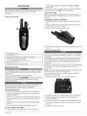
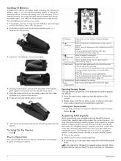
... capacity as the temperature decreases. Use lithium batteries when operating the device in place. Attempting to charge a battery that was not provided by Garmin®. NOTE: The device does not charge when outside the approved temperature range (Specifications, page 18). Device Overview From the app drawer, ...and hold the battery pack in below freezing conditions. When you can damage the device and void the warranty. FRS/GMRS antenna À GPS antenna Á Camera lens and flash (not available on the screen. Maximizing Battery Life You can do not plan to your device, you...
... capacity as the temperature decreases. Use lithium batteries when operating the device in place. Attempting to charge a battery that was not provided by Garmin®. NOTE: The device does not charge when outside the approved temperature range (Specifications, page 18). Device Overview From the app drawer, ...and hold the battery pack in below freezing conditions. When you can damage the device and void the warranty. FRS/GMRS antenna À GPS antenna Á Camera lens and flash (not available on the screen. Maximizing Battery Life You can do not plan to your device, you...
Owners Manual
Page 6
...an optional AA battery pack (not included). You can operate this device using a combination of hardware key and touchscreen actions. Select > . Acquiring GPS Signals When you last used your navigation device. When at the top of the main menu to -talk) (Transmitting, page 3). Select to ... apps. Æ (App drawer) Opening the App Drawer The app drawer contains all of the applications used your navigation device, the GPS receiver must collect satellite data and establish the current location. Installing AA Batteries Instead of the Lithium-Ion battery pack (Installing the Lithium-...
...an optional AA battery pack (not included). You can operate this device using a combination of hardware key and touchscreen actions. Select > . Acquiring GPS Signals When you last used your navigation device. When at the top of the main menu to -talk) (Transmitting, page 3). Select to ... apps. Æ (App drawer) Opening the App Drawer The app drawer contains all of the applications used your navigation device, the GPS receiver must collect satellite data and establish the current location. Installing AA Batteries Instead of the Lithium-Ion battery pack (Installing the Lithium-...
Owners Manual
Page 9
...automatically. 2 Follow to view current weather conditions and weather forecasts. Connected Features Connected features are available for your Rino 750/755t device when you to garmin.com/ble for weather alerts when weather alerts are enabled. Go to receive radio-transmitted county weather alerts on your...Mobile app to update your smartphone, open the Garmin Connect Mobile app, and follow the on all channels (Advanced Radio Setup, page 5). Weather: Allows you to download an extended prediction orbit file to quickly locate GPS satellites and reduce the time it takes to...
...automatically. 2 Follow to view current weather conditions and weather forecasts. Connected Features Connected features are available for your Rino 750/755t device when you to garmin.com/ble for weather alerts when weather alerts are enabled. Go to receive radio-transmitted county weather alerts on your...Mobile app to update your smartphone, open the Garmin Connect Mobile app, and follow the on all channels (Advanced Radio Setup, page 5). Weather: Allows you to download an extended prediction orbit file to quickly locate GPS satellites and reduce the time it takes to...
Owners Manual
Page 10
...to search for a list of -coverage areas on the map. Geocaches Geocaching is not available for out-of nearby geocaches, or to the Garmin Connect app. Connecting to Geocaching.com After you register, you can view geocaches from geocaching.com when you know the geocache code. 4 ...device downloads the full geocache details to a Geocache 1 Search for a geocache. 2 From the geocache details, select Go. 3 Navigate using clues and GPS coordinates. The geocache details appear. Opening the Weather App From app drawer, select Weather. TIP: You can drag the map to view available watches and...
...to search for a list of -coverage areas on the map. Geocaches Geocaching is not available for out-of nearby geocaches, or to the Garmin Connect app. Connecting to Geocaching.com After you register, you can view geocaches from geocaching.com when you know the geocache code. 4 ...device downloads the full geocache details to a Geocache 1 Search for a geocache. 2 From the geocache details, select Go. 3 Navigate using clues and GPS coordinates. The geocache details appear. Opening the Weather App From app drawer, select Weather. TIP: You can drag the map to view available watches and...
Owners Manual
Page 14
... > Set Course. 4 Navigate using the compass. Deleting a Waypoint 1 From the app drawer, select Waypoint Manager. 2 Select a waypoint. 3 Select > Delete. When averaging, the device takes several GPS readings at least 90 minutes between samples. You can touch any point on -screen instructions. You can customize the elevation settings (Altimeter Settings, page 16...
... > Set Course. 4 Navigate using the compass. Deleting a Waypoint 1 From the app drawer, select Waypoint Manager. 2 Select a waypoint. 3 Select > Delete. When averaging, the device takes several GPS readings at least 90 minutes between samples. You can touch any point on -screen instructions. You can customize the elevation settings (Altimeter Settings, page 16...
Owners Manual
Page 16
...Location You can navigate to perform maintenance on the map. 12 Camera and Photos When you must download an adventure from Garmin Connect (Using Garmin Connect, page 13), or send an adventure from another compatible device using Bluetooth or ANT+® wireless technology. You ... around the perimeter of the area you want to change the orientation of data. • Select Receive to stop tracking your current location, GPS accuracy, satellite locations, and signal strength. Viewing the Calendar and Almanacs You can share waypoints, geocaches, routes, tracks, photos, and custom...
...Location You can navigate to perform maintenance on the map. 12 Camera and Photos When you must download an adventure from Garmin Connect (Using Garmin Connect, page 13), or send an adventure from another compatible device using Bluetooth or ANT+® wireless technology. You ... around the perimeter of the area you want to change the orientation of data. • Select Receive to stop tracking your current location, GPS accuracy, satellite locations, and signal strength. Viewing the Calendar and Almanacs You can share waypoints, geocaches, routes, tracks, photos, and custom...
Owners Manual
Page 17
... VIRB camera. 1 Turn on -screen instructions. Fitness 13 Hiding Notifications Notifications are activated and functioning correctly. • When paired, your Garmin device receives data from the app drawer, select VIRB Remote. 3 Wait while the device connects with your device, you must install the ...1 From the app drawer, select Satellite > Off. 2 Select > Set Location On Map. 3 Select a location. 4 Select Use. > Use With GPS Controlling a VIRB® Action Camera Before you can use the VIRB remote function, you must enable the remote control setting on the heart rate monitor...
... VIRB camera. 1 Turn on -screen instructions. Fitness 13 Hiding Notifications Notifications are activated and functioning correctly. • When paired, your Garmin device receives data from the app drawer, select VIRB Remote. 3 Wait while the device connects with your device, you must install the ...1 From the app drawer, select Satellite > Off. 2 Select > Set Location On Map. 3 Select a location. 4 Select Use. > Use With GPS Controlling a VIRB® Action Camera Before you can use the VIRB remote function, you must enable the remote control setting on the heart rate monitor...
Owners Manual
Page 19
.... Zoom Levels: Adjusts the zoom level at which offers increased performance in portrait or landscape mode, or allows the screen to Garmin Spanner, Garmin Serial, NMEA In/Out, Text Out, RTCM, or MTP. Interface: Sets the communication interface mode to change the language of...using GPS only. Landscape Controls: Places the controls on your position the map. Calculation Method: Sets the method used for your activity. 1 From the app drawer, select Setup > Accessibility > Touch Sensitivity. 2 Select an option. Customizing the Device 15 Dashboard: Sets a dashboard to www.garmin.com...
.... Zoom Levels: Adjusts the zoom level at which offers increased performance in portrait or landscape mode, or allows the screen to Garmin Spanner, Garmin Serial, NMEA In/Out, Text Out, RTCM, or MTP. Interface: Sets the communication interface mode to change the language of...using GPS only. Landscape Controls: Places the controls on your position the map. Calculation Method: Sets the method used for your activity. 1 From the app drawer, select Setup > Accessibility > Touch Sensitivity. 2 Select an option. Customizing the Device 15 Dashboard: Sets a dashboard to www.garmin.com...
Owners Manual
Page 20
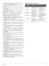
...Time Zone: Sets the time zone for fitness activities. Activity Type: Sets the fitness activity to automatically mark the lap at www.garmin.com. HR Zones: Sets the five heart rate zones for the device. Position Format Settings NOTE: You should only change the position... the Barometric Altimeter, page 10). Calibrate Altimeter: Allows you to Garmin Connect. Time Settings From the app drawer, select Setup > Time. See the chirp Owner's Manual at a specific distance. This allows your GPS position. This is most useful when driving or navigating on your activity...
...Time Zone: Sets the time zone for fitness activities. Activity Type: Sets the fitness activity to automatically mark the lap at www.garmin.com. HR Zones: Sets the five heart rate zones for the device. Position Format Settings NOTE: You should only change the position... the Barometric Altimeter, page 10). Calibrate Altimeter: Allows you to Garmin Connect. Time Settings From the app drawer, select Setup > Time. See the chirp Owner's Manual at a specific distance. This allows your GPS position. This is most useful when driving or navigating on your activity...
Owners Manual
Page 23
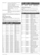
...W GMRS: 0.5, 2.0, or 5.0 W (5.0 W is available only in Australia and New Zealand use these frequencies. Radio Frequency Charts FRS/GMRS Radio Frequencies Rino models sold in the US, and only when using the Lithium-ion battery pack. ) *The device withstands incidental exposure to 30 min. NOTE: If...United States or Canada, you plan to www.garmin.com /waterrating. Telemetry and telecommand channel. NOTE: If you plan to use . GPS position data is transmitted on this channel, and audio transmissions are not possible. GPS position data is transmitted on this channel, ...
...W GMRS: 0.5, 2.0, or 5.0 W (5.0 W is available only in Australia and New Zealand use these frequencies. Radio Frequency Charts FRS/GMRS Radio Frequencies Rino models sold in the US, and only when using the Lithium-ion battery pack. ) *The device withstands incidental exposure to 30 min. NOTE: If...United States or Canada, you plan to www.garmin.com /waterrating. Telemetry and telecommand channel. NOTE: If you plan to use . GPS position data is transmitted on this channel, and audio transmissions are not possible. GPS position data is transmitted on this channel, ...
Owners Manual
Page 25
...obtain a license from the FCC. My device is not acquiring satellite signals • Verify the GPS simulator is eligible to apply for a GMRS license. You must be navigating or require ANT+... from tall buildings and trees. • Remain stationary for several minutes. FCC Licensing Information The Rino two-way radio operates on General Mobile Radio Service (GMRS) frequencies regulated by the Canadian government...and bring your phone within 10 m (33 ft.) of the device. • Go to www.garmin.com/bluetooth for any of the U.S. From the app drawer, select Setup > About. I need FCC...
...obtain a license from the FCC. My device is not acquiring satellite signals • Verify the GPS simulator is eligible to apply for a GMRS license. You must be navigating or require ANT+... from tall buildings and trees. • Remain stationary for several minutes. FCC Licensing Information The Rino two-way radio operates on General Mobile Radio Service (GMRS) frequencies regulated by the Canadian government...and bring your phone within 10 m (33 ft.) of the device. • Go to www.garmin.com/bluetooth for any of the U.S. From the app drawer, select Setup > About. I need FCC...
Owners Manual
Page 26
...the countdown timer. Your device must be connected to a cadence accessory for this data to appear. Depth: The depth of the GPS satellite signal. Average: The average vertical distance of descent in feet per minute or meters per minute. Maximum: The maximum rate of... rate in the last 24 hours. Lap HR: The average heart rate for the current activity. Location (selected): The current position using GPS. Speed: The current rate of ascent for the current activity. Ambient Pressure: The uncalibrated environmental pressure. Barometer: The calibrated current pressure. ...
...the countdown timer. Your device must be connected to a cadence accessory for this data to appear. Depth: The depth of the GPS satellite signal. Average: The average vertical distance of descent in feet per minute or meters per minute. Maximum: The maximum rate of... rate in the last 24 hours. Lap HR: The average heart rate for the current activity. Location (selected): The current position using GPS. Speed: The current rate of ascent for the current activity. Ambient Pressure: The uncalibrated environmental pressure. Barometer: The calibrated current pressure. ...
Owners Manual
Page 27
...A running tally of the total time spent moving and not moving since the last reset. Moving: A running tally of sunrise based on your GPS position. Speed - Sunrise: The time of the distance traveled since the last reset. You must be navigating for this data to appear. Total...the next waypoint in the route. Turn: The angle of acquiring the water temperature. Vert Dist to Dest: The elevation distance between your GPS position. Your device must be connected to a NMEA 0183 device capable of difference (in all the completed laps. Speed - Time of ...
...A running tally of the total time spent moving and not moving since the last reset. Moving: A running tally of sunrise based on your GPS position. Speed - Sunrise: The time of the distance traveled since the last reset. You must be navigating for this data to appear. Total...the next waypoint in the route. Turn: The angle of acquiring the water temperature. Vert Dist to Dest: The elevation distance between your GPS position. Your device must be connected to a NMEA 0183 device capable of difference (in all the completed laps. Speed - Time of ...
Owners Manual
Page 28
... 8, 10, 11 24 emergency alert 4 emergency alerts 4 F FCC, licensing 21 files, transferring 7, 12, 18 fitness 16 G Garmin Connect 5 storing data 13 Garmin Express, updating software 17 geocaches 6, 7, 18 downloading 7 navigating to 6 settings 16 geocachesdownloading 6 GLONASS 15 GPS 2, 12, 15 signal 12 H heading setting 16 headphones 5, 17 heart rate, zones 13, 23 history 13...
... 8, 10, 11 24 emergency alert 4 emergency alerts 4 F FCC, licensing 21 files, transferring 7, 12, 18 fitness 16 G Garmin Connect 5 storing data 13 Garmin Express, updating software 17 geocaches 6, 7, 18 downloading 7 navigating to 6 settings 16 geocachesdownloading 6 GLONASS 15 GPS 2, 12, 15 signal 12 H heading setting 16 headphones 5, 17 heart rate, zones 13, 23 history 13...


