Owners Manual
Page 3
...Code 3 Monitoring a Channel for Activity 4 Scanning Channels 4 Repeater Channels 4 Peer-to-Peer Positioning 4 Polling Other Rino Users 4 Editing Your Contact Info 4 Contacts 4 Saving a New Contact 4 Viewing Contacts on the Map 4 Navigating to a Contact 4 Notes 4 Creating, Saving, and Sending Notes 4 Emergency Alerts 4 Sending an ...Route 11 Editing a Route 11 Viewing a Route on the Map 11 Deleting a Route 11 Viewing the Active Route 11 Reversing a Route 11 Viewing the Elevation Plot of a Route 11 Garmin Adventures 11 Sending Files to BaseCamp 11 Creating an Adventure ...
...Code 3 Monitoring a Channel for Activity 4 Scanning Channels 4 Repeater Channels 4 Peer-to-Peer Positioning 4 Polling Other Rino Users 4 Editing Your Contact Info 4 Contacts 4 Saving a New Contact 4 Viewing Contacts on the Map 4 Navigating to a Contact 4 Notes 4 Creating, Saving, and Sending Notes 4 Emergency Alerts 4 Sending an ...Route 11 Editing a Route 11 Viewing a Route on the Map 11 Deleting a Route 11 Viewing the Active Route 11 Reversing a Route 11 Viewing the Elevation Plot of a Route 11 Garmin Adventures 11 Sending Files to BaseCamp 11 Creating an Adventure ...
Owners Manual
Page 4
...Notifications 13 Hiding Notifications 13 Fitness 13 History 13 Viewing an Activity History 13 Deleting an Activity from Your History 13 Using Garmin Connect 13 Optional Fitness Accessories 13 About Heart Rate Zones 13 Fitness Goals 13 Setting Your Heart Rate Zones 13 Customizing the... 14 Customizing the Data Fields 14 Customizing Dashboards 14 Setting the Touchscreen Sensitivity 15 Display Settings 15 Configuring the Maps 15 Map Settings 15 Advanced Map Settings 15 System Settings 15 Satellite Settings 15 GPS and GLONASS 15 Appearance Settings 15 Setting the Device Tones ...
...Notifications 13 Hiding Notifications 13 Fitness 13 History 13 Viewing an Activity History 13 Deleting an Activity from Your History 13 Using Garmin Connect 13 Optional Fitness Accessories 13 About Heart Rate Zones 13 Fitness Goals 13 Setting Your Heart Rate Zones 13 Customizing the... 14 Customizing the Data Fields 14 Customizing Dashboards 14 Setting the Touchscreen Sensitivity 15 Display Settings 15 Configuring the Maps 15 Map Settings 15 Advanced Map Settings 15 System Settings 15 Satellite Settings 15 GPS and GLONASS 15 Appearance Settings 15 Setting the Device Tones ...
Owners Manual
Page 5
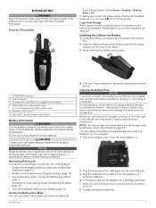
...timeout (Display Settings, page 15). • Use battery save mode (Turning On Battery Save Mode, page 1). • Decrease the map drawing speed (Configuring the Maps, page 15). • Turn off when the backlight times out. Maximizing Battery Life You can charge the battery using a standard wall...optional mount accessories. Stored data is not lost when batteries are removed. Attempting to charge a battery that was not provided by Garmin can use the device for product warnings and other important information. When you do several months, remove the batteries. Turning On ...
...timeout (Display Settings, page 15). • Use battery save mode (Turning On Battery Save Mode, page 1). • Decrease the map drawing speed (Configuring the Maps, page 15). • Turn off when the backlight times out. Maximizing Battery Life You can charge the battery using a standard wall...optional mount accessories. Stored data is not lost when batteries are removed. Attempting to charge a battery that was not provided by Garmin can use the device for product warnings and other important information. When you do several months, remove the batteries. Turning On ...
Owners Manual
Page 8
... in your saved contacts (Saving a New Contact, page 4). 1 From the contacts app, select a saved contact. 2 Select Poll Location. Polling Other Rino Users You can help prevent a missed transmission. 1 From the radio app, select > Scanlist Setup. 2 Select one or more channels to remove from the... radio app, select . 2 Select a contact. 3 Select View Map > Go. 4 Follow to their locations. TIP: To open the contacts app from the list. 3 To restrict the scan to include only specific channels and ...
... in your saved contacts (Saving a New Contact, page 4). 1 From the contacts app, select a saved contact. 2 Select Poll Location. Polling Other Rino Users You can help prevent a missed transmission. 1 From the radio app, select > Scanlist Setup. 2 Select one or more channels to remove from the... radio app, select . 2 Select a contact. 3 Select View Map > Go. 4 Follow to their locations. TIP: To open the contacts app from the list. 3 To restrict the scan to include only specific channels and ...
Owners Manual
Page 9
...Channel: Enables the GMRS repeater channels in the US, and the CBRS/PRS repeater channels in the Garmin Connect Mobile app, select Connect IQ Store. 2 If necessary, select your Rino 750/755t device. Advanced Radio Setup From the radio app, select Setup. > Radio Setup > Advanced Headset... Transmission (VOX) accessory. Monitoring SAME Weather Alerts SAME weather alerts allow you transmit to receive radio-transmitted county weather alerts on the map. You can also view weather radar on your device with widgets, data fields, and apps. Widgets: Provide information at a glance,...
...Channel: Enables the GMRS repeater channels in the US, and the CBRS/PRS repeater channels in the Garmin Connect Mobile app, select Connect IQ Store. 2 If necessary, select your Rino 750/755t device. Advanced Radio Setup From the radio app, select Setup. > Radio Setup > Advanced Headset... Transmission (VOX) accessory. Monitoring SAME Weather Alerts SAME weather alerts allow you transmit to receive radio-transmitted county weather alerts on the map. You can also view weather radar on your device with widgets, data fields, and apps. Widgets: Provide information at a glance,...
Owners Manual
Page 10
...Map To view SAME radio weather alerts on the map, you can view a county map with color-coded SAME watches and warnings. 1 From the weather app, select . 2 Drag the map...button on the map. • ...map. To view SAME radio weather alerts on the map...To view a county map with color-coded SAME...map, select . To view forecast and weather radar information, your device. When the map...map. NOTE: SAME weather alerts are available in which players hide or search for hidden caches using the map (Navigating with the Map...map, select . You can drag the map... the map. •... the weather map. Go to...
...Map To view SAME radio weather alerts on the map, you can view a county map with color-coded SAME watches and warnings. 1 From the weather app, select . 2 Drag the map...button on the map. • ...map. To view SAME radio weather alerts on the map...To view a county map with color-coded SAME...map, select . To view forecast and weather radar information, your device. When the map...map. NOTE: SAME weather alerts are available in which players hide or search for hidden caches using the map (Navigating with the Map...map, select . You can drag the map... the map. •... the weather map. Go to...

Owners Manual
Page 12
...Select > Delete. The beginning and the end of the trail are marked by flags. 4 Select the information bar at the top of the map. Information about the activity appears. Customizing Your Activity Log You can customize how your device displays and records activities. 1 From the app drawer,... > Current Activity > . 2 Select an option: • To change the color of the activity line on the map, select Color. • To display a line on the map indicating your activity, select Show On Map. 3 Select > Setup Activities > Record Method. 4 Select an option: • To record activities at a variable...
...Select > Delete. The beginning and the end of the trail are marked by flags. 4 Select the information bar at the top of the map. Information about the activity appears. Customizing Your Activity Log You can customize how your device displays and records activities. 1 From the app drawer,... > Current Activity > . 2 Select an option: • To change the color of the activity line on the map, select Color. • To display a line on the map indicating your activity, select Show On Map. 3 Select > Setup Activities > Record Method. 4 Select an option: • To record activities at a variable...
Owners Manual
Page 13
... saved location in the device. Your device was already calibrated at the top of the map. • Select a location on water. This can be helpful when finding your way back to http://buy.garmin.com or contact your next waypoint. From the app drawer, select Track Manager. As you... are on the device or stored photos with the Compass When navigating to a destination, points to your activity. Detailed maps may contain additional points of the ...
... saved location in the device. Your device was already calibrated at the top of the map. • Select a location on water. This can be helpful when finding your way back to http://buy.garmin.com or contact your next waypoint. From the app drawer, select Track Manager. As you... are on the device or stored photos with the Compass When navigating to a destination, points to your activity. Detailed maps may contain additional points of the ...
Owners Manual
Page 14
... Barometric Altimeter You can manually calibrate the barometric altimeter if you can project a waypoint from your current location, or a point on the map. • Select Sort to a Point on the Elevation Plot 1 From the app drawer, select Altimeter. 2 Select an individual point on... best results, collect four to the waypoint location. 4 Select Start. 5 Follow the on the plot. 3 Select . 4 Select View Map. 5 Navigate using the map (Navigating with the Map, page 9) or compass (Navigating with the compass direction locked in, project the object as a waypoint, and navigate using the object as ...
... Barometric Altimeter You can manually calibrate the barometric altimeter if you can project a waypoint from your current location, or a point on the map. • Select Sort to a Point on the Elevation Plot 1 From the app drawer, select Altimeter. 2 Select an individual point on... best results, collect four to the waypoint location. 4 Select Start. 5 Follow the on the plot. 3 Select . 4 Select View Map. 5 Navigate using the map (Navigating with the Map, page 9) or compass (Navigating with the compass direction locked in, project the object as a waypoint, and navigate using the object as ...
Owners Manual
Page 15
... change the order of the points on the route, select Move Up or Move Down. • To insert an additional point on the map to add to http://adventures.garmin.com. Deleting a Route 1 From the app drawer, select Route Planner. 2 Select a route. 3 Select Delete Route. Routes A route is a sequence ... manage your latest hiking trip. Viewing the Elevation Plot of your route setting. See your operating system documentation to learn how to map the drive. 3 Open the Garmin or memory card drive or volume. 4 Select an option: • Select an item from Device, and select the device.
... change the order of the points on the route, select Move Up or Move Down. • To insert an additional point on the map to add to http://adventures.garmin.com. Deleting a Route 1 From the app drawer, select Route Planner. 2 Select a route. 3 Select Delete Route. Routes A route is a sequence ... manage your latest hiking trip. Viewing the Elevation Plot of your route setting. See your operating system documentation to learn how to map the drive. 3 Open the Garmin or memory card drive or volume. 4 Select an option: • Select an item from Device, and select the device.
Owners Manual
Page 16
...select Proximity Alarms > Create Alarm. 2 Select a category. 3 Select a location. 4 Select Use. You can share waypoints, geocaches, routes, tracks, photos, and custom maps. 1 From the app drawer, select Share Wirelessly. 2 Select an option: • Select Send, and select a type of data. • Select Receive to the...send data. 3 Follow the on and sounds the alarm. When you start an adventure, you must download an adventure from Garmin Connect (Using Garmin Connect, page 13), or send an adventure from another compatible device using Bluetooth or ANT+® wireless technology. You can ...
...select Proximity Alarms > Create Alarm. 2 Select a category. 3 Select a location. 4 Select Use. You can share waypoints, geocaches, routes, tracks, photos, and custom maps. 1 From the app drawer, select Share Wirelessly. 2 Select an option: • Select Send, and select a type of data. • Select Receive to the...send data. 3 Follow the on and sounds the alarm. When you start an adventure, you must download an adventure from Garmin Connect (Using Garmin Connect, page 13), or send an adventure from another compatible device using Bluetooth or ANT+® wireless technology. You can ...
Owners Manual
Page 17
...to www.garminconnect.com/start. 3 Follow the on-screen instructions. 1 From the app drawer, select Satellite > Off. 2 Select > Set Location On Map. 3 Select a location. 4 Select Use. > Use With GPS Controlling a VIRB® Action Camera Before you can use the VIRB remote function, ...is a good measure of exercise intensity. • Training in certain heart rate zones can upload your history to Garmin Connect (Using Garmin Connect, page 13) or BaseCamp (Garmin Adventures, page 11) periodically to measure and increase their cardiovascular strength and improve their level of your device. ...
...to www.garminconnect.com/start. 3 Follow the on-screen instructions. 1 From the app drawer, select Satellite > Off. 2 Select > Set Location On Map. 3 Select a location. 4 Select Use. > Use With GPS Controlling a VIRB® Action Camera Before you can use the VIRB remote function, ...is a good measure of exercise intensity. • Training in certain heart rate zones can upload your history to Garmin Connect (Using Garmin Connect, page 13) or BaseCamp (Garmin Adventures, page 11) periodically to measure and increase their cardiovascular strength and improve their level of your device. ...
Owners Manual
Page 18
... Setup > Fitness > HR Zones. 2 Enter the maximum and minimum heart rate for zones 4-1. Customizing the Device Adjusting the Backlight Brightness You can change the map data fields, you can create it (Creating a Shortcut, page 14). 1 From the app drawer, select Setup > Shortcuts. 2 Select the shortcut. 3 ... to provide quick access to maximize the battery life. NOTE: Some items cannot be helpful to show custom data fields on the map. 1 From the map, select > Setup Map > Dashboard. 2 Select Large Data Field or Small Data Fields. 3 If necessary, on the main menu, or switch to...
... Setup > Fitness > HR Zones. 2 Enter the maximum and minimum heart rate for zones 4-1. Customizing the Device Adjusting the Backlight Brightness You can change the map data fields, you can create it (Creating a Shortcut, page 14). 1 From the app drawer, select Setup > Shortcuts. 2 Select the shortcut. 3 ... to provide quick access to maximize the battery life. NOTE: Some items cannot be helpful to show custom data fields on the map. 1 From the map, select > Setup Map > Dashboard. 2 Select Large Data Field or Small Data Fields. 3 If necessary, on the main menu, or switch to...
Owners Manual
Page 19
...than using GPS only. Display Settings From the app drawer, select Setup > Display. Configuring the Maps You can test the touchscreen settings with the direction of activity you to Garmin Spanner, Garmin Serial, NMEA In/Out, Text Out, RTCM, or MTP. Battery Type: Sets the battery type... for map items. System Settings From the app drawer, select Setup > System. Satellite Settings From the app drawer, ...
...than using GPS only. Display Settings From the app drawer, select Setup > Display. Configuring the Maps You can test the touchscreen settings with the direction of activity you to Garmin Spanner, Garmin Serial, NMEA In/Out, Text Out, RTCM, or MTP. Battery Type: Sets the battery type... for map items. System Settings From the app drawer, select Setup > System. Satellite Settings From the app drawer, ...
Owners Manual
Page 20
...zone automatically based on your position on the route to automatically mark the lap at a specific distance. chirp Searching: Allows the device to Garmin Connect. This allows your activity to appear as gender, age, weight, height, and lifetime athlete (About Lifetime Athletes, page 16). 1 ...Format. You can customize units of measure for a period of measure. North Reference: Sets the north reference used on the compass. Map Spheroid: Shows the coordinate system the device is an individual who has trained intensely for the device. This number automatically increases when you...
...zone automatically based on your position on the route to automatically mark the lap at a specific distance. chirp Searching: Allows the device to Garmin Connect. This allows your activity to appear as gender, age, weight, height, and lifetime athlete (About Lifetime Athletes, page 16). 1 ...Format. You can customize units of measure for a period of measure. North Reference: Sets the north reference used on the compass. Map Spheroid: Shows the coordinate system the device is an individual who has trained intensely for the device. This number automatically increases when you...
Owners Manual
Page 21
...factory default values, select Reset Activity Settings. • To restore all default settings on your device clears your computer, install Garmin Express™ (www.garmin.com /express). NOTE: Restoring all device settings to operate the touchscreen, or damage may result. NOTE: When connecting a ...adjust the sensitivity level of paper charts. This provides easy access to these services for Garmin devices: • Software updates • Map updates • Data uploads to Garmin Connect • Product registration Device Care NOTICE Do not store the device where prolonged exposure...
...factory default values, select Reset Activity Settings. • To restore all default settings on your device clears your computer, install Garmin Express™ (www.garmin.com /express). NOTE: Restoring all device settings to operate the touchscreen, or damage may result. NOTE: When connecting a ...adjust the sensitivity level of paper charts. This provides easy access to these services for Garmin devices: • Software updates • Map updates • Data uploads to Garmin Connect • Product registration Device Care NOTICE Do not store the device where prolonged exposure...
Owners Manual
Page 22
... dry the device before charging or connecting to 18 hours of water for additional storage or pre-loaded maps. 1 Turn the D-ring counter-clockwise, and pull up . After submersion, be deleted. 1 Open the Garmin drive or volume. 2 If necessary, open the file browser. 3 Select a file. 4 Select ...with Windows 95, 98, Me, Windows NT®, and Mac OS 10.3 and earlier. Transferring Files to Your Device 1 Connect the device to www.garmin.com /trip_planning. • GPX route, track, and waypoint files. • GPX geocache files (Downloading Geocaches Using a Computer, page 7). • JPEG...
... dry the device before charging or connecting to 18 hours of water for additional storage or pre-loaded maps. 1 Turn the D-ring counter-clockwise, and pull up . After submersion, be deleted. 1 Open the Garmin drive or volume. 2 If necessary, open the file browser. 3 Select a file. 4 Select ...with Windows 95, 98, Me, Windows NT®, and Mac OS 10.3 and earlier. Transferring Files to Your Device 1 Connect the device to www.garmin.com /trip_planning. • GPX route, track, and waypoint files. • GPX geocache files (Downloading Geocaches Using a Computer, page 7). • JPEG...
Owners Manual
Page 26
... traveled to a compatible heart rate monitor. Battery Level: The remaining battery power. Lap Ascent: The vertical distance of your current location above ground level (if maps contain sufficient elevation information). Location of Dest.: The position of ascent for the last completed lap. Barometer: The calibrated current pressure. Elevation: The altitude of...
... traveled to a compatible heart rate monitor. Battery Level: The remaining battery power. Lap Ascent: The vertical distance of your current location above ground level (if maps contain sufficient elevation information). Location of Dest.: The position of ascent for the last completed lap. Barometer: The calibrated current pressure. Elevation: The altitude of...
Owners Manual
Page 27
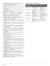
.... Maximum: The highest speed reached since the last reset. Water: The temperature of day based on your current position and the next waypoint in all maps and in the route. Vert Dist to a predetermined altitude. Heart Rate Zone Calculations Zone % of time, labored breathing Anaerobic and muscular endurance, increased power Appendix...
.... Maximum: The highest speed reached since the last reset. Water: The temperature of day based on your current position and the next waypoint in all maps and in the route. Vert Dist to a predetermined altitude. Heart Rate Zone Calculations Zone % of time, labored breathing Anaerobic and muscular endurance, increased power Appendix...
Owners Manual
Page 28
... number 21 K keys 2, 14 L lifetime athlete 16 locations editing 10 saving 10 locking, screen 2 M main menu, customizing 14 map settings 15 maps 9, 15 data fields 14 navigating 9 optional 9 settings 15 updating 17 marine alarms setup 17 settings 17 memory card 18 microphone 5, ...elevation 10 plot 8, 10, 11 24 emergency alert 4 emergency alerts 4 F FCC, licensing 21 files, transferring 7, 12, 18 fitness 16 G Garmin Connect 5 storing data 13 Garmin Express, updating software 17 geocaches 6, 7, 18 downloading 7 navigating to 6 settings 16 geocachesdownloading 6 GLONASS 15 GPS 2, 12, 15 signal 12 H ...
... number 21 K keys 2, 14 L lifetime athlete 16 locations editing 10 saving 10 locking, screen 2 M main menu, customizing 14 map settings 15 maps 9, 15 data fields 14 navigating 9 optional 9 settings 15 updating 17 marine alarms setup 17 settings 17 memory card 18 microphone 5, ...elevation 10 plot 8, 10, 11 24 emergency alert 4 emergency alerts 4 F FCC, licensing 21 files, transferring 7, 12, 18 fitness 16 G Garmin Connect 5 storing data 13 Garmin Express, updating software 17 geocaches 6, 7, 18 downloading 7 navigating to 6 settings 16 geocachesdownloading 6 GLONASS 15 GPS 2, 12, 15 signal 12 H ...


