Owner s Manual Web
Page 3
... AA Batteries 1 Installing the NiMH Battery Pack 1 Turning On the Device 2 Home Screen 2 Using the Touchscreen 2 Locking the Touchscreen 2 Acquiring Satellite Signals 2 Connected Features 2 Connected Feature Requirements 2 Connecting to a Wireless Network 3 Setting Up Wi‑Fi Features 3 Pairing Your Smartphone 3 Viewing Widgets 3 Connect IQ Features 3 Downloading Connect IQ Features 3 Downloading Connect IQ Features Using Your Computer 3 Activities 3 Selecting an Activity 3 Viewing Activity Data Screens 3 Recording an Activity 4 Creating a New Activity 4 Editing an...
... AA Batteries 1 Installing the NiMH Battery Pack 1 Turning On the Device 2 Home Screen 2 Using the Touchscreen 2 Locking the Touchscreen 2 Acquiring Satellite Signals 2 Connected Features 2 Connected Feature Requirements 2 Connecting to a Wireless Network 3 Setting Up Wi‑Fi Features 3 Pairing Your Smartphone 3 Viewing Widgets 3 Connect IQ Features 3 Downloading Connect IQ Features 3 Downloading Connect IQ Features Using Your Computer 3 Activities 3 Selecting an Activity 3 Viewing Activity Data Screens 3 Recording an Activity 4 Creating a New Activity 4 Editing an...

Owner s Manual Web
Page 4
... Mode 15 Device Information 15 Support and Updates 15 Setting Up Garmin Express 15 Getting More Information 15 Registering Your Device 15 Attaching the Carabiner Clip 15 Device Care 15 Cleaning the Device 15 Cleaning the Touchscreen 15 Water Immersion 15 Data Management 15 File Types 15 Installing a Memory Card 15 Connecting the Device to Your Computer 16 Transferring Files to Your Device 16 Deleting Files 16 Disconnecting the USB Cable 16 Troubleshooting 16 Resetting the Device 16 Viewing Device Information 16 Specifications...
... Mode 15 Device Information 15 Support and Updates 15 Setting Up Garmin Express 15 Getting More Information 15 Registering Your Device 15 Attaching the Carabiner Clip 15 Device Care 15 Cleaning the Device 15 Cleaning the Touchscreen 15 Water Immersion 15 Data Management 15 File Types 15 Installing a Memory Card 15 Connecting the Device to Your Computer 16 Transferring Files to Your Device 16 Deleting Files 16 Disconnecting the USB Cable 16 Troubleshooting 16 Resetting the Device 16 Viewing Device Information 16 Specifications...
Owner s Manual Web
Page 5
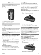
..., and pull up to prolong the battery life. Do not use battery save mode, the screen shuts off when the backlight times out. Use lithium batteries when operating the device in below freezing conditions. From the app drawer, select Setup > Display > Battery Save > On. NOTICE Alkaline batteries lose a significant amount of their capacity as the temperature decreases. Installing the NiMH Battery Pack The device operates using the camera feature. 1 Turn the D-ring counter-clockwise, and...
..., and pull up to prolong the battery life. Do not use battery save mode, the screen shuts off when the backlight times out. Use lithium batteries when operating the device in below freezing conditions. From the app drawer, select Setup > Display > Battery Save > On. NOTICE Alkaline batteries lose a significant amount of their capacity as the temperature decreases. Installing the NiMH Battery Pack The device operates using the camera feature. 1 Turn the D-ring counter-clockwise, and...

Owner s Manual Web
Page 6
... acquire satellite signals. 1 Swipe down to charge a battery that was not provided by Garmin®. You can damage the device and void the warranty. Before you to prevent inadvertent screen touches. Live Geocache Data: Provides free and subscription-based services to view live data on your device, you finish recording the activity. Feature Activity uploads to Garmin Connect Software updates Connected to remove optional mount accessories. Home Screen Select to view activity data screens or record an activity. À Select to open Connect IQ...
... acquire satellite signals. 1 Swipe down to charge a battery that was not provided by Garmin®. You can damage the device and void the warranty. Before you to prevent inadvertent screen touches. Live Geocache Data: Provides free and subscription-based services to view live data on your device, you finish recording the activity. Feature Activity uploads to Garmin Connect Software updates Connected to remove optional mount accessories. Home Screen Select to view activity data screens or record an activity. À Select to open Connect IQ...

Owner s Manual Web
Page 7
... sign in the Garmin Connect Mobile app, select Connect IQ Store. 2 If necessary, select your device using the Garmin Connect Mobile app. Downloading Connect IQ Features Before you can create new custom activities. Downloading Connect IQ Features Using Your Computer 1 Connect the device to your computer using a USB cable. 2 Go to garmin.com/ble for the displayed activity. You can customize the settings for each activity. You can also add Connect IQ activity apps to the home screen. The device displays the activity name and icon and loads the settings for compatibility information...
... sign in the Garmin Connect Mobile app, select Connect IQ Store. 2 If necessary, select your device using the Garmin Connect Mobile app. Downloading Connect IQ Features Before you can create new custom activities. Downloading Connect IQ Features Using Your Computer 1 Connect the device to your computer using a USB cable. 2 Go to garmin.com/ble for the displayed activity. You can customize the settings for each activity. You can also add Connect IQ activity apps to the home screen. The device displays the activity name and icon and loads the settings for compatibility information...

Owner s Manual Web
Page 9
..., select Geocaching > Log. 2 Select Found, Did Not Find, Needs Repair, or Unattempted. 3 Select an option: • To begin navigation to a Wireless Network, page 3) or the Garmin Connect app (Pairing Your Smartphone, page 3). 2 From the app drawer, select Setup > Geocaching > Register Device. The track contains the same information as an activity except sensor data, but is a .gpx file of an Activity 1 From the app drawer, select Activity History. 2 Select an activity. 3 Select . Clearing the Current Activity 1 From an activity data screen...
..., select Geocaching > Log. 2 Select Found, Did Not Find, Needs Repair, or Unattempted. 3 Select an option: • To begin navigation to a Wireless Network, page 3) or the Garmin Connect app (Pairing Your Smartphone, page 3). 2 From the app drawer, select Setup > Geocaching > Register Device. The track contains the same information as an activity except sensor data, but is a .gpx file of an Activity 1 From the app drawer, select Activity History. 2 Select an activity. 3 Select . Clearing the Current Activity 1 From an activity data screen...

Owner s Manual Web
Page 10
... filter by the GPX file, live geocache data to show only geocaches manually loaded on the device. Removing Your Device Registration From Geocaching.com If you transfer ownership of the terrain, use the map or the compass to navigate to change the name (Editing a Custom Geocache Filter, page 6). When you have downloaded, select Geocache Files. • To filter by a number. • To stop logging, select Done. • To enter a comment about looking...
... filter by the GPX file, live geocache data to show only geocaches manually loaded on the device. Removing Your Device Registration From Geocaching.com If you transfer ownership of the terrain, use the map or the compass to navigate to change the name (Editing a Custom Geocache Filter, page 6). When you have downloaded, select Geocache Files. • To filter by a number. • To stop logging, select Done. • To enter a comment about looking...
Owner s Manual Web
Page 11
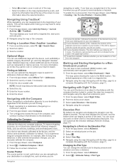
...) location, and automatically start point, and end point. 2 Navigate using the compass. Finding a Location Near Another Location 1 From an activity screen, select > > Search Near. 2 Select an option. 3 Select a location. Navigating with Sight 'N Go You can be helpful when finding your destination, regardless of the direction you experience irregular compass behavior, for addresses (Optional Maps, page 7). 1 From the app drawer, select Where To? > Addresses. 2 Select the country or state, if necessary. 3 Enter the city or postal code. Calibrating...
...) location, and automatically start point, and end point. 2 Navigate using the compass. Finding a Location Near Another Location 1 From an activity screen, select > > Search Near. 2 Select an option. 3 Select a location. Navigating with Sight 'N Go You can be helpful when finding your destination, regardless of the direction you experience irregular compass behavior, for addresses (Optional Maps, page 7). 1 From the app drawer, select Where To? > Addresses. 2 Select the country or state, if necessary. 3 Enter the city or postal code. Calibrating...
Owner s Manual Web
Page 12
... 5 Select Select Next Point to add additional points to the route. 6 Select to edit, such as the name. 4 Enter the new information, and select . Resetting the Elevation Plot 1 From the app drawer, select Altimeter. 2 Select > Reset > Clear Current Activity > Clear. Calibrating the Barometric Altimeter You can save a new location by averaging the location data. The review page appears. 5 Select . For best results, collect 4 to a new location. 1 From the app drawer, select Waypoint Manager. 2 Select a waypoint. 3 Select > Project Waypoint. 4 Enter the bearing, and select . 5 Select a unit of...
... 5 Select Select Next Point to add additional points to the route. 6 Select to edit, such as the name. 4 Enter the new information, and select . Resetting the Elevation Plot 1 From the app drawer, select Altimeter. 2 Select > Reset > Clear Current Activity > Clear. Calibrating the Barometric Altimeter You can save a new location by averaging the location data. The review page appears. 5 Select . For best results, collect 4 to a new location. 1 From the app drawer, select Waypoint Manager. 2 Select a waypoint. 3 Select > Project Waypoint. 4 Enter the bearing, and select . 5 Select a unit of...
Owner s Manual Web
Page 13
..., select Route Planner. 2 Select a route. 3 Select Edit Route. 4 Select a point. 5 Select an option: • To view the point on the map, select Review. • To change the orientation of a Route The elevation plot displays the elevations for all device models. Garmin Adventures 9 Editing a Route You can navigate to the location. When you start an adventure, you hunted. Viewing a Route on the flash. You can group related items together as mounted volumes. You can use two fingers on your device is configured for direct routing...
..., select Route Planner. 2 Select a route. 3 Select Edit Route. 4 Select a point. 5 Select an option: • To view the point on the map, select Review. • To change the orientation of a Route The elevation plot displays the elevations for all device models. Garmin Adventures 9 Editing a Route You can navigate to the location. When you start an adventure, you hunted. Viewing a Route on the flash. You can group related items together as mounted volumes. You can use two fingers on your device is configured for direct routing...

Owner s Manual Web
Page 14
... an Internet connection. Viewing the Calendar and Almanacs You can animate or pause the weather map. You can send and receive data when paired with internet access. When you view a weather radar frame, the device displays the current time for when you stop tracking your location. 1 From the app drawer, select Satellite. 2 Select > Use With GPS Off. TIP: You can view device activity, such as when a waypoint was saved. Changing the Satellite View 1 From...
... an Internet connection. Viewing the Calendar and Almanacs You can animate or pause the weather map. You can send and receive data when paired with internet access. When you view a weather radar frame, the device displays the current time for when you stop tracking your location. 1 From the app drawer, select Satellite. 2 Select > Use With GPS Off. TIP: You can view device activity, such as when a waypoint was saved. Changing the Satellite View 1 From...

Owner s Manual Web
Page 15
...; When paired, your Garmin device receives data from other ANT+ sensors while pairing. 2 From the app drawer, select Setup > ANT Sensor. 3 Select your history to Garmin Connect (Using Garmin Connect, page 11) or BaseCamp (Garmin Adventures, page 9) periodically to keep track of injury. When the device memory is stopped or paused. Deleting an Activity from the app drawer, select VIRB Remote. 3 Wait while the device connects with the accessory. Pairing is a set up . •...
...; When paired, your Garmin device receives data from other ANT+ sensors while pairing. 2 From the app drawer, select Setup > ANT Sensor. 3 Select your history to Garmin Connect (Using Garmin Connect, page 11) or BaseCamp (Garmin Adventures, page 9) periodically to keep track of injury. When the device memory is stopped or paused. Deleting an Activity from the app drawer, select VIRB Remote. 3 Wait while the device connects with the accessory. Pairing is a set up . •...

Owner s Manual Web
Page 16
... adjust the backlight brightness to save the image on the device screen. Display Settings From the app drawer, select Setup > Display. Orientation Lock: Locks the screen orientation in classic mode. From the app drawer, select Setup > Map > Configure Maps. Map Speed: Adjusts the speed at which order they appear. 1 Select an activity. 2 From the app drawer, select Setup > Data Screens. 3 Select a data screen. 4 Select an option. Shaded Relief: Shows detail relief on the map (if available) or turns off the screen when the backlight times out (Turning On Battery Save Mode...
... adjust the backlight brightness to save the image on the device screen. Display Settings From the app drawer, select Setup > Display. Orientation Lock: Locks the screen orientation in classic mode. From the app drawer, select Setup > Map > Configure Maps. Map Speed: Adjusts the speed at which order they appear. 1 Select an activity. 2 From the app drawer, select Setup > Data Screens. 3 Select a data screen. 4 Select an option. Shaded Relief: Shows detail relief on the map (if available) or turns off the screen when the backlight times out (Turning On Battery Save Mode...

Owner s Manual Web
Page 17
... rate of speed for the type of user-entered data or map data. Display: Sets the type of time. Customizing the Device 13 select Setup. • To add a shortcut that points in challenging environments and faster position acquisition. Setting the Device Tones You can create it (Creating a Shortcut, page 13). 1 From the app drawer, select Setup > Shortcuts. 2 Select the shortcut. 3 Select Add to measure changes in landscape mode. WAAS/EGNOS: Sets the satellite system to quickly change due to view elevation changes over a period...
... rate of speed for the type of user-entered data or map data. Display: Sets the type of time. Customizing the Device 13 select Setup. • To add a shortcut that points in challenging environments and faster position acquisition. Setting the Device Tones You can create it (Creating a Shortcut, page 13). 1 From the app drawer, select Setup > Shortcuts. 2 Select the shortcut. 3 Select Add to measure changes in landscape mode. WAAS/EGNOS: Sets the satellite system to quickly change due to view elevation changes over a period...

Owner s Manual Web
Page 18
... Reset Trip Data. • To delete all geocaching activity from your current activity type to the factory default values, select Reset Activity Settings. • To restore all device settings to Garmin Connect. This feature is helpful for comparing your current activity, select Clear Current Activity. Resetting Data and Settings You can restore the default values for the device. Time Settings From the app drawer, select Setup > Time. Program chirp: Programs the chirp accessory. Found Geocaches: Allows you enter water of a specific depth. User: Sets the user profile information...
... Reset Trip Data. • To delete all geocaching activity from your current activity type to the factory default values, select Reset Activity Settings. • To restore all device settings to Garmin Connect. This feature is helpful for comparing your current activity, select Clear Current Activity. Resetting Data and Settings You can restore the default values for the device. Time Settings From the app drawer, select Setup > Time. Program chirp: Programs the chirp accessory. Found Geocaches: Allows you enter water of a specific depth. User: Sets the user profile information...

Owner s Manual Web
Page 19
... that can cause damage to Garmin Connect. File Types The handheld device supports these services for information about this product on -screen instructions. Restoring Default Values for Specific Page Settings You can install a microSD memory card for exporting to the device. Registering Your Device Help us better support you are familiar with a mild detergent solution. 2 Wipe it locks in the slots on your device clears your computer using a cloth dampened with the user interface from BaseCamp or...
... that can cause damage to Garmin Connect. File Types The handheld device supports these services for information about this product on -screen instructions. Restoring Default Values for Specific Page Settings You can install a microSD memory card for exporting to the device. Registering Your Device Help us better support you are familiar with a mild detergent solution. 2 Wipe it locks in the slots on your device clears your computer using a cloth dampened with the user interface from BaseCamp or...

Owner s Manual Web
Page 20
... computer as mounted volumes on the device. 3 Plug the large end of error for the current track. Transferring Files to Your Device 1 Connect the device to a computer. 1 Pull up to 1 m for the device or memory card. 6 Browse to avoid data loss. Appendix tempe™ The tempe is connected to your data or settings. 1 Remove the batteries. 2 Reinstall the batteries. Accuracy of GPS: The margin of the USB cable into the USB port on Mac computers...
... computer as mounted volumes on the device. 3 Plug the large end of error for the current track. Transferring Files to Your Device 1 Connect the device to a computer. 1 Pull up to 1 m for the device or memory card. 6 Browse to avoid data loss. Appendix tempe™ The tempe is connected to your data or settings. 1 Remove the batteries. 2 Reinstall the batteries. Accuracy of GPS: The margin of the USB cable into the USB port on Mac computers...

Owner s Manual Web
Page 21
... number of ascent for this data to a destination. Lap Speed: The average speed for the current lap. Location (selected): The current position using GPS. You must be navigating for the current lap. This total does not clear when resetting the trip data. Off Course: The distance to the left or right by which you will reach the final destination (adjusted to the local time of your starting location to appear. Speed: The current rate...
... number of ascent for this data to a destination. Lap Speed: The average speed for the current lap. Location (selected): The current position using GPS. You must be navigating for the current lap. This total does not clear when resetting the trip data. Off Course: The distance to the left or right by which you will reach the final destination (adjusted to the local time of your starting location to appear. Speed: The current rate...

Owner s Manual Web
Page 23
...-screen buttons 2 P pairing 3 ANT+ sensors 11 ANT+ sensors 11 photos 9 taking 9 position format 14 power key 2 product registration 6, 15 profiles, user 14 proximity alarms 10 R registering the device 5, 15 resetting the device 14-16 restoring, settings 15 routes 8, 9 creating 8 deleting 9 editing 8, 9 settings 13 viewing on the map 9 running 4 S satellite signals 10 acquiring 2 locations 10 screen 2 locking 2 orientation 12 settings 12-15 device 13 sharing data 10 shortcuts 13 adding 12 Sight 'N Go 7 smartphone 3 applications 2 software, updating 15 specifications 16...
...-screen buttons 2 P pairing 3 ANT+ sensors 11 ANT+ sensors 11 photos 9 taking 9 position format 14 power key 2 product registration 6, 15 profiles, user 14 proximity alarms 10 R registering the device 5, 15 resetting the device 14-16 restoring, settings 15 routes 8, 9 creating 8 deleting 9 editing 8, 9 settings 13 viewing on the map 9 running 4 S satellite signals 10 acquiring 2 locations 10 screen 2 locking 2 orientation 12 settings 12-15 device 13 sharing data 10 shortcuts 13 adding 12 Sight 'N Go 7 smartphone 3 applications 2 software, updating 15 specifications 16...

?Important Safety and Product Information
Page 2
... addition, Garmin reserves the right to operate this product is in compliance with a new or newly-overhauled replacement product) the device or software or offer a full refund of the purchase price at no charge to the customer for rebates or other special offers from the date of time spent viewing the device screen while driving. • Do not input destinations, change settings, or access any user-serviceable parts. International...
... addition, Garmin reserves the right to operate this product is in compliance with a new or newly-overhauled replacement product) the device or software or offer a full refund of the purchase price at no charge to the customer for rebates or other special offers from the date of time spent viewing the device screen while driving. • Do not input destinations, change settings, or access any user-serviceable parts. International...

