Owner's Manual
Page 5
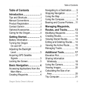
...i Contact Garmin ii Optional Accessories ii Caring for the Oregon ii Getting Started 1 Battery Information 2 Turning the Oregon On and Off 2 Adjusting the Backlight Level 3 Acquiring GPS Satellite Signals 3 Locking the Screen 3 Basic Navigation 4 Accessing Applications from the Main Menu 4 Creating Waypoints 4 Oregon Series Owner's... Editing and Deleting Routes.... 14 Viewing the Active Route......... 15 Managing Tracks 15 Additional Tools 17 Elevation Plot 17 Sharing Information Wirelessly 18 Using the Camera 19 Viewing Images 20 Calculating the Size of an Area 20 Trip ...
...i Contact Garmin ii Optional Accessories ii Caring for the Oregon ii Getting Started 1 Battery Information 2 Turning the Oregon On and Off 2 Adjusting the Backlight Level 3 Acquiring GPS Satellite Signals 3 Locking the Screen 3 Basic Navigation 4 Accessing Applications from the Main Menu 4 Creating Waypoints 4 Oregon Series Owner's... Editing and Deleting Routes.... 14 Viewing the Active Route......... 15 Managing Tracks 15 Additional Tools 17 Elevation Plot 17 Sharing Information Wirelessly 18 Using the Camera 19 Viewing Images 20 Calculating the Size of an Area 20 Trip ...
Owner's Manual
Page 22
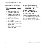
To open a saved track: 1. Archived or loaded tracks are listed on the map, view elevation plots, or navigate the track. 16 Oregon Series Owner's Manual To clear your current track. You can view the tracks on the Track Manager page. Touch a saved track. Touch Where To? > ...To save and view your current track: Touch Track Manager > Current Track. • View Map-shows your current track on the map. • Elevation Plot-shows the elevation plot (page 17) for your current track. • Save Track-saves your current route. • Save Portion-allows you to select a portion of your...
To open a saved track: 1. Archived or loaded tracks are listed on the map, view elevation plots, or navigate the track. 16 Oregon Series Owner's Manual To clear your current track. You can view the tracks on the Track Manager page. Touch a saved track. Touch Where To? > ...To save and view your current track: Touch Track Manager > Current Track. • View Map-shows your current track on the map. • Elevation Plot-shows the elevation plot (page 17) for your current track. • Save Track-saves your current route. • Save Portion-allows you to select a portion of your...
Owner's Manual
Page 23
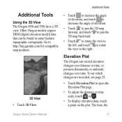
... recorded, see page 32. • Touch Elevation Plot to the right. Other Oregon models require DEM (digital elevation model) data that can record elevation changes over distance or time, or pressure (barometric or ambient) changes over time. Elevation Plot The Oregon can be found in some Garmin topographic cartography. Go to http://buy.garmin.com for compatible map products. 3D...
... recorded, see page 32. • Touch Elevation Plot to the right. Other Oregon models require DEM (digital elevation model) data that can record elevation changes over distance or time, or pressure (barometric or ambient) changes over time. Elevation Plot The Oregon can be found in some Garmin topographic cartography. Go to http://buy.garmin.com for compatible map products. 3D...
Owner's Manual
Page 24
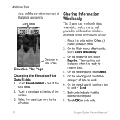
...8. Both units indicate that point are shown. Data fields Distance or time scale Elevation Plot Page Changing the Elevation Plot Data Fields 1. Sharing Information Wirelessly The Oregon can wirelessly share waypoints, routes, tracks, and geocaches with another wirelessenabled Garmin recreational device. 1. Place the units within 10 feet (3 meters) of options....2. On the Main menu of data to send. 6. On the sending unit, touch the category of both units. 18 Oregon Series Owner's Manual Touch Elevation Plot > one of the data fields. 2. Additional Tools date, and the...
...8. Both units indicate that point are shown. Data fields Distance or time scale Elevation Plot Page Changing the Elevation Plot Data Fields 1. Sharing Information Wirelessly The Oregon can wirelessly share waypoints, routes, tracks, and geocaches with another wirelessenabled Garmin recreational device. 1. Place the units within 10 feet (3 meters) of options....2. On the Main menu of data to send. 6. On the sending unit, touch the category of both units. 18 Oregon Series Owner's Manual Touch Elevation Plot > one of the data fields. 2. Additional Tools date, and the...
Owner's Manual
Page 38
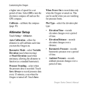
... fronts. Select Off to turn the Oregon on . Touch Save 32 When Power On to function as a standard barometer). This can be useful when you turn the electronic compass off . Plot Type-select the elevation plot type: • Elevation/Time-records elevation changes over a period of time. • Elevation/Distance-records elevation changes over a distance. • Barometric Pressure...
... fronts. Select Off to turn the Oregon on . Touch Save 32 When Power On to function as a standard barometer). This can be useful when you turn the electronic compass off . Plot Type-select the elevation plot type: • Elevation/Time-records elevation changes over a period of time. • Elevation/Distance-records elevation changes over a distance. • Barometric Pressure...
Owner's Manual
Page 49
...Garmin 23 compass calibration 10 north reference 31 course 31 D dashboard 21 Index data fields changing 8, 12, 18, 27 show or hide 8 daylight saving time 30 default settings 40 demo mode 36 directional letters 31 E edit routes 14 waypoints 13 elevation fixed or variable 32 elevation/distance 32 elevation/time 32 elevation plot... 17 customizing 32 F factory settings 40 fitness setup 33 fixed elevation 32 Oregon Series Owner's Manual 43
...Garmin 23 compass calibration 10 north reference 31 course 31 D dashboard 21 Index data fields changing 8, 12, 18, 27 show or hide 8 daylight saving time 30 default settings 40 demo mode 36 directional letters 31 E edit routes 14 waypoints 13 elevation fixed or variable 32 elevation/distance 32 elevation/time 32 elevation plot... 17 customizing 32 F factory settings 40 fitness setup 33 fixed elevation 32 Oregon Series Owner's Manual 43


