Garmin GPS 72H Support Question
Garmin GPS 72H Support Question
Find answers below for this question about Garmin GPS 72H.Need a Garmin GPS 72H manual? We have 3 online manuals for this item!
Question posted by petefbx on January 11th, 2014
Elevation Map Of Route?
Hi Is it possible to get an elevation graph from a track on my garmin 72H.
Current Answers
Related Garmin GPS 72H Manual Pages
Owner's Manual - Page 5
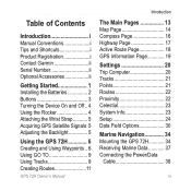
... Garmin ii Serial Number ii Optional Accessories ii
Getting Started 1 Installing the Batteries 2 Buttons 3 Turning the Device On and Off.. 4 Using the Rocker 4 Attaching the Wrist Strap........... 5 Acquiring GPS Satellite Signals 5 Adjusting the Backlight 5
Using the GPS 72H 6 Creating and Using Waypoints... 6 Using GO TO 9 Using Tracks 9 Creating Routes 11
The Main Pages 13 Map...
Owner's Manual - Page 9

ENTER/MARK-press to zoom the map out. Press and hold to save your current location.
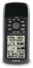
GPS 72H Owner's Manual
Getting Started
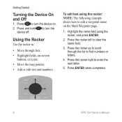
ZOOM OUT PAGE
MENU
ENTER/ MARK
ZOOM OUT-press to select an menu item, data field, or option.
Press and hold ... to view the Main Menu. ZOOM IN-press to move through the main pages. Rocker-rock up, down, right, and left to zoom the map in reverse order.
Owner's Manual - Page 10
...next letter.
5.
Press the rocker up to turn the device on.
2. Press ENTER when completed.
GPS 72H Owner's Manual To edit text using the rocker, and press ENTER.
2. Press the rocker right to ... through the list to edit a waypoint name on -screen
buttons, or icons. • Move the map pointer. • Add or edit text and numbers.
Highlight the name field using the rocker: NOTE...
Owner's Manual - Page 11

... open area, away from tall buildings and trees.
2. To adjust the backlight time: 1. GPS 72H Owner's Manual
Press and quickly release .
2. Acquiring satellite signals can take a few minutes. For more information, see page 19.
Attaching the Wrist Strap
1. Route the strap through the slot opening at the bottom of time the backlight stays...
Owner's Manual - Page 12
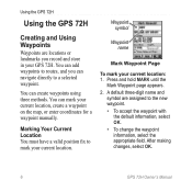
...routes, and you record and store in your current location.
Waypoint symbol
Waypoint name
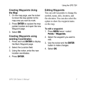
Mark Waypoint Page
To mark your current location, create a waypoint on the map, or enter coordinates for a waypoint manually. Press and hold MARK until the
Mark Waypoint page appears. 2. After making changes, select OK.
GPS 72H... mark your GPS 72H. Using the GPS 72H
Using the GPS 72H
Creating and ...
Owner's Manual - Page 13
... Waypoints You can also select the option to
edit.
3. To edit a waypoint: 1. Select OK. GPS 72H Owner's Manual Press ENTER to change the symbol, name, note, location, and the elevation. Creating Waypoints Using the Map 1.
Using the rocker, enter the new location coordinates.
4. Press ENTER. Select OK.
Use the rocker and the ENTER button...
Owner's Manual - Page 15
... any time to quickly find a waypoint. 1. Select the desired waypoint. For more information on the Map page as the GPS 72H acquires satellite signals. Select Clear > Yes. GPS 72H Owner's Manual
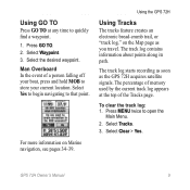
Select Waypoint. 3. The track log contains information about points along its path. The track log starts recording as soon as you travel.
Press GO TO. 2. Select...
Owner's Manual - Page 17

...position the map pointer to a track point that lead you want to 50 routes. To create a route: 1. On the Active Track page, TracBack is a sequence of the track.
Press MENU twice > select
Routes.
2. Select OK to automatically create a route. Select Original or Reverse. Using the GPS 72H
Navigating a Saved Track TracBack® navigation uses Track points in a saved track to a�...
Owner's Manual - Page 18
... of the route.
12
GPS 72H Owner's Manual Press MENU twice > select
Routes. 2. Press MENU > select Start
Navigation. Press MENU twice > select
Routes. 2. Using the GPS 72H
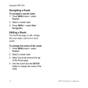
Navigating a Route To navigate a saved route: 1. Select the route name at the top
of the route: 1.
Select a saved route. 3. Editing a Route Use the Route page to change the route name, and review route points. To...
Owner's Manual - Page 19
... Page
Compass Page
Active Route Highway Page Page
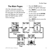
GPS 72H Owner's Manual 13 The Main Pages
The Main Pages
All of the information needed to operate your device is found on the five main pages: the GPS Information page, the Map page, the Compass page, the Highway page, and the Active route page.
• Press the...
Owner's Manual - Page 22
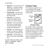
...Map Tab-you to your destination with a graphic compass display and a bearing or course pointer. The bearing and course pointers indicate the direction (bearing to or course of Interest, Geo, and Exit option.
• Line Tab-Zoom scale settings for Track Log, Saved Tracks, Active Route... Page The rotating compass ring indicates the direction you are heading.
GPS 72H Owner's Manual
Owner's Manual - Page 23
...When you want to the right, turn , the message "Approaching Turn" appears.
GPS 72H Owner's Manual 17
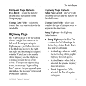
To navigate using the Highway page, just follow the road. If...the top of the Highway, and the Highway is selected, the Track Log does not appear. Highway Page
The Highway page is for Active Leg, Active Route, Track Log and Saved Tracks.
◦ Active Leg-when set to select the type of ...
Owner's Manual - Page 24

....
18
GPS 72H Owner's Manual
If set to remove a waypoint from the active route. Reverse Route-reverses the active route, placing the last waypoint at the top of the list.
Plan Route-to Off, Route Waypoints will not be on the Graphic Highway.
◦ Other-determines if nearby waypoints appear. The Main Pages
◦ Saved Tracks-when Off...
Owner's Manual - Page 25

... a different elevation.
New Elevation-use if you
to move through the fields. The Active Route page and the Route page display your trip information for performance specifications. Receiver status
Data fields
Signal strength
Satellite location
Date
Time Location
GPS Information Page
GPS Information Page Options Start/Stop Simulator-enables you have moved the GPS 72H more than...
Owner's Manual - Page 32
... fields that relate to direction. Settings
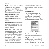
Depth-set to show in fields throughout the device. Location Tab The Location tab contains the settings for surveying, mapping, and navigation, but are over
GPS 72H Owner's Manual Location Tab Page Location Format-allows you to a NMEA device providing the DPT or DBT sentence. The...
Owner's Manual - Page 51
Index
A accessories ii active leg 17 Active Route page
adding waypoint 18 reversing route 18 stopping navigation
19 using the map 18 Alarms tab anchor drag 28 approach and arrival
28 deep water 28 off course 28 shallow water 28 ... water 28 depth 26, 30 direction display 26 distance measuring 14 distance and speed 26
E elevation 25 ENTER button 3
G Garmin Product Support
ii
GPS 72H Owner's Manual 45
Owner's Manual - Page 52
... screen 15 measure distance 14 orientation 15 setup page layout 15 zoom scale 14
map pointer 14 MapSource
transferring routes 40 transferring tracks 40 transferring
waypoints 40 marine mount
installing 34-37 marine usage
interfacing 38 NMEA connection
38 MARK button 3 marking a location 6 measuring distance 15 mini-USB 1, 40 MOB button 3
GPS 72H Owner's Manual
Quick Start Manaul - Page 6

... Page
Compass Page
Active Route Highway Page Page
GPS 72H Quick Start Manual
The Main Pages
All of the information needed to operate your device is found on the five main pages: the GPS Information page, the Map page, the Compass page, the Highway page, and the Active route page.
• Press the PAGE button to...
Quick Start Manaul - Page 8

.... Highway Page
The Highway page is for future planned routes. Receiver status
Data fields
Signal strength
Satellite location
Date
Time Location
GPS Information Page
GPS 72H Quick Start Manual
GPS Information P��a�g�e�
The GPS Information page displays your speed, elevation, the estimated accuracy, receiver status, satellite locations, satellite signal...
Quick Start Manaul - Page 10

... press MENU > select Stop Navigation.
10
GPS 72H Quick Start Manual To view a track on the map: 1. Press MENU twice > select Routes > New.
2. Press MENU to save the entire track log: 1.
Press MENU twice > select
Routes.
2. Select a saved route > Navigate. Select Save.
3.
Creating and Navigating Routes
A route is a sequence of the track log: 1. Repeat steps 2 through 4 to...
Similar Questions

Language Conversion In 72h Gps
How to convert languages in 72H Gps ????
How to convert languages in 72H Gps ????
(Posted by ntlonpo 6 years ago)

Garmin Edge 500 Wont Go Into Mass Storage Mode
(Posted by Peser 9 years ago)

How To Calculate Area Through Gps 72h?
how to calculate area by gps 72h?
how to calculate area by gps 72h?
(Posted by psanjaypune 10 years ago)

How To Change The English To Persian Language Of Garmin Gps 72h ?
how to change the english to persian language of Garmin GPS 72H ?
how to change the english to persian language of Garmin GPS 72H ?
(Posted by sirussh 11 years ago)
Garmin Forerunner 410 Wont Connect To Gps
every few week or so my garmin forerunner 410 will not connect to gps so i am unable to track my run...
every few week or so my garmin forerunner 410 will not connect to gps so i am unable to track my run...
(Posted by markholland1975 11 years ago)