Declaration of Conformity
Page 1
... EN 61000-4-4 Electromagnetic Compatibility - Electrostatic Discharge Immunity Test EN 61000-4-3 Electromagnetic Compatibility - Authorised Representative: GARMIN (Europe) Ltd, Liberty House, Hounsdown Business Park Southampton, Hampshire, SO40 9RB, U.K. Electrical Fast ...GARMIN International & 1200 E. 151st Street Olathe, Kansas 66062 U.S.A GARMIN Corporation No.68, Jangshu 2nd Rd., Shijr, Taipei County, TAIWAN, R.O.C. Emissions EN 60950-1:2001+A11:2004 Safety of Equipment: Information Technology Equipment (Global Positioning System Receiver) Model Number(s): GPSMAP 696...
... EN 61000-4-4 Electromagnetic Compatibility - Electrostatic Discharge Immunity Test EN 61000-4-3 Electromagnetic Compatibility - Authorised Representative: GARMIN (Europe) Ltd, Liberty House, Hounsdown Business Park Southampton, Hampshire, SO40 9RB, U.K. Electrical Fast ...GARMIN International & 1200 E. 151st Street Olathe, Kansas 66062 U.S.A GARMIN Corporation No.68, Jangshu 2nd Rd., Shijr, Taipei County, TAIWAN, R.O.C. Emissions EN 60950-1:2001+A11:2004 Safety of Equipment: Information Technology Equipment (Global Positioning System Receiver) Model Number(s): GPSMAP 696...

Owner's Manual
Page 6
... altitude should be considered as an aid to be used as a primary reference for any outdated database do so entirely at their own risk. Garmin GPSMAP 695/696 Owner's Manual 190-00919-00 Rev. Do not attempt to be relied upon the use this unit for terrain avoidance and does not relieve the...
... altitude should be considered as an aid to be used as a primary reference for any outdated database do so entirely at their own risk. Garmin GPSMAP 695/696 Owner's Manual 190-00919-00 Rev. Do not attempt to be relied upon the use this unit for terrain avoidance and does not relieve the...

Owner's Manual
Page 7
...subject to see and avoid other aircraft. WARNING: For safety reasons, GPSMAP 695/696 operational procedures must be significantly older than the indicated weather product age. Portions of the Garmin GPSMAP 695/696 utilize GPS as with in data link weather products may not accurately depict... current weather conditions. G Garmin GPSMAP 695/696 Owner's Manual Due to time delays inherent in gathering and processing...
...subject to see and avoid other aircraft. WARNING: For safety reasons, GPSMAP 695/696 operational procedures must be significantly older than the indicated weather product age. Portions of the Garmin GPSMAP 695/696 utilize GPS as with in data link weather products may not accurately depict... current weather conditions. G Garmin GPSMAP 695/696 Owner's Manual Due to time delays inherent in gathering and processing...

Owner's Manual
Page 8
...contained within this document, including screen images of the GPSMAP 695/696 display, are only examples. Depictions of equipment may not reflect the most current GPSMAP 695/696 and aviation databases. Garmin GPSMAP 695/696 Owner's Manual 190-00919-00 Rev. Thoroughly practice basic... navigation sources, including the information from the GPSMAP 695/696 to occur without a fault indication shown by an authorized Garmin service center. NOTE: The Garmin GPSMAP 695/696 has a very high degree of the GPSMAP 695/696 User's Manual documentation and the Pilot's Operating...
...contained within this document, including screen images of the GPSMAP 695/696 display, are only examples. Depictions of equipment may not reflect the most current GPSMAP 695/696 and aviation databases. Garmin GPSMAP 695/696 Owner's Manual 190-00919-00 Rev. Thoroughly practice basic... navigation sources, including the information from the GPSMAP 695/696 to occur without a fault indication shown by an authorized Garmin service center. NOTE: The Garmin GPSMAP 695/696 has a very high degree of the GPSMAP 695/696 User's Manual documentation and the Pilot's Operating...

Owner's Manual
Page 9
G Garmin GPSMAP 695/696 Owner's Manual This notice is being provided in the terrain and obstacle databases comes from government agencies. Warnings, Cautions & Notes NOTE: This device complies with California's Proposition 65. Operation is installed. 190-00919-00 Rev. Garmin accurately processes and cross-validates the ... TFR information. If you have any interference received, including interference that may cause the display to our web site at www.garmin.com/prop65. NOTE: The data contained in accordance with part 15 of polarized eyewear may cause undesired operation. NOTE: Do...
G Garmin GPSMAP 695/696 Owner's Manual This notice is being provided in the terrain and obstacle databases comes from government agencies. Warnings, Cautions & Notes NOTE: This device complies with California's Proposition 65. Operation is installed. 190-00919-00 Rev. Garmin accurately processes and cross-validates the ... TFR information. If you have any interference received, including interference that may cause the display to our web site at www.garmin.com/prop65. NOTE: The data contained in accordance with part 15 of polarized eyewear may cause undesired operation. NOTE: Do...

Owner's Manual
Page 10
... on airport review page. • Added suggested indicated altitude on Airport Waypoint page. Change Summary Rev Date D November, 2008 E March, 2012 Production Release. RR-10 Garmin GPSMAP 695/696 Owner's Manual 190-00919-00 Rev.
... on airport review page. • Added suggested indicated altitude on Airport Waypoint page. Change Summary Rev Date D November, 2008 E March, 2012 Production Release. RR-10 Garmin GPSMAP 695/696 Owner's Manual 190-00919-00 Rev.

Owner's Manual
Page 11
... display current climb gradient in percent or altitude gain per nautical mile. • Added runway number labels to runway extension lines on maps and charts. G Garmin GPSMAP 695/696 Owner's Manual RR-11 System Software Version 4.70-4.80 changes: • Added display setup option to show/hide aircraft position on map. • Added...
... display current climb gradient in percent or altitude gain per nautical mile. • Added runway number labels to runway extension lines on maps and charts. G Garmin GPSMAP 695/696 Owner's Manual RR-11 System Software Version 4.70-4.80 changes: • Added display setup option to show/hide aircraft position on map. • Added...

Owner's Manual
Page 12
Rev Date F July, 2012 Description System Software Version 4.90-5.00 changes: • Correct Disclaimer page database expiration date information • Correct missing 'Mark' waypoint operation (695 units only) System Software Version 5.00-6.00 changes: • Added GDL 39 support G August, 2012 System Software Version 6.00-6.20 changes: • Added TargetTrend™ • Added GDL 39 Serial Pass-Through RR-12 Garmin GPSMAP 695/696 Owner's Manual 190-00919-00 Rev. G
Rev Date F July, 2012 Description System Software Version 4.90-5.00 changes: • Correct Disclaimer page database expiration date information • Correct missing 'Mark' waypoint operation (695 units only) System Software Version 5.00-6.00 changes: • Added GDL 39 support G August, 2012 System Software Version 6.00-6.20 changes: • Added TargetTrend™ • Added GDL 39 Serial Pass-Through RR-12 Garmin GPSMAP 695/696 Owner's Manual 190-00919-00 Rev. G

Owner's Manual
Page 13
G Garmin GPSMAP 695/696 Owner's Manual i Table of Contents SECTION 1 OVERVIEW...1 1.1 Unit Overview...1 Battery Care and Charging...2 Turning the Unit On/Off...4 GPS Receiver Status...6 1.2 GPSMAP 695/696 Controls 8 1.3 Accessing System Functionality 10 Menus...10 Data Entry...11 Pages...13 Main Page Softkeys...18 Flight Planning Softkeys...23 Nearest Page Softkeys...24 1.4 System ...
G Garmin GPSMAP 695/696 Owner's Manual i Table of Contents SECTION 1 OVERVIEW...1 1.1 Unit Overview...1 Battery Care and Charging...2 Turning the Unit On/Off...4 GPS Receiver Status...6 1.2 GPSMAP 695/696 Controls 8 1.3 Accessing System Functionality 10 Menus...10 Data Entry...11 Pages...13 Main Page Softkeys...18 Flight Planning Softkeys...23 Nearest Page Softkeys...24 1.4 System ...

Owner's Manual
Page 14
... Selecting an Approach...97 Activating Vectors-to-Final 100 3.6 Trip Planning...101 SECTION 4 HAZARD AVOIDANCE 103 4.1 Weather Information...103 SiriusXM Weather (696 only 104 Data Link weather (FIS-B 124 4.2 Terrain...141 Terrain Information...142 Obstacle Information...142 Terrain and Obstacle Color Code 143 ii Garmin GPSMAP 695/696 Owner's Manual 190-00919-00 Rev. G
... Selecting an Approach...97 Activating Vectors-to-Final 100 3.6 Trip Planning...101 SECTION 4 HAZARD AVOIDANCE 103 4.1 Weather Information...103 SiriusXM Weather (696 only 104 Data Link weather (FIS-B 124 4.2 Terrain...141 Terrain Information...142 Obstacle Information...142 Terrain and Obstacle Color Code 143 ii Garmin GPSMAP 695/696 Owner's Manual 190-00919-00 Rev. G
Owner's Manual
Page 15
... Symbol...178 FliteCharts Cycle Number and Expiration Date 179 5.4 Airport Directory Data 180 5.5 SiriusXM Radio Entertainment (GPSMAP 696 182 Activating SiriusXM Satellite Radio Services 182 Using SiriusXM Radio...183 5.6 Electronic Checklists...188 5.7 Flight Data Logging...GPSMAP 695/696 Databases 198 Updating GPSMAP 695/696 Databases 202 Exporting Track Logs and User Waypoints 205 Importing/Exporting Flight Plans 205 Installation & Interfacing Information 207 Connecting the Power/Data Cable 207 Connecting to a Garmin VHF Comm Radio 208 190-00919-00 Rev. G Garmin GPSMAP 695/696...
... Symbol...178 FliteCharts Cycle Number and Expiration Date 179 5.4 Airport Directory Data 180 5.5 SiriusXM Radio Entertainment (GPSMAP 696 182 Activating SiriusXM Satellite Radio Services 182 Using SiriusXM Radio...183 5.6 Electronic Checklists...188 5.7 Flight Data Logging...GPSMAP 695/696 Databases 198 Updating GPSMAP 695/696 Databases 202 Exporting Track Logs and User Waypoints 205 Importing/Exporting Flight Plans 205 Installation & Interfacing Information 207 Connecting the Power/Data Cable 207 Connecting to a Garmin VHF Comm Radio 208 190-00919-00 Rev. G Garmin GPSMAP 695/696...
Owner's Manual
Page 16
...Connecting to a Computer 209 Information about USB Drivers 210 Using xImage for Customized Waypoint Symbols 210 Connecting the GXM 40 Antenna (GPSMAP 696 210 Interfacing...211 Connecting to a GTX 330 Mode S Transponder 213 Connecting to a GDL 39...214 Using an external GPS Antenna... Garmin...255 Software License Agreement 255 Limited Warranty...255 AOPA Airport Directory Notice 256 AC-U-KWIK LICENSE AGREEMENT 256 Weather Data Warranty...257 SiriusXM Satellite Radio Service Agreement 258 FCC Compliance...258 Industry Canada Compliance 258 Index...Index-1 iv Garmin GPSMAP 695/696 Owner...
...Connecting to a Computer 209 Information about USB Drivers 210 Using xImage for Customized Waypoint Symbols 210 Connecting the GXM 40 Antenna (GPSMAP 696 210 Interfacing...211 Connecting to a GTX 330 Mode S Transponder 213 Connecting to a GDL 39...214 Using an external GPS Antenna... Garmin...255 Software License Agreement 255 Limited Warranty...255 AOPA Airport Directory Notice 256 AC-U-KWIK LICENSE AGREEMENT 256 Weather Data Warranty...257 SiriusXM Satellite Radio Service Agreement 258 FCC Compliance...258 Industry Canada Compliance 258 Index...Index-1 iv Garmin GPSMAP 695/696 Owner...
Owner's Manual
Page 17
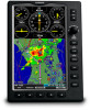
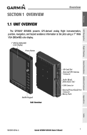
Overview GPS Navigation Flight Planning Hazard Avoidance Additional Features SECTION 1 OVERVIEW Overview 1.1 UNIT OVERVIEW The GPSMAP 695/696 presents GPS-derived analog flight instrumentation, position, navigation, and hazard avoidance information to the pilot using a 7" Wide VGA (800x480) color display. 7" WVGA (800x480) Color Display ... Card Slot External GPS Antenna Connector Audio (Headphones/Line Out) USB Connector External Power/Serial Port Connector Battery Pack Appendices Index 190-00919-00 Rev. G Garmin GPSMAP 695/696 Owner's Manual 1
Overview GPS Navigation Flight Planning Hazard Avoidance Additional Features SECTION 1 OVERVIEW Overview 1.1 UNIT OVERVIEW The GPSMAP 695/696 presents GPS-derived analog flight instrumentation, position, navigation, and hazard avoidance information to the pilot using a 7" Wide VGA (800x480) color display. 7" WVGA (800x480) Color Display ... Card Slot External GPS Antenna Connector Audio (Headphones/Line Out) USB Connector External Power/Serial Port Connector Battery Pack Appendices Index 190-00919-00 Rev. G Garmin GPSMAP 695/696 Owner's Manual 1
Owner's Manual
Page 18
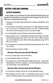
... aircraft on a hot day. To purchase a replacement battery, see your local waste disposal department to properly recycle/dispose of the unit. • Only replace with a Garmin Nickel Metal Hydride battery pack. To prevent damage, remove the unit from children. Using another battery presents a risk of the following temperature range: -68°... leave the unit exposed to a heat source or in a high temperature location, such as a waste electronics treatment facility, to have the battery removed and recycled. 2 Garmin GPSMAP 695/696 Owner's Manual 190-00919-00 Rev.
... aircraft on a hot day. To purchase a replacement battery, see your local waste disposal department to properly recycle/dispose of the unit. • Only replace with a Garmin Nickel Metal Hydride battery pack. To prevent damage, remove the unit from children. Using another battery presents a risk of the following temperature range: -68°... leave the unit exposed to a heat source or in a high temperature location, such as a waste electronics treatment facility, to have the battery removed and recycled. 2 Garmin GPSMAP 695/696 Owner's Manual 190-00919-00 Rev.
Owner's Manual
Page 19
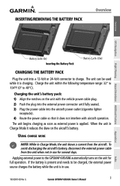
...within the following temperature range: 32° to 104°F (0° to charge. When the unit in use for full operation. G Garmin GPSMAP 695/696 Owner's Manual 3 Appendices Index The unit begins charging as soon as external power is charging. Applying external power to be used while it ...3) Plug the power cable into a 12-Volt or 24-Volt connector to 40°C). If the battery is present and needs to the GPSMAP 695/696 automatically turns on the aircraft's battery. Charging the unit's battery pack: 1) Align the notches on the unit with aircraft operation. Using charge...
...within the following temperature range: 32° to 104°F (0° to charge. When the unit in use for full operation. G Garmin GPSMAP 695/696 Owner's Manual 3 Appendices Index The unit begins charging as soon as external power is charging. Applying external power to be used while it ...3) Plug the power cable into a 12-Volt or 24-Volt connector to 40°C). If the battery is present and needs to the GPSMAP 695/696 automatically turns on the aircraft's battery. Charging the unit's battery pack: 1) Align the notches on the unit with aircraft operation. Using charge...

Owner's Manual
Page 20
.... A momentary press of completely turning off . Connect the unit to "find itself" anywhere in the world. 4 Garmin GPSMAP 695/696 Owner's Manual 190-00919-00 Rev. G Additional Features Hazard Avoidance Flight Planning Appendices Index Adjusting Backlighting on Power up . The... GPSMAP 695/696 retains the backlighting settings between power cycles. To ensure proper initialization, the GPSMAP 695/696 is turned on or off , the unit now goes into Charge Mode. Press and...
.... A momentary press of completely turning off . Connect the unit to "find itself" anywhere in the world. 4 Garmin GPSMAP 695/696 Owner's Manual 190-00919-00 Rev. G Additional Features Hazard Avoidance Flight Planning Appendices Index Adjusting Backlighting on Power up . The... GPSMAP 695/696 retains the backlighting settings between power cycles. To ensure proper initialization, the GPSMAP 695/696 is turned on or off , the unit now goes into Charge Mode. Press and...

Owner's Manual
Page 21
... Planning Hazard Avoidance Additional Features Appendices Database Initialization After acknowledgement of the database information, the pilot is prompted to acknowledge a data link weather advisory. G Garmin GPSMAP 695/696 Owner's Manual 5 Index When this information has been reviewed for currency (to ensure that no databases have expired), the pilot is prompted to continue. Overview...
... Planning Hazard Avoidance Additional Features Appendices Database Initialization After acknowledgement of the database information, the pilot is prompted to acknowledge a data link weather advisory. G Garmin GPSMAP 695/696 Owner's Manual 5 Index When this information has been reviewed for currency (to ensure that no databases have expired), the pilot is prompted to continue. Overview...

Owner's Manual
Page 22
... 3D fix Constellation Diagram PRN Number 45° Above Horizon Horizon Receiver Status Signal Strength Bar PRN Number GPS Status (Info Page) Appendices Index 6 Garmin GPSMAP 695/696 Owner's Manual 190-00919-00 Rev. Overview GPS Navigation Additional Features Hazard Avoidance Flight Planning Overview GPS RECEIVER STATUS The receiver status field on the...
... 3D fix Constellation Diagram PRN Number 45° Above Horizon Horizon Receiver Status Signal Strength Bar PRN Number GPS Status (Info Page) Appendices Index 6 Garmin GPSMAP 695/696 Owner's Manual 190-00919-00 Rev. Overview GPS Navigation Additional Features Hazard Avoidance Flight Planning Overview GPS RECEIVER STATUS The receiver status field on the...

Owner's Manual
Page 23
... the constellation diagram represents the horizon, the inner circle represents 45° above the horizon, and the center point shows the position directly overhead. G Garmin GPSMAP 695/696 Owner's Manual 7 Gray bar-Receiver has collected the necessary data and the satellite signal can be helpful in troubleshooting weak (or missing) signal levels due...
... the constellation diagram represents the horizon, the inner circle represents 45° above the horizon, and the center point shows the position directly overhead. G Garmin GPSMAP 695/696 Owner's Manual 7 Gray bar-Receiver has collected the necessary data and the satellite signal can be helpful in troubleshooting weak (or missing) signal levels due...

Owner's Manual
Page 24
Overview GPS Navigation Overview 1.2 GPSMAP 695/696 CONTROLS The GPSMAP 695/696 controls have been designed to simplify operation of the system and minimize workload and the time required to access sophisticated functionality. 1 2 3 4 5 6 7 8 9 Additional Features Hazard Avoidance ... change the selected value within the highlighted field Move the FMS Joystick to highlight fields or move the map pointer when interacting with the page Garmin GPSMAP 695/696 Owner's Manual 190-00919-00 Rev. G Index
Overview GPS Navigation Overview 1.2 GPSMAP 695/696 CONTROLS The GPSMAP 695/696 controls have been designed to simplify operation of the system and minimize workload and the time required to access sophisticated functionality. 1 2 3 4 5 6 7 8 9 Additional Features Hazard Avoidance ... change the selected value within the highlighted field Move the FMS Joystick to highlight fields or move the map pointer when interacting with the page Garmin GPSMAP 695/696 Owner's Manual 190-00919-00 Rev. G Index


