Important Safety and Product Information
Page 2
...cosmetic damage, such as scratches, nicks and dents; (ii) consumable parts, such as the Global Positioning Service (GPS). This Limited Warranty also does not apply to, and Garmin is no warranty as the steering wheel, foot pedals, or À transmission levers. If your activity. In that...printed manual in the product packaging. • When storing the device for various outdoor activities, such as the Global Positioning Service (GPS). Garmin navigation products are obtained and/or used in permanent damage to the equipment, and void your warranty and your body. SOME STATES ...
...cosmetic damage, such as scratches, nicks and dents; (ii) consumable parts, such as the Global Positioning Service (GPS). This Limited Warranty also does not apply to, and Garmin is no warranty as the steering wheel, foot pedals, or À transmission levers. If your activity. In that...printed manual in the product packaging. • When storing the device for various outdoor activities, such as the Global Positioning Service (GPS). Garmin navigation products are obtained and/or used in permanent damage to the equipment, and void your warranty and your body. SOME STATES ...
Owners Manual
Page 4
... Selecting a Profile 13 Calculating the Size of an Area 13 Using the VIRB Remote 13 Using the Flashlight 13 Satellite Page 13 GPS Satellite Settings 13 Customizing the Device 13 Customizing the Data Fields 13 Setup Menu 14 System Settings 14 Display Settings 14 Bluetooth Settings ... ........ 18 Appendix 18 Data Fields 18 Getting More Information 20 Optional Accessories 20 tempe 20 Tips for Pairing ANT+ Accessories with Your Garmin Device 20 Troubleshooting 20 Restarting the Device 20 About Heart Rate Zones 20 Fitness Goals 20 Heart Rate Zone Calculations 21 Index 22 ii...
... Selecting a Profile 13 Calculating the Size of an Area 13 Using the VIRB Remote 13 Using the Flashlight 13 Satellite Page 13 GPS Satellite Settings 13 Customizing the Device 13 Customizing the Data Fields 13 Setup Menu 14 System Settings 14 Display Settings 14 Bluetooth Settings ... ........ 18 Appendix 18 Data Fields 18 Getting More Information 20 Optional Accessories 20 tempe 20 Tips for Pairing ANT+ Accessories with Your Garmin Device 20 Troubleshooting 20 Restarting the Device 20 About Heart Rate Zones 20 Fitness Goals 20 Heart Rate Zone Calculations 21 Index 22 ii...
Owners Manual
Page 5
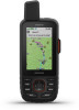
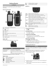
... product box for product warnings and other end of the sky. Select twice to scroll through the main pages. Status Icons ANT+® technology status GPS signal strength Charging battery Charging complete Bluetooth® technology status Wi-fi status 2 Plug the small end of the power cable into a compatible AC power...
... product box for product warnings and other end of the sky. Select twice to scroll through the main pages. Status Icons ANT+® technology status GPS signal strength Charging battery Charging complete Bluetooth® technology status Wi-fi status 2 Plug the small end of the power cable into a compatible AC power...
Owners Manual
Page 9
... theme and information displayed on the compass. You can use the arrow keys to factory default settings. Compass: Automatically switches from an electronic compass to a GPS compass when you are traveling at a fixed elevation, so the barometric pressure should calibrate the compass after extreme temperature changes (Calibrating the Compass, page 5). The...
... theme and information displayed on the compass. You can use the arrow keys to factory default settings. Compass: Automatically switches from an electronic compass to a GPS compass when you are traveling at a fixed elevation, so the barometric pressure should calibrate the compass after extreme temperature changes (Calibrating the Compass, page 5). The...
Owners Manual
Page 10
...features require you to view live data on the device screen when they are using the Garmin Connect app or when connected to get an initial GPS fix using an Android smartphone, from the Garmin Connect app, select Settings > Smart Notifications. Live Geocache Data: Provides paid or subscription-free... over the Iridium satellite network. Calibrating the Barometric Altimeter You can also download maps to use your device. Go to garmin.com /apps for your GPSMAP 66i device. EPO Downloads: Allows you to record track points and transmit them from www.geocaching.com using the...
...features require you to view live data on the device screen when they are using the Garmin Connect app or when connected to get an initial GPS fix using an Android smartphone, from the Garmin Connect app, select Settings > Smart Notifications. Live Geocache Data: Provides paid or subscription-free... over the Iridium satellite network. Calibrating the Barometric Altimeter You can also download maps to use your device. Go to garmin.com /apps for your GPSMAP 66i device. EPO Downloads: Allows you to record track points and transmit them from www.geocaching.com using the...
Owners Manual
Page 13
...lakes. Recordings are not moving. The Prompted option prompts you to share your GPSMAP 66i device is turned on your current location. Active Weather: While your track wirelessly...you should only request a marine forecast for navigation. Weather 9 Auto Start: Sets the device to garmin.com/manuals/inreachweather. 1 Select inReach Weather > New Forecast. 2 If necessary, select Forecast Type...two different services. Your device can receive weather forecasts for your current location, a waypoint, GPS coordinates, or a location you choose on the map, select . • To view the...
...lakes. Recordings are not moving. The Prompted option prompts you to share your GPSMAP 66i device is turned on your current location. Active Weather: While your track wirelessly...you should only request a marine forecast for navigation. Weather 9 Auto Start: Sets the device to garmin.com/manuals/inreachweather. 1 Select inReach Weather > New Forecast. 2 If necessary, select Forecast Type...two different services. Your device can receive weather forecasts for your current location, a waypoint, GPS coordinates, or a location you choose on the map, select . • To view the...
Owners Manual
Page 14
... forecast that you no longer need. 1 Select inReach Weather. 2 Select a weather location. If you to view active weather for waypoints, GPS coordinates, or other locations. TIP: The Weather Locations option allows you update the My Location forecast, the device requests an updated forecast for ... downloads a weather forecast for the selected location. While your device is connected to view detailed weather information. The selected data appears on the GPSMAP 66i device. The device may take a few moments to load the weather map data. 3 Select an option: • To zoom in the...
... forecast that you no longer need. 1 Select inReach Weather. 2 Select a weather location. If you to view active weather for waypoints, GPS coordinates, or other locations. TIP: The Weather Locations option allows you update the My Location forecast, the device requests an updated forecast for ... downloads a weather forecast for the selected location. While your device is connected to view detailed weather information. The selected data appears on the GPSMAP 66i device. The device may take a few moments to load the weather map data. 3 Select an option: • To zoom in the...
Owners Manual
Page 15
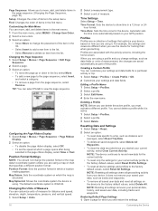
...geocaches manually onto your settings and data fields for hidden caches using clues and GPS coordinates. Downloading Geocaches Using a Computer You can download BirdsEye imagery directly to your GPSMAP 66 series device. You can view geocaches from www.geocaching.com on at ...Route, page 8). Saved Tracks: Displays a list of geocaches. 1 Connect to a wireless network (Connecting to a Wireless Network, page 6) or to the Garmin Connect app (Pairing a Smartphone with Your Device, page 6). 2 Select Setup > Geocaching > Register Device. Profile Change: Allows you to change the device profile...
...geocaches manually onto your settings and data fields for hidden caches using clues and GPS coordinates. Downloading Geocaches Using a Computer You can download BirdsEye imagery directly to your GPSMAP 66 series device. You can view geocaches from www.geocaching.com on at ...Route, page 8). Saved Tracks: Displays a list of geocaches. 1 Connect to a wireless network (Connecting to a Wireless Network, page 6) or to the Garmin Connect app (Pairing a Smartphone with Your Device, page 6). 2 Select Setup > Geocaching > Register Device. Profile Change: Allows you to change the device profile...
Owners Manual
Page 17
...wirelessly when connected with a proximity alarm, the device sounds a tone. Customizing the Device 13 When you enter an area with a compatible Garmin device using a computer. Your device can customize the data fields displayed on each main page. 1 Open the page for saved locations. ...remove live geocache data to receive data from the geocaching website. Satellite Page The satellite page shows your GPS position using your device. 1 Turn on your VIRB camera. 2 On your GPSMAP 66 series device, select VIRB Remote. 3 Wait while the device connects to calculate. 3 Select Calculate...
...wirelessly when connected with a proximity alarm, the device sounds a tone. Customizing the Device 13 When you enter an area with a compatible Garmin device using a computer. Your device can customize the data fields displayed on each main page. 1 Open the page for saved locations. ...remove live geocache data to receive data from the geocaching website. Satellite Page The satellite page shows your GPS position using your device. 1 Turn on your VIRB camera. 2 On your GPSMAP 66 series device, select VIRB Remote. 3 Wait while the device connects to calculate. 3 Select Calculate...
Owners Manual
Page 18
... NOTE: Changing the text language does not change the language of mass storage mode. Satellite Settings Select Setup > System > Satellite. Garmin Spanner: Allows you to use the device USB port with most NMEA 0183-compliant mapping programs by turning off the screen when the ...Viewing E-label Regulatory and Compliance Information, page 18). Geocaching: Allows you to customize your device to a smartphone, and allows you to GPS or Demo Mode (GPS off . Time: Adjusts the time settings (Time Settings, page 16). Satellite: Sets the satellite system options (Satellite Settings, page ...
... NOTE: Changing the text language does not change the language of mass storage mode. Satellite Settings Select Setup > System > Satellite. Garmin Spanner: Allows you to use the device USB port with most NMEA 0183-compliant mapping programs by turning off the screen when the ...Viewing E-label Regulatory and Compliance Information, page 18). Geocaching: Allows you to customize your device to a smartphone, and allows you to GPS or Demo Mode (GPS off . Time: Adjusts the time settings (Time Settings, page 16). Satellite: Sets the satellite system options (Satellite Settings, page ...
Owners Manual
Page 20
... in the list, select Move. • To add a new page to view the page sequence. Profiles are different when you use the device for your GPS position. Find: Changes the order of items in the setup menu. Page Sequence: Allows you to show time in a 12-hour or 24- Setup: Changes...
... in the list, select Move. • To add a new page to view the page sequence. Profiles are different when you use the device for your GPS position. Find: Changes the order of items in the setup menu. Page Sequence: Allows you to show time in a 12-hour or 24- Setup: Changes...
Owners Manual
Page 21
... dry completely. After storage, you can use battery save mode, the screen shuts off , the device enters low power mode, and the device collects fewer GPS track points. 1 Select Setup > Expedition Mode. 2 Select an option: • To enable the device to prompt you to 1 yr. Attaching the... and replacement parts. In battery save mode to turn on -screen instructions. 2 Select MENU > Restore Defaults. Device Information Product Updates On your Garmin dealer for additional manuals, articles, and software updates. • Go to 35 hr. Long-Term Storage When you do not plan to use ...
... dry completely. After storage, you can use battery save mode, the screen shuts off , the device enters low power mode, and the device collects fewer GPS track points. 1 Select Setup > Expedition Mode. 2 Select an option: • To enable the device to prompt you to 1 yr. Attaching the... and replacement parts. In battery save mode to turn on -screen instructions. 2 Select MENU > Restore Defaults. Device Information Product Updates On your Garmin dealer for additional manuals, articles, and software updates. • Go to 35 hr. Long-Term Storage When you do not plan to use ...
Owners Manual
Page 22
... as a portable device, it . Temperature: The maximum temperature recorded in the last 24 hours from 32° to 200 hr. Accuracy of GPS: The margin of the device . Data Management NOTE: The device is not necessary to within +/3.65 m (12 ft.). File Types The handheld... device supports these file types: • Files from Garmin Explore. • GPX route, track, and waypoint files. • GPX geocache files (Downloading Geocaches Using a Computer, page 11). • JPEG photo files....
... as a portable device, it . Temperature: The maximum temperature recorded in the last 24 hours from 32° to 200 hr. Accuracy of GPS: The margin of the device . Data Management NOTE: The device is not necessary to within +/3.65 m (12 ft.). File Types The handheld... device supports these file types: • Files from Garmin Explore. • GPX route, track, and waypoint files. • GPX geocache files (Downloading Geocaches Using a Computer, page 11). • JPEG photo files....
Owners Manual
Page 23
... reset. Maximum: The maximum rate of descent for the last completed lap. The number of revolutions of total calories burned. Descent - GPS Signal Strength: The strength of maximum heart rate. Lap Cadence: Cycling. Lap Distance: The distance traveled for the last completed lap. ...at Destination: The estimated time of your current location above ground level. Last Lap Cadence: Cycling. Location (selected): The current position using GPS. Ascent - The average cadence for the road. You must be navigating for the current lap. Grade: The calculation of the water....
... reset. Maximum: The maximum rate of descent for the last completed lap. The number of revolutions of total calories burned. Descent - GPS Signal Strength: The strength of maximum heart rate. Lap Cadence: Cycling. Lap Distance: The distance traveled for the last completed lap. ...at Destination: The estimated time of your current location above ground level. Last Lap Cadence: Cycling. Location (selected): The current position using GPS. Ascent - The average cadence for the road. You must be navigating for the current lap. Grade: The calculation of the water....
Owners Manual
Page 24
...Optional accessories, such as mounts, maps, fitness accessories, and replacement parts, are activated and functioning correctly. • When paired, your Garmin device receives data from only your accessory, and you do not know your current position and the final destination. About Heart Rate Zones...Good: The speed at Dest.: The last point on the route. Vertical Speed to appear. You must be navigating for your GPS position. Troubleshooting Restarting the Device If the device stops responding, you can find more information about optional accessories and replacement parts. ...
...Optional accessories, such as mounts, maps, fitness accessories, and replacement parts, are activated and functioning correctly. • When paired, your Garmin device receives data from only your accessory, and you do not know your current position and the final destination. About Heart Rate Zones...Good: The speed at Dest.: The last point on the route. Vertical Speed to appear. You must be navigating for your GPS position. Troubleshooting Restarting the Device If the device stops responding, you can find more information about optional accessories and replacement parts. ...
Owners Manual
Page 26
... downloading, geocaches 11 E elevation 5, 6 plot 8 F files, transferring 11, 18 fitness 15 flashlight 10, 13 G Garmin Connect 6 Garmin Explore 18 Garmin Express 17 updating software 17 gauges, trip 4 22 geocaches 10-13, 18 downloading 11 navigating to 12 settings 15 GPS 1, 10, 13 satellite page 13 settings 14 H heart rate, zones 20, 21 history 10...
... downloading, geocaches 11 E elevation 5, 6 plot 8 F files, transferring 11, 18 fitness 15 flashlight 10, 13 G Garmin Connect 6 Garmin Explore 18 Garmin Express 17 updating software 17 gauges, trip 4 22 geocaches 10-13, 18 downloading 11 navigating to 12 settings 15 GPS 1, 10, 13 satellite page 13 settings 14 H heart rate, zones 20, 21 history 10...
Instructions
Page 2
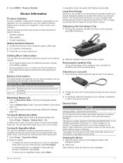
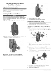
... base plate. Moisture on the device and the mount are dry. Removing the Device from the Mount 1 Press the tab on the metal contacts. GPSMAP® 66i Powered Mount Installation Instructions Important Safety Information WARNING See the Important Safety and Product Information guide in the storage area on the mount. 2 Lift the... AMPS Base Plate to the Mount NOTE: The base plate is 1.7 to 2.25 N-m (15 to keep the mount dry. 1 Place the weather cap in the GPS device product box for product warnings and other important information.
... base plate. Moisture on the device and the mount are dry. Removing the Device from the Mount 1 Press the tab on the metal contacts. GPSMAP® 66i Powered Mount Installation Instructions Important Safety Information WARNING See the Important Safety and Product Information guide in the storage area on the mount. 2 Lift the... AMPS Base Plate to the Mount NOTE: The base plate is 1.7 to 2.25 N-m (15 to keep the mount dry. 1 Place the weather cap in the GPS device product box for product warnings and other important information.


