Important Safety and Product Information
Page 2
...or an experienced radio/TV technician for various purposes, such as a clothes dryer. Battery Notices • Do not immerse the device or batteries in water or other associated taxes and charges. Garmin does not assume any Global Navigation Satellite System (GNSS), such as these resources, ...If you seek warranty service outside of the original country of purchase, Garmin cannot guarantee that the structure, organization, and code of the Software, for any country. Battery Warnings A lithium-ion battery can have the proper gear and supplies for warranty verification. You further ...
...or an experienced radio/TV technician for various purposes, such as a clothes dryer. Battery Notices • Do not immerse the device or batteries in water or other associated taxes and charges. Garmin does not assume any Global Navigation Satellite System (GNSS), such as these resources, ...If you seek warranty service outside of the original country of purchase, Garmin cannot guarantee that the structure, organization, and code of the Software, for any country. Battery Warnings A lithium-ion battery can have the proper gear and supplies for warranty verification. You further ...
Owners Manual
Page 4
... Profiles 16 Resetting Data and Settings 16 Device Information 17 Product Updates 17 Setting Up Garmin Express 17 Getting More Information 17 Battery Information 17 Maximizing Battery Life 17 Turning On Battery Save Mode 17 Turning On Expedition Mode 17 Long-Term Storage 17 Attaching the Carabiner ...18 Appendix 18 Data Fields 18 Getting More Information 20 Optional Accessories 20 tempe 20 Tips for Pairing ANT+ Accessories with Your Garmin Device 20 Troubleshooting 20 Restarting the Device 20 About Heart Rate Zones 20 Fitness Goals 20 Heart Rate Zone Calculations 21 Index ...
... Profiles 16 Resetting Data and Settings 16 Device Information 17 Product Updates 17 Setting Up Garmin Express 17 Getting More Information 17 Battery Information 17 Maximizing Battery Life 17 Turning On Battery Save Mode 17 Turning On Expedition Mode 17 Long-Term Storage 17 Attaching the Carabiner ...18 Appendix 18 Data Fields 18 Getting More Information 20 Optional Accessories 20 tempe 20 Tips for Pairing ANT+ Accessories with Your Garmin Device 20 Troubleshooting 20 Restarting the Device 20 About Heart Rate Zones 20 Fitness Goals 20 Heart Rate Zone Calculations 21 Index ...
Owners Manual
Page 5
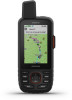
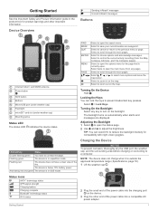
... menu options and move the map cursor. Select , , , or to choose options and acknowledge messages. Status Icons ANT+® technology status GPS signal strength Charging battery Charging complete Bluetooth® technology status Wi-fi status 2 Plug the small end of the power cable into a compatible AC power adapter. LED Activity Status... Backlight 1 Select to open the status page. 2 Use and to open the search menu. NOTE: The device does not charge when it is below 10% battery power. Getting Started 1
... menu options and move the map cursor. Select , , , or to choose options and acknowledge messages. Status Icons ANT+® technology status GPS signal strength Charging battery Charging complete Bluetooth® technology status Wi-fi status 2 Plug the small end of the power cable into a compatible AC power adapter. LED Activity Status... Backlight 1 Select to open the status page. 2 Use and to open the search menu. NOTE: The device does not charge when it is below 10% battery power. Getting Started 1
Owners Manual
Page 6
...The device also checks for messages, sending a message, or sending a track point. Ensure you send a message, your GPSMAP 66i device, you created at the time of a satellite at explore.garmin.com. Sending a Text Message 1 From the Messages page, select New Message. 2 Select an option: • ...To start with the antenna pointed toward the sky. 4 Plug the AC power adapter into a low power, battery charging mode, and the battery gauge appears. 3 ...
...The device also checks for messages, sending a message, or sending a track point. Ensure you send a message, your GPSMAP 66i device, you created at the time of a satellite at explore.garmin.com. Sending a Text Message 1 From the Messages page, select New Message. 2 Select an option: • ...To start with the antenna pointed toward the sky. 4 Plug the AC power adapter into a low power, battery charging mode, and the battery gauge appears. 3 ...
Owners Manual
Page 7
... controls. Your reply lets the emergency response service know that does not support viewing maps or is outside of your situation. To conserve battery power after it is sent to the emergency response service every minute. Canceling an SOS Rescue If you no longer need assistance, you ...a new message. For example, if your recipient has an older model cell phone that you are capable of interacting with a custom message using the Garmin Explore app. Including Location Coordinates in a Message If you are sending a message to a recipient who may not have internet access, you can include...
... controls. Your reply lets the emergency response service know that does not support viewing maps or is outside of your situation. To conserve battery power after it is sent to the emergency response service every minute. Canceling an SOS Rescue If you no longer need assistance, you ...a new message. For example, if your recipient has an older model cell phone that you are capable of interacting with a custom message using the Garmin Explore app. Including Location Coordinates in a Message If you are sending a message to a recipient who may not have internet access, you can include...
Owners Manual
Page 17
...the flashlight can send and receive data wirelessly when connected with a compatible Garmin device using the Garmin AutoLocate® feature. SOS Emergency strobe. GPS Satellite Settings Select Satellite... Before you can remove live geocache data to your VIRB camera. You can remove your GPSMAP 66 series device, select VIRB Remote. 3 Wait while the device connects to show only...manually loaded on . Select Setup > Geocaching > Geocaching Live > Unregister Device. Your device can reduce battery life. Calculating the Size of an Area 1 Select Area Calculation > Start. 2 Walk around the ...
...the flashlight can send and receive data wirelessly when connected with a compatible Garmin device using the Garmin AutoLocate® feature. SOS Emergency strobe. GPS Satellite Settings Select Satellite... Before you can remove live geocache data to your VIRB camera. You can remove your GPSMAP 66 series device, select VIRB Remote. 3 Wait while the device connects to show only...manually loaded on . Select Setup > Geocaching > Geocaching Live > Unregister Device. Your device can reduce battery life. Calculating the Size of an Area 1 Select Area Calculation > Start. 2 Walk around the ...
Owners Manual
Page 18
... the units of day, select Mode > Auto. • To use a light background, select Mode > Day. • To use a Garmin proprietary format to use Wide Area Augmentation System/European Geostationary Navigation Overlay Service (WAAS/EGNOS) data. About: Displays device information, such as key tones... and track data with your device (Wireless Sensors, page 15). Sensors: Pairs wireless sensors with a computer. Battery Save: Saves the battery power and prolongs the battery life by creating a virtual serial port. Review Text Size: Changes the size of the text on the time ...
... the units of day, select Mode > Auto. • To use a light background, select Mode > Day. • To use a Garmin proprietary format to use Wide Area Augmentation System/European Geostationary Navigation Overlay Service (WAAS/EGNOS) data. About: Displays device information, such as key tones... and track data with your device (Wireless Sensors, page 15). Sensors: Pairs wireless sensors with a computer. Battery Save: Saves the battery power and prolongs the battery life by creating a virtual serial port. Review Text Size: Changes the size of the text on the time ...
Owners Manual
Page 21
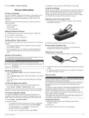
.... You should fully recharge the device before you can install the Garmin Explore app to tether it . Battery Information The actual battery life depends on expedition mode after exposure to prolong the battery life. Battery Life Mode Up to extreme temperatures can damage plastic components and finishes... mounting spine of inactivity, select Auto. • To never turn on the Garmin website. • Go to support.garmin.com for information about optional accessories and replacement parts. In battery save mode to turn on expedition mode, select Never. 2 Slide the carabiner clip...
.... You should fully recharge the device before you can install the Garmin Explore app to tether it . Battery Information The actual battery life depends on expedition mode after exposure to prolong the battery life. Battery Life Mode Up to extreme temperatures can damage plastic components and finishes... mounting spine of inactivity, select Auto. • To never turn on the Garmin website. • Go to support.garmin.com for information about optional accessories and replacement parts. In battery save mode to turn on expedition mode, select Never. 2 Slide the carabiner clip...
Owners Manual
Page 22
...the current track or activity. On Mac computers, the device and memory card appear as mounted volumes on Mac computers. in lithium-ion battery Battery life Up to 32 GB, for your computer. in .) Wireless frequency/protocol 2.4 GHz @ 14.9 dBm nominal Viewing E-label Regulatory ...is not compatible with multiple network drives may not display device drives properly. File Types The handheld device supports these file types: • Files from Garmin Explore. • GPX route, track, and waypoint files. • GPX geocache files (Downloading Geocaches Using a Computer, page 11). •...
...the current track or activity. On Mac computers, the device and memory card appear as mounted volumes on Mac computers. in lithium-ion battery Battery life Up to 32 GB, for your computer. in .) Wireless frequency/protocol 2.4 GHz @ 14.9 dBm nominal Viewing E-label Regulatory ...is not compatible with multiple network drives may not display device drives properly. File Types The handheld device supports these file types: • Files from Garmin Explore. • GPX route, track, and waypoint files. • GPX geocache files (Downloading Geocaches Using a Computer, page 11). •...
Owners Manual
Page 23
... Lap Ascent: The vertical distance of ascent for this data to appear. Last Lap Speed: The average speed for the last completed lap. Battery Level: The remaining battery power. You must be navigating for this data to appear. Lap Ascent: The vertical distance of ascent for the last completed lap. Lap Speed...
... Lap Ascent: The vertical distance of ascent for this data to appear. Last Lap Speed: The average speed for the last completed lap. Battery Level: The remaining battery power. You must be navigating for this data to appear. Lap Ascent: The vertical distance of ascent for the last completed lap. Lap Speed...
Owners Manual
Page 26
...13 tones 15 altimeter 5 calibrating 6 ANT+ sensors 15 pairing 20 applications 6, 7 area calculation 10, 13 Auto Lap 15 B backlight 1, 14, 17 battery 17 charging 1, 2 level 1 life 17 maximizing 14, 17 storage 17 BirdsEye imagery 10 Bluetooth sensors 15 Bluetooth technology 1, 6, 14 brightness 1 C ...display settings 14 downloading, geocaches 11 E elevation 5, 6 plot 8 F files, transferring 11, 18 fitness 15 flashlight 10, 13 G Garmin Connect 6 Garmin Explore 18 Garmin Express 17 updating software 17 gauges, trip 4 22 geocaches 10-13, 18 downloading 11 navigating to 12 settings 15 GPS 1, 10, ...
...13 tones 15 altimeter 5 calibrating 6 ANT+ sensors 15 pairing 20 applications 6, 7 area calculation 10, 13 Auto Lap 15 B backlight 1, 14, 17 battery 17 charging 1, 2 level 1 life 17 maximizing 14, 17 storage 17 BirdsEye imagery 10 Bluetooth sensors 15 Bluetooth technology 1, 6, 14 brightness 1 C ...display settings 14 downloading, geocaches 11 E elevation 5, 6 plot 8 F files, transferring 11, 18 fitness 15 flashlight 10, 13 G Garmin Connect 6 Garmin Explore 18 Garmin Express 17 updating software 17 gauges, trip 4 22 geocaches 10-13, 18 downloading 11 navigating to 12 settings 15 GPS 1, 10, ...


