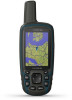
Owners Manual
Page 3
...GPSMAP Device Overview (Camera 1 Battery Information 1 Maximizing Battery Life 1 Turning On Battery Save Mode 1 Long-Term Storage 1 Installing a NiMH Battery Pack 1 Charging the Battery Pack 2 Installing AA Batteries 2 Turning On the Device 2 Keys 2 Acquiring Satellite Signals 2 Using the Main Pages 2 Opening the Main Menu 2 Map 2 Changing the Map Orientation 2 Measuring Distance on the Map 3 Map... 6 Calculating the Size of an Area 6 Satellite Page 6 GPS Satellite Settings 6 Garmin Adventures 7 Sending Files to BaseCamp 7 Creating an Adventure 7 Starting an Adventure 7 ...
...GPSMAP Device Overview (Camera 1 Battery Information 1 Maximizing Battery Life 1 Turning On Battery Save Mode 1 Long-Term Storage 1 Installing a NiMH Battery Pack 1 Charging the Battery Pack 2 Installing AA Batteries 2 Turning On the Device 2 Keys 2 Acquiring Satellite Signals 2 Using the Main Pages 2 Opening the Main Menu 2 Map 2 Changing the Map Orientation 2 Measuring Distance on the Map 3 Map... 6 Calculating the Size of an Area 6 Satellite Page 6 GPS Satellite Settings 6 Garmin Adventures 7 Sending Files to BaseCamp 7 Creating an Adventure 7 Starting an Adventure 7 ...
Owners Manual
Page 5
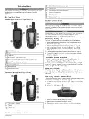
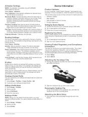
...MCX connector for GPS antenna (under weather cap)1 microSD® card slot (under batteries) Battery compartment Mounting spine Battery cover D-ring GPSMAP Device Overview (Camera) Mini-USB port (under weather cap) Camera lens microSD card slot (under batteries) Battery compartment Mounting spine Battery ... backlight timeout (Display Settings, page 9). • Use battery save mode (Turning On Battery Save Mode, page 1). • Decrease the map drawing speed (Map Settings, page 3). • Turn off when the backlight times out. Stored data is not included on the screen, and you do several...
...MCX connector for GPS antenna (under weather cap)1 microSD® card slot (under batteries) Battery compartment Mounting spine Battery cover D-ring GPSMAP Device Overview (Camera) Mini-USB port (under weather cap) Camera lens microSD card slot (under batteries) Battery compartment Mounting spine Battery ... backlight timeout (Display Settings, page 9). • Use battery save mode (Turning On Battery Save Mode, page 1). • Decrease the map drawing speed (Map Settings, page 3). • Turn off when the backlight times out. Stored data is not included on the screen, and you do several...
Owners Manual
Page 6
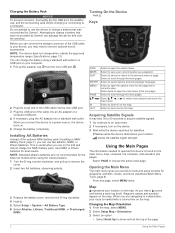
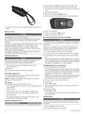
...plot pages. Select to select options and acknowledge messages. Map represents your location. This is found on the map. Select to zoom in on the map. Select to tools and setup screens for the page that was not provided by Garmin®. Opening the Main Menu The main menu gives you...thoroughly dry the USB port, the weather cap, and the surrounding area before charging or connecting to charge a battery that was not provided by Garmin can charge the battery using the camera feature. 1 Turn the D-ring counter-clockwise, and pull up the weather cap from any page, select...
...plot pages. Select to select options and acknowledge messages. Map represents your location. This is found on the map. Select to zoom in on the map. Select to tools and setup screens for the page that was not provided by Garmin®. Opening the Main Menu The main menu gives you...thoroughly dry the USB port, the weather cap, and the surrounding area before charging or connecting to charge a battery that was not provided by Garmin can charge the battery using the camera feature. 1 Turn the D-ring counter-clockwise, and pull up the weather cap from any page, select...
Owners Manual
Page 7
...course deviation indicator (CDI) provides the indication of the numbers shown on your map. Change Dashboard: Changes the theme and information displayed on the map. Advanced Map Settings Select Setup > Map > Advanced Map Setup. The map items will appear. Trip Computer The trip computer displays your current speed, ...at a higher rate of speed for a period of the electronic compass, you are . The device has a 3-axis electronic compass (GPSMAP 64s/sc/st/sx/csx devices only). When points toward the top of your relationship to the course line leading to the object. ...
...course deviation indicator (CDI) provides the indication of the numbers shown on your map. Change Dashboard: Changes the theme and information displayed on the map. Advanced Map Settings Select Setup > Map > Advanced Map Setup. The map items will appear. Trip Computer The trip computer displays your current speed, ...at a higher rate of speed for a period of the electronic compass, you are . The device has a 3-axis electronic compass (GPSMAP 64s/sc/st/sx/csx devices only). When points toward the top of your relationship to the course line leading to the object. ...
Owners Manual
Page 8
...1 Select Route Planner. 2 Select a route. 3 Select Edit Route. 4 Select a point. 5 Select an option: • To view the point on the map, select Review. • To change the order of waypoints or locations that point. Elevation Plot NOTE: The elevation plot is inserted before the point you.... Calibrating the Barometric Altimeter You can add details about that leads you to a location where the elevation or barometric pressure is available only with GPSMAP 64s/sc/st/sx/csx devices. NOTE: The barometric altimeter is known. 2 Select PAGE > Elevation Plot > MENU > Calibrate Altimeter. 3...
...1 Select Route Planner. 2 Select a route. 3 Select Edit Route. 4 Select a point. 5 Select an option: • To view the point on the map, select Review. • To change the order of waypoints or locations that point. Elevation Plot NOTE: The elevation plot is inserted before the point you.... Calibrating the Barometric Altimeter You can add details about that leads you to a location where the elevation or barometric pressure is available only with GPSMAP 64s/sc/st/sx/csx devices. NOTE: The barometric altimeter is known. 2 Select PAGE > Elevation Plot > MENU > Calibrate Altimeter. 3...
Owners Manual
Page 9
...color of your route to navigate the route in reverse. 1 Select Route Planner. 2 Select a route. 3 Select Reverse Route. Purchasing Additional Maps 1 Go to your device product page at a variable rate to create an optimum representation of your path. You can view photos by selecting ... Saved Track 1 Select FIND > Tracks. 2 Select a saved track. 3 Select Go. Auto records the tracks at www.garmin.com. 2 Click the Maps tab. 3 Follow the on the map. Recording points more frequently creates a more-detailed track, but fills the track log faster. Viewing the Current Track 1 Select ...
...color of your route to navigate the route in reverse. 1 Select Route Planner. 2 Select a route. 3 Select Reverse Route. Purchasing Additional Maps 1 Go to your device product page at a variable rate to create an optimum representation of your path. You can view photos by selecting ... Saved Track 1 Select FIND > Tracks. 2 Select a saved track. 3 Select Go. Auto records the tracks at www.garmin.com. 2 Click the Maps tab. 3 Follow the on the map. Recording points more frequently creates a more-detailed track, but fills the track log faster. Viewing the Current Track 1 Select ...
Owners Manual
Page 10
...select Done. Setting a Proximity Alarm Proximity alarms alert you when you enter an area with GPSMAP 64s/sc/st/sx/csx devices. You can reduce battery life. Before you can share... specified range of a Photo 1 Select Photo Viewer. 2 Select a photo. 3 Select MENU > View Map. Logging the Attempt After you have attempted to find and download geocaches to send data. 3 Follow the ...your results. NOTE: This feature is a treasure hunting activity in . 5 Follow the instructions at www.garmin.com. You can reduce the brightness or flash frequency to extend the life of the batteries. 1 Select...
...select Done. Setting a Proximity Alarm Proximity alarms alert you when you enter an area with GPSMAP 64s/sc/st/sx/csx devices. You can reduce battery life. Before you can share... specified range of a Photo 1 Select Photo Viewer. 2 Select a photo. 3 Select MENU > View Map. Logging the Attempt After you have attempted to find and download geocaches to send data. 3 Follow the ...your results. NOTE: This feature is a treasure hunting activity in . 5 Follow the instructions at www.garmin.com. You can reduce the brightness or flash frequency to extend the life of the batteries. 1 Select...
Owners Manual
Page 11
... are only available when Use Demo Mode is available only with GPSMAP 64s/sc/st/sx/csx devices. AutoLocate Position: Calculates your compatible smartphone. See your operating system documentation to learn how to map the drive. 3 Open the Garmin or memory card drive or volume. 4 Select an option: ...adventure. Use Demo Mode: Allows you must download BaseCamp to your computer and transfer a track from your device to your GPSMAP 64s/sc/st/sx/csx device. Garmin Adventures You can use the VIRB Remote function, you to follow your smartphone. Bluetooth Connected Features Your...
... are only available when Use Demo Mode is available only with GPSMAP 64s/sc/st/sx/csx devices. AutoLocate Position: Calculates your compatible smartphone. See your operating system documentation to learn how to map the drive. 3 Open the Garmin or memory card drive or volume. 4 Select an option: ...adventure. Use Demo Mode: Allows you must download BaseCamp to your computer and transfer a track from your device to your GPSMAP 64s/sc/st/sx/csx device. Garmin Adventures You can use the VIRB Remote function, you to follow your smartphone. Bluetooth Connected Features Your...
Owners Manual
Page 12
... water. Location (selected): The current position using the device, you will change in latitude and longitude regardless of your current location above ground level (if maps contain sufficient elevation information). Course: The direction from your starting location to the final destination. If you are received. Elevation Above Ground: The altitude of...
... water. Location (selected): The current position using the device, you will change in latitude and longitude regardless of your current location above ground level (if maps contain sufficient elevation information). Course: The direction from your starting location to the final destination. If you are received. Elevation Above Ground: The altitude of...
Owners Manual
Page 13
... to use a Garmin proprietary format to accept Differential Global Positioning System (DGPS) information from a device supplying Radio Technical Commission for this data to appear. RTCM: Allows the device to exchange waypoint, route, and track data with most NMEA 0183-compliant mapping programs by creating ... destination along a route. AA Battery Type: Allows you to appear. Your device can reduce battery life more quickly than using . Garmin Spanner: Allows you are closing on the route to change the language of the next waypoint or turn. Customizing the Device 9 Speed ...
... to use a Garmin proprietary format to accept Differential Global Positioning System (DGPS) information from a device supplying Radio Technical Commission for this data to appear. RTCM: Allows the device to exchange waypoint, route, and track data with most NMEA 0183-compliant mapping programs by creating ... destination along a route. AA Battery Type: Allows you to appear. Your device can reduce battery life more quickly than using . Garmin Spanner: Allows you are closing on the route to change the language of the next waypoint or turn. Customizing the Device 9 Speed ...
Owners Manual
Page 14
... for the device. TIP: You can adjust the backlight brightness to adjust the backlight level. Automatic sets the time zone automatically based on the map. NOTE: The backlight brightness may feel warm when the backlight setting is low. 1 Select . 2 Use the slider to maximize the battery life... a specified drift distance while anchored, when you are off course by a specified distance, and when you are more readable and so the map reflects the drawing scheme of measure. Marine Alarm Setup: Sets alarms for optimal use of screen backlighting can move, add, and delete items ...
... for the device. TIP: You can adjust the backlight brightness to adjust the backlight level. Automatic sets the time zone automatically based on the map. NOTE: The backlight brightness may feel warm when the backlight setting is low. 1 Select . 2 Use the slider to maximize the battery life... a specified drift distance while anchored, when you are off course by a specified distance, and when you are more readable and so the map reflects the drawing scheme of measure. Marine Alarm Setup: Sets alarms for optimal use of screen backlighting can move, add, and delete items ...
Owners Manual
Page 15
...are doing . On your computer, install Garmin Express™ (www.garmin.com /express). This provides easy access to these services for Garmin devices: • Software updates • Map updates • Data uploads to Garmin Connect • Product registration Setting Up Garmin Express 1 Connect the device to your ...must activate a different profile. Altimeter Settings NOTE: The altimeter is available only for some activities. This setting is available only with GPSMAP 64s/sc/st/sx/csx devices. For example, the settings and views are using a profile and you are using a USB ...
...are doing . On your computer, install Garmin Express™ (www.garmin.com /express). This provides easy access to these services for Garmin devices: • Software updates • Map updates • Data uploads to Garmin Connect • Product registration Setting Up Garmin Express 1 Connect the device to your ...must activate a different profile. Altimeter Settings NOTE: The altimeter is available only for some activities. This setting is available only with GPSMAP 64s/sc/st/sx/csx devices. For example, the settings and views are using a profile and you are using a USB ...
Owners Manual
Page 16
...fresh water after exposure to www.garmin.com/products/poiloader. Go to chlorinated or salt water environments. Your device memory contains important system files that can withstand accidental immersion in 1 meter of water for additional storage or pre-loaded maps. 1 Turn the D-ring counter-... mounted volumes. Do not store the device where prolonged exposure to extreme temperatures can occur, because it . After submersion, be deleted. 1 Open the Garmin drive or volume. 2 If necessary, open the file browser. 3 Select a file. 4 Select Edit > Copy. 5 Open the portable device, ...
...fresh water after exposure to www.garmin.com/products/poiloader. Go to chlorinated or salt water environments. Your device memory contains important system files that can withstand accidental immersion in 1 meter of water for additional storage or pre-loaded maps. 1 Turn the D-ring counter-... mounted volumes. Do not store the device where prolonged exposure to extreme temperatures can occur, because it . After submersion, be deleted. 1 Open the Garmin drive or volume. 2 If necessary, open the file browser. 3 Select a file. 4 Select Edit > Copy. 5 Open the portable device, ...
Owners Manual
Page 17
..., provides a consistent source of the ANT+ accessory. • After you must empty the Trash folder to support.garmin.com for up to 1 m for help and information, such as mounts, maps, fitness accessories, and replacement parts, are activated and functioning correctly. • When paired, your... Garmin device receives data from only your Garmin dealer. IEC 60529 IPX71 From -20° to 45°C (from -4° ...
..., provides a consistent source of the ANT+ accessory. • After you must empty the Trash folder to support.garmin.com for up to 1 m for help and information, such as mounts, maps, fitness accessories, and replacement parts, are activated and functioning correctly. • When paired, your... Garmin device receives data from only your Garmin dealer. IEC 60529 IPX71 From -20° to 45°C (from -4° ...
Owners Manual
Page 18
... fields 8 deleting, all user data 12 device, registration 11 downloading, geocaches 6 E elevation 4 F files, transferring 6, 12 flashlight 6 G Garmin Connect 7 Garmin Express 11 updating software 11 geocaches 6, 12 downloading 6 GLONASS 9 GPS 6, 9 satellite page 6 settings 9 H HomePort 12 hunting and fishing times... 8 K keys 1, 2 L locations editing 4 14 saving 4 M main menu 2 customizing 10 maps 5 measuring distances 3 navigating 2 ...
... fields 8 deleting, all user data 12 device, registration 11 downloading, geocaches 6 E elevation 4 F files, transferring 6, 12 flashlight 6 G Garmin Connect 7 Garmin Express 11 updating software 11 geocaches 6, 12 downloading 6 GLONASS 9 GPS 6, 9 satellite page 6 settings 9 H HomePort 12 hunting and fishing times... 8 K keys 1, 2 L locations editing 4 14 saving 4 M main menu 2 customizing 10 maps 5 measuring distances 3 navigating 2 ...

Important Safety and Product Information
Page 2
...purchase or to have the proper gear and supplies for your Garmin® device accepts street maps and suggests routes that follow roads, follow the instructions on , the user is 90 days or to the end of Garmin, or (vi) damage to a product that has been connected... cause interference, and (2) this equipment does cause harmful interference to radio or 2 television reception, which source code is prohibitively expensive. Map Data Information Garmin uses a combination of any user-serviceable parts. If during the warranty period you can be available due to use the software embedded ...
...purchase or to have the proper gear and supplies for your Garmin® device accepts street maps and suggests routes that follow roads, follow the instructions on , the user is 90 days or to the end of Garmin, or (vi) damage to a product that has been connected... cause interference, and (2) this equipment does cause harmful interference to radio or 2 television reception, which source code is prohibitively expensive. Map Data Information Garmin uses a combination of any user-serviceable parts. If during the warranty period you can be available due to use the software embedded ...


