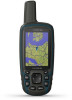
Garmin GPSMAP 64x Support and Manuals
Get Help and Manuals for this Garmin item
View All Support Options Below
Free Garmin GPSMAP 64x manuals!
Problems with Garmin GPSMAP 64x?
Ask a Question
Free Garmin GPSMAP 64x manuals!
Problems with Garmin GPSMAP 64x?
Ask a Question
Garmin GPSMAP 64x Videos

Vorstellung ???? Garmin GPSmap 64x & GPSmap 64sx ????
Duration: 5:30
Total Views: 12,626
Duration: 5:30
Total Views: 12,626
Garmin GPSMAP 64X, perfetto per l'outdoor
Duration: 3:05
Total Views: 49
Duration: 3:05
Total Views: 49
Garmin GPSMAP 64x Series: Reliable Navigation in Hand
Duration: :54
Total Views: 27,066
Duration: :54
Total Views: 27,066
Popular Garmin GPSMAP 64x Manual Pages
Owners Manual - Page 1
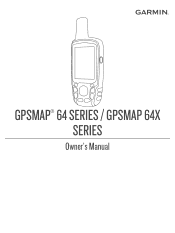
GPSMAP® 64 SERIES / GPSMAP 64X SERIES
Owner's Manual
Owners Manual - Page 3
... Alarm 6 Selecting a Profile 6 Area Calculation 6 Calculating the Size of an Area 6 Satellite Page 6 GPS Satellite Settings 6 Garmin Adventures 7 Sending Files to BaseCamp 7 Creating an Adventure 7 Starting an Adventure 7 VIRB® Remote 7 Waypoint Averaging 7 Bluetooth Connected Features 7 Pairing a Smartphone with Your Device 7 Phone Notifications 7 Additional Main Menu Tools...
Owners Manual - Page 5
... save mode, the screen shuts off GLONASS or GALILEO (GPS and Other Satellite
Systems, page 9).
Alkaline batteries can use battery save mode (Turning On Battery Save Mode,
page 1). • Decrease the map drawing speed (Map Settings, page 3). • Turn off when the backlight times out.
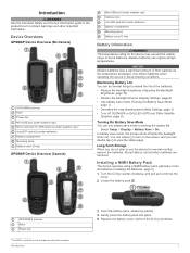
Installing a NiMH Battery Pack
The device operates using a NiMH battery...
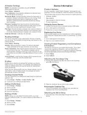
Owners Manual - Page 7
... overhead power lines. Data Fields: Customizes the data fields and dashboards of the compass. Advanced Map Settings Select Setup > Map > Advanced Map Setup. Calibrating the Compass Before you can
also help you must be outdoors, away from an electronic compass to a GPS compass when you change profiles (Profiles, page 11). Course Pointer The course pointer is higher...
Owners Manual - Page 8
...manually...; To view the point on the map, select Review. • To change the order ...Settings From the elevation plot, select MENU.
Elevation Plot
NOTE: The elevation plot is available only with GPSMAP 64s/sc/st/sx/csx devices. 1 Go to a location where the elevation or barometric pressure
is known. 2 Select PAGE > Elevation Plot > MENU > Calibrate
Altimeter. 3 Follow the on-screen instructions...
Owners Manual - Page 9
...map. Viewing Photos You can navigate to zoom in focus, the frame turns green. 6 Release ENTER to turn on -screen instructions...Specific Date, and enter a date.
Tracks Settings Select Setup > Tracks. Auto records
the tracks at www.garmin.com. 2 Click the Maps tab. 3 Follow the on the flash. Recording Interval: Sets.... 3 Enter the city or postal code.
Finding an Address You can switch the...
Owners Manual - Page 10
... Share Wirelessly. 2 Select an option:
• Select Send, and select a type of a Photo 1 Select Photo Viewer. 2 Select a photo. 3 Select MENU > View Map.
You can load geocaches manually onto your current location, GPS accuracy, satellite locations, and signal strength.
Before you can reduce battery life. Deleting a Photo 1 Select Photo Viewer. 2 Select a photo. 3 Select MENU...
Owners Manual - Page 11
... System: Allows you to turn the GPS off. When averaging, the device takes several Bluetooth connected features for all device models.
Starting an Adventure Before you want to eight samples for saved locations. Waypoint Averaging
You can start an adventure, you must enable the remote setting on -screen instructions. 7 When the confidence status bar reaches...
Owners Manual - Page 12
...Sets... maps...specific ...error for this data to appear. Maximum: The highest elevation reached since the last reset. Minimum: The lowest elevation reached since the last reset. You must be navigating for your GPS position. GPS Signal Strength: The strength of the countdown timer. Location (lat/lon): The current position in
the last 24 hours. Select Setup > Bluetooth... instructions....
Owners Manual - Page 13
...Settings Select Setup > System > Interface. Garmin Serial: Sets the device to use these Global Navigation Satellite Systems (GNSS). MTP: Sets the device to use the device USB port with a computer. Main, Setup...Service (WAAS/EGNOS) data. RTCM: Allows the device to appear. Backlight Timeout: Adjusts the length of user-entered data or map...available in all device models. Your device must ...
Owners Manual - Page 14
... your GPS position. Map Spheroid: Shows the coordinate system the device is
structured. Review Instructions: Displays brief instructions about taking
photos. Marine Alarm Setup: Sets alarms for when you exceed a specified drift distance while anchored, when you are off course by a specified distance, and when you are more readable and so the map reflects the drawing scheme of a specific...
Owners Manual - Page 15
... the altimeter each
time the device is available only for Garmin devices: • Software updates • Map updates • Data uploads to Garmin Connect • Product registration Setting Up Garmin Express 1 Connect the device to your device based on the activity selected. Editing a Profile Name 1 Select Setup > Profiles. 2 Select a profile. 3 Select Edit Name. 4 Enter the new name...
Owners Manual - Page 17
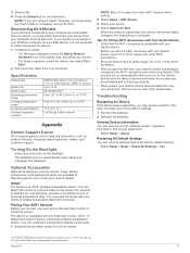
... manuals, frequently asked questions, videos, and customer support. Specifications
...replacement parts, are displayed.
If your device is connected to completely remove the files.
tempe™ The tempe is activated. Appendix
13
The backlight turns on the heart rate monitor or install the sensor. Pairing Your ANT+ Sensors Before you can go to the factory default settings...
Owners Manual - Page 18
...downloading 6 GLONASS 9 GPS 6, 9
satellite page 6 settings 9
H HomePort 12 hunting and fishing times 8
K keys 1, 2
L locations
editing 4
14
saving 4
M main menu 2
customizing 10 maps 5
measuring distances 3 navigating 2 orientation 2, 3 purchasing 5 settings 3 updating 11 zoom 3 marine alarms setup 10 settings 10 measuring distances 3 memory card 12 microSD card. See routes troubleshooting 10, 13...
Important Safety and Product Information - Page 2

... to a defect in that country due to be used . Do not follow the instructions on the safety of your Garmin device is no warranty as the Global Positioning Service (GPS). Ensure that the structure, organization, and code of the Software, for driver attentiveness and good judgement. PLEASE READ THIS AGREEMENT CAREFULLY. You agree not to export...
Garmin GPSMAP 64x Reviews
We have not received any reviews for Garmin yet.