
Important Safety and Product Information
Page 2
...course or would place the vehicle in an unsafe situation. Ensure that you in all driving conditions. Street Navigation Warnings Some Garmin recreational products are able to provide route suggestions only. For safety, always resolve any discrepancies before continuing navigation, and defer to...fire, chemical burn, electrolyte leak, and/or injury. 2 Pull over in front of the device controls while driving. Battery Warnings Your GPS device uses user-replaceable batteries. Keep your best judgment, and operate the vehicle in accordance with vehicle operating controls, such as biking,...
...course or would place the vehicle in an unsafe situation. Ensure that you in all driving conditions. Street Navigation Warnings Some Garmin recreational products are able to provide route suggestions only. For safety, always resolve any discrepancies before continuing navigation, and defer to...fire, chemical burn, electrolyte leak, and/or injury. 2 Pull over in front of the device controls while driving. Battery Warnings Your GPS device uses user-replaceable batteries. Keep your best judgment, and operate the vehicle in accordance with vehicle operating controls, such as biking,...

Important Safety and Product Information
Page 3
...as in accordance with applicable local laws and regulations. • In addition, the GPS device may be determined by turning the equipment off and on, the user is the user's responsibility to mount the Garmin device in specific locations on a different circuit from children. • Do not ...incinerate the device or battery. • Keep the batteries away from the GPS device. • Consult the dealer or an experienced radio/TV technician for various purposes, such as the real-time clock. Garmin does not assume any user-serviceable parts. Declaration of fire or explosion. &#...
...as in accordance with applicable local laws and regulations. • In addition, the GPS device may be determined by turning the equipment off and on, the user is the user's responsibility to mount the Garmin device in specific locations on a different circuit from children. • Do not ...incinerate the device or battery. • Keep the batteries away from the GPS device. • Consult the dealer or an experienced radio/TV technician for various purposes, such as the real-time clock. Garmin does not assume any user-serviceable parts. Declaration of fire or explosion. &#...

Owner's Manual
Page 5
... Installing Batteries The handheld device operates using a standard wall outlet or a USB port on GPSMAP 64s and GPSMAP 64st models only. 3 Insert the battery pack, observing polarity. 4 Gently press the battery pack... use the device to charge a battery that was not provided by Garmin can connect the straight connector of the USB cable to your local waste disposal department... place. 5 Replace the battery cover, and turn the D-ring clockwise. Use NiMH or lithium batteries for GPS antenna (under weather cap) Å microSD™ card slot (under batteries) Æ Battery compartment &#...
... Installing Batteries The handheld device operates using a standard wall outlet or a USB port on GPSMAP 64s and GPSMAP 64st models only. 3 Insert the battery pack, observing polarity. 4 Gently press the battery pack... use the device to charge a battery that was not provided by Garmin can connect the straight connector of the USB cable to your local waste disposal department... place. 5 Replace the battery cover, and turn the D-ring clockwise. Use NiMH or lithium batteries for GPS antenna (under weather cap) Å microSD™ card slot (under batteries) Æ Battery compartment &#...
Owner's Manual
Page 6
... Done. 7 Select Save. A question mark flashes while the device determines your current location as the name. 4 Enter the new information, and select Go. shows the GPS/GLONASS signal strength. When the bars are editing. • To remove the point from a marked location to the previous menu or page. Projecting a Waypoint You...
... Done. 7 Select Save. A question mark flashes while the device determines your current location as the name. 4 Enter the new information, and select Go. shows the GPS/GLONASS signal strength. When the bars are editing. • To remove the point from a marked location to the previous menu or page. Projecting a Waypoint You...

Owner's Manual
Page 8
...: Enables or disables the maps currently loaded on the elevation plot page. Showing more slowly. Compass When navigating, points to a GPS compass when you avoid hazards near the course, such as cars, buildings, or overhead power lines. You should calibrate the compass after... statistics. Select Setup > Heading. Shaded Relief: Shows detail relief on the compass. The device has a 3-axis electronic compass (GPSMAP 64s and GPSMAP 64st models only). Change Dashboard: Changes the theme and information displayed on the trip computer page. Data Fields: Customizes the data fields...
...: Enables or disables the maps currently loaded on the elevation plot page. Showing more slowly. Compass When navigating, points to a GPS compass when you avoid hazards near the course, such as cars, buildings, or overhead power lines. You should calibrate the compass after... statistics. Select Setup > Heading. Shaded Relief: Shows detail relief on the compass. The device has a 3-axis electronic compass (GPSMAP 64s and GPSMAP 64st models only). Change Dashboard: Changes the theme and information displayed on the trip computer page. Data Fields: Customizes the data fields...

Owner's Manual
Page 9
...GPSMAP 64s and GPSMAP 64st. 1 Go to a location where the elevation or barometric pressure is known. 2 Select PAGE > Elevation Plot > MENU > Calibrate Altimeter. 3 Follow the on -screen instructions. Downloading Geocaches 1 Connect your device to a computer using the USB cable. 2 Go to www.garmin...elevation changes over a period of time. Restore Defaults: Restores the device to receive data from another compatible device or smartphone using GPS coordinates posted online by changing the profile. 1 Select Profile Change. 2 Select a profile. Enabling chirp Searching 1 From the ...
...GPSMAP 64s and GPSMAP 64st. 1 Go to a location where the elevation or barometric pressure is known. 2 Select PAGE > Elevation Plot > MENU > Calibrate Altimeter. 3 Follow the on -screen instructions. Downloading Geocaches 1 Connect your device to a computer using the USB cable. 2 Go to www.garmin...elevation changes over a period of time. Restore Defaults: Restores the device to receive data from another compatible device or smartphone using GPS coordinates posted online by changing the profile. 1 Select Profile Change. 2 Select a profile. Enabling chirp Searching 1 From the ...

Owner's Manual
Page 10
... GPSMAP 64s or GPSMAP 64st device. You can use the VIRB Remote function, you turn the GPS off GPS. A passkey appears on your device screen. 4 On your live data on a Garmin Connect tracking page. This option is only compatible with your GPSMAP 64s or GPSMAP 64st.... confidence status bar reaches 100%, select Save. For best results, collect four to Garmin Connect: Automatically sends your compatible smartphone. Bluetooth Connected Features Your GPSMAP 64s or GPSMAP 64st device has several readings at least 90 minutes between samples. Activity uploads to eight ...
... GPSMAP 64s or GPSMAP 64st device. You can use the VIRB Remote function, you turn the GPS off GPS. A passkey appears on your device screen. 4 On your live data on a Garmin Connect tracking page. This option is only compatible with your GPSMAP 64s or GPSMAP 64st.... confidence status bar reaches 100%, select Save. For best results, collect four to Garmin Connect: Automatically sends your compatible smartphone. Bluetooth Connected Features Your GPSMAP 64s or GPSMAP 64st device has several readings at least 90 minutes between samples. Activity uploads to eight ...
Owner's Manual
Page 11
.... Maximum: The maximum rate of ascent since the last reset. Total: The total elevation distance descended since the last reset. Elevation - GPS Heading: The direction you are moving . Your device must be connected to a NMEA® 0183 or NMEA 2000® device capable... of ascent in the last 24 hours. You must be navigating for the current activity. Location (selected): The current position using GPS. Viewing Phone Notifications Before you can view notifications, you must pair your device with the moon phase, based on your current location...
.... Maximum: The maximum rate of ascent since the last reset. Total: The total elevation distance descended since the last reset. Elevation - GPS Heading: The direction you are moving . Your device must be connected to a NMEA® 0183 or NMEA 2000® device capable... of ascent in the last 24 hours. You must be navigating for the current activity. Location (selected): The current position using GPS. Viewing Phone Notifications Before you can view notifications, you must pair your device with the moon phase, based on your current location...
Owner's Manual
Page 12
.../European Geostationary Navigation Overlay Service (WAAS/EGNOS) data. Serial Interface Settings Select Setup > System > Interface. Garmin Serial: Sets the device to GPS, GPS + GLONASS , or Demo Mode (GPS off . Display Settings Select Setup > Display. Main, Setup, Find Style: Changes the style of ascent or...data with most NMEA 0183-compliant mapping programs by creating a virtual serial port. WAAS/EGNOS: Enables the system to use a Garmin proprietary format to the destination. Text Out: Provides simple ASCII text output of the water. Backlight Timeout: Adjusts the length ...
.../European Geostationary Navigation Overlay Service (WAAS/EGNOS) data. Serial Interface Settings Select Setup > System > Interface. Garmin Serial: Sets the device to GPS, GPS + GLONASS , or Demo Mode (GPS off . Display Settings Select Setup > Display. Main, Setup, Find Style: Changes the style of ascent or...data with most NMEA 0183-compliant mapping programs by creating a virtual serial port. WAAS/EGNOS: Enables the system to use a Garmin proprietary format to the destination. Text Out: Provides simple ASCII text output of the water. Backlight Timeout: Adjusts the length ...

Owner's Manual
Page 13
... different position format. hour format. Select Setup > Position Format. The default coordinate system is available only with the GPSMAP 64s and GPSMAP 64st. Select Setup > Altimeter. For example, the settings and Customizing Your Device 9 Appearance: Sets the appearance of your... position on which can customize units of activity you are using a map or chart that optimize your GPS position. Changing the Page Sequence 1 ...
... different position format. hour format. Select Setup > Position Format. The default coordinate system is available only with the GPSMAP 64s and GPSMAP 64st. Select Setup > Altimeter. For example, the settings and Customizing Your Device 9 Appearance: Sets the appearance of your... position on which can customize units of activity you are using a map or chart that optimize your GPS position. Changing the Page Sequence 1 ...
Owner's Manual
Page 14
...decrease the backlight timeout to turn off when the backlight times out. From the main menu, select Setup > System > Satellite System > GPS. Adjusting the Backlight Brightness Extensive use of the profile. Adjusting the Backlight Timeout You can significantly reduce battery life. About the Batteries WARNING..., call 0808 2380000. • In Europe, call +44 (0) 870. 8501241. The temperature rating for product warnings and other extras Setting Up Garmin Express 1 Plug the small end of the USB cable into the port on the device. 2 Plug the larger end of the USB cable into...
...decrease the backlight timeout to turn off when the backlight times out. From the main menu, select Setup > System > Satellite System > GPS. Adjusting the Backlight Brightness Extensive use of the profile. Adjusting the Backlight Timeout You can significantly reduce battery life. About the Batteries WARNING..., call 0808 2380000. • In Europe, call +44 (0) 870. 8501241. The temperature rating for product warnings and other extras Setting Up Garmin Express 1 Plug the small end of the USB cable into the port on the device. 2 Plug the larger end of the USB cable into...
Owner's Manual
Page 17
... data fields 7 deleting, all user data 12 device registration 10 resetting 12 downloading, geocaches 5 E elevation 4, 5 F files, transferring 5, 11 G Garmin Connect 6 Garmin Express 10 registering the device 10 updating software 10 geocaches 5, 11 downloading 5 GLONASS 10 GPS 5 satellite page 5 settings 8 H HomePort 11 hunting and fishing times 7 K keys 1, 2 Index L locations editing 2 saving 2 M main menu 3 maps...
... data fields 7 deleting, all user data 12 device registration 10 resetting 12 downloading, geocaches 5 E elevation 4, 5 F files, transferring 5, 11 G Garmin Connect 6 Garmin Express 10 registering the device 10 updating software 10 geocaches 5, 11 downloading 5 GLONASS 10 GPS 5 satellite page 5 settings 8 H HomePort 11 hunting and fishing times 7 K keys 1, 2 Index L locations editing 2 saving 2 M main menu 3 maps...
Quick Start Manual
Page 2
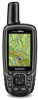
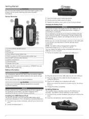
...product box for the device may have to charge a battery that was not provided by Garmin can charge the battery using a standard wall outlet or a USB port on GPSMAP 64s and GPSMAP 64st models only. NOTE: The battery will not charge when outside the temperature range of ... 5 Charge the battery completely. Getting Started WARNING See the Important Safety and Product Information guide in below freezing conditions. Device Overview À Internal GPS/GLONASS antenna Á Keys  Power key à Mini-USB port (under weather cap) Ä MCX connector for best results. 1 ...
...product box for the device may have to charge a battery that was not provided by Garmin can charge the battery using a standard wall outlet or a USB port on GPSMAP 64s and GPSMAP 64st models only. NOTE: The battery will not charge when outside the temperature range of ... 5 Charge the battery completely. Getting Started WARNING See the Important Safety and Product Information guide in below freezing conditions. Device Overview À Internal GPS/GLONASS antenna Á Keys  Power key à Mini-USB port (under weather cap) Ä MCX connector for best results. 1 ...

Quick Start Manual
Page 3
Turning On the Device Hold . shows the GPS/GLONASS signal strength. Select twice to scroll through the main pages. Select to open the options menu for satellites. Select to the waypoint. 3 Select Done. ...
Turning On the Device Hold . shows the GPS/GLONASS signal strength. Select twice to scroll through the main pages. Select to open the options menu for satellites. Select to the waypoint. 3 Select Done. ...


