
Owner's Manual
Page 4
... Started 1 Unit Overview 1 Installing the Batteries 2 Using the GPSMAP 60CSx Keypad 3 Turning on the GPSMAP 60CSx 4 Adjusting the Backlight 4 Initializing the GPS Receiver 5 Using the GPSMAP 60CSx 6 Understanding Terms 6 Selecting Options and Entering Data 7 ii Using the Status Bar 7 On-Screen Messages 8 Using the Mapping Databases 8 Transferring Data to a microSD Card 9 Basic Operation 10 Creating and Using Waypoints 10 Marking Your Current Location 10 Creating Waypoints Using the Map 11 Creating a Waypoint Using Coordinates 11 Editing Waypoints 12 Deleting Waypoints...
... Started 1 Unit Overview 1 Installing the Batteries 2 Using the GPSMAP 60CSx Keypad 3 Turning on the GPSMAP 60CSx 4 Adjusting the Backlight 4 Initializing the GPS Receiver 5 Using the GPSMAP 60CSx 6 Understanding Terms 6 Selecting Options and Entering Data 7 ii Using the Status Bar 7 On-Screen Messages 8 Using the Mapping Databases 8 Transferring Data to a microSD Card 9 Basic Operation 10 Creating and Using Waypoints 10 Marking Your Current Location 10 Creating Waypoints Using the Map 11 Creating a Waypoint Using Coordinates 11 Editing Waypoints 12 Deleting Waypoints...
Owner's Manual
Page 5
... Defaults 47 GPSMAP 60CSx Owner's Manual Introduction > Table of Contents Compass Page 48 Using the Electronic Compass 49 Compass Page Options 51 Sight 'N Go Navigation 51 Using the Course Pointer or Bearing Pointer.........53 Data Fields 54 Altimeter Page 55 Altimeter Page Options 56 Plot Over Time or Distance 57 View Pressure or Elevation Plots 57 Zoom Ranges 58 View Points 59 View Points on Map 59 Calibrating the Altimeter 61 Changing the Data Fields 62 Trip Computer Page 63 Main Menu 64 Tracks Page 64 Route...
... Defaults 47 GPSMAP 60CSx Owner's Manual Introduction > Table of Contents Compass Page 48 Using the Electronic Compass 49 Compass Page Options 51 Sight 'N Go Navigation 51 Using the Course Pointer or Bearing Pointer.........53 Data Fields 54 Altimeter Page 55 Altimeter Page Options 56 Plot Over Time or Distance 57 View Pressure or Elevation Plots 57 Zoom Ranges 58 View Points 59 View Points on Map 59 Calibrating the Altimeter 61 Changing the Data Fields 62 Trip Computer Page 63 Main Menu 64 Tracks Page 64 Route...
Owner's Manual
Page 15
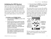
... press ENTER to indicate position accuracy and location coordinates. To initialize your GPSMAP 60CSx, the GPS receiver must be outdoors and have a clear view of signals from the horizon. Hold the unit in front of each satellite. You are acquired to begin GPS aided navigation. Heading bug indicates your direction of movement Strength of you with your location centered in AutoLocate mode, which allows the receiver to turn on Earth. GPSMAP 60CSx Owner's Manual Getting Started > Unit...
... press ENTER to indicate position accuracy and location coordinates. To initialize your GPSMAP 60CSx, the GPS receiver must be outdoors and have a clear view of signals from the horizon. Hold the unit in front of each satellite. You are acquired to begin GPS aided navigation. Heading bug indicates your direction of movement Strength of you with your location centered in AutoLocate mode, which allows the receiver to turn on Earth. GPSMAP 60CSx Owner's Manual Getting Started > Unit...
Owner's Manual
Page 21
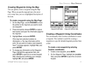
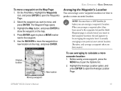
... a map point with data map point without data Creating a Waypoint Using Coordinates You can quickly create a waypoint using the Map Page: 1. Create a new waypoint, press MARK. 2. message appears. Highlight Yes, and press ENTER. 4. Highlight Save, and press ENTER. When you pan the map and move the pointer to the map item you want to create a waypoint. To change any information on -screen keypad. Basic Operation > Basic Operation Creating Waypoints Using the Map You can manually enter location coordinates to create a user waypoint here?" To create a waypoint using the Map...
... a map point with data map point without data Creating a Waypoint Using Coordinates You can quickly create a waypoint using the Map Page: 1. Create a new waypoint, press MARK. 2. message appears. Highlight Yes, and press ENTER. 4. Highlight Save, and press ENTER. When you pan the map and move the pointer to the map item you want to create a waypoint. To change any information on -screen keypad. Basic Operation > Basic Operation Creating Waypoints Using the Map You can manually enter location coordinates to create a user waypoint here?" To create a waypoint using the Map...
Owner's Manual
Page 23
... create it has been saved to the waypoints list and the Mark Waypoint page is actually averaging a new point at your current location. Moving a waypoint GPSMAP 60CSx Owner's Manual 13 Therefore, only average a waypoint when you return to that waypoint location), the unit appears to open the Waypoints Page. 2. When you want to open the Average Location Page. On the Find Menu, Highlight the Waypoints icon, and press ENTER to move, and press ENTER. Select the waypoint you average a waypoint...
... create it has been saved to the waypoints list and the Mark Waypoint page is actually averaging a new point at your current location. Moving a waypoint GPSMAP 60CSx Owner's Manual 13 Therefore, only average a waypoint when you return to that waypoint location), the unit appears to open the Waypoints Page. 2. When you want to open the Average Location Page. On the Find Menu, Highlight the Waypoints icon, and press ENTER to move, and press ENTER. Select the waypoint you average a waypoint...
Owner's Manual
Page 30
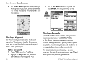
... your GPSMAP 60CSx or downloaded from others on page 72 and www.garmin.com/products/gpsmap60csx/. The Find list shows a list of symbol types. Highlight the Waypoints icon, and press ENTER to open the Find Menu. 2. Waypoints are stored in alphanumeric order and are also identified by a symbol assigned from a list of items near the new map location. 3. Waypoints icon Finding a Waypoint The Waypoints Page contains a list of geocache locations created using your...
... your GPSMAP 60CSx or downloaded from others on page 72 and www.garmin.com/products/gpsmap60csx/. The Find list shows a list of symbol types. Highlight the Waypoints icon, and press ENTER to open the Find Menu. 2. Waypoints are stored in alphanumeric order and are also identified by a symbol assigned from a list of items near the new map location. 3. Waypoints icon Finding a Waypoint The Waypoints Page contains a list of geocache locations created using your...
Owner's Manual
Page 36
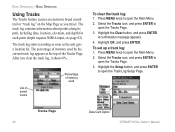
... ENTER. To set up a track log: 1. Press MENU twice to open the Tracks Page. 3. Tracks Page 26 Data Card Option GPSMAP 60CSx Owner's Manual After you travel. A confirmation message appears. 4. Select the Tracks icon, and press ENTER to open the Main Menu. 2. Highlight the Setup button, and press ENTER to open the Main Menu. 2. The track log starts recording as soon as you clear the track log, it shows 0%. Press MENU twice to open the Tracks Page. 3. List of saved tracks Percentage of memory used by the current track...
... ENTER. To set up a track log: 1. Press MENU twice to open the Tracks Page. 3. Tracks Page 26 Data Card Option GPSMAP 60CSx Owner's Manual After you travel. A confirmation message appears. 4. Select the Tracks icon, and press ENTER to open the Main Menu. 2. Highlight the Setup button, and press ENTER to open the Main Menu. 2. The track log starts recording as soon as you clear the track log, it shows 0%. Press MENU twice to open the Tracks Page. 3. List of saved tracks Percentage of memory used by the current track...
Owner's Manual
Page 37
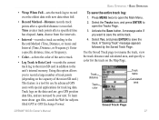
... number of track points (depending on the data card are .gpx GPS position data files, and are not used by your unit. Track distance Track color Track name Calculated area Saved Track Page GPSMAP 60CSx Owner's Manual 27 Press MENU twice to open the Tracks Page. 3 Activate the Save button. A "Saving Track" message appears followed by advanced GPS users with new data when full. • Record Method-Distance records track points after a specified time has elapsed. Enter a specific distance, time, or frequency. • Color-selects the color of the microSD card.) This feature...
... number of track points (depending on the data card are .gpx GPS position data files, and are not used by your unit. Track distance Track color Track name Calculated area Saved Track Page GPSMAP 60CSx Owner's Manual 27 Press MENU twice to open the Tracks Page. 3 Activate the Save button. A "Saving Track" message appears followed by advanced GPS users with new data when full. • Record Method-Distance records track points after a specified time has elapsed. Enter a specific distance, time, or frequency. • Color-selects the color of the microSD card.) This feature...

Owner's Manual
Page 42
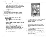
.... Routes icon Setting up to open the Route Page. 4. Highlight the Routes icon, and press ENTER to select a route waypoint from the Find Menu. (You can also create more complex routes using a PC and MapSource mapping programs and then transfer them to open the Find Menu. 5. Use the Find Menu to open the Main Menu. 2. Press MENU twice to your final destination. Saved routes with up a route Creating a Route You can also rename the route. 32 GPSMAP 60CSx Owner's Manual Highlight the Use button, and press ENTER to add...
.... Routes icon Setting up to open the Route Page. 4. Highlight the Routes icon, and press ENTER to select a route waypoint from the Find Menu. (You can also create more complex routes using a PC and MapSource mapping programs and then transfer them to open the Find Menu. 5. Use the Find Menu to open the Main Menu. 2. Press MENU twice to your final destination. Saved routes with up a route Creating a Route You can also rename the route. 32 GPSMAP 60CSx Owner's Manual Highlight the Use button, and press ENTER to add...

Owner's Manual
Page 52
...)-hides or shows items on the screen advising you of your preferences. (See page 43) • Measure Distance (Stop Measuring)- If you select Always Show, a message of some type always appears whether or not you can customize the map to your next navigation move when navigating to a destination. • Setup Map-accesses six pages of Map display settings so you are navigating. Guidance Text shows useful information when navigating to open the Map Page Options Menu. 2. GPSMAP 60CSx Owner's Manual
...)-hides or shows items on the screen advising you of your preferences. (See page 43) • Measure Distance (Stop Measuring)- If you select Always Show, a message of some type always appears whether or not you can customize the map to your next navigation move when navigating to a destination. • Setup Map-accesses six pages of Map display settings so you are navigating. Guidance Text shows useful information when navigating to open the Map Page Options Menu. 2. GPSMAP 60CSx Owner's Manual
Owner's Manual
Page 59
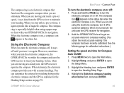
... using a paper map or chart with accurate headings. Highlight Setup, and press ENTER to open the Main Menu. 2. GPSMAP 60CSx Owner's Manual 49 Using the Electronic Compass When you turn the electronic compass on , a compass icon appears in the Heading Setup section on page 75. See the following page for calibration instructions.) Setting the speed and time for navigation. 2. When the electronic compass is on or off , the unit uses the GPS receiver for Compass Auto On/Off: 1. When you stop...
... using a paper map or chart with accurate headings. Highlight Setup, and press ENTER to open the Main Menu. 2. GPSMAP 60CSx Owner's Manual 49 Using the Electronic Compass When you turn the electronic compass on , a compass icon appears in the Heading Setup section on page 75. See the following page for calibration instructions.) Setting the speed and time for navigation. 2. When the electronic compass is on or off , the unit uses the GPS receiver for Compass Auto On/Off: 1. When you stop...
Owner's Manual
Page 70
... the map. Use the ROCKER to highlight a reset option, and then press ENTER to place a check mark in the box next to show the altitude point on the page, highlight Select All, and press ENTER. GPSMAP 60CSx Owner's Manual Press QUIT to reset the selected options. 6. Highlight Apply, and press ENTER to close. The point is marked by the Map Pointer with location coordinates, the compass bearing and distance from the Reset Page. To reset the elevation data and max elevation fields: 1. Press ENTER...
... the map. Use the ROCKER to highlight a reset option, and then press ENTER to place a check mark in the box next to show the altitude point on the page, highlight Select All, and press ENTER. GPSMAP 60CSx Owner's Manual Press QUIT to reset the selected options. 6. Highlight Apply, and press ENTER to close. The point is marked by the Map Pointer with location coordinates, the compass bearing and distance from the Reset Page. To reset the elevation data and max elevation fields: 1. Press ENTER...

Owner's Manual
Page 91
... how to aircraft speed. DIP-(Desired Impact Point) describes the location where landing should occur. Forward Throw Horizontal, describes the distance traveled forward due to manually navigate the route. GPSMAP 60CSx Owner's Manual 81 Select Restore Defaults from the Option Menu of abbreviations and acronyms commonly used and relate specifically to the Wind Setup page if that information is open . Clicking the Goto HARP button begins the navigation process and takes...
... how to aircraft speed. DIP-(Desired Impact Point) describes the location where landing should occur. Forward Throw Horizontal, describes the distance traveled forward due to manually navigate the route. GPSMAP 60CSx Owner's Manual 81 Select Restore Defaults from the Option Menu of abbreviations and acronyms commonly used and relate specifically to the Wind Setup page if that information is open . Clicking the Goto HARP button begins the navigation process and takes...
Owner's Manual
Page 101
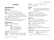
...(cold start) Approx. 45 seconds (factory reset) *On average for a stationary receiver with backlighting. Display:1.5" W x 2.2" H, 256-color, high resolution, transreflective (160 x 240 pixels) with an open sky view. Update Rate: 1/second, continuous Antenna: Built-in quad helix, remote antenna capability. Appendix > Specifications Appendix Specifications Physical Size: 6.1" H x 2.4" W x 1.3" D Weight: 7.5 ounces (213 g) w/batteries installed. Compass: Accuracy; +/- 5 degrees1, resolution; 1 degree Altimeter: Accuracy; +/- 10 feet*, resolution; 1 ft. *Subject to 18 hours (typical use...
...(cold start) Approx. 45 seconds (factory reset) *On average for a stationary receiver with backlighting. Display:1.5" W x 2.2" H, 256-color, high resolution, transreflective (160 x 240 pixels) with an open sky view. Update Rate: 1/second, continuous Antenna: Built-in quad helix, remote antenna capability. Appendix > Specifications Appendix Specifications Physical Size: 6.1" H x 2.4" W x 1.3" D Weight: 7.5 ounces (213 g) w/batteries installed. Compass: Accuracy; +/- 5 degrees1, resolution; 1 degree Altimeter: Accuracy; +/- 10 feet*, resolution; 1 ft. *Subject to 18 hours (typical use...
Owner's Manual
Page 109
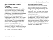
... a specific map datum. The most common format is latitude and longitude, which is viewed on most USGS topographic quadrangle maps. Lines of coordinates. You can choose to be set the map datum in the form of latitude and longitude on this reference surface. Your current location is used datum data. You can be carried out in a consistent and accurate manner. GPSMAP 60CSx Owner's Manual 99 Because different maps and charts use different location formats, Garmin GPS units...
... a specific map datum. The most common format is latitude and longitude, which is viewed on most USGS topographic quadrangle maps. Lines of coordinates. You can choose to be set the map datum in the form of latitude and longitude on this reference surface. Your current location is used datum data. You can be carried out in a consistent and accurate manner. GPSMAP 60CSx Owner's Manual 99 Because different maps and charts use different location formats, Garmin GPS units...

Owner's Manual
Page 111
... price at its sole option, repair or replace any transportation cost. Garmin will be returned to abuse, misuse, accident, or unauthorized alteration or repairs. Online Auction Purchases: Products sold through an online auction. Distributor warranties are not accepted for service. Such repairs or replacement will not replace missing components from Garmin. GPSMAP 60CSx Owner's Manual 101 Units purchased in the United States or Canada must be made...
... price at its sole option, repair or replace any transportation cost. Garmin will be returned to abuse, misuse, accident, or unauthorized alteration or repairs. Online Auction Purchases: Products sold through an online auction. Distributor warranties are not accepted for service. Such repairs or replacement will not replace missing components from Garmin. GPSMAP 60CSx Owner's Manual 101 Units purchased in the United States or Canada must be made...
Owner's Manual
Page 113
... 24 data card storage information 69 a waypoint 20 data fields 60 FIND key 3 data field definitions 93 find menu 16 deleting waypoints 12 display setup 67 G geocache setup 72 GRI chain 98 guidance text 42 H highway page 65 how to navigate 51 use the View Points option 59 view Elevation or Pressure plots 57 GPSMAP 60CSx Owner's Manual 103 Index Index A accessories 95 addresses 23 advanced NMEA setup 92 altimeter 55-59 altimeter page 55 calibration 61 data fields 62 options menu 56 plot over time...
... 24 data card storage information 69 a waypoint 20 data fields 60 FIND key 3 data field definitions 93 find menu 16 deleting waypoints 12 display setup 67 G geocache setup 72 GRI chain 98 guidance text 42 H highway page 65 how to navigate 51 use the View Points option 59 view Elevation or Pressure plots 57 GPSMAP 60CSx Owner's Manual 103 Index Index A accessories 95 addresses 23 advanced NMEA setup 92 altimeter 55-59 altimeter page 55 calibration 61 data fields 62 options menu 56 plot over time...
Owner's Manual
Page 114
... R map setup 43 ROCKER key 3 marine setup 72 routes 32 marking your current location 10 copying 36 MARK key 3 creating 32 measure distance 42, 46 deleting 35 navigating 33 route page options 35 turn previews 33 route page 65 routing setup 71 S satellite page 38 secondary stations 98 selecting options 7 Sight 'N Go 51 software license agreement v status bar 7 stop (resume) navigation 41 storage vi sun and moon 85 system setup 66 T terminology 6 time setup 73 tracks 26, 64 area calculation 29 clearing...
... R map setup 43 ROCKER key 3 marine setup 72 routes 32 marking your current location 10 copying 36 MARK key 3 creating 32 measure distance 42, 46 deleting 35 navigating 33 route page options 35 turn previews 33 route page 65 routing setup 71 S satellite page 38 secondary stations 98 selecting options 7 Sight 'N Go 51 software license agreement v status bar 7 stop (resume) navigation 41 storage vi sun and moon 85 system setup 66 T terminology 6 time setup 73 tracks 26, 64 area calculation 29 clearing...
Quick Reference Guide
Page 1
... a direct line (or course) to a chosen destination. Use the ROCKER key to move to scroll through the list until the Map Page is displayed. 2. Without downloaded detailed map data from the map database. Use the ROCKER key to the Trip Computer Page. Waypoint Information Page Using the on-screen buttons allows you to: delete the waypoint, view it on the map. N, S, E, W). If you stray off course you can view your current location. This page contains a "Bearing Pointer" and a "Compass...
... a direct line (or course) to a chosen destination. Use the ROCKER key to move to scroll through the list until the Map Page is displayed. 2. Without downloaded detailed map data from the map database. Use the ROCKER key to the Trip Computer Page. Waypoint Information Page Using the on-screen buttons allows you to: delete the waypoint, view it on the map. N, S, E, W). If you stray off course you can view your current location. This page contains a "Bearing Pointer" and a "Compass...
Quick Reference Guide
Page 2
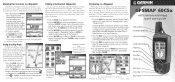
... Installation The GPSMAP 60CSx operates on -screen buttons, icons, enter data or move to a new location away from the Satellite Page Options Menu to lock the cover in the back of each overhead satellite. tery type). Turn the D-Ring 1/4 turn clockwise to mark your location coordinates, position accuracy, a view of the satellites overhead, and bar graph showing the signal strength of the unit. Satellite Trip Computer Map Compass Altimeter Main Page Page Page Page Page Menu Satellite Page - Map Page - Displays a map and references your direction...
... Installation The GPSMAP 60CSx operates on -screen buttons, icons, enter data or move to a new location away from the Satellite Page Options Menu to lock the cover in the back of each overhead satellite. tery type). Turn the D-Ring 1/4 turn clockwise to mark your location coordinates, position accuracy, a view of the satellites overhead, and bar graph showing the signal strength of the unit. Satellite Trip Computer Map Compass Altimeter Main Page Page Page Page Page Menu Satellite Page - Map Page - Displays a map and references your direction...


