Owner's Manual
Page 3
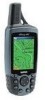
... the Garmin GPSmap 60C handheld navigation system. Appendix - contact Garmin Product Support by subject. NOTE: If you have any difficulty while using your purchase ensures you the best possible support from Garmin. GPS Features - provides you with your GPSmap 60C and how to use GPS Navigation features to re-register using the unit control buttons, initializing the receiver...
... the Garmin GPSmap 60C handheld navigation system. Appendix - contact Garmin Product Support by subject. NOTE: If you have any difficulty while using your purchase ensures you the best possible support from Garmin. GPS Features - provides you with your GPSmap 60C and how to use GPS Navigation features to re-register using the unit control buttons, initializing the receiver...
Owner's Manual
Page 14
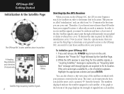
...in order to determine your general location so the GPSmap 60C can search for the satellite signals, a "Locating Satellites" message is replaced by the Satellite Page. 3. GPSmap 60C Getting Started Initialization & the Satellite Page The GPSmap 60C locates satellites above your position. To initialize your... to search for satellites in the array. While the GPS receiver is called "initialization" and can also observe a sky view array of movement. In order to receive satellite signals, you turn on the GPSmap 60C, the GPS receiver begins to turn on the unit. 2. Options Menu ...
...in order to determine your general location so the GPSmap 60C can search for the satellite signals, a "Locating Satellites" message is replaced by the Satellite Page. 3. GPSmap 60C Getting Started Initialization & the Satellite Page The GPSmap 60C locates satellites above your position. To initialize your... to search for satellites in the array. While the GPS receiver is called "initialization" and can also observe a sky view array of movement. In order to receive satellite signals, you turn on the GPSmap 60C, the GPS receiver begins to turn on the unit. 2. Options Menu ...
Owner's Manual
Page 15
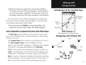
... of other features. A Track allows you your current location, marks your GPSmap 60C, the solution could be as simple as moving slightly to a selected destination (waypoint, city, address, etc.). GPSmap 60C Getting Started Initialization & The Satellite Page Position Arrow Map Scale Map Item ...Details Map Page with Current Position Arrow Navigating with a route line and leaves a trail (track log) of the page changes to begin GPS-aided navigation. 4. When the receiver has signals...
... of other features. A Track allows you your current location, marks your GPSmap 60C, the solution could be as simple as moving slightly to a selected destination (waypoint, city, address, etc.). GPSmap 60C Getting Started Initialization & The Satellite Page Position Arrow Map Scale Map Item ...Details Map Page with Current Position Arrow Navigating with a route line and leaves a trail (track log) of the page changes to begin GPS-aided navigation. 4. When the receiver has signals...

Owner's Manual
Page 21
... option and press the ENTER key to the GPSmap 60C. Press ENTER again to select from other devices interfaced to place a highlight in that field. 4. Three Data Fields Four Data Fields Some Data Field Options are related to the display of data received from a list of types of navigation data ... leave the Map Page as is (full page map), or add two, three or four navigation data fields. 3. To display Data Fields: 1. GPSmap 60C GPS Navigation The Map Page Data Field Sub-Menu Two Data Fields To change Data Fields: 1. You can choose to highlight the Data Fields option and...
... option and press the ENTER key to the GPSmap 60C. Press ENTER again to select from other devices interfaced to place a highlight in that field. 4. Three Data Fields Four Data Fields Some Data Field Options are related to the display of data received from a list of types of navigation data ... leave the Map Page as is (full page map), or add two, three or four navigation data fields. 3. To display Data Fields: 1. GPSmap 60C GPS Navigation The Map Page Data Field Sub-Menu Two Data Fields To change Data Fields: 1. You can choose to highlight the Data Fields option and...
Owner's Manual
Page 56
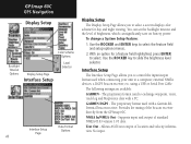
... the brightness level selector. using a USB or Serial Port Cable The following settings are available: GARMIN - Allows ASCII text output of the beacon receiver directly from the GPSmap 60C. No input. Interface Setup The Interface Setup Page allows you to select a screen display color ...on battery power. You can set the backlight timeout and the level of standard NMEA 0183 version 3.01 data. GARMIN DGPS - GPSmap 60C GPS Navigation Display Setup Color Scheme Options Backlight Timeout Options Display Setup Page Interface Setup Level Selector Data Format Interface Setup Options...
... the brightness level selector. using a USB or Serial Port Cable The following settings are available: GARMIN - Allows ASCII text output of the beacon receiver directly from the GPSmap 60C. No input. Interface Setup The Interface Setup Page allows you to select a screen display color ...on battery power. You can set the backlight timeout and the level of standard NMEA 0183 version 3.01 data. GARMIN DGPS - GPSmap 60C GPS Navigation Display Setup Color Scheme Options Backlight Timeout Options Display Setup Page Interface Setup Level Selector Data Format Interface Setup Options...
Owner's Manual
Page 57
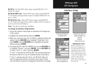
...For Garmin DGPS or RTCM In/NMEA Out, use the ROCKER key to scan for : NMEA In/NMEA Out Text Out RTCM In RTCM In/Text Out IMPORTANT NOTE: When the USB cable is connected to the GPSmap 60C, it is selected, the GPSmap 60C will automatically direct the beacon receiver to...DGPS input using a standard RTCM SC-104 format. RTCM In/Text Out - Provides no interfacing capabilities. If "User" is connected, Garmin format will appear. GPSmap 60C GPS Navigation Interface Setup Data Format Page for GARMIN DGPS Data Format Page for RTCM In/NMEA Out Data Format Page for available beacon transmitters.
...For Garmin DGPS or RTCM In/NMEA Out, use the ROCKER key to scan for : NMEA In/NMEA Out Text Out RTCM In RTCM In/Text Out IMPORTANT NOTE: When the USB cable is connected to the GPSmap 60C, it is selected, the GPSmap 60C will automatically direct the beacon receiver to...DGPS input using a standard RTCM SC-104 format. RTCM In/Text Out - Provides no interfacing capabilities. If "User" is connected, Garmin format will appear. GPSmap 60C GPS Navigation Interface Setup Data Format Page for GARMIN DGPS Data Format Page for RTCM In/NMEA Out Data Format Page for available beacon transmitters.

Owner's Manual
Page 78
GPSmap 60C Appendix Specifications GPSmap 60C 68 PHYSICAL Case: Size: Weight: Display: Antenna: Keypad: Operating Range: Rugged, fully gasketed, water resistant, IEC60529 IPX7 (Submersible 1 meter @ 30 minutes) 6.1"H x 2.4"W x 1.3"D ...-in quadrifilar, with remote antenna capability (MCX connector) Nine multifunction backlit keys 5 to 158oF (-15 to 70oC)1 PERFORMANCE Receiver: Acquisition Time: Update Rate: GPS Accuracy Position: Velocity: WAAS enabled, 12 parallel channel Warm: Approximately 15 seconds Cold: Approximately 45 seconds AutoLocate™: Approximately 5 minutes...
GPSmap 60C Appendix Specifications GPSmap 60C 68 PHYSICAL Case: Size: Weight: Display: Antenna: Keypad: Operating Range: Rugged, fully gasketed, water resistant, IEC60529 IPX7 (Submersible 1 meter @ 30 minutes) 6.1"H x 2.4"W x 1.3"D ...-in quadrifilar, with remote antenna capability (MCX connector) Nine multifunction backlit keys 5 to 158oF (-15 to 70oC)1 PERFORMANCE Receiver: Acquisition Time: Update Rate: GPS Accuracy Position: Velocity: WAAS enabled, 12 parallel channel Warm: Approximately 15 seconds Cold: Approximately 45 seconds AutoLocate™: Approximately 5 minutes...
Owner's Manual
Page 89
...)? Using DGPS requires interfacing of your Garmin GPS. Refer to http://gps.faa.gov/Programs/WAAS/waas.htm. For more information, go to the section titled "Interface Setup." The U.S. funded project to additional equipment in the position.... Department of the differential beacon sites. GPSmap 60C Appendix WAAS and DGPS 79 What is WAAS? They are operational in the developmental stage with a goal of providing reliable signals with the RTCM format sentences supported by your unit to improve the overall integrity of a beacon receiver compatible with an accuracy of 7 meters...
...)? Using DGPS requires interfacing of your Garmin GPS. Refer to http://gps.faa.gov/Programs/WAAS/waas.htm. For more information, go to the section titled "Interface Setup." The U.S. funded project to additional equipment in the position.... Department of the differential beacon sites. GPSmap 60C Appendix WAAS and DGPS 79 What is WAAS? They are operational in the developmental stage with a goal of providing reliable signals with the RTCM format sentences supported by your unit to improve the overall integrity of a beacon receiver compatible with an accuracy of 7 meters...
Owner's Manual
Page 90
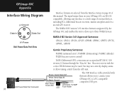
... the GPSmap 60C and enables the unit to drive up to a PC-compatible computer's USB port. Beacon receivers with this manual. NMEA 0183 Version 3.01 Approved Sentences: GPGGA, GPGLL, GPGSA, GPGSV, GPRMB, GPRMC, GPRTE, GPVTG, GPWPL, GPBOD Garmin Proprietary Sentences: PGRME (estimated error), PGRMM (datum string), PGRMZ (altitude), PSLIB (beacon receiver control) DGPS (Differential GPS) corrections...
... the GPSmap 60C and enables the unit to drive up to a PC-compatible computer's USB port. Beacon receivers with this manual. NMEA 0183 Version 3.01 Approved Sentences: GPGGA, GPGLL, GPGSA, GPGSV, GPRMB, GPRMC, GPRTE, GPVTG, GPWPL, GPBOD Garmin Proprietary Sentences: PGRME (estimated error), PGRMM (datum string), PGRMZ (altitude), PSLIB (beacon receiver control) DGPS (Differential GPS) corrections...

