Owner's Manual
Page 3
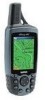
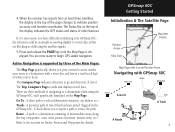
... Time; This Owner's Manual and Reference Guide is lost, stolen, or needs service. GPSmap 60C Introduction Preface Contact Garmin If you should encounter any questions, in the U.S.A. takes you through the process of navigating with additional information about your GPSmap 60C, or if you for choosing the Garmin GPSmap 60C handheld navigation system. takes you through installing batteries, using your GPSmap 60C and an index by our product registration system are a few non-GPS features...
... Time; This Owner's Manual and Reference Guide is lost, stolen, or needs service. GPSmap 60C Introduction Preface Contact Garmin If you should encounter any questions, in the U.S.A. takes you through the process of navigating with additional information about your GPSmap 60C, or if you for choosing the Garmin GPSmap 60C handheld navigation system. takes you through installing batteries, using your GPSmap 60C and an index by our product registration system are a few non-GPS features...

Owner's Manual
Page 8
.... Do Not Mount Where Driver's Field of Vision is the sole responsibility of the owner/operator of a vehicle with the vehicle operating controls and safety devices, obstruct the driver's view of driving conditions, or cause damage or personal injury in the event of safe driving practices. WARNING: For use in vehicles, it will not interfere with the GPSmap 60C installed to impact it...
.... Do Not Mount Where Driver's Field of Vision is the sole responsibility of the owner/operator of a vehicle with the vehicle operating controls and safety devices, obstruct the driver's view of driving conditions, or cause damage or personal injury in the event of safe driving practices. WARNING: For use in vehicles, it will not interfere with the GPSmap 60C installed to impact it...
Owner's Manual
Page 11
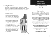
Turn the D-Ring 1/4 turn clockwise to lock in place. Insert the batteries, observing the proper polarity. Pin Slot 3. USE BY: 2009 USE BY: 2009 Battery Compartment GPSmap 60C Getting Started Battery Installation and Start Up Important Note When replacing batteries, use it for prolonged periods of backlighting and/or WAAS as well as internal materials may typically display less capacity than disposable batteries. Storing batteries in the back of used batteries, as key beep...
Turn the D-Ring 1/4 turn clockwise to lock in place. Insert the batteries, observing the proper polarity. Pin Slot 3. USE BY: 2009 USE BY: 2009 Battery Compartment GPSmap 60C Getting Started Battery Installation and Start Up Important Note When replacing batteries, use it for prolonged periods of backlighting and/or WAAS as well as internal materials may typically display less capacity than disposable batteries. Storing batteries in the back of used batteries, as key beep...
Owner's Manual
Page 14
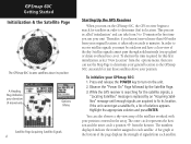
... Menu Satellite Page Acquiring Satellite Signals 4 Starting Up the GPS Receiver When you must be outdoors and have a clear view of solutions appears. This process is replaced by the Satellite Page. 3. The outer circle represents the horizon and the inner circle a position 45o from each satellite. The numbers displayed indicate the number assigned to 15 minutes the first time you use the Map Page to turn on the GPSmap 60C, the GPS receiver...
... Menu Satellite Page Acquiring Satellite Signals 4 Starting Up the GPS Receiver When you must be outdoors and have a clear view of solutions appears. This process is replaced by the Satellite Page. 3. The outer circle represents the horizon and the inner circle a position 45o from each satellite. The numbers displayed indicate the number assigned to 15 minutes the first time you use the Map Page to turn on the GPSmap 60C, the GPS receiver...
Owner's Manual
Page 15
... the receiver has signals from at least three satellites, the display at the top of the display indicates the GPS status and status of other features. Route - The Compass Page indicates direction to indicate position accuracy and location coordinates. There are now ready to avoid objects that has been stored (logged) in the GPSmap 60C. A previous path of navigating to a destination when using the GPSmap 60C, each graphically displayed on Tracks, Routes and Waypoints...
... the receiver has signals from at least three satellites, the display at the top of the display indicates the GPS status and status of other features. Route - The Compass Page indicates direction to indicate position accuracy and location coordinates. There are now ready to avoid objects that has been stored (logged) in the GPSmap 60C. A previous path of navigating to a destination when using the GPSmap 60C, each graphically displayed on Tracks, Routes and Waypoints...
Owner's Manual
Page 18
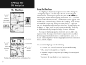
... dim light. When you to your current location. The Map Page displays a detailed map of the GPSmap 60C. You can be changed to orient the map. GPSmap 60C GPS Navigation The Map Page "North Up" Mode with Map oriented with North at the top The Map Scale The Map Page Position Arrow "Track Up" Mode North Orientation Arrow Data Fields Guidance Text Street Level Detailed Mapping The Map Page with Data Fields and Guidance Text 8 Using the Map Page The Map Page is the primary navigation feature...
... dim light. When you to your current location. The Map Page displays a detailed map of the GPSmap 60C. You can be changed to orient the map. GPSmap 60C GPS Navigation The Map Page "North Up" Mode with Map oriented with North at the top The Map Scale The Map Page Position Arrow "Track Up" Mode North Orientation Arrow Data Fields Guidance Text Street Level Detailed Mapping The Map Page with Data Fields and Guidance Text 8 Using the Map Page The Map Page is the primary navigation feature...
Owner's Manual
Page 20
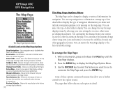
... on the map. You can customize the map to your current location to the Map Pointer. With unit turned On, press and release the PAGE key until the Map Page displays. 2. Use the ROCKER key to select the feature you can display the distance from your preferences. Setup Map - You can restore the Map Page display to the factory default settings. Turn Declutter On - You can stop navigation to a destination, arrange up to four data fields to display the type of navigation information you...
... on the map. You can customize the map to your current location to the Map Pointer. With unit turned On, press and release the PAGE key until the Map Page displays. 2. Use the ROCKER key to select the feature you can display the distance from your preferences. Setup Map - You can restore the Map Page display to the factory default settings. Turn Declutter On - You can stop navigation to a destination, arrange up to four data fields to display the type of navigation information you...
Owner's Manual
Page 29
...to display the Average location Page. Editing a Waypoint A waypoint can be selected from the Find Feature Waypoints list and edited to change the map symbol, name, location coordinates, elevation or to delete. Highlight the "Save" button and press ENTER when desired. GPSmap 60C GPS Navigation Using Waypoints Waypoint Symbols Chart Delete Button Waypoint Options Menu Average Location Page 19 Select "Average Location" and press ENTER to average automatically. 3. Answer "Yes" to the pop-up prompt and press ENTER to delete it . A waypoint location can be averaged over time...
...to display the Average location Page. Editing a Waypoint A waypoint can be selected from the Find Feature Waypoints list and edited to change the map symbol, name, location coordinates, elevation or to delete. Highlight the "Save" button and press ENTER when desired. GPSmap 60C GPS Navigation Using Waypoints Waypoint Symbols Chart Delete Button Waypoint Options Menu Average Location Page 19 Select "Average Location" and press ENTER to average automatically. 3. Answer "Yes" to the pop-up prompt and press ENTER to delete it . A waypoint location can be averaged over time...

Owner's Manual
Page 31
... loaded, these options can speed your current location or the Panning Arrow (if active). • To save effort in searching again for Waypoints), "Change Reference" (by default it contains only those groups such as Wrecks and Obstructions, NAVAIDS, and Anchorages. If you have downloaded Garmin MapSource mapping data that contains additional map detail, you can find detailed Marine items such as Food and...
... loaded, these options can speed your current location or the Panning Arrow (if active). • To save effort in searching again for Waypoints), "Change Reference" (by default it contains only those groups such as Wrecks and Obstructions, NAVAIDS, and Anchorages. If you have downloaded Garmin MapSource mapping data that contains additional map detail, you can find detailed Marine items such as Food and...
Owner's Manual
Page 33
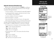
...; An information field (if a waypoint, information you select a Find item and press the ENTER key, an Informa- remove from current location or the map pointer. insert into a list of points, these three buttons displays as a waypoint. start a Go To navigation. • If selecting an item to add to a route list as a waypoint. • If selecting an item as a destination, the buttons display as a Point on a Route or Track 23 Use - Using the Find Item Information Page When you add, if a map item, an...
...; An information field (if a waypoint, information you select a Find item and press the ENTER key, an Informa- remove from current location or the map pointer. insert into a list of points, these three buttons displays as a waypoint. start a Go To navigation. • If selecting an item to add to a route list as a waypoint. • If selecting an item as a destination, the buttons display as a Point on a Route or Track 23 Use - Using the Find Item Information Page When you add, if a map item, an...
Owner's Manual
Page 37
... Compass Page changes to "Geocache Navigation" mode and any additional information about a geocache "Find Next" Option 27 Use the ROCKER key to highlight the Geocache icon and press ENTER to display the information page. 4. GPSmap 60C GPS Navigation Using Find Options Menu To find a Geocache: 1. Use the ROCKER key to highlight the desired geocache in the comment field. Searching for a Geocache The Find Geocache feature allows you to view the list of geocache locations that you reach a geocache Use the Data button...
... Compass Page changes to "Geocache Navigation" mode and any additional information about a geocache "Find Next" Option 27 Use the ROCKER key to highlight the Geocache icon and press ENTER to display the information page. 4. GPSmap 60C GPS Navigation Using Find Options Menu To find a Geocache: 1. Use the ROCKER key to highlight the desired geocache in the comment field. Searching for a Geocache The Find Geocache feature allows you to view the list of geocache locations that you reach a geocache Use the Data button...
Owner's Manual
Page 49
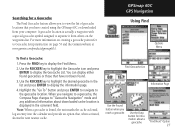
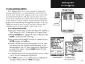
... waypoint cannot be created using the "Follow Roads" option. Use the ROCKER key to highlight the "New" button and press ENTER to display the route Setup Page. 3. To add more than 50 waypoints cannot be added to a route from the Routes Page, and waypoints can rename the route if desired. 6. Highlight the on the Route Waypoint List. 5. GPSmap 60C GPS Navigation Using Routes Indicates Active Route Options Menu List of saved routes. 2. Press QUIT to save a route: 1. Creating and Using a Route Route navigation allows you to create...
... waypoint cannot be created using the "Follow Roads" option. Use the ROCKER key to highlight the "New" button and press ENTER to display the route Setup Page. 3. To add more than 50 waypoints cannot be added to a route from the Routes Page, and waypoints can rename the route if desired. 6. Highlight the on the Route Waypoint List. 5. GPSmap 60C GPS Navigation Using Routes Indicates Active Route Options Menu List of saved routes. 2. Press QUIT to save a route: 1. Creating and Using a Route Route navigation allows you to create...

Owner's Manual
Page 55
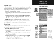
... follow. Each selectable setup page is identified by an icon, which when highlighted displays the page when you press ENTER. To view the software version, press MENU, select "Software Version" and press ENTER. The Setup Menu The Setup Menu allows you to customize the GPSmap 60C to your unit, choose a display text language, set options for operation when disconnected from four modes of GPS operation, enable/disable WAAS (see page 78), designate battery type currently being used to power your personal...
... follow. Each selectable setup page is identified by an icon, which when highlighted displays the page when you press ENTER. To view the software version, press MENU, select "Software Version" and press ENTER. The Setup Menu The Setup Menu allows you to customize the GPSmap 60C to your unit, choose a display text language, set options for operation when disconnected from four modes of GPS operation, enable/disable WAAS (see page 78), designate battery type currently being used to power your personal...
Owner's Manual
Page 56
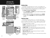
...output of brightness, which can significantly save on battery power. Use the ROCKER and ENTER keys to exchange waypoint, route, track log and MapSource data with a Garmin differential beacon receiver. using a USB or Serial Port Cable The following settings are available: GARMIN - The proprietary format used to select the feature field and setup options menus. 2. The proprietary format used with a PC. GARMIN DGPS - Provides for day and night viewing. GPSmap 60C GPS Navigation Display Setup Color Scheme Options Backlight Timeout Options Display Setup Page Interface Setup...
...output of brightness, which can significantly save on battery power. Use the ROCKER and ENTER keys to exchange waypoint, route, track log and MapSource data with a Garmin differential beacon receiver. using a USB or Serial Port Cable The following settings are available: GARMIN - The proprietary format used to select the feature field and setup options menus. 2. The proprietary format used with a PC. GARMIN DGPS - Provides for day and night viewing. GPSmap 60C GPS Navigation Display Setup Color Scheme Options Backlight Timeout Options Display Setup Page Interface Setup...
Owner's Manual
Page 63
... ENTER to activate the desired alarm and press ENTER. 3. Refer to maritime navigation. Highlight the box in violation of ordinances or laws governing use the Marine Setup feature: 1. Select "Yes" or "No" for features specific to the Garmin website, www.garmin.com, for each checked box, press ENTER and use the Geocache Setup feature: 1. Highlight the field adjacent to download geocache locations from the default open and closed geocache symbols. To use the Number Keypad to enter...
... ENTER to activate the desired alarm and press ENTER. 3. Refer to maritime navigation. Highlight the box in violation of ordinances or laws governing use the Marine Setup feature: 1. Select "Yes" or "No" for features specific to the Garmin website, www.garmin.com, for each checked box, press ENTER and use the Geocache Setup feature: 1. Highlight the field adjacent to download geocache locations from the default open and closed geocache symbols. To use the Number Keypad to enter...
Owner's Manual
Page 76
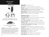
... connection to belt or waistband. Allows installation on bicycle handlebar. Similar to the list of the warranty. Owner's Manual - Start up instructions and detailed operation reference. Bicycle Mount Kit - GA 27C Remote GPS Antenna with USB cable drivers. Note: Refer to the belt clip, but with the Unit) Wrist Strap - GPSmap 60C Appendix Accessories Belt Clip Assembly USB Interface Cable and MapSource Trip and Waypoint Manager CD-ROM with MCX Connector. Using Garmin...
... connection to belt or waistband. Allows installation on bicycle handlebar. Similar to the list of the warranty. Owner's Manual - Start up instructions and detailed operation reference. Bicycle Mount Kit - GA 27C Remote GPS Antenna with USB cable drivers. Note: Refer to the belt clip, but with the Unit) Wrist Strap - GPSmap 60C Appendix Accessories Belt Clip Assembly USB Interface Cable and MapSource Trip and Waypoint Manager CD-ROM with MCX Connector. Using Garmin...
Owner's Manual
Page 80
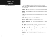
... your current speed and course. Elevation - The distance above or below mean sea level. Glide Ratio - The ratio of arrival at the next point on a route. The current accuracy of each data field option. Course - The distance to a destination point. GPSmap 60C Appendix Data Field Options 70 The following list provides a brief description of your GPS determined location. The estimated time of horizontal distance traveled to your destination point. Accuracy GPS - The compass direction from your current speed and course. ETA...
... your current speed and course. Elevation - The distance above or below mean sea level. Glide Ratio - The ratio of arrival at the next point on a route. The current accuracy of each data field option. Course - The distance to a destination point. GPSmap 60C Appendix Data Field Options 70 The following list provides a brief description of your GPS determined location. The estimated time of horizontal distance traveled to your destination point. Accuracy GPS - The compass direction from your current speed and course. ETA...

Owner's Manual
Page 88
... chain number and secondary stations to a TD coordinate anywhere in the world. To change the settings of any of this, the unit can navigate to create a LORAN TD position. When done, highlight the "Save" button and press ENTER. GPSmap 60C Appendix Loran TD Setup Location Setup Page (Position Format List with Loran TD selected.) Loran TD Setup Page 78 To set up Loran TD from the Setup Menu: 1. Highlight "Loran TD" press ENTER to display...
... chain number and secondary stations to a TD coordinate anywhere in the world. To change the settings of any of this, the unit can navigate to create a LORAN TD position. When done, highlight the "Save" button and press ENTER. GPSmap 60C Appendix Loran TD Setup Location Setup Page (Position Format List with Loran TD selected.) Loran TD Setup Page 78 To set up Loran TD from the Setup Menu: 1. Highlight "Loran TD" press ENTER to display...

Owner's Manual
Page 91
... Geocache 27 Compass Page 14 Find Intersections 31 Compass Ring 14 Find Points of Interest 32 Course Pointer 15 Custom Waypoint Symbols 17 K Key Functions 2 L Location (Marking) 17-18 Loading Map Data 75 Lock On Road 50 Loran TD Setup 78 M Main Menu Page 6, 33 Map Datums 54, 77 Nearest (Waypoints, Cities, Exits, etc.) 21 NMEA 46 Normal Mode 45 North Reference 55 North Up 8, 50 O Odometer 16 Offset (Time) 54, 76 Orient Map 50 Overall Average Speed...
... Geocache 27 Compass Page 14 Find Intersections 31 Compass Ring 14 Find Points of Interest 32 Course Pointer 15 Custom Waypoint Symbols 17 K Key Functions 2 L Location (Marking) 17-18 Loading Map Data 75 Lock On Road 50 Loran TD Setup 78 M Main Menu Page 6, 33 Map Datums 54, 77 Nearest (Waypoints, Cities, Exits, etc.) 21 NMEA 46 Normal Mode 45 North Reference 55 North Up 8, 50 O Odometer 16 Offset (Time) 54, 76 Orient Map 50 Overall Average Speed...

Owner's Manual
Page 92
GPSmap 60C Appendix Index P Page Sequence Setup 48 Panning (Map) 18 Position Format 55, 77 Product Registration i Projecting a Waypoint 20 Proximity Waypoints 56 R Reset Trip Page 16 Routes 39-43 Creating 39 Copying 43 Deleting 43 Editing 43 Navigating 43 Reversing 41 Routing Setup 52 S Satellite Page 4 Saving the Tracklog 35 Selecting a Page 2 Setup Menu 33 Show Data Fields 10 Show Map Only 10 Software Version (Operating) 45 Specifications 68 82 Stop Navigation 10, 14, 41 Stopwatch Page 59 Sun...
GPSmap 60C Appendix Index P Page Sequence Setup 48 Panning (Map) 18 Position Format 55, 77 Product Registration i Projecting a Waypoint 20 Proximity Waypoints 56 R Reset Trip Page 16 Routes 39-43 Creating 39 Copying 43 Deleting 43 Editing 43 Navigating 43 Reversing 41 Routing Setup 52 S Satellite Page 4 Saving the Tracklog 35 Selecting a Page 2 Setup Menu 33 Show Data Fields 10 Show Map Only 10 Software Version (Operating) 45 Specifications 68 82 Stop Navigation 10, 14, 41 Stopwatch Page 59 Sun...


