Owner's Manual
Page 4
... On 2 Turning the Chartplotter Off 2 Initializing Chartplotter Settings 2 Acquiring GPS Satellite Signals 3 Adjusting the Backlight 3 Adjusting the Color Mode 3 Inserting and Removing SD Cards 3 Restoring the Original Factory Settings 4 Viewing System Information 4 Using the Simulator Mode 4 Understanding the Home Screen 5 Using Charts 6 Using the Navigation Chart 6 Changing the Navigation Chart Settings 11 Using Perspective 3D 12 Using Radar Overlay 14 Using Tracks 14 Using BlueChart g2 Vision 15 Using Mariner's Eye 3D 16 Using Fish Eye 3D 17 Using Fishing Charts 18...
... On 2 Turning the Chartplotter Off 2 Initializing Chartplotter Settings 2 Acquiring GPS Satellite Signals 3 Adjusting the Backlight 3 Adjusting the Color Mode 3 Inserting and Removing SD Cards 3 Restoring the Original Factory Settings 4 Viewing System Information 4 Using the Simulator Mode 4 Understanding the Home Screen 5 Using Charts 6 Using the Navigation Chart 6 Changing the Navigation Chart Settings 11 Using Perspective 3D 12 Using Radar Overlay 14 Using Tracks 14 Using BlueChart g2 Vision 15 Using Mariner's Eye 3D 16 Using Fish Eye 3D 17 Using Fishing Charts 18...

Owner's Manual
Page 9
... navigation features (page 23). • Radar-sets up and displays radar (only available if the chartplotter is connected to a radar module) (page 45). • Weather-sets up the screen to the marked location. (page 25). Getting Started Understanding the Home Screen Use the Home screen to access all other boats, gauges, and video (page 30). • Mark-marks, edits, or deletes your current location as a waypoint, and sets a course back to view a chart, sonar, radar, and video in a 2, 3, or 4-field split screen (page 21). • Information-shows information...
... navigation features (page 23). • Radar-sets up and displays radar (only available if the chartplotter is connected to a radar module) (page 45). • Weather-sets up the screen to the marked location. (page 25). Getting Started Understanding the Home Screen Use the Home screen to access all other boats, gauges, and video (page 30). • Mark-marks, edits, or deletes your current location as a waypoint, and sets a course back to view a chart, sonar, radar, and video in a 2, 3, or 4-field split screen (page 21). • Information-shows information...
Owner's Manual
Page 17
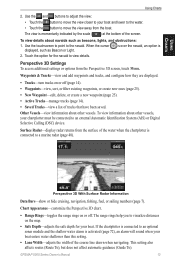
... (page 14). • Waypoints-view, sort, or filter existing waypoints, or create new ones (page 25). • New Waypoint-edit, delete, or create a new waypoint (page 25). • Active Tracks-manage tracks (page 14). • Saved Tracks-view a list of the screen. Waypoints & Tracks-view and add waypoints and tracks, and configure how they are displayed. • Tracks-turn tracks on or off . Perspective 3D Settings To access additional settings or options from the boat. GPSMAP 5000 Series Owner's Manual 13
... (page 14). • Waypoints-view, sort, or filter existing waypoints, or create new ones (page 25). • New Waypoint-edit, delete, or create a new waypoint (page 25). • Active Tracks-manage tracks (page 14). • Saved Tracks-view a list of the screen. Waypoints & Tracks-view and add waypoints and tracks, and configure how they are displayed. • Tracks-turn tracks on or off . Perspective 3D Settings To access additional settings or options from the boat. GPSMAP 5000 Series Owner's Manual 13

Owner's Manual
Page 19
...) along the shore. • Auto Guidance-uses specified boat safe depth and chart data to determine the best course to your destination. Recording more-frequent plots is recommended for a three‑dimensional navigation aid. The distance value (Change) is recorded. In addition to set active Track Options: From the Home screen, touch Information > User Data > Tracks > Active Track Options. GPSMAP 5000 Series Owner's Manual 15 Track Color-sets the color of your chartplotter. The BlueChart g2 Vision Mariner's Eye 3D is more...
...) along the shore. • Auto Guidance-uses specified boat safe depth and chart data to determine the best course to your destination. Recording more-frequent plots is recommended for a three‑dimensional navigation aid. The distance value (Change) is recorded. In addition to set active Track Options: From the Home screen, touch Information > User Data > Tracks > Active Track Options. GPSMAP 5000 Series Owner's Manual 15 Track Color-sets the color of your chartplotter. The BlueChart g2 Vision Mariner's Eye 3D is more...
Owner's Manual
Page 42
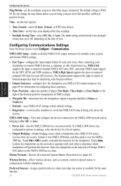
... device for the same function. 38 GPSMAP 5000 Series Owner's Manual Do not change the map datum unless you are using a map or chart that NMEA 0183 data is structured. Configuring the Device Configuring Communications Settings From the Home screen, touch Configure > Communications. Marine Network-Review all connected Garmin Marine Network devices (page 43). Preferred Sources-Assign a preferred device when more than one chartplotter on the network to the right of the decimal...
... device for the same function. 38 GPSMAP 5000 Series Owner's Manual Do not change the map datum unless you are using a map or chart that NMEA 0183 data is structured. Configuring the Device Configuring Communications Settings From the Home screen, touch Configure > Communications. Marine Network-Review all connected Garmin Marine Network devices (page 43). Preferred Sources-Assign a preferred device when more than one chartplotter on the network to the right of the decimal...
Owner's Manual
Page 43
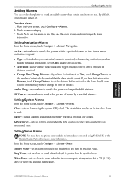
... Home screen, touch Configure > Alarms > Sonar. GPSMAP 5000 Series Owner's Manual 39 Arrival-set the chartplotter to sound an audible alarm when certain conditions are met. Off Course-sets an alarm to sound when you are off . Clock-sets an alarm using NMEA 0183 or the Garmin Marine Network to receive sonar information. Touch an alarm category. 3. Setting Sonar Alarms Note: You must be on -screen keyboard to change the time or distance. Configuring the Device Configuring the Device Setting Alarms You can set an alarm...
... Home screen, touch Configure > Alarms > Sonar. GPSMAP 5000 Series Owner's Manual 39 Arrival-set the chartplotter to sound an audible alarm when certain conditions are met. Off Course-sets an alarm to sound when you are off . Clock-sets an alarm using NMEA 0183 or the Garmin Marine Network to receive sonar information. Touch an alarm category. 3. Setting Sonar Alarms Note: You must be on -screen keyboard to change the time or distance. Configuring the Device Configuring the Device Setting Alarms You can set an alarm...

Owner's Manual
Page 45
... the Home screen, touch Configure > Other Vessels. AIS alerts you to the water line (transducer installed on the bottom of the keel), enter a (-) negative number. Configuring the Device GPSMAP 5000 Series Owner's Manual 41 This shows the depth at the bottom of the keel. DSC-turn DSC on or off. to 2.0 nm (or from 150 m to accept the number. From the Home screen, touch Configure > My Boat > Keel Offset. 2. This shows the depth at the water line), enter a (+) positive number...
... the Home screen, touch Configure > Other Vessels. AIS alerts you to the water line (transducer installed on the bottom of the keel), enter a (-) negative number. Configuring the Device GPSMAP 5000 Series Owner's Manual 41 This shows the depth at the bottom of the keel. DSC-turn DSC on or off. to 2.0 nm (or from 150 m to accept the number. From the Home screen, touch Configure > My Boat > Keel Offset. 2. This shows the depth at the water line), enter a (+) positive number...
Owner's Manual
Page 47
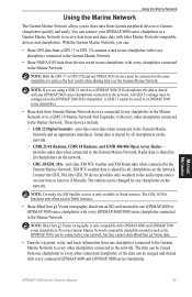
... the Garmin Marine Network. GPSMAP 5000 Series Owner's Manual 43 Marine Network These devices include: ◦ GSD 22 Digital Sounder-provides sonar data when connected to XM audio. XM WX weather data is only available in one chartplotter to every other Marine Network-compatible devices and chartplotters. The GDL 30/30A functions only when used in North America. • Share BlueChart g2 Vision cartography data from an SD card inserted in North America. NOTE: Currently, the XM Satellite service...
... the Garmin Marine Network. GPSMAP 5000 Series Owner's Manual 43 Marine Network These devices include: ◦ GSD 22 Digital Sounder-provides sonar data when connected to XM audio. XM WX weather data is only available in one chartplotter to every other Marine Network-compatible devices and chartplotters. The GDL 30/30A functions only when used in North America. • Share BlueChart g2 Vision cartography data from an SD card inserted in North America. NOTE: Currently, the XM Satellite service...
Owner's Manual
Page 58
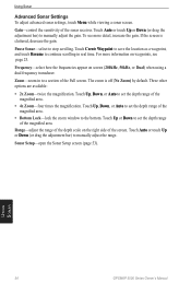
... the zoom window to set the depth range of the sonar receiver. Sonar Setup-open the Sonar Setup screen (page 53). For more detail, increase the gain. Using Sonar 54 GPSMAP 5000 Series Owner's Manual To see more information on screen (200kHz, 50kHz, or Dual) when using a dual frequency transducer. Zoom-zoom in real time. Touch Up, Down, or Auto to manually adjust the gain. Using Sonar Advanced Sonar Settings To adjust advanced sonar settings, touch Menu while viewing a sonar screen. Touch Auto or touch Up or...
... the zoom window to set the depth range of the sonar receiver. Sonar Setup-open the Sonar Setup screen (page 53). For more detail, increase the gain. Using Sonar 54 GPSMAP 5000 Series Owner's Manual To see more information on screen (200kHz, 50kHz, or Dual) when using a dual frequency transducer. Zoom-zoom in real time. Touch Up, Down, or Auto to manually adjust the gain. Using Sonar Advanced Sonar Settings To adjust advanced sonar settings, touch Menu while viewing a sonar screen. Touch Auto or touch Up or...
Owner's Manual
Page 59
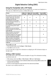
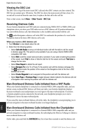
... you connect your radio is capable, GPS position information is now available in the DSC list. Quickly set up and send individual routine call from your chartplotter, the radio displays the Distress Call page to turn DSC on the radar screen. See page 58 for information on configuring how DSC information displays on or off . Feature The chartplotter can track the positions of the vessel and touch Done. DSC GPSMAP 5000 Series Owner's Manual 55 From the Home screen...
... you connect your radio is capable, GPS position information is now available in the DSC list. Quickly set up and send individual routine call from your chartplotter, the radio displays the Distress Call page to turn DSC on the radar screen. See page 58 for information on configuring how DSC information displays on or off . Feature The chartplotter can track the positions of the vessel and touch Done. DSC GPSMAP 5000 Series Owner's Manual 55 From the Home screen...
Owner's Manual
Page 60
... tracking the position of the vessel on the Navigation chart at the time a DSC distress call is connected to a Garmin NMEA 2000-compatible radio and you receive a DSC distress call: 1. If position information was sent with the call in distress (page 58). Touch Review to the man-overboard point. If your Garmin chartplotter displays the man-overboard screen and prompts you to navigate to 100 entries. If you have entered. The symbol marks...
... tracking the position of the vessel on the Navigation chart at the time a DSC distress call is connected to a Garmin NMEA 2000-compatible radio and you receive a DSC distress call: 1. If position information was sent with the call in distress (page 58). Touch Review to the man-overboard point. If your Garmin chartplotter displays the man-overboard screen and prompts you to navigate to 100 entries. If you have entered. The symbol marks...
Owner's Manual
Page 74
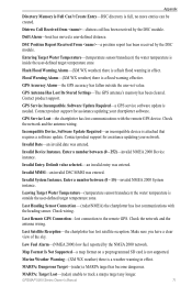
... within safe depth- (BlueChart g2 Vision) auto-guidance cannot calculate the route; Auto-guidance unable to calculate route. Can't Read Voltages That Low, Limited To Bottom Of Range-entering a battery alarm voltage lower than the chartplotter can read. Can't Write User Card-cannot write card when attempting a user data transfer. Alarm Clock-the alarm clock alarm has sounded. travel to Calibrate-(speed sensor) appears during water speed calibration. Software Update Required-a software update is a short in directory. 70 GPSMAP 5000 Series Owner's Manual Ending position not...
... within safe depth- (BlueChart g2 Vision) auto-guidance cannot calculate the route; Auto-guidance unable to calculate route. Can't Read Voltages That Low, Limited To Bottom Of Range-entering a battery alarm voltage lower than the chartplotter can read. Can't Write User Card-cannot write card when attempting a user data transfer. Alarm Clock-the alarm clock alarm has sounded. travel to Calibrate-(speed sensor) appears during water speed calibration. Software Update Required-a software update is a short in directory. 70 GPSMAP 5000 Series Owner's Manual Ending position not...
Owner's Manual
Page 75
...sensor/transducer) the water temperature is full, no more entries can be created. Lost Remote GPS Connection-lost communications with the remote GPS device. Check the network and the antenna wiring. Software Update Required-a GPS service software update is not supported. Invalid Date-an invalid date was entered. Map Format Is Not Supported-a map format on a preprogrammed SD card is needed. Invalid Entry. Lost Heading Sensor Connection- (radar/NMEA) the chartplotter has lost connection to track a marpa target any longer. Flash Flood Warning Alarm-(XM WX weather...
...sensor/transducer) the water temperature is full, no more entries can be created. Lost Remote GPS Connection-lost communications with the remote GPS device. Check the network and the antenna wiring. Software Update Required-a GPS service software update is not supported. Invalid Date-an invalid date was entered. Map Format Is Not Supported-a map format on a preprogrammed SD card is needed. Invalid Entry. Lost Heading Sensor Connection- (radar/NMEA) the chartplotter has lost connection to track a marpa target any longer. Flash Flood Warning Alarm-(XM WX weather...
Owner's Manual
Page 76
.... No Tracks Found-no proximity waypoints found while attempting a user data transfer. Not All Maps Fit, Some Maps Will Not Be Drawn-there are more maps present on the SD card than what the chartplotter can be listed to find map features. Off Course Alarm-the boat has left the user-defined course. Radar Guard Zone Alarm-(radar) an object has been detected in simulator mode. 72 GPSMAP 5000 Series Owner's Manual Radar Needs Repair Error Code-(radar) the radar needs repair. Software Update Required-a radar software update is...
.... No Tracks Found-no proximity waypoints found while attempting a user data transfer. Not All Maps Fit, Some Maps Will Not Be Drawn-there are more maps present on the SD card than what the chartplotter can be listed to find map features. Off Course Alarm-the boat has left the user-defined course. Radar Guard Zone Alarm-(radar) an object has been detected in simulator mode. 72 GPSMAP 5000 Series Owner's Manual Radar Needs Repair Error Code-(radar) the radar needs repair. Software Update Required-a radar software update is...
Owner's Manual
Page 80
... C calibrate water speed 40 category (XM) 42, 66 celestial information 31 change combination 22 channel entry (XM) 42, 66 channel guide (XM) 42, 66 chart fishing 6 chart appearance 11 charts appearance 11 borders 12 detail 11 fish eye 3D 6, 15 fishing 15 mariner's eye 6, 15 navigation 6 settings 11 using 6 clear user data 34 coastal observation stations 65 76 cold front 62 color mode adjusting 3 colors 17 sonar 53 combinations 21 communications settings 38 configure 36 course...
... C calibrate water speed 40 category (XM) 42, 66 celestial information 31 change combination 22 channel entry (XM) 42, 66 channel guide (XM) 42, 66 chart fishing 6 chart appearance 11 charts appearance 11 borders 12 detail 11 fish eye 3D 6, 15 fishing 15 mariner's eye 6, 15 navigation 6 settings 11 using 6 clear user data 34 coastal observation stations 65 76 cold front 62 color mode adjusting 3 colors 17 sonar 53 combinations 21 communications settings 38 configure 36 course...
Owner's Manual
Page 81
... north 37 U units of measure changing 37 user data clearing 32 transferring 33 viewing 32 user mag var 37 V video viewing 35 viewing currents 30 user data 32 visibility 64 Vision BlueChart g2 15 volume unit settings 37 VRM/EBL adjusting 49 W warm front 62 warnings county 61 marine 61 warranty 74 water speed (calibrate) 40 temperature 64 wave direction 62 height 63 period 62 waypoints 13 creating 10, 25 deleting 25, 26 edit...
... north 37 U units of measure changing 37 user data clearing 32 transferring 33 viewing 32 user mag var 37 V video viewing 35 viewing currents 30 user data 32 visibility 64 Vision BlueChart g2 15 volume unit settings 37 VRM/EBL adjusting 49 W warm front 62 warnings county 61 marine 61 warranty 74 water speed (calibrate) 40 temperature 64 wave direction 62 height 63 period 62 waypoints 13 creating 10, 25 deleting 25, 26 edit...
Installation Instructions
Page 1
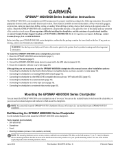
.... Go to -date (page 20). You can use the GPSMAP 4000/5000 chartplotter, this manual covers other installation options: • Connecting the chartplotter to other Garmin Marine Network compatible devices, such as a sounder or a radar (page 12). • Connecting the chartplotter to an existing NMEA 2000 network (page 10). • Connecting the chartplotter to the following instructions. GPSMAP® 4000/5000 Series Installation Instructions The GPSMAP 4000/5000 series chartplotter and GPS antenna must be properly installed according to other important information.
.... Go to -date (page 20). You can use the GPSMAP 4000/5000 chartplotter, this manual covers other installation options: • Connecting the chartplotter to other Garmin Marine Network compatible devices, such as a sounder or a radar (page 12). • Connecting the chartplotter to an existing NMEA 2000 network (page 10). • Connecting the chartplotter to the following instructions. GPSMAP® 4000/5000 Series Installation Instructions The GPSMAP 4000/5000 series chartplotter and GPS antenna must be properly installed according to other important information.
Installation Instructions
Page 10
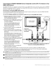
... power. If more information on the NMEA 2000 network. Caution: If you are using multiple chartplotters. 10 GPSMAP 4000/5000 Series Installation Instructions Note: One GPS antenna will not function. Disconnect one side of the T-connector you want to power or it will provide position data for every device on NMEA 2000, visit www.garmin.com. Note: The diagram shows only the NMEA 2000 data connection to an Existing NMEA 2000 Network 7. Route an included drop cable...
... power. If more information on the NMEA 2000 network. Caution: If you are using multiple chartplotters. 10 GPSMAP 4000/5000 Series Installation Instructions Note: One GPS antenna will not function. Disconnect one side of the T-connector you want to power or it will provide position data for every device on NMEA 2000, visit www.garmin.com. Note: The diagram shows only the NMEA 2000 data connection to an Existing NMEA 2000 Network 7. Route an included drop cable...

Installation Instructions
Page 11
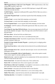
...using multiple chartplotters. Note: One GPS antenna will provide position data for the boat if possible. 4. To create a basic NMEA 2000 network 1. Connect the NMEA 2000 power cable to the GPSMAP 4000/5000 series chartplotter. GPSMAP 4000/5000 series chartplotter GPS 17x antenna Ignition or in-line switch Fuse Power cable + - 12 Vdc battery Female terminator Drop cables Male terminator T-connectors Creating a Basic NMEA 2000 Network Note: The diagram shows only the NMEA 2000 data connection to the top of one of the T-connectors. 5. Wire the included NMEA 2000 power cable...
...using multiple chartplotters. Note: One GPS antenna will provide position data for the boat if possible. 4. To create a basic NMEA 2000 network 1. Connect the NMEA 2000 power cable to the GPSMAP 4000/5000 series chartplotter. GPSMAP 4000/5000 series chartplotter GPS 17x antenna Ignition or in-line switch Fuse Power cable + - 12 Vdc battery Female terminator Drop cables Male terminator T-connectors Creating a Basic NMEA 2000 Network Note: The diagram shows only the NMEA 2000 data connection to the top of one of the T-connectors. 5. Wire the included NMEA 2000 power cable...
Installation Instructions
Page 16
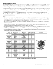
... the WPL sentence, DSC, and sonar NMEA 0183 input with support for the DPT (depth) or DBT, MTW (water temperature), and VHW (water temperature, speed, and heading) sentences. • Use the Communications section of each TX port to receive data from the GPSMAP 4000/5000 series chartplotter and your NMEA 0183-compliant device to identify the Transfer (TX) A(+) and B(-) wires and Receiving (RX) A(+) and B(-) wires. Connect the corresponding A (+) and B (-) wires of the Configure menu on Ground spare Wire Color White Orange...
... the WPL sentence, DSC, and sonar NMEA 0183 input with support for the DPT (depth) or DBT, MTW (water temperature), and VHW (water temperature, speed, and heading) sentences. • Use the Communications section of each TX port to receive data from the GPSMAP 4000/5000 series chartplotter and your NMEA 0183-compliant device to identify the Transfer (TX) A(+) and B(-) wires and Receiving (RX) A(+) and B(-) wires. Connect the corresponding A (+) and B (-) wires of the Configure menu on Ground spare Wire Color White Orange...


