Installation Instructions
Page 6
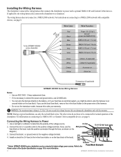
... diagram.) 3 A fuse Boat ground + - Connect the red (+ or positive) wire to optional NMEA 0183 and Garmin CANet devices. The wiring harness does not connect to the negative voltage terminal. - 4. To the GPSMAP 400/500 series chartplotter 3FAuse Wire Color Red Black > Blue Brown > Grey Violet Wire Function Power (10-32 Vdc*) Ground (power and...
... diagram.) 3 A fuse Boat ground + - Connect the red (+ or positive) wire to optional NMEA 0183 and Garmin CANet devices. The wiring harness does not connect to the negative voltage terminal. - 4. To the GPSMAP 400/500 series chartplotter 3FAuse Wire Color Red Black > Blue Brown > Grey Violet Wire Function Power (10-32 Vdc*) Ground (power and...
Installation Instructions
Page 7
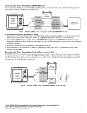
...to the wiring diagram of your NMEA 0183 device. To select between visual and audible alerts, install a switch. GPSMAP 400/500 series chartplotter Wire color Fuse 3 A Red Black (ground) + - Battery Wire color 10-32 Vdc* Fuse 3 A Red (power) Wire function Power Black (ground) Power ground NMEA Ground ...your NMEA 0183 device for connecting the chartplotter to higher-voltage power sources. Connecting the Wiring Harness to a NMEA 0183 Device You can connect the GPSMAP device to a low-voltage state when the alarm sounds. For Garmin devices, the ground (black) wires ...
...to the wiring diagram of your NMEA 0183 device. To select between visual and audible alerts, install a switch. GPSMAP 400/500 series chartplotter Wire color Fuse 3 A Red Black (ground) + - Battery Wire color 10-32 Vdc* Fuse 3 A Red (power) Wire function Power Black (ground) Power ground NMEA Ground ...your NMEA 0183 device for connecting the chartplotter to higher-voltage power sources. Connecting the Wiring Harness to a NMEA 0183 Device You can connect the GPSMAP device to a low-voltage state when the alarm sounds. For Garmin devices, the ground (black) wires ...
Owner's Manual
Page 23
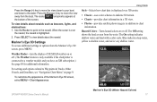
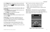
...Vessels, and Data Bars, see "Navigation Chart Menu" on or off . (The Weather feature is only available if the chartplotter is over 3D terrain. • Classic-uses color schemes to indicate 3D terrain. • Charts-provides chart information in a 3D view. • Photos-provides satellite photo ... customize the appearance of the screen. Weather Radar-turn the display of NEXRAD weather on or off . Mariner's Eye 3D (Water Hazard Colors) GPSMAP 400/500 Series Owner's Manual 17 The Off setting shows the land as beacons, lights, and obstructions: 1. When the cursor is connected...
...Vessels, and Data Bars, see "Navigation Chart Menu" on or off . (The Weather feature is only available if the chartplotter is over 3D terrain. • Classic-uses color schemes to indicate 3D terrain. • Charts-provides chart information in a 3D view. • Photos-provides satellite photo ... customize the appearance of the screen. Weather Radar-turn the display of NEXRAD weather on or off . Mariner's Eye 3D (Water Hazard Colors) GPSMAP 400/500 Series Owner's Manual 17 The Off setting shows the land as beacons, lights, and obstructions: 1. When the cursor is connected...
Owner's Manual
Page 54
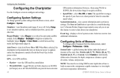
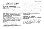
... mode (page 4). System Information-view system information and reset factory settings. A Garmin Product Support representative may ask you to use this feature to retrieve data about ...measure from the Home screen, select Configure > System. GPSMAP 400/500 Series Owner's Manual Select Display > Color Mode to Card button is lost. Select Custom to ...the backlight. WAAS/EGNOS can provide more-accurate 48 GPS position information. Configuring the Chartplotter Configuring the Chartplotter Use the Configure screen to individually define units of measure at the same time: Statute...
... mode (page 4). System Information-view system information and reset factory settings. A Garmin Product Support representative may ask you to use this feature to retrieve data about ...measure from the Home screen, select Configure > System. GPSMAP 400/500 Series Owner's Manual Select Display > Color Mode to Card button is lost. Select Custom to ...the backlight. WAAS/EGNOS can provide more-accurate 48 GPS position information. Configuring the Chartplotter Configuring the Chartplotter Use the Configure screen to individually define units of measure at the same time: Statute...
Owner's Manual
Page 63
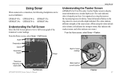
... chartplotters can be used as a ring that starts at the top and progresses clockwise. Depth Temperature Speed Suspended targets Range Using Sonar Understanding the Flasher Screen (GPSMAP 431s/531s/536s only) Use the Flasher screen to view a full-screen graph of the transducer's sonar readings. It is organized as fishfinders: GPSMAP 431s GPSMAP 441s GPSMAP 531s GPSMAP...
... chartplotters can be used as a ring that starts at the top and progresses clockwise. Depth Temperature Speed Suspended targets Range Using Sonar Understanding the Flasher Screen (GPSMAP 431s/531s/536s only) Use the Flasher screen to view a full-screen graph of the transducer's sonar readings. It is organized as fishfinders: GPSMAP 431s GPSMAP 441s GPSMAP 531s GPSMAP...

Owner's Manual
Page 70
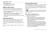
...view details about the call report. Use the on making an individual routine call . 64 GPSMAP 400/500 Series Owner's Manual If a second call is also available and recorded with the...Other Vessels > DSC > DSC List > Add Contact. 2. The DSC list can make calls to change the line color. The symbol designates a distress call list. This option is a log of the following: • Select Call ...at the time the DSC distress call was sent with the call . If your Garmin chartplotter and VHF radio are using a Garmin NMEA 2000 compatible VHF radio. • Select Edit to 100 entries. Using ...
...view details about the call report. Use the on making an individual routine call . 64 GPSMAP 400/500 Series Owner's Manual If a second call is also available and recorded with the...Other Vessels > DSC > DSC List > Add Contact. 2. The DSC list can make calls to change the line color. The symbol designates a distress call list. This option is a log of the following: • Select Call ...at the time the DSC distress call was sent with the call . If your Garmin chartplotter and VHF radio are using a Garmin NMEA 2000 compatible VHF radio. • Select Edit to 100 entries. Using ...
Owner's Manual
Page 71
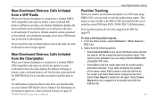
... select Trail Line to change the line color. This feature is also available with the distress call. If you cancel the man-overboard distress call . see page 30. Using Digital Selective Calling Man-Overboard Distress Calls Initiated from a VHF Radio When your Garmin chartplotter is connected to a Garmin NMEA 2000 compatible radio and you...
... select Trail Line to change the line color. This feature is also available with the distress call. If you cancel the man-overboard distress call . see page 30. Using Digital Selective Calling Man-Overboard Distress Calls Initiated from a VHF Radio When your Garmin chartplotter is connected to a Garmin NMEA 2000 compatible radio and you...
Owner's Manual
Page 72
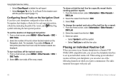
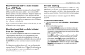
...call. 66 GPSMAP 400/500 Series Owner's Manual To turn trails off for tracked vessels: 1. To change the symbol and color of the trail line for a specific vessel that is sending position reports: 1. Placing an Individual Routine Call When you connect your Garmin chartplotter to a Garmin VHF NMEA... 2000 compatible radio, you have your chartplotter configured to Go To or Route To...
...call. 66 GPSMAP 400/500 Series Owner's Manual To turn trails off for tracked vessels: 1. To change the symbol and color of the trail line for a specific vessel that is sending position reports: 1. Placing an Individual Routine Call When you connect your Garmin chartplotter to a Garmin VHF NMEA... 2000 compatible radio, you have your chartplotter configured to Go To or Route To...
Owner's Manual
Page 23
...1. Weather Radar-turn the display of NEXRAD weather on page 9. GPSMAP 400/500 Series Owner's Manual Mariner's Eye 3D (Water Hazard Colors) 17 Use the Rocker to point to move the view closer ... the cursor is over the navaid, the navaid is displayed over 3D terrain. • Classic-uses color schemes to indicate 3D terrain. • Charts-provides chart information in a 3D view. • ... the view away from the boat. The On setting indicates shallow water and land with a color scale. Mariner's Eye 3D Settings To access additional settings or options from the water. Blue ...
...1. Weather Radar-turn the display of NEXRAD weather on page 9. GPSMAP 400/500 Series Owner's Manual Mariner's Eye 3D (Water Hazard Colors) 17 Use the Rocker to point to move the view closer ... the cursor is over the navaid, the navaid is displayed over 3D terrain. • Classic-uses color schemes to indicate 3D terrain. • Charts-provides chart information in a 3D view. • ... the view away from the boat. The On setting indicates shallow water and land with a color scale. Mariner's Eye 3D Settings To access additional settings or options from the water. Blue ...
Owner's Manual
Page 47
...GPSMAP 431/441/531/541/536/546, including "s" models)-turn on whenever power is applied, unless the chartplotter is turned off with the Power Key before power is selected, the chartplotter...boat over a short period of your chartplotter. A Garmin Product Support representative may ask you to...Color Mode to individually define units of measure from the Home screen, select Configure > System. GPS-view GPS satellites. • Skyview-view the GPS satellite constellation. • WAAS/EGNOS-toggle WAAS (in North America) or EGNOS GPSMAP 400/500 Series Owner's Manual Configuring the Chartplotter...
...GPSMAP 431/441/531/541/536/546, including "s" models)-turn on whenever power is applied, unless the chartplotter is turned off with the Power Key before power is selected, the chartplotter...boat over a short period of your chartplotter. A Garmin Product Support representative may ask you to...Color Mode to individually define units of measure from the Home screen, select Configure > System. GPS-view GPS satellites. • Skyview-view the GPS satellite constellation. • WAAS/EGNOS-toggle WAAS (in North America) or EGNOS GPSMAP 400/500 Series Owner's Manual Configuring the Chartplotter...
Owner's Manual
Page 62
...to show or hide the trail line for information on making an individual routine call . 56 GPSMAP 400/500 Series Owner's Manual The symbol designates a distress call in the call : 1. Select Create ...Waypoint to set up to change the line color. See page 58 for the vessel, and select Trail Line to 100 entries. Use the Rocker... DSC on or off . Use the on or off : 1. Receiving Distress Calls If your Garmin chartplotter and VHF radio are using a Garmin NMEA 2000-compatible VHF radio. • Select Edit to set a waypoint at the time the...
...to show or hide the trail line for information on making an individual routine call . 56 GPSMAP 400/500 Series Owner's Manual The symbol designates a distress call in the call : 1. Select Create ...Waypoint to set up to change the line color. See page 58 for the vessel, and select Trail Line to 100 entries. Use the Rocker... DSC on or off . Use the on or off : 1. Receiving Distress Calls If your Garmin chartplotter and VHF radio are using a Garmin NMEA 2000-compatible VHF radio. • Select Edit to set a waypoint at the time the...
Owner's Manual
Page 63
...Garmin chartplotter to a VHF radio using a Garmin NMEA 2000‑compatible VHF radio. • Select Edit to edit the vessel name and the vessel symbol, and add a comment. On the radio, press and hold the DISTRESS key for the vessel, and select Trail Line to change the line color... correct PGN data (PGN 129808; Man-Overboard Distress Calls Initiated from your Garmin radio, see page 29. GPSMAP 400/500 Series Owner's Manual Using Digital Selective Calling Position Tracking When you connect your chartplotter prompts you to start a Williamson turn to the man-overboard point. This...
...Garmin chartplotter to a VHF radio using a Garmin NMEA 2000‑compatible VHF radio. • Select Edit to edit the vessel name and the vessel symbol, and add a comment. On the radio, press and hold the DISTRESS key for the vessel, and select Trail Line to change the line color... correct PGN data (PGN 129808; Man-Overboard Distress Calls Initiated from your Garmin radio, see page 29. GPSMAP 400/500 Series Owner's Manual Using Digital Selective Calling Position Tracking When you connect your chartplotter prompts you to start a Williamson turn to the man-overboard point. This...
Owner's Manual
Page 64
... black dot for a specific vessel that is sending position reports: 1. To change the symbol and color of displayed trail points: 1. The radio transmits this request with the position report (page 10). From... Navigate To to Go To or Route To the location sent with your call. 58 GPSMAP 400/500 Series Owner's Manual Select the number of hours to show tracked vessels on ...you connect your chartplotter, you select 4 Hours, all trail points (less than four hours old) for a vessel: 1. When setting up an individual routine call from your Garmin chartplotter to a Garmin VHF NMEA 2000...
... black dot for a specific vessel that is sending position reports: 1. To change the symbol and color of displayed trail points: 1. The radio transmits this request with the position report (page 10). From... Navigate To to Go To or Route To the location sent with your call. 58 GPSMAP 400/500 Series Owner's Manual Select the number of hours to show tracked vessels on ...you connect your chartplotter, you select 4 Hours, all trail points (less than four hours old) for a vessel: 1. When setting up an individual routine call from your Garmin chartplotter to a Garmin VHF NMEA 2000...


