Yoke Mount Instructions
Page 1
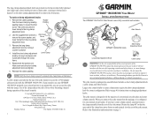
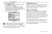
... column controls. or its subsidiaries Garmin International, Inc. 1200 East 151st Street, Olathe, Kansas 66062, U.S.A. Garmin (Europe) Ltd. B 4 GPSMAP 196/296/396 YOKE MOUNT INSTALLATION INSTRUCTIONS The GPSMAP 196/296/396 Yoke Mount comes fully assembled and includes: Allen Wrench GPSMAP 196/296/396 Cradle Short Clamp Adjustment...the screw, washer, and Allen Head Screw lower clamp from the rest of the aircraft controls. © Copyright 2005 Garmin Ltd. Do not mount the GPSMAP 196/296/396 in a place where the pilot or passengers are likely to page 4 for instructions on page 3. 1...
... column controls. or its subsidiaries Garmin International, Inc. 1200 East 151st Street, Olathe, Kansas 66062, U.S.A. Garmin (Europe) Ltd. B 4 GPSMAP 196/296/396 YOKE MOUNT INSTALLATION INSTRUCTIONS The GPSMAP 196/296/396 Yoke Mount comes fully assembled and includes: Allen Wrench GPSMAP 196/296/396 Cradle Short Clamp Adjustment...the screw, washer, and Allen Head Screw lower clamp from the rest of the aircraft controls. © Copyright 2005 Garmin Ltd. Do not mount the GPSMAP 196/296/396 in a place where the pilot or passengers are likely to page 4 for instructions on page 3. 1...

Pilot's Guide
Page 3
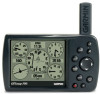
... detail, the main pages and features in Land Mode, such as the E6B. GPSMAP 196 Pilot's Guide i The Basic Operation in Water Mode section provides you with information about some of Garmin GPS and full-featured mapping. The Appendix contains specifications, optional accessories, .... An Index is provided at the end of the manual for your Garmin dealer immediately. It may result in minor injury or property damage. INTRODUCTION Thank you for choosing the Garmin GPSMAP® 196, an unsurpassed portable aviation receiver that utilizes the proven performance of the ...
... detail, the main pages and features in Land Mode, such as the E6B. GPSMAP 196 Pilot's Guide i The Basic Operation in Water Mode section provides you with information about some of Garmin GPS and full-featured mapping. The Appendix contains specifications, optional accessories, .... An Index is provided at the end of the manual for your Garmin dealer immediately. It may result in minor injury or property damage. INTRODUCTION Thank you for choosing the Garmin GPSMAP® 196, an unsurpassed portable aviation receiver that utilizes the proven performance of the ...
Pilot's Guide
Page 6
... enter destinations, change settings, or access any questions or would like additional information, refer to our Web site at http://www.garmin.com/prop65. Use obstacle data only as an aid for VFR navigation. If you have any functions requiring prolonged use voice prompts...harm. INTRODUCTION > WARNING Warning Failure to avoid the following potentially hazardous situations could result in an accident or collision resulting in the GPSMAP 196 only to facilitate, not to replace, the use of authorized government charts. When navigating, carefully compare information shown on the vehicle ...
... enter destinations, change settings, or access any questions or would like additional information, refer to our Web site at http://www.garmin.com/prop65. Use obstacle data only as an aid for VFR navigation. If you have any functions requiring prolonged use voice prompts...harm. INTRODUCTION > WARNING Warning Failure to avoid the following potentially hazardous situations could result in an accident or collision resulting in the GPSMAP 196 only to facilitate, not to replace, the use of authorized government charts. When navigating, carefully compare information shown on the vehicle ...

Pilot's Guide
Page 7
...operated by the United States government, which is available to the consumer. We use the GPSMAP 196 for any navigation device can be used to some extent. GPSMAP 196 Pilot's Guide v Caution INTRODUCTION > CAUTION Failure to avoid the following potentially hazardous situations ... provide customers with route suggestions. Although the GPSMAP 196 is a precision navigation device, any purpose requiring precise measurement of governmental and private data sources, which could affect the accuracy and performance of Garmin is either not available or prohibitively expensive. Virtually...
...operated by the United States government, which is available to the consumer. We use the GPSMAP 196 for any navigation device can be used to some extent. GPSMAP 196 Pilot's Guide v Caution INTRODUCTION > CAUTION Failure to avoid the following potentially hazardous situations ... provide customers with route suggestions. Although the GPSMAP 196 is a precision navigation device, any purpose requiring precise measurement of governmental and private data sources, which could affect the accuracy and performance of Garmin is either not available or prohibitively expensive. Virtually...
Pilot's Guide
Page 8
... user maintenance other than cleaning. It can occur (such as in the U.S.A. Prolonged submersion can cause damage to the unit. vi GPSMAP 196 Pilot's Guide Clean the unit using this guide, contact Garmin Product Support in the trunk of a car) as waypoints and routes, is constructed of water for external power. Immersing the...
... user maintenance other than cleaning. It can occur (such as in the U.S.A. Prolonged submersion can cause damage to the unit. vi GPSMAP 196 Pilot's Guide Clean the unit using this guide, contact Garmin Product Support in the trunk of a car) as waypoints and routes, is constructed of water for external power. Immersing the...
Pilot's Guide
Page 18
...most character field and press left to move back to the Garmin Web site at http://www.garmin.com/cartography/ 10 GPSMAP 196 Pilot's Guide You also should update your GPSMAP 196. MapSource Detailed Maps Optional Garmin Data Cards and MapSource CD-ROMs enhance the versatility of your Jeppesen ... view listings of data, keep pressing right to drop to the optional Data Card. Refer to select characters. GETTING STARTED > USING THE GPSMAP 196 To enter data in the "Appendix" for any listed location. Press up or down on the ROCKER. If there are programmable. After...
...most character field and press left to move back to the Garmin Web site at http://www.garmin.com/cartography/ 10 GPSMAP 196 Pilot's Guide You also should update your GPSMAP 196. MapSource Detailed Maps Optional Garmin Data Cards and MapSource CD-ROMs enhance the versatility of your Jeppesen ... view listings of data, keep pressing right to drop to the optional Data Card. Refer to select characters. GETTING STARTED > USING THE GPSMAP 196 To enter data in the "Appendix" for any listed location. Press up or down on the ROCKER. If there are programmable. After...
Pilot's Guide
Page 50
...://www.garmin.com/aviation. If you land and groundspeed drops below 30 knots, the flight entry is saved and a new entry is recorded when you gain 500 feet of the page and change the data fields. Reset Max Speed-clears the maximum speed. The GPSMAP 196 saves ... the nearest airport as your speed exceeds 30 knots and you depart the airport. The destination airport is available to view additional information. 42 GPSMAP 196 Pilot's Guide Select any recorded flights, including date, route of the following options: Reset Trip-clears trip information, except the maximum ...
...://www.garmin.com/aviation. If you land and groundspeed drops below 30 knots, the flight entry is saved and a new entry is recorded when you gain 500 feet of the page and change the data fields. Reset Max Speed-clears the maximum speed. The GPSMAP 196 saves ... the nearest airport as your speed exceeds 30 knots and you depart the airport. The destination airport is available to view additional information. 42 GPSMAP 196 Pilot's Guide Select any recorded flights, including date, route of the following options: Reset Trip-clears trip information, except the maximum ...

Pilot's Guide
Page 103
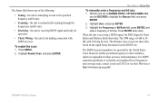
...north heading references based on the variation you want. WARNING: If User Mag Var is used in conjunction with a PC or another Garmin GPSMAP 196. Failure to specify the magnetic variation at your present location. To open the Interface sub tab, press MENU twice to external devices.... to one of your current location in the Magnetic Variation field if you have selected User Mag Var for the heading. GPSMAP 196 Pilot's Guide 95 Selecting a Different Heading Reference You can result in substantial differences between the information shown on your unit and external...
...north heading references based on the variation you want. WARNING: If User Mag Var is used in conjunction with a PC or another Garmin GPSMAP 196. Failure to specify the magnetic variation at your present location. To open the Interface sub tab, press MENU twice to external devices.... to one of your current location in the Magnetic Variation field if you have selected User Mag Var for the heading. GPSMAP 196 Pilot's Guide 95 Selecting a Different Heading Reference You can result in substantial differences between the information shown on your unit and external...
Pilot's Guide
Page 104
... text data that includes, data, time, location, and velocity. If you select GARMIN DGPS or RTCM In/NMEA Out format, you use the ROCKER to highlight the Beacon field, and press ENTER. 2. Allows the GPSMAP 196 to show a Goto or route selected on both units. • RTCM In-...press ENTER. With the unit set to 1200, 2400, 4800, or 9600. • None-provides no interfacing capabilities. MAIN MENU > SETUP TAB • GARMIN DGPS-used to connect the GPSMAP 196 with GARMIN DGPS selected 96 GPSMAP 196 Pilot's Guide You can have the unit automatically scan for connection to...
... text data that includes, data, time, location, and velocity. If you select GARMIN DGPS or RTCM In/NMEA Out format, you use the ROCKER to highlight the Beacon field, and press ENTER. 2. Allows the GPSMAP 196 to show a Goto or route selected on both units. • RTCM In-...press ENTER. With the unit set to 1200, 2400, 4800, or 9600. • None-provides no interfacing capabilities. MAIN MENU > SETUP TAB • GARMIN DGPS-used to connect the GPSMAP 196 with GARMIN DGPS selected 96 GPSMAP 196 Pilot's Guide You can have the unit automatically scan for connection to...
Pilot's Guide
Page 105
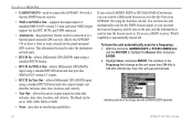
...; Check Wiring-the unit is receiving a DGPS signal, the SNR (Signal to highlight the Beacon field, and press ENTER. 2. With the unit set to GARMIN DGPS or RTCM In/NMEA Out, use the ROCKER to Noise Ratio) and Distance fields show data, based on the signal being the best... http://www.navcen.uscg.mil/. Highlight the Frequency or Bit Rate field, press ENTER, and enter a frequency or bit rate. Press ENTER when done. GPSMAP 196 Pilot's Guide 97
...; Check Wiring-the unit is receiving a DGPS signal, the SNR (Signal to highlight the Beacon field, and press ENTER. 2. With the unit set to GARMIN DGPS or RTCM In/NMEA Out, use the ROCKER to Noise Ratio) and Distance fields show data, based on the signal being the best... http://www.navcen.uscg.mil/. Highlight the Frequency or Bit Rate field, press ENTER, and enter a frequency or bit rate. Press ENTER when done. GPSMAP 196 Pilot's Guide 97

Pilot's Guide
Page 106
...and press ENTER. Use the ROCKER to names or numbers, as well as a radar or autopilot), the unit needs to be customized to interface the GPSMAP 196 with another piece of tabs along the top. 4. Select Interface from the vertical tab list. 3. Highlight the field below Serial Data Format. ... can be set Waypoint IDs to select Setup from the row of equipment (such as turn on and off the GPS status, the GARMIN Proprietary sentences, and Waypoint/Route (WPL, RTE). 98 GPSMAP 196 Pilot's Guide To access the Advanced NMEA Output Setup: 1. Select NMEA In/NMEA Out.
...and press ENTER. Use the ROCKER to names or numbers, as well as a radar or autopilot), the unit needs to be customized to interface the GPSMAP 196 with another piece of tabs along the top. 4. Select Interface from the vertical tab list. 3. Highlight the field below Serial Data Format. ... can be set Waypoint IDs to select Setup from the row of equipment (such as turn on and off the GPS status, the GARMIN Proprietary sentences, and Waypoint/Route (WPL, RTE). 98 GPSMAP 196 Pilot's Guide To access the Advanced NMEA Output Setup: 1. Select NMEA In/NMEA Out.
Pilot's Guide
Page 108
... unit to protect the screen from MapSource CD-ROMs to a data card, either Garmin BlueChart or Fishing Hot Spots map data. 100 GPSMAP 196 Pilot's Guide Carrying Case-Protects the GPSMAP 196 when not in an automobile. MapSource Software CD-ROMs-Offers several detailed mapping options ...Interface Cable (with a Serial connector), or with storage for using the bare wires. WARNING: Garmin accessories have not been tested or approved for use the GPSMAP 196 in use with Garmin products. Permanent and Temporary Adhesive Disks-Adhesive disks for data cards. Download detailed map data from...
... unit to protect the screen from MapSource CD-ROMs to a data card, either Garmin BlueChart or Fishing Hot Spots map data. 100 GPSMAP 196 Pilot's Guide Carrying Case-Protects the GPSMAP 196 when not in an automobile. MapSource Software CD-ROMs-Offers several detailed mapping options ...Interface Cable (with a Serial connector), or with storage for using the bare wires. WARNING: Garmin accessories have not been tested or approved for use the GPSMAP 196 in use with Garmin products. Permanent and Temporary Adhesive Disks-Adhesive disks for data cards. Download detailed map data from...

Pilot's Guide
Page 110
... slot on , a confirmation tone sounds when the data card has been removed. 102 GPSMAP 196 Pilot's Guide APPENDIX > INSTALLATION INFORMATION Installing and Removing Data Cards The GPSMAP 196 uses an optional Garmin data card to force the card. The handle is properly inserted. 3. To remove a data card...appears. If the unit is still not recognized, contact Garmin Product Support or your data card, such as BlueChart and MapSource detailed maps in a MapSource program. Install the data card in the case supplied with your GPSMAP 196. You can load a variety of the unit. Data...
... slot on , a confirmation tone sounds when the data card has been removed. 102 GPSMAP 196 Pilot's Guide APPENDIX > INSTALLATION INFORMATION Installing and Removing Data Cards The GPSMAP 196 uses an optional Garmin data card to force the card. The handle is properly inserted. 3. To remove a data card...appears. If the unit is still not recognized, contact Garmin Product Support or your data card, such as BlueChart and MapSource detailed maps in a MapSource program. Install the data card in the case supplied with your GPSMAP 196. You can load a variety of the unit. Data...
Pilot's Guide
Page 111
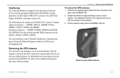
...instructions that came with an external antenna. APPENDIX > INSTALLATION INFORMATION To remove the GPS antenna: 1. Removing the GPS Antenna GPSMAP 196 Pilot's Guide 103 Interfacing The following are supported for the GPGSA, GPGSV, GPWPL, GPRTE. Proprietary sentences - You can remove... the connector on the back of external devices: Garmin proprietary Differential GPS (DGPS), Garmin proprietary aviation input, NMEA 0183 (versions 3.0), ASCII Text Output, RTCM SC-104 input (version 2.0). Pull the antenna away from the GPSMAP 196 unit. The following formats are the sentences for...
...instructions that came with an external antenna. APPENDIX > INSTALLATION INFORMATION To remove the GPS antenna: 1. Removing the GPS Antenna GPSMAP 196 Pilot's Guide 103 Interfacing The following are supported for the GPGSA, GPGSV, GPWPL, GPRTE. Proprietary sentences - You can remove... the connector on the back of external devices: Garmin proprietary Differential GPS (DGPS), Garmin proprietary aviation input, NMEA 0183 (versions 3.0), ASCII Text Output, RTCM SC-104 input (version 2.0). Pull the antenna away from the GPSMAP 196 unit. The following formats are the sentences for...

Pilot's Guide
Page 112
... without a fee, but in the 1980s, the government made up Differential GPS (DGPS) stations to navigate them. There are operational in your Garmin GPS is needed to the United States Coast Guard's Web site (http://www. Location-an exact, unique location based on the Main Menu or... and the receiver is searching for WAAS signal. • Using WAAS-WAAS capability is enabled and the unit is receiving WAAS corrections. 104 GPSMAP 196 Pilot's Guide The United States and Canadian governments (among others) have set up of a network of 24 satellites placed into the GPS receiver...
... without a fee, but in the 1980s, the government made up Differential GPS (DGPS) stations to navigate them. There are operational in your Garmin GPS is needed to the United States Coast Guard's Web site (http://www. Location-an exact, unique location based on the Main Menu or... and the receiver is searching for WAAS signal. • Using WAAS-WAAS capability is enabled and the unit is receiving WAAS corrections. 104 GPSMAP 196 Pilot's Guide The United States and Canadian governments (among others) have set up of a network of 24 satellites placed into the GPS receiver...

Pilot's Guide
Page 113
Two master stations, located on your Garmin GPS receiver, the receiver automatically uses the method that provided by ground stations may not improve accuracy, ...Currently, enabling WAAS on your GPS unit with increased accuracy at any operational SBAS system should be several services of providing your Garmin GPSMAP 196 in North America. • Check Beacon Wiring-the DGPS setting is enabled in the Interface sub tab on the Main Menu ...of the continental United States and portions of the GPS signal and increase location accuracy for an available frequency. GPSMAP 196 Pilot's Guide 105
Two master stations, located on your Garmin GPS receiver, the receiver automatically uses the method that provided by ground stations may not improve accuracy, ...Currently, enabling WAAS on your GPS unit with increased accuracy at any operational SBAS system should be several services of providing your Garmin GPSMAP 196 in North America. • Check Beacon Wiring-the DGPS setting is enabled in the Interface sub tab on the Main Menu ...of the continental United States and portions of the GPS signal and increase location accuracy for an available frequency. GPSMAP 196 Pilot's Guide 105

Pilot's Guide
Page 115
..., highlight the Location Format field, and press ENTER. Because of this, the unit can navigate to memory or using the ROCKER, and press ENTER. 7. GPSMAP 196 Pilot's Guide 107 Then select Location from the Main Menu: 1. To change the settings of any of the five fields, highlight the fi... that the GPS is not relying on the LORAN signal for navigation. For more information read our LORAN TD Position Format Handbook, available at the Garmin Web site, at www.garmin.com/support/userManual.html. To set up Loran TD from the row of horizontal tabs. 3.
..., highlight the Location Format field, and press ENTER. Because of this, the unit can navigate to memory or using the ROCKER, and press ENTER. 7. GPSMAP 196 Pilot's Guide 107 Then select Location from the Main Menu: 1. To change the settings of any of the five fields, highlight the fi... that the GPS is not relying on the LORAN signal for navigation. For more information read our LORAN TD Position Format Handbook, available at the Garmin Web site, at www.garmin.com/support/userManual.html. To set up Loran TD from the row of horizontal tabs. 3.

Pilot's Guide
Page 116
...different maps and charts use with other grids, including a user-definable grid (for download at http://www.garmin.com/manuals/UsingaGarminGP SwithPaperLandMaps_Manual.pdf. 108 GPSMAP 196 Pilot's Guide APPENDIX > MAP DATUMS AND LOCATION FORMATS Map Datums and Location Formats If you are referenced to Using... a Garmin GPS with Paper Land Maps, available for the advanced user), are available. Every chart has a map datum reference and the GPSMAP 196 can be carried out in a consistent and accurate manner. What ...
...different maps and charts use with other grids, including a user-definable grid (for download at http://www.garmin.com/manuals/UsingaGarminGP SwithPaperLandMaps_Manual.pdf. 108 GPSMAP 196 Pilot's Guide APPENDIX > MAP DATUMS AND LOCATION FORMATS Map Datums and Location Formats If you are referenced to Using... a Garmin GPS with Paper Land Maps, available for the advanced user), are available. Every chart has a map datum reference and the GPSMAP 196 can be carried out in a consistent and accurate manner. What ...

Pilot's Guide
Page 117
.... * Symbology used on Windows®-compatible PCs and requires the included PC Interface Cable to connect your GPSMAP 196 to create a new route with your flight record keeping. Visit the Garmin Web site at http://www.garmin.com/aviation. 109 NDBs-* identifier, facility name, city/state/country, location (latitude/longitude), and...
.... * Symbology used on Windows®-compatible PCs and requires the included PC Interface Cable to connect your GPSMAP 196 to create a new route with your flight record keeping. Visit the Garmin Web site at http://www.garmin.com/aviation. 109 NDBs-* identifier, facility name, city/state/country, location (latitude/longitude), and...
Pilot's Guide
Page 123
...LICENSE AGREEMENT AND WARRANTY Products sold through an online auction. The unit should then be free from Garmin. Garmin International, Inc. 1200 E 151st Street, Olathe, Kansas 66062 U.S.A. GPSMAP 196 Pilot's Guide 115 Garmin will not replace missing components from any way will at its sole option repair or replace any ... to open the case to change or modify the unit in normal use. Tel. 44/0870.8501241 Fax 44/0870.8501251 The Garmin GPSMAP 196 has no charge to the customer for warranty repairs. A copy of purchase for parts or labor, provided that fail in any package...
...LICENSE AGREEMENT AND WARRANTY Products sold through an online auction. The unit should then be free from Garmin. Garmin International, Inc. 1200 E 151st Street, Olathe, Kansas 66062 U.S.A. GPSMAP 196 Pilot's Guide 115 Garmin will not replace missing components from any way will at its sole option repair or replace any ... to open the case to change or modify the unit in normal use. Tel. 44/0870.8501241 Fax 44/0870.8501251 The Garmin GPSMAP 196 has no charge to the customer for warranty repairs. A copy of purchase for parts or labor, provided that fail in any package...


