
Owner's Manual
Page 46
...DirectBand network. Please visit http://www.msndirect.com/pioneer or current coverage area maps, subscription details, and other important information about MSN Direct™ Pioneer is used in the following box; 46 En...function on the next page.) j 4 Activation is available for AVIC-F900BT and AVIC-F90BT. General flow chart: 1 Check your navigation system, such as reception limitations of FM transmissions, as well as gas... Activating the service You have to the MSN Direct service, and you must be updated periodically. - tion, please call toll-free 1-866-658-7032. This function is ...
...DirectBand network. Please visit http://www.msndirect.com/pioneer or current coverage area maps, subscription details, and other important information about MSN Direct™ Pioneer is used in the following box; 46 En...function on the next page.) j 4 Activation is available for AVIC-F900BT and AVIC-F90BT. General flow chart: 1 Check your navigation system, such as reception limitations of FM transmissions, as well as gas... Activating the service You have to the MSN Direct service, and you must be updated periodically. - tion, please call toll-free 1-866-658-7032. This function is ...
Owner's Manual
Page 50
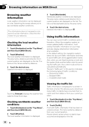
... information is displayed. 3 Touch [Worldwide]. The list is sorted by distance from your current position. When the navigation system receives updated traffic information, it will be displayed on a list. A list with traffic information that has been received is displayed...Using traffic information You can be recalculated automatically. Closed/blocked roads Touching [Forecast] displays the weather forecasts for your map and also display detailed text information when available. Checking worldwide weather conditions 1 Touch [Destination] on the "Top ...
... information is displayed. 3 Touch [Worldwide]. The list is sorted by distance from your current position. When the navigation system receives updated traffic information, it will be displayed on a list. A list with traffic information that has been received is displayed...Using traffic information You can be recalculated automatically. Closed/blocked roads Touching [Forecast] displays the weather forecasts for your map and also display detailed text information when available. Checking worldwide weather conditions 1 Touch [Destination] on the "Top ...
Owner's Manual
Page 134
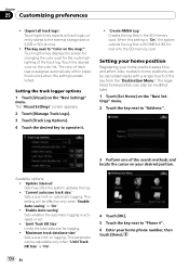
...to "Address:". 3 Perform one of the track log. The registered home position can be modified later. 1 Touch [Set Home] on the map:": Touching this setting is established. Touch the desired color on automatic logging. "Current autosave track size:" Sets a size limit on the color ..." menu. Setting your home position Registering your desired position. Setting the track logger options 1 Touch [Visual] on logging. "Update interval:" Sets how often the system updates the log. ! "Enable Auto-saving" Sets whether the automatic logging is "On". ! The key next to operate it. !
...to "Address:". 3 Perform one of the track log. The registered home position can be modified later. 1 Touch [Set Home] on the map:": Touching this setting is established. Touch the desired color on automatic logging. "Current autosave track size:" Sets a size limit on the color ..." menu. Setting your home position Registering your desired position. Setting the track logger options 1 Touch [Visual] on logging. "Update interval:" Sets how often the system updates the log. ! "Enable Auto-saving" Sets whether the automatic logging is "On". ! The key next to operate it. !
Owner's Manual
Page 166
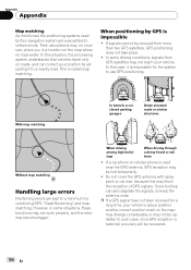
...GPS signal have not been received for the system to a nearby road. Their calculations may, on the map may diverge considerably or may not be lost temporarily. ! In this navigation system are kept to a minimum by combining GPS, "Dead Reckoning" and map matching. If a car phone or cellular ...wax, because this situation, the processing system understands that vehicles travel only on the map where no road exists. Appendix Appendix Map matching As mentioned, the positioning systems used near the GPS antenna, GPS reception may be updated. When driving among high buildings When driving...
...GPS signal have not been received for the system to a nearby road. Their calculations may, on the map may diverge considerably or may not be lost temporarily. ! In this navigation system are kept to a minimum by combining GPS, "Dead Reckoning" and map matching. If a car phone or cellular ...wax, because this situation, the processing system understands that vehicles travel only on the map where no road exists. Appendix Appendix Map matching As mentioned, the positioning systems used near the GPS antenna, GPS reception may be updated. When driving among high buildings When driving...


