
Owners Manual
Page 84
... existing traffic regulations. switch between Map mode/Arrow mode/Split Screen mode • Set FURTHER destination - display a map • CANCEL ROUTE/NEW ROUTE - set an updated route to a halt before using any of the road ahead • Guidance mode - locate (and route to after a certain distance • DETOUR - The Guidance menu...
... existing traffic regulations. switch between Map mode/Arrow mode/Split Screen mode • Set FURTHER destination - display a map • CANCEL ROUTE/NEW ROUTE - set an updated route to a halt before using any of the road ahead • Guidance mode - locate (and route to after a certain distance • DETOUR - The Guidance menu...

Owners Manual
Page 106
... the same as in "Defining an area to be avoided". • All registered areas are avoided when setting a route. The area is deleted and the updated list of areas to be avoided is displayed. • If you can also be displayed.
... the same as in "Defining an area to be avoided". • All registered areas are avoided when setting a route. The area is deleted and the updated list of areas to be avoided is displayed. • If you can also be displayed.

Owners Manual
Page 129
This Mobile Navigation System brings together a number of your vehicle's position. Here, we provide an outline of the technology used in communications, computer technology, and engineering have made it possible to provide you with an accurate, and constantly updated, indication of these techniques to determine a location on earth with remarkable accuracy. Positioning Technology Recent advances in the system.
This Mobile Navigation System brings together a number of your vehicle's position. Here, we provide an outline of the technology used in communications, computer technology, and engineering have made it possible to provide you with an accurate, and constantly updated, indication of these techniques to determine a location on earth with remarkable accuracy. Positioning Technology Recent advances in the system.

Owners Manual
Page 152
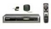
... flat aerial/right-handed helical polarisation Dimensions 51 (W) x 53 (H) x 16 (D) mm Weight 0.13 kg Commander Dimensions 38 (W) x 153 (H) x 33 (D) mm Weight 0.08 kg Usable discs PIONEER Navigation CD-ROMs Maximum current consumption 1.0 A Power source 14.4 V DC (10.8 - 15.1 V allowed) Earthing system Negative earth Dimensions 277 (W) x 52 (H) x 175 (D) mm Weight 1.9 kg &#... System L1, C/A code GPS SPS (Standard Positioning Service) Reception system 8-channel multi-channel reception system Reception frequency 1,575.42 MHz Sensitivity 130 dBm Position update frequency Approx.
... flat aerial/right-handed helical polarisation Dimensions 51 (W) x 53 (H) x 16 (D) mm Weight 0.13 kg Commander Dimensions 38 (W) x 153 (H) x 33 (D) mm Weight 0.08 kg Usable discs PIONEER Navigation CD-ROMs Maximum current consumption 1.0 A Power source 14.4 V DC (10.8 - 15.1 V allowed) Earthing system Negative earth Dimensions 277 (W) x 52 (H) x 175 (D) mm Weight 1.9 kg &#... System L1, C/A code GPS SPS (Standard Positioning Service) Reception system 8-channel multi-channel reception system Reception frequency 1,575.42 MHz Sensitivity 130 dBm Position update frequency Approx.

