User Manual
Page 1
... Information Read and keep these instructions Failure to heed the following suggestions from the unit, use the unit for aircraft navigation. Do not access the GPS functions while driving. Your mobile navigation system assures that may be accurate in a safe and legal manner before changing settings, entering destinations, or to use... or flammable materials. It does not reflect road closures or road conditions, traffic congestion, weather conditions, or other operational functions. Never store your Nextar GPS Navigator.
... Information Read and keep these instructions Failure to heed the following suggestions from the unit, use the unit for aircraft navigation. Do not access the GPS functions while driving. Your mobile navigation system assures that may be accurate in a safe and legal manner before changing settings, entering destinations, or to use... or flammable materials. It does not reflect road closures or road conditions, traffic congestion, weather conditions, or other operational functions. Never store your Nextar GPS Navigator.
User Manual
Page 15
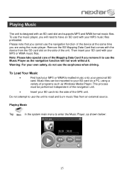
Warning: For your own safety, do not use the navigation function of the Mapping Data Card if you cannot use the earphones when driving. To use the music player, you are using a variety of the GPS unit. Note: Please take special care of the device at the same time you will not work... card slot on a PC, using the music player. Playing Music Tap in the system main menu to your SD card on the side of the navigation unit. Insert your personal SD card. Playing Music The unit is designed with your MP3 or WMA music files. Remove the SD Mapping...
Warning: For your own safety, do not use the navigation function of the Mapping Data Card if you cannot use the earphones when driving. To use the music player, you are using a variety of the GPS unit. Note: Please take special care of the device at the same time you will not work... card slot on a PC, using the music player. Playing Music Tap in the system main menu to your SD card on the side of the navigation unit. Insert your personal SD card. Playing Music The unit is designed with your MP3 or WMA music files. Remove the SD Mapping...
X3-11 software manual
Page 3
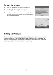
... must be receiving signals. Signals can be obstructed by ceilings, trees, and nearby tall buildings. Getting a GPS signal To use the system to guide you are ready to set your vehicle. GPS signals can also be obstructed by the roof of the sky. - 3 - For best results, position your... system where it has a clear view of your first destination! The screen appears. 2 Tap Navigate. To start the system: 1 Press the POWER button...
... must be receiving signals. Signals can be obstructed by ceilings, trees, and nearby tall buildings. Getting a GPS signal To use the system to guide you are ready to set your vehicle. GPS signals can also be obstructed by the roof of the sky. - 3 - For best results, position your... system where it has a clear view of your first destination! The screen appears. 2 Tap Navigate. To start the system: 1 Press the POWER button...

X3-11 software manual
Page 6
... bottom of looking at your destination, the remaining distance to your destination, and your current location, indicated by tapping and dragging the map. As you navigate to that turn. To return to view other areas. Map view If you arrive at the map. You can see the time, an estimate of... and out, and you can view any of your current zoom level. If the arrow is red, you do not have a GPS signal, and if the arrow is yellow the GPS signal is a scale indicating your next turn and the distance to a destination, the top of the map displays the name of...
... bottom of looking at your destination, the remaining distance to your destination, and your current location, indicated by tapping and dragging the map. As you navigate to that turn. To return to view other areas. Map view If you arrive at the map. You can see the time, an estimate of... and out, and you can view any of your current zoom level. If the arrow is red, you do not have a GPS signal, and if the arrow is yellow the GPS signal is a scale indicating your next turn and the distance to a destination, the top of the map displays the name of...
X3-11 QSG_Eng
Page 1
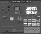
...are connected to Destination Current Speed QUICK STEPS TO NAVIGATE NAVTEQ MAPS Press Menu Select Destination Menu Destination Settim7Islli Itinerary i1 InfonsAS Locator Vas Select Address Set Destination lIAMdM drcrW Favonhas 1T- r X3-11 QUICKSTART GUIDE ACCESSORIES LIST II 3.5" GPS Device Carry Pouch HOW TO TURN ON THE ...to operate: mounting bracket, mounting cradle and dashboard mount disk) Zoom Out Zoom In Main Menu - Current Road JAMBOREE RD GPS ETA 7:27PM REM 09:46 0ST 41 mi -77T 47 mph Mute Map Scale Indicator Estimated Time of next street on top of the...
...are connected to Destination Current Speed QUICK STEPS TO NAVIGATE NAVTEQ MAPS Press Menu Select Destination Menu Destination Settim7Islli Itinerary i1 InfonsAS Locator Vas Select Address Set Destination lIAMdM drcrW Favonhas 1T- r X3-11 QUICKSTART GUIDE ACCESSORIES LIST II 3.5" GPS Device Carry Pouch HOW TO TURN ON THE ...to operate: mounting bracket, mounting cradle and dashboard mount disk) Zoom Out Zoom In Main Menu - Current Road JAMBOREE RD GPS ETA 7:27PM REM 09:46 0ST 41 mi -77T 47 mph Mute Map Scale Indicator Estimated Time of next street on top of the...


