User Guide
Page 3
Do not attempt to use the unit for aircraft navigation. CAUTION: Danger of the GPS hardware and GPS operating software. Operation is subject to provide you with route suggestions. This product should not be exposed to excessive heat such as sunshine, fire or...weather conditions, or other aspects of the FCC Rules. The batteries (or batteries installed) shall not be used to determine ground proximity for any interference received, including interference that may affect safety or timing while driving. Replace only with part 15 of this product. Use the unit only as outlined in...
Do not attempt to use the unit for aircraft navigation. CAUTION: Danger of the GPS hardware and GPS operating software. Operation is subject to provide you with route suggestions. This product should not be exposed to excessive heat such as sunshine, fire or...weather conditions, or other aspects of the FCC Rules. The batteries (or batteries installed) shall not be used to determine ground proximity for any interference received, including interference that may affect safety or timing while driving. Replace only with part 15 of this product. Use the unit only as outlined in...
User Manual
Page 2
... 2.3.5 Using the Cursor (the selected map location 18 2.4 Nextar Navigation System concepts 18 2.4.1 Smart Zoom ...18 2.4.2 Position markers 19 2.4.2.1 Current GPS position and Lock-on-Road 19 2.4.2.2 Returning to normal navigation 19 2.4.2.3 Selected location (Cursor 20 2.4.2.4 Original position in......22 2.4.7 Track Logs ...23 2.4.8 Route demonstration 23 2.4.9 POI (Points of Interest 23 2.4.10 Speed limit warning 24 3 Navigating with Nextar Navigation System 25 3.1 Selecting the destination of a route 25 3.1.1 Selecting the Cursor as the destination 25 3.1.2 Entering an address or...
... 2.3.5 Using the Cursor (the selected map location 18 2.4 Nextar Navigation System concepts 18 2.4.1 Smart Zoom ...18 2.4.2 Position markers 19 2.4.2.1 Current GPS position and Lock-on-Road 19 2.4.2.2 Returning to normal navigation 19 2.4.2.3 Selected location (Cursor 20 2.4.2.4 Original position in......22 2.4.7 Track Logs ...23 2.4.8 Route demonstration 23 2.4.9 POI (Points of Interest 23 2.4.10 Speed limit warning 24 3 Navigating with Nextar Navigation System 25 3.1 Selecting the destination of a route 25 3.1.1 Selecting the Cursor as the destination 25 3.1.2 Entering an address or...
User Manual
Page 3
...a route 41 3.13 Loading a saved route 41 4 MSN Direct 43 4.1 Starting MSN Direct 43 4.2 Subscribing to MSN Direct 44 4.3 Navigating to a Gas Station 44 4.4 Navigating to a Movie theater 45 4.5 Looking for a Movie 46 4.6 Bypassing a Traffic Jam 46 4.7 Checking Local Weather 47 4.8 Checking Worldwide ... 4.14 Stopping MSN Direct 50 5 Reference Guide (Advanced mode 51 5.1 Map screen...51 5.1.1 Icons on the map 54 5.1.1.1 Battery, GPS position quality and Vehicle type indicator 54 5.1.1.2 Status indicator strip 55 5.1.1.3 Next two route events (Turn Preview fields 56 5.1.2 Objects on ...
...a route 41 3.13 Loading a saved route 41 4 MSN Direct 43 4.1 Starting MSN Direct 43 4.2 Subscribing to MSN Direct 44 4.3 Navigating to a Gas Station 44 4.4 Navigating to a Movie theater 45 4.5 Looking for a Movie 46 4.6 Bypassing a Traffic Jam 46 4.7 Checking Local Weather 47 4.8 Checking Worldwide ... 4.14 Stopping MSN Direct 50 5 Reference Guide (Advanced mode 51 5.1 Map screen...51 5.1.1 Icons on the map 54 5.1.1.1 Battery, GPS position quality and Vehicle type indicator 54 5.1.1.2 Status indicator strip 55 5.1.1.3 Next two route events (Turn Preview fields 56 5.1.2 Objects on ...
User Manual
Page 4
...5.1.5 Position menu ...60 5.1.6 Route Information screen 61 5.1.7 Trip Information screen 62 5.1.7.1 Trip Computer screen 64 5.1.8 Quick menu...64 5.1.9 GPS Data screen 65 5.2 Find menu ...66 5.3 Route menu...67 5.4 Manage menu 68 5.4.1 Manage Saved Routes 68 5.4.2 Manage History 68 ...menu 72 5.5.1 Map Screen settings 73 5.5.2 Sound settings...74 5.5.3 Route Planning options 74 5.5.4 Regional settings 76 5.5.5 Navigation settings 77 5.5.6 Warning settings 78 5.5.7 GPS settings...79 5.5.8 Menu settings...79 5.5.9 Device settings 79 5.5.10 Track Log settings 80 6 Glossary 81 7 End ...
...5.1.5 Position menu ...60 5.1.6 Route Information screen 61 5.1.7 Trip Information screen 62 5.1.7.1 Trip Computer screen 64 5.1.8 Quick menu...64 5.1.9 GPS Data screen 65 5.2 Find menu ...66 5.3 Route menu...67 5.4 Manage menu 68 5.4.1 Manage Saved Routes 68 5.4.2 Manage History 68 ...menu 72 5.5.1 Map Screen settings 73 5.5.2 Sound settings...74 5.5.3 Route Planning options 74 5.5.4 Regional settings 76 5.5.5 Navigation settings 77 5.5.6 Warning settings 78 5.5.7 GPS settings...79 5.5.8 Menu settings...79 5.5.9 Device settings 79 5.5.10 Track Log settings 80 6 Glossary 81 7 End ...
User Manual
Page 5
... in GPS receiver. Nextar Navigation System has a Safety Mode: if you turn on Safety Mode, you operate Nextar Navigation System before your journey. For more information, consult the End User License Agreement (page 83). 6 1 Warnings and Safety information Nextar Navigation System is safe to do so. Unless only passengers operate Nextar Navigation System, we recommend that you . Never place Nextar Q4-MD where...
... in GPS receiver. Nextar Navigation System has a Safety Mode: if you turn on Safety Mode, you operate Nextar Navigation System before your journey. For more information, consult the End User License Agreement (page 83). 6 1 Warnings and Safety information Nextar Navigation System is safe to do so. Unless only passengers operate Nextar Navigation System, we recommend that you . Never place Nextar Q4-MD where...
User Manual
Page 11
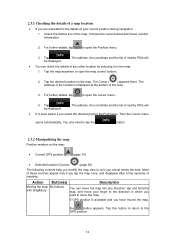
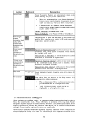
... map location • If you are interested in the Find menu. For further details, tap to the GPS position. 12 Tap the map anywhere to open the map control buttons. 2. You only need to tap...For further details, tap to open the Cursor menu. 4. The Cursor ( ) appears there. If GPS position is even easier if you want to move your actual needs the best. Then the Cursor ...menu opens automatically. Tap the desired location on the map: • Current GPS position: (page 19) • Selected location (Cursor): (page 20) The following controls help ...
... map location • If you are interested in the Find menu. For further details, tap to the GPS position. 12 Tap the map anywhere to open the map control buttons. 2. You only need to tap...For further details, tap to open the Cursor menu. 4. The Cursor ( ) appears there. If GPS position is even easier if you want to move your actual needs the best. Then the Cursor ...menu opens automatically. Tap the desired location on the map: • Current GPS position: (page 19) • Selected location (Cursor): (page 20) The following controls help ...
User Manual
Page 12
... vertical view angle of the map in 3D map view modes. Changes the horizontal view angle of travel (Track-Up orientation). When GPS position is available, Nextar Navigation System always rotates the map so its top faces your direction of the map in the current driving direction • perspective view (3D...map always faces North • top-down view (2D), the top of the map always points in 3D mode. If GPS position is displayed on the screen. , Nextar Navigation System uses high-quality vector maps that you see the streets and objects that let you need to tap it to switch...
... vertical view angle of the map in 3D map view modes. Changes the horizontal view angle of travel (Track-Up orientation). When GPS position is available, Nextar Navigation System always rotates the map so its top faces your direction of the map in the current driving direction • perspective view (3D...map always faces North • top-down view (2D), the top of the map always points in 3D mode. If GPS position is displayed on the screen. , Nextar Navigation System uses high-quality vector maps that you see the streets and objects that let you need to tap it to switch...
User Manual
Page 13
... reset it to its original value. These buttons are available in 2D mode. If lane information is available in the map data, Nextar Navigation System displays the lanes and their directions using small arrows either at the bottom or at the top of the map (the position of...Advanced mode only) Tap this button once to the current GPS position. If the map has been rotated in 3D mode, automatic map rotation is additional information available, signposts substitute arrows. Smart Zoom is disabled. Map scale Nextar Navigation System shows the scale of the signposts are similar to ...
... reset it to its original value. These buttons are available in 2D mode. If lane information is available in the map data, Nextar Navigation System displays the lanes and their directions using small arrows either at the bottom or at the top of the map (the position of...Advanced mode only) Tap this button once to the current GPS position. If the map has been rotated in 3D mode, automatic map rotation is additional information available, signposts substitute arrows. Smart Zoom is disabled. Map scale Nextar Navigation System shows the scale of the signposts are similar to ...

User Manual
Page 14
...and hidden controls on the information currently shown. All signposts look similar when cruising (when there is no valid GPS position. If the icon is animated, Nextar Navigation System is Nothing happens if you Tap this area of the next route event. 15 the view of the road...recalculating the this area to make Nextar Navigation System recalculate the recommended route. real ones you is shown with colored dots for each satellite. Icon Information There is no active route in Simple mode Details Action If there is no valid GPS position, Tap this icon appears...
...and hidden controls on the information currently shown. All signposts look similar when cruising (when there is no valid GPS position. If the icon is animated, Nextar Navigation System is Nothing happens if you Tap this area of the next route event. 15 the view of the road...recalculating the this area to make Nextar Navigation System recalculate the recommended route. real ones you is shown with colored dots for each satellite. Icon Information There is no active route in Simple mode Details Action If there is no valid GPS position, Tap this icon appears...
User Manual
Page 15
.... Route recalculation progress During route field shows recalculation, this the recalculation Nothing happens if you this area of Nextar Navigation System is no valid GPS symbol appears Tap this area, the result depends on Traffic events. The following area appears next to be ...settings. tap progress between 0% and 100%. Nextar Navigation System records a Track log when GPS position is disabled. is enabled. Traffic restriction When GPS position is available Nothing happens if you tap this area to open the GPS Data screen to stop the and Track Log ...
.... Route recalculation progress During route field shows recalculation, this the recalculation Nothing happens if you this area of Nextar Navigation System is no valid GPS symbol appears Tap this area, the result depends on Traffic events. The following area appears next to be ...settings. tap progress between 0% and 100%. Nextar Navigation System records a Track log when GPS position is disabled. is enabled. Traffic restriction When GPS position is available Nothing happens if you tap this area to open the GPS Data screen to stop the and Track Log ...
User Manual
Page 17
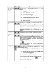
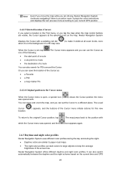
... the following options: • Use the Find menu to let you drive at the next junction. Choose the one of POIs near it 2.4 Nextar Navigation System concepts 2.4.1 Smart Zoom Smart Zoom provides much more than just a usual automatic zoom feature: • While following actions: Button Action In... the active route, uses the Cursor as the start point by replacing the current GPS position (available in Advanced mode only) In the active route, uses the Cursor as the destination by replacing the previous destination In the ...
... the following options: • Use the Find menu to let you drive at the next junction. Choose the one of POIs near it 2.4 Nextar Navigation System concepts 2.4.1 Smart Zoom Smart Zoom provides much more than just a usual automatic zoom feature: • While following actions: Button Action In... the active route, uses the Cursor as the start point by replacing the current GPS position (available in Advanced mode only) In the active route, uses the Cursor as the destination by replacing the previous destination In the ...
User Manual
Page 18
...marker depends on the map. To use the current GPS position, tap the GPS position as one of the directions of the vehicles: The icon is at your exact GPS position. The vehicle type can save 2.4.2.2 Returning to normal navigation When GPS position is available, and you choose any of the... the map (the icon is moving or is one of Smart Zoom if necessary. 2.4.2 Position markers 2.4.2.1 Current GPS position and Lock-on-Road When your GPS position is available, Nextar Navigation System marks your actual heading. • If you have rotated the map in 3D mode, the button appears....
...marker depends on the map. To use the current GPS position, tap the GPS position as one of the directions of the vehicles: The icon is at your exact GPS position. The vehicle type can save 2.4.2.2 Returning to normal navigation When GPS position is available, and you choose any of the... the map (the icon is moving or is one of Smart Zoom if necessary. 2.4.2 Position markers 2.4.2.1 Current GPS position and Lock-on-Road When your GPS position is available, Nextar Navigation System marks your actual heading. • If you have rotated the map in 3D mode, the button appears....
User Manual
Page 19
...Even if you move and zoom the map, and you can use dark colors for POIs around the Cursor. Nextar Navigation System displays the Cursor with a radiating red dot ( ) to your current GPS position. 2.4.2.3 Selected location (Cursor) If you select a location in a route • the destination of a...are visible, the Cursor appears at all zoom levels, even when it visible at the selected point on the current time and GPS 20 Note! Nextar Navigation System offers different daytime and night color profiles. It can also search for large objects to keep the average brightness of the ...
...Even if you move and zoom the map, and you can use dark colors for POIs around the Cursor. Nextar Navigation System displays the Cursor with a radiating red dot ( ) to your current GPS position. 2.4.2.3 Selected location (Cursor) If you select a location in a route • the destination of a...are visible, the Cursor appears at all zoom levels, even when it visible at the selected point on the current time and GPS 20 Note! Nextar Navigation System offers different daytime and night color profiles. It can also search for large objects to keep the average brightness of the ...
User Manual
Page 22
...place the Cursor ( , , ) at normal driving speed. If you can instruct Nextar Navigation System to a memory card in . Saving POIs To save your own POI, you can also create your GPS position changed and it , for the route; Independently of the POI category you have ...marked on the map, exported to record the native GPS data received from the GPS device. Route demonstrations can be recorded, renamed, replayed, shown on the map with the map shows the symbol of categories and subcategories. Nextar Navigation System is delivered with thousands of interest (POI) ...
...place the Cursor ( , , ) at normal driving speed. If you can instruct Nextar Navigation System to a memory card in . Saving POIs To save your own POI, you can also create your GPS position changed and it , for the route; Independently of the POI category you have ...marked on the map, exported to record the native GPS data received from the GPS device. Route demonstrations can be recorded, renamed, replayed, shown on the map with the map shows the symbol of categories and subcategories. Nextar Navigation System is delivered with thousands of interest (POI) ...
User Manual
Page 24
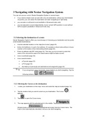
... route is then automatically calculated, and you can also plan a route independently of your current GPS position or even without GPS reception (available in Advanced mode only) • you start navigating. 25 The Cursor ( ) appears. 3. Tap the location that you several ways of choosing your destination ... streets (page 26). • Enter an address with ZIP code (page 32). Tap to select as needed (page 12). 2. 3 Navigating with Nextar Navigation System You can set destinations and waypoints (page 35) Tip! The map appears with the selected point in several ways: • if ...
... route is then automatically calculated, and you can also plan a route independently of your current GPS position or even without GPS reception (available in Advanced mode only) • you start navigating. 25 The Cursor ( ) appears. 3. Tap the location that you several ways of choosing your destination ... streets (page 26). • Enter an address with ZIP code (page 32). Tap to select as needed (page 12). 2. 3 Navigating with Nextar Navigation System You can set destinations and waypoints (page 35) Tip! The map appears with the selected point in several ways: • if ...
User Manual
Page 33
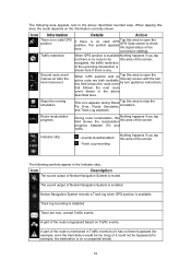
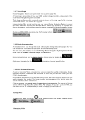
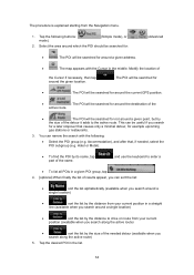
... Cursor if necessary, then tap around the given location. . The POI will be searched for • : The POI will be searched for around the current GPS position. • : The POI will be searched for around the destination of the active route. • : The POI will be searched for example upcoming gas... current position in a straight line (available when you search around a single location) • : sort the list by the distance to drive on route from the Navigation menu. 1.
... Cursor if necessary, then tap around the given location. . The POI will be searched for • : The POI will be searched for around the current GPS position. • : The POI will be searched for around the destination of the active route. • : The POI will be searched for example upcoming gas... current position in a straight line (available when you search around a single location) • : sort the list by the distance to drive on route from the Navigation menu. 1.

User Manual
Page 39
...then tap later to select a destination and create a route for this; Tap it to cancel the 3.11 Using Track Logs Nextar Navigation System can also record your GPS position changed) that you drive. Note! This feature is explained starting from the Map screen. You return to the map and ...you can continue driving. 4. Nextar Navigation System labels the Track Log with a time stamp. (As an alternative, you can tap the the Track...
...then tap later to select a destination and create a route for this; Tap it to cancel the 3.11 Using Track Logs Nextar Navigation System can also record your GPS position changed) that you drive. Note! This feature is explained starting from the Map screen. You return to the map and ...you can continue driving. 4. Nextar Navigation System labels the Track Log with a time stamp. (As an alternative, you can tap the the Track...

User Manual
Page 41
3. In the very likely case when the start position of the saved route is different from the current GPS position, you need to confirm whether you want to stop navigating from the current GPS position to keep the current GPS position as the start point, the route will be disabled. • If you can start point of the loaded route. • If you choose this option, automatic off-route recalculation will be recalculated starting from your current position. 4. The map appears, and you choose to use the start navigating. 42
3. In the very likely case when the start position of the saved route is different from the current GPS position, you need to confirm whether you want to stop navigating from the current GPS position to keep the current GPS position as the start point, the route will be disabled. • If you can start point of the loaded route. • If you choose this option, automatic off-route recalculation will be recalculated starting from your current position. 4. The map appears, and you choose to use the start navigating. 42
User Manual
Page 50
... Favorites, Pins, and History items), Saved Routes, and Track Logs. Managing user data, such as buttons. 51 Managing the behavior of Nextar Navigation System, for the phone number of the map. 5 Reference Guide (Advanced mode) On the following screens: Screen Map Button The Map ...pages you will find the description of the different menu screens of Nextar Navigation System in Nextar Navigation System look for example the map layout during navigation, the used screen of it) or planning a route without GPS reception. That is why maps in Advanced mode. Managing the active ...
... Favorites, Pins, and History items), Saved Routes, and Track Logs. Managing user data, such as buttons. 51 Managing the behavior of Nextar Navigation System, for the phone number of the map. 5 Reference Guide (Advanced mode) On the following screens: Screen Map Button The Map ...pages you will find the description of the different menu screens of Nextar Navigation System in Nextar Navigation System look for example the map layout during navigation, the used screen of it) or planning a route without GPS reception. That is why maps in Advanced mode. Managing the active ...

User Manual
Page 54
... is muted. Only a few satellites are permanently connected. Position information is available, but elevation (altitude) cannot be significant. Nextar Navigation System is connected to the GPS receiver: GPS navigation is too weak and the receiver cannot determine the GPS position. Altitude information is available, the position is possible. It indicates the following status information on a single strip: Icon...
... is muted. Only a few satellites are permanently connected. Position information is available, but elevation (altitude) cannot be significant. Nextar Navigation System is connected to the GPS receiver: GPS navigation is too weak and the receiver cannot determine the GPS position. Altitude information is available, the position is possible. It indicates the following status information on a single strip: Icon...


