
Instruction Manual
Page 9
... hard drive space -Available serial port and/or USB Port -256-color display adapter and monitor (16 bit color required) In the near future map updates will be available for down load from the power supply before you to connect the unit to PC for the information on downloads. 8 Please... check www.nextar.com periodically for map updating. Connecting to PC The unit is designed with a USB port which allows you attempt to connect the unit to any other external...
... hard drive space -Available serial port and/or USB Port -256-color display adapter and monitor (16 bit color required) In the near future map updates will be available for down load from the power supply before you to connect the unit to PC for the information on downloads. 8 Please... check www.nextar.com periodically for map updating. Connecting to PC The unit is designed with a USB port which allows you attempt to connect the unit to any other external...

Instruction Manual
Page 17
... menu, tap the MENU button to play list menu, as shown below: 16 Turn on the unit. Playing Music The unit is used to store map data, any attempt to open the Flash storage may result in the Flash storage, for the flash storage is designed with SD card slot. It... supports MP3, WMA format files playback. Note: Do not store MP3 and WMA format files in the map data missing and lost. You can insert the SD card with MP3 and WMA format files. 2.
... menu, tap the MENU button to play list menu, as shown below: 16 Turn on the unit. Playing Music The unit is used to store map data, any attempt to open the Flash storage may result in the Flash storage, for the flash storage is designed with SD card slot. It... supports MP3, WMA format files playback. Note: Do not store MP3 and WMA format files in the map data missing and lost. You can insert the SD card with MP3 and WMA format files. 2.

Instruction Manual
Page 19
... open it, the pictures stored in the memory card will be listed on the screen. 18 Photo Viewer The unit is used to store map data, any attempt to open the Flash storage may result in the map data missing and lost. You can insert the SD card with SD card slot.
... open it, the pictures stored in the memory card will be listed on the screen. 18 Photo Viewer The unit is used to store map data, any attempt to open the Flash storage may result in the map data missing and lost. You can insert the SD card with SD card slot.
Instruction Manual
Page 28
... practices. Please make sure that you have no other means to look at the screen. Nextar cannot accept any responsibility whatsoever for emergency response, and the system's maps may not be prudent to observe these precautions and the operating instructions in an unsafe situation,...Your personal judgment, traffic regulations, and common sense must always take precedence over instructions produced by the software instructs you in the Nextar Software Manual. Use your knowledge of looking at the screen for your driving technique, driving knowledge or especially your eyes on ...
... practices. Please make sure that you have no other means to look at the screen. Nextar cannot accept any responsibility whatsoever for emergency response, and the system's maps may not be prudent to observe these precautions and the operating instructions in an unsafe situation,...Your personal judgment, traffic regulations, and common sense must always take precedence over instructions produced by the software instructs you in the Nextar Software Manual. Use your knowledge of looking at the screen for your driving technique, driving knowledge or especially your eyes on ...
Instruction Manual
Page 29
Renewing your destination. If you on the map. If so, the system might not contain accurate information regarding all times. • The database utilized by this situation will correct itself automatically. Because of ...
Renewing your destination. If you on the map. If so, the system might not contain accurate information regarding all times. • The database utilized by this situation will correct itself automatically. Because of ...

Instruction Manual
Page 31
...Using Crossroads 33 Setting a Destination Using an Entry in the Favorites List 36 4 GPS Basics 11 Main Screen Components 12 Changing Map Display Modes 13 Browsing the Map Display 15 Selecting Options and Entering Data 16 Setting Destinations 18 Selecting and Working with Turn-By-Turn Views 19 Main Turn-by...-Turn View 20 Split Map View 20 Maneuvers List View 21 Zooming In and Out 21 Canceling a Route 22 Automatic Route Recalculation 22 Setting and Using Your Home ...
...Using Crossroads 33 Setting a Destination Using an Entry in the Favorites List 36 4 GPS Basics 11 Main Screen Components 12 Changing Map Display Modes 13 Browsing the Map Display 15 Selecting Options and Entering Data 16 Setting Destinations 18 Selecting and Working with Turn-By-Turn Views 19 Main Turn-by...-Turn View 20 Split Map View 20 Maneuvers List View 21 Zooming In and Out 21 Canceling a Route 22 Automatic Route Recalculation 22 Setting and Using Your Home ...

Instruction Manual
Page 32
Setting a Destination Using an Item in the History List 37 Chapter 5 - Other Options 38 Configuring Map Display Settings 38 Selecting a Language 40 Viewing GPS Status 41 Setting Default Route Calculation Criteria 42 Setting Origin 43 Previewing a Route Using Demo Mode 44 Viewing Program Version Information 45 Exiting the Application 46 Chapter 6- Technical Reference 47 Menu Commands 47 Screen Icons and Controls 48 Compass and GPS 48 User Interface Controls and Icons 49 General Turn-By-Turn Symbols 52 FAQ'S...53 Copyright 54 5
Setting a Destination Using an Item in the History List 37 Chapter 5 - Other Options 38 Configuring Map Display Settings 38 Selecting a Language 40 Viewing GPS Status 41 Setting Default Route Calculation Criteria 42 Setting Origin 43 Previewing a Route Using Demo Mode 44 Viewing Program Version Information 45 Exiting the Application 46 Chapter 6- Technical Reference 47 Menu Commands 47 Screen Icons and Controls 48 Compass and GPS 48 User Interface Controls and Icons 49 General Turn-By-Turn Symbols 52 FAQ'S...53 Copyright 54 5

Instruction Manual
Page 33
... routes, and retrieving recently used destinations. Nextar GPS uses a patented and patent pending interface that you leave your route, Nextar GPS automatically calculates a new route to your route is tracked and displayed in compass • Discernible map zoom levels • Multi-modal voice ... and intuitive user interface • Ready for mobile computing platforms. Developed by Nextar, Inc., you get up and running quickly, this manual provides detailed descriptions and instructions on the map display. To help you can install GPS portable computing devices that improves efficiency...
... routes, and retrieving recently used destinations. Nextar GPS uses a patented and patent pending interface that you leave your route, Nextar GPS automatically calculates a new route to your route is tracked and displayed in compass • Discernible map zoom levels • Multi-modal voice ... and intuitive user interface • Ready for mobile computing platforms. Developed by Nextar, Inc., you get up and running quickly, this manual provides detailed descriptions and instructions on the map display. To help you can install GPS portable computing devices that improves efficiency...

Instruction Manual
Page 38
... you to key features and common functions in the GPS, this chapter covers- • Starting the GPS • Main Screen Components • Changing Map Display Modes • Browsing the Map Display • Selecting Options and Entering Data • Setting Destinations • Selecting and Working Turn-By-Turn Views • Zooming In and...
... you to key features and common functions in the GPS, this chapter covers- • Starting the GPS • Main Screen Components • Changing Map Display Modes • Browsing the Map Display • Selecting Options and Entering Data • Setting Destinations • Selecting and Working Turn-By-Turn Views • Zooming In and...

Instruction Manual
Page 39
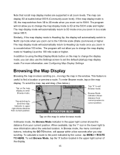
.... (See below .) Tap to toggle between viewing the name of the street or roadway you through the various map display modes-3D, North Up, and Heading Up. (For more information, see Changing Map Display Modes on page 13.) Tapping on , or the name of the next cross street. (See the example... below .) Map Display Mode Button Compass and GPS Status Current Position Icon Point of Interest Icons Map Zoom Level Buttons (+) and (-) Tap icon to the destination setting screens. Along the bottom of the display, the...
.... (See below .) Tap to toggle between viewing the name of the street or roadway you through the various map display modes-3D, North Up, and Heading Up. (For more information, see Changing Map Display Modes on page 13.) Tapping on , or the name of the next cross street. (See the example... below .) Map Display Mode Button Compass and GPS Status Current Position Icon Point of Interest Icons Map Zoom Level Buttons (+) and (-) Tap icon to the destination setting screens. Along the bottom of the display, the...

Instruction Manual
Page 40
...voice guidance on or off. Heading Up, North Up, and 3D. (See below , map icons display Points of Interest along with Turn-ByTurn Views on page 19. Once you to change the map display mode, zoom in blue, along the way. Estimated arrival time and distance to ...alternate views of next maneuver Current Vehicle Position Indicator Current Street / Upcoming Crossroad (Toggle) The Map Display Volume Control for the audible turn-by -turn instructions Next maneuver and distance from that maneuver. For more information, see Selecting and ...
...voice guidance on or off. Heading Up, North Up, and 3D. (See below , map icons display Points of Interest along with Turn-ByTurn Views on page 19. Once you to change the map display mode, zoom in blue, along the way. Estimated arrival time and distance to ...alternate views of next maneuver Current Vehicle Position Indicator Current Street / Upcoming Crossroad (Toggle) The Map Display Volume Control for the audible turn-by -turn instructions Next maneuver and distance from that maneuver. For more information, see Selecting and ...

Instruction Manual
Page 41
The vehicle icon faces in the direction of travel . (See below.) Map Display Mode - North Up In 3D mode, the map displays a 3D perspective of the display. In Heading Up mode, the vehicle icon faces up, i.e., forward in the direction of travel while the compass displays the direction of travel , and the map display rotates under it as the system tracks your route. (See below.) Map Display Mode - Heading Up In North Up mode, the map scrolls so that North on the map is oriented to the top of the road network. (See below.) Map Display Mode - 3D 14
The vehicle icon faces in the direction of travel . (See below.) Map Display Mode - North Up In 3D mode, the map displays a 3D perspective of the display. In Heading Up mode, the vehicle icon faces up, i.e., forward in the direction of travel while the compass displays the direction of travel , and the map display rotates under it as the system tracks your route. (See below.) Map Display Mode - Heading Up In North Up mode, the map scrolls so that North on the map is oriented to the top of the road network. (See below.) Map Display Mode - 3D 14
Instruction Manual
Page 42
.... 15 Browse Mode indicator shows distance from your current position. To calculate a route to find a location or preview a route. This feature is 3D, the map switches from current position. Indicator in the lower right to 3D at the 500 ft scale and higher. When available, tap the "i" icon in upper... to the point indicated by the cursor, tap MENU > ROUTE TO HERE. The program will appear within a few seconds after you to change the map display mode to Heading Up at scales below 500 ft. Note that not all zoom levels. In Browse mode, the menu command buttons, including the...
.... 15 Browse Mode indicator shows distance from your current position. To calculate a route to find a location or preview a route. This feature is 3D, the map switches from current position. Indicator in the lower right to 3D at the 500 ft scale and higher. When available, tap the "i" icon in upper... to the point indicated by the cursor, tap MENU > ROUTE TO HERE. The program will appear within a few seconds after you to change the map display mode to Heading Up at scales below 500 ft. Note that not all zoom levels. In Browse mode, the menu command buttons, including the...
Instruction Manual
Page 43
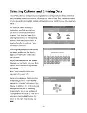
... selections, the screen displays and highlights the most likely options based on the data entry screen. To expand the "mini-list" to the main map display, tap MAP. 16 Items in the database that match the characters you have entered so far appear in the upper left. This predictive method of the...
... selections, the screen displays and highlights the most likely options based on the data entry screen. To expand the "mini-list" to the main map display, tap MAP. 16 Items in the database that match the characters you have entered so far appear in the upper left. This predictive method of the...

Instruction Manual
Page 44
..., the program lists possible matches for you enter city names. To return to match your entry appear in the database that begin to the main map display, tap...
..., the program lists possible matches for you enter city names. To return to match your entry appear in the database that begin to the main map display, tap...
Instruction Manual
Page 45
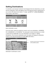
Destination Confirmation screen 18 The subsequent screens will display the destination location on the map and prompt you to select GO. (See below .) Enter Destination screen From this screen, select the method you want to use to enter or select ...
Destination Confirmation screen 18 The subsequent screens will display the destination location on the map and prompt you to select GO. (See below .) Enter Destination screen From this screen, select the method you want to use to enter or select ...

Instruction Manual
Page 46
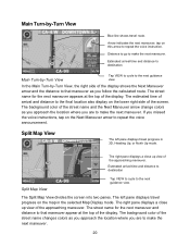
... Tapping on the VIEW button cycles you through three different guidance view displays as follows: • The Main Turn-by-Turn View • The Split Map View • The Maneuvers List View 19
... Tapping on the VIEW button cycles you through three different guidance view displays as follows: • The Main Turn-by-Turn View • The Split Map View • The Maneuvers List View 19
Instruction Manual
Page 47
...change colors as you approach the location where you are to the next guidance view. The Split Map View divides the screen into two panes. The left pane displays travel route. Estimated arrival time and...maneuver as you approach the location where you are to the final location also display on the map in 3D, Heading Up, or North Up mode. The street name for the next maneuver and ...distance to make the next maneuver. 20 Split Map View The left pane displays travel progress on the lower right side of the display. The background...
...change colors as you approach the location where you are to the next guidance view. The Split Map View divides the screen into two panes. The left pane displays travel route. Estimated arrival time and...maneuver as you approach the location where you are to the final location also display on the map in 3D, Heading Up, or North Up mode. The street name for the next maneuver and ...distance to make the next maneuver. 20 Split Map View The left pane displays travel progress on the lower right side of the display. The background...
Instruction Manual
Page 48
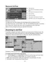
... get a sense of various zoom levels To change zoom levels for calculated route. Use the FIRST, LAST, UP, and DOWN arrow button to set the map zoom level. Tap VIEW to cycle to first maneuver in all the way to country level. (See the examples below.) Examples of where you are... . 21 List of the Next Maneuver arrow changes color as appropriate, e.g., County or City, etc. Tap to jump to the next guidance view. Not all map display modes are supported in the list. Maneuvers List View Next maneuver. Note. Each zoom level is labeled as you to scroll down. Tap to...
... get a sense of various zoom levels To change zoom levels for calculated route. Use the FIRST, LAST, UP, and DOWN arrow button to set the map zoom level. Tap VIEW to cycle to first maneuver in all the way to country level. (See the examples below.) Examples of where you are... . 21 List of the Next Maneuver arrow changes color as appropriate, e.g., County or City, etc. Tap to jump to the next guidance view. Not all map display modes are supported in the list. Maneuvers List View Next maneuver. Note. Each zoom level is labeled as you to scroll down. Tap to...
Instruction Manual
Page 49
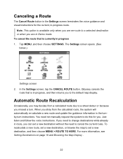
...that is currently in the turnby-turn . Tap MENU, and then choose SETTINGS. You need to the default map display. For more information, see Setting Destinations on page 18 and Browsing the Map Display . 22 If you need to change destinations while already in -progress, and then returns you can set... a new destination without the need not manually request the system to set a new destination, or browse the map to do this for the current, in Demo mode. In the Settings screen, tap the CANCEL ROUTE button. Odyssey cancels the route that is in...
...that is currently in the turnby-turn . Tap MENU, and then choose SETTINGS. You need to the default map display. For more information, see Setting Destinations on page 18 and Browsing the Map Display . 22 If you need to change destinations while already in -progress, and then returns you can set... a new destination without the need not manually request the system to set a new destination, or browse the map to do this for the current, in Demo mode. In the Settings screen, tap the CANCEL ROUTE button. Odyssey cancels the route that is in...


