
Owners Manual
Page 2
... 18-25 Installation sequence for the suction-cup mount . . . . .18-19 Detaching the suction-cup mount 20 Installing the external GPS antenna (Optional 20-21 Installing Microsoft ActiveSync 22 Connecting the USB cable 22-23 Downloading files: ActiveSync 23 Data exchange via card reader 24... Downloading files: Removable disk 24 Disconnecting the USB device 25 Before operation 26-27 Starting up 26 Navigation features 27 Getting started with navigation 28-35 Navigation Menu 28 Address Screen 28 Recent Places Screen 28 My Places Screen 28 POI Screen 29 Route Manager Screen...
... 18-25 Installation sequence for the suction-cup mount . . . . .18-19 Detaching the suction-cup mount 20 Installing the external GPS antenna (Optional 20-21 Installing Microsoft ActiveSync 22 Connecting the USB cable 22-23 Downloading files: ActiveSync 23 Data exchange via card reader 24... Downloading files: Removable disk 24 Disconnecting the USB device 25 Before operation 26-27 Starting up 26 Navigation features 27 Getting started with navigation 28-35 Navigation Menu 28 Address Screen 28 Recent Places Screen 28 My Places Screen 28 POI Screen 29 Route Manager Screen...
Owners Manual
Page 3
Table of contents Finding a location with navigation 36-49 Address Screen 36-37 Go to your Destination 37 Add to My Places 38 Recent Places 38 My Places 39 Favorite Groups 40 ... Setting Stops Along the Route 48 Route Options 49 Setup 50-56 Display 50 Map Views 51 Units & Time 52 Language 52 Guidance 52-23 GPS Status 53 GPS Not Found 54 Map Setup 54-55 Tutorial 55 Help 55 Start Demo 55 Select Map 56 Initialize 56 3
Table of contents Finding a location with navigation 36-49 Address Screen 36-37 Go to your Destination 37 Add to My Places 38 Recent Places 38 My Places 39 Favorite Groups 40 ... Setting Stops Along the Route 48 Route Options 49 Setup 50-56 Display 50 Map Views 51 Units & Time 52 Language 52 Guidance 52-23 GPS Status 53 GPS Not Found 54 Map Setup 54-55 Tutorial 55 Help 55 Start Demo 55 Select Map 56 Initialize 56 3
Owners Manual
Page 17
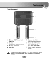
Rear / Side panel Part names 1 2 3 4 6 5 1. Speaker Gives a voice guidance service. 3. USB port 7 5. OFF: Slide switch down. 7. Power supply connector DC 5V Deleting or altering the map data in the built-in memory or the SD memory card randomly, may cause problems in the navigation function. 17 Docking connector 4. Power ON / OFF button ON: Slide switch up. External GPS Antenna Port (Optional) 2. Memory Card Slot Insert a SD Memory Card. 6.
Rear / Side panel Part names 1 2 3 4 6 5 1. Speaker Gives a voice guidance service. 3. USB port 7 5. OFF: Slide switch down. 7. Power supply connector DC 5V Deleting or altering the map data in the built-in memory or the SD memory card randomly, may cause problems in the navigation function. 17 Docking connector 4. Power ON / OFF button ON: Slide switch up. External GPS Antenna Port (Optional) 2. Memory Card Slot Insert a SD Memory Card. 6.
Owners Manual
Page 26
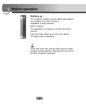
Push the Power button up The navigation software and the digital map material are stored in the built-in memory. The Map screen is fairly automatic. Built-in memory: The application and maps are supplied in the built-in memory. Installation is displayed It may take some time until the GPS receiver initially acquires enough satellites' data during the first use of the GPS navigation equipment. 26 Before operation Starting up to turn on the device.
Push the Power button up The navigation software and the digital map material are stored in the built-in memory. The Map screen is fairly automatic. Built-in memory: The application and maps are supplied in the built-in memory. Installation is displayed It may take some time until the GPS receiver initially acquires enough satellites' data during the first use of the GPS navigation equipment. 26 Before operation Starting up to turn on the device.
Owners Manual
Page 31
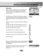
... the "Zoom Out" button, the map displays more of the map view. Last known location when GPS signal is the street that you will turn maneuver. 31 When you tap the "Map" button on the Navigation menu screens, the Main Map screen appears. You can use the icons displayed on with... navigation Main Map When you have calculated a route, the Directions bar displays the direction arrow and the distance...
... the "Zoom Out" button, the map displays more of the map view. Last known location when GPS signal is the street that you will turn maneuver. 31 When you tap the "Map" button on the Navigation menu screens, the Main Map screen appears. You can use the icons displayed on with... navigation Main Map When you have calculated a route, the Directions bar displays the direction arrow and the distance...
Owners Manual
Page 32
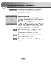
Point on the Map You can navigate to return you later. When you save a point on the map as a favorite destination. This is helpful if you see a location that displays the remaining ... map view. This button lets you tap on a point of arrival. This button lets you the main map. Getting started with navigation The GPS bar is a toggle button that you want to navigate to a specific point on the map, but you don't have the street address. This button lets you cancel the map...
Point on the Map You can navigate to return you later. When you save a point on the map as a favorite destination. This is helpful if you see a location that displays the remaining ... map view. This button lets you tap on a point of arrival. This button lets you the main map. Getting started with navigation The GPS bar is a toggle button that you want to navigate to a specific point on the map, but you don't have the street address. This button lets you cancel the map...
Owners Manual
Page 53
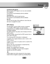
... take a few minutes to ... Altitude: The height above sea level. GPS Status The Navigator uses the GPS receiver to navigate the route. For best results, ensure that the GPS receiver has a clear view of the earth's surface. Number of Satellites: You can set the type of the guidance name that you will use to pinpoint ...
... take a few minutes to ... Altitude: The height above sea level. GPS Status The Navigator uses the GPS receiver to navigate the route. For best results, ensure that the GPS receiver has a clear view of the earth's surface. Number of Satellites: You can set the type of the guidance name that you will use to pinpoint ...

Owners Manual
Page 54
... of street names to make the map easier to the cigarette lighter. The Navigator cannot calculate the route if there is no GPS reception (for uninterrupted GPS reception. The "GPS not found" message means that : • The GPS antenna has a clear view of the sky for example, in at slower ... your map display. Map Setup You can tap the "Map Setup" button to customize your navigation device hasn't yet located a reliable GPS signal. Setup GPS Not Found When you first start the Navigator you manually change the zoom, the Automatic Zoom returns to the cigarette lighter and has a clear...
... of street names to make the map easier to the cigarette lighter. The Navigator cannot calculate the route if there is no GPS reception (for uninterrupted GPS reception. The "GPS not found" message means that : • The GPS antenna has a clear view of the sky for example, in at slower ... your map display. Map Setup You can tap the "Map Setup" button to customize your navigation device hasn't yet located a reliable GPS signal. Setup GPS Not Found When you first start the Navigator you manually change the zoom, the Automatic Zoom returns to the cigarette lighter and has a clear...
Owners Manual
Page 60
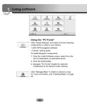
Navigator "PC Portal" installs the selected components to your device: • LGE: GPS navigation software • Tutorial: Tutorial guide To install Navigator components: 1. Using software Using the "PC Portal" Click "Install Software" and select from the list of components, as described above. 2. For more information, see "Installing Maps" on page 63. 60 Click "Manage Maps" to install or remove a map. Click the Install button. 3. From the Install Software screen, select from the following components to install to the device's main memory.
Navigator "PC Portal" installs the selected components to your device: • LGE: GPS navigation software • Tutorial: Tutorial guide To install Navigator components: 1. Using software Using the "PC Portal" Click "Install Software" and select from the list of components, as described above. 2. For more information, see "Installing Maps" on page 63. 60 Click "Manage Maps" to install or remove a map. Click the Install button. 3. From the Install Software screen, select from the following components to install to the device's main memory.

Owners Manual
Page 72
... receiving) GPS cannot be used indoors and must be the same programs (Contained in LGE folder) and maps (Contained in LGE folder) in the SD memory card (Built-in the LGE folder! (It contains important data for navigation. When initially connecting the GPS, it usually takes about 10 minutes ...to a vehicle in a location where the sky can be seen well. • If there are high buildings or if you want to a location where there aren't any obstacles. • Check the GPS receiving condition from the GPS ...
... receiving) GPS cannot be used indoors and must be the same programs (Contained in LGE folder) and maps (Contained in LGE folder) in the SD memory card (Built-in the LGE folder! (It contains important data for navigation. When initially connecting the GPS, it usually takes about 10 minutes ...to a vehicle in a location where the sky can be seen well. • If there are high buildings or if you want to a location where there aren't any obstacles. • Check the GPS receiving condition from the GPS ...

Owners Manual
Page 73
... the map data. Even though GPS is too low, adjust the volume on how to update the data. But for details on the right unit. If the volume is usually very accurate, it has an error range. Cannot see the map even when you have executed the navigation menu. If the problem... and dangerous area information are too close within 10 km. • When you have set the starting , passing and arriving locations are not updated. When GPS receiver is when you select "Guidance" in the product.
... the map data. Even though GPS is too low, adjust the volume on how to update the data. But for details on the right unit. If the volume is usually very accurate, it has an error range. Cannot see the map even when you have executed the navigation menu. If the problem... and dangerous area information are too close within 10 km. • When you have set the starting , passing and arriving locations are not updated. When GPS receiver is when you select "Guidance" in the product.
Owners Manual
Page 74
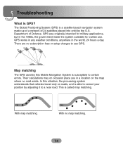
...correct your position by the U.S. GPS GPS GPS GPS Map matching The GPS used by this situation, the processing system understands that vehicles travel only on the map where no road exists. The Global Positioning System (GPS) is a satellite-based navigation system made the system available for ...military applications, but in the world, 24 hours a day. GPS was originally intended for civilian use GPS. In this Mobile Navigation System is able to a near road. This is GPS? Troubleshooting What is called map matching. With no subscription fees or setup ...
...correct your position by the U.S. GPS GPS GPS GPS Map matching The GPS used by this situation, the processing system understands that vehicles travel only on the map where no road exists. The Global Positioning System (GPS) is a satellite-based navigation system made the system available for ...military applications, but in the world, 24 hours a day. GPS was originally intended for civilian use GPS. In this Mobile Navigation System is able to a near road. This is GPS? Troubleshooting What is called map matching. With no subscription fees or setup ...


