Owner's Manual
Page 15
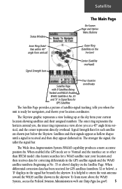
When differential correction data has been received for GPS satellites (numbers 32 or below the Skyview. Signal Strength Bars for each satellite are shown just below ), a 'D' displays in the signal bar beneath the skyview. ... hollow shapes until a signal is helpful to other than RTCM mode), this feature searches for a WAAS satellite near your location and then receives data for correcting differentials in the GPS satellite signals and the WAAS satellite numbers (beginning at No. 33 or above you when the unit is ready for navigation, and...
When differential correction data has been received for GPS satellites (numbers 32 or below the Skyview. Signal Strength Bars for each satellite are shown just below ), a 'D' displays in the signal bar beneath the skyview. ... hollow shapes until a signal is helpful to other than RTCM mode), this feature searches for a WAAS satellite near your location and then receives data for correcting differentials in the GPS satellite signals and the WAAS satellite numbers (beginning at No. 33 or above you when the unit is ready for navigation, and...
Owner's Manual
Page 16
... travel ) or 'North Up' (the satellite skyview oriented to save battery power. You can orient the satellite skyview by the GPS information received. The elevation as determined by selecting 'Track Up' (your location. Select this mode. New Location - If you are more than...etc., but cannot navigate in on the THUMB STICK. 6 Because the eTrex Vista relies on satellite signals to provide you with four options and a brief explanation to gather GPS signals.) The Satellite Page options include: Use With GPS Off - Satellite Options There are four options for faster map drawing)....
... travel ) or 'North Up' (the satellite skyview oriented to save battery power. You can orient the satellite skyview by the GPS information received. The elevation as determined by selecting 'Track Up' (your location. Select this mode. New Location - If you are more than...etc., but cannot navigate in on the THUMB STICK. 6 Because the eTrex Vista relies on satellite signals to provide you with four options and a brief explanation to gather GPS signals.) The Satellite Page options include: Use With GPS Off - Satellite Options There are four options for faster map drawing)....
Owner's Manual
Page 26
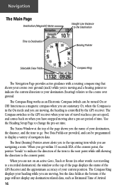
...any destination related data, such as a magnetic compass when you have stopped moving after a pre-set period of time. The Compass switches to the GPS receiver when your destination (bearing) relative to indicate the direction of Arrival. 16 When you are moving, but the data fields at the top of... the page displays the status of the GPS Receiver and the approximate accuracy of your current position. When you are navigating a route. Use the Heading Setup Page to change the pre-set speed,...
...any destination related data, such as a magnetic compass when you have stopped moving after a pre-set period of time. The Compass switches to the GPS receiver when your destination (bearing) relative to indicate the direction of Arrival. 16 When you are moving, but the data fields at the top of... the page displays the status of the GPS Receiver and the approximate accuracy of your current position. When you are navigating a route. Use the Heading Setup Page to change the pre-set speed,...
Owner's Manual
Page 29
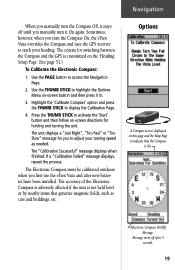
... Menu on this page and the Map Page to adjust your heading. The Electronic Compass must be calibrated outdoors when you first use the eTrex Vista and after 3 seconds. 19 Use the PAGE button to display the Calibration Page. 4. The unit displays a "Just Right", "Too Fast"...On. The "Calibration Successful" message displays when finished. Message turns off until you manually turn the Compass On, the eTrex Vista overrides the Compass and uses the GPS receiver to activate the 'Start' button and then follow on the 'Heading' Setup Page. (See page 51.) To Calibrate the Electronic...
... Menu on this page and the Map Page to adjust your heading. The Electronic Compass must be calibrated outdoors when you first use the eTrex Vista and after 3 seconds. 19 Use the PAGE button to display the Calibration Page. 4. The unit displays a "Just Right", "Too Fast"...On. The "Calibration Successful" message displays when finished. Message turns off until you manually turn the Compass On, the eTrex Vista overrides the Compass and uses the GPS receiver to activate the 'Start' button and then follow on the 'Heading' Setup Page. (See page 51.) To Calibrate the Electronic...
Owner's Manual
Page 62
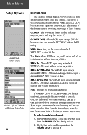
... allows you select 'User' from the Beacon list to manually tune the receiver. Effective use of this feature requires a working knowledge of standard NMEA 0183 version 3.0 data. Provides no interfacing capabilities. Main Menu Setup Options GARMIN Mode with No Options GARMIN Differntial GPS Mode with 'Scan' or you can enter the beacon frequency and...
... allows you select 'User' from the Beacon list to manually tune the receiver. Effective use of this feature requires a working knowledge of standard NMEA 0183 version 3.0 data. Provides no interfacing capabilities. Main Menu Setup Options GARMIN Mode with No Options GARMIN Differntial GPS Mode with 'Scan' or you can enter the beacon frequency and...
Owner's Manual
Page 68
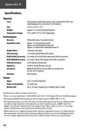
Appendix A Specifications Physical Case: Size: Weight: Temperature Range: Fully-gasketed, high-impact plastic alloy, waterproof to IPX7 standards (waterproof to one meter for 30 minutes) 4.4"H x 2"W x 1.2"D Approx. 5.3 ounces (150 g) w/batteries 5° to 158°F (-15° to 70°C) (operating) Performance Receiver: Differential-ready, 12 parallel channel Acquisition time: Approx. 15 seconds (warm start) Approx. 45 seconds (EZinit/cold start) Approx. 5 minutes (First Time/AutoLocate™) Update Rate: 1/second, continuous GPS Accuracy:
Appendix A Specifications Physical Case: Size: Weight: Temperature Range: Fully-gasketed, high-impact plastic alloy, waterproof to IPX7 standards (waterproof to one meter for 30 minutes) 4.4"H x 2"W x 1.2"D Approx. 5.3 ounces (150 g) w/batteries 5° to 158°F (-15° to 70°C) (operating) Performance Receiver: Differential-ready, 12 parallel channel Acquisition time: Approx. 15 seconds (warm start) Approx. 45 seconds (EZinit/cold start) Approx. 5 minutes (First Time/AutoLocate™) Update Rate: 1/second, continuous GPS Accuracy:
Owner's Manual
Page 74
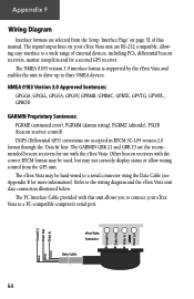
..., GPGSA, GPGSV, GPRMB, GPRMC, GPRTE, GPVTG, GPWPL, GPBOD GARMIN Proprietary Sentences: PGRME (estimated error), PGRMM (datum string), PGRMZ (altitude), PSLIB (beacon receiver control) DGPS (Differential GPS) corrections are accepted in RTCM SC-104 version 2.0 format through the 'Data In' line. Other beacon receivers with this manual. eTrex Vista Connector Data Cable 64 Ground (-) Data Out Data...
..., GPGSA, GPGSV, GPRMB, GPRMC, GPRTE, GPVTG, GPWPL, GPBOD GARMIN Proprietary Sentences: PGRME (estimated error), PGRMM (datum string), PGRMZ (altitude), PSLIB (beacon receiver control) DGPS (Differential GPS) corrections are accepted in RTCM SC-104 version 2.0 format through the 'Data In' line. Other beacon receivers with this manual. eTrex Vista Connector Data Cable 64 Ground (-) Data Out Data...
Owner's Manual
Page 79
... Power Status Window 29 Precautions iii, iv Pressure Plots, View 23 Pressure Sensor Vent 2 Product Registration vii Profile Field 22 Projecting a Waypoint 32 R Receiver Status 5-7, 53 Renaming a Waypoint 30-32 Replacement Battery Cover 59 Reset 24, 27 Restart Search 6 Restore Defaults 11, 17, 27 Route Adding Find Menu item... Setup Map options 15 Setup Menu 49 Setup Page 28, 29 Setup the Navigation Page 18 Set course 16-20 Show Data Fields 11, 13 GPS Elevation 6, 7 Navigation Status 13 Nav Status 11 69
... Power Status Window 29 Precautions iii, iv Pressure Plots, View 23 Pressure Sensor Vent 2 Product Registration vii Profile Field 22 Projecting a Waypoint 32 R Receiver Status 5-7, 53 Renaming a Waypoint 30-32 Replacement Battery Cover 59 Reset 24, 27 Restart Search 6 Restore Defaults 11, 17, 27 Route Adding Find Menu item... Setup Map options 15 Setup Menu 49 Setup Page 28, 29 Setup the Navigation Page 18 Set course 16-20 Show Data Fields 11, 13 GPS Elevation 6, 7 Navigation Status 13 Nav Status 11 69
Owner's Manual
Page 80
Number 53 Use With GPS Off 6, 7 Using Find Menu 54 Goto 40 Main Menu 29 Map 54 Route 41 Track Log 47, 48 V Velocity Made Good 20, 61 Vertical Speed ... Trip Odometer 20, 61 Trip Time Moving 20 Stopped 20 Total 20 Troubleshooting 63 Turn 20, 61 Turning Electronic Compass On and Off ... 18 Turning GPS Receiver "off 6 U Units of Measure 10, 29, 49, 50 Units Page 50 Unit I.D. Index Sight 'N' Go 17 Software License Agreement iv Software Version (operating 29, 53...
Number 53 Use With GPS Off 6, 7 Using Find Menu 54 Goto 40 Main Menu 29 Map 54 Route 41 Track Log 47, 48 V Velocity Made Good 20, 61 Vertical Speed ... Trip Odometer 20, 61 Trip Time Moving 20 Stopped 20 Total 20 Troubleshooting 63 Turn 20, 61 Turning Electronic Compass On and Off ... 18 Turning GPS Receiver "off 6 U Units of Measure 10, 29, 49, 50 Units Page 50 Unit I.D. Index Sight 'N' Go 17 Software License Agreement iv Software Version (operating 29, 53...


