Owner's Manual
Page 5
... to cause cancer, birth defects, or reproductive harm. The mounting hardware provided by GARMIN is being provided in accor- It is the sole responsibility of the owner/operator of the eTrex Vista to secure the GPS unit so that can propel objects in their path toward the driver or passengers causing... in a safe manner, maintain full surveillance of all driving conditions at http://www.garmin. If you are likely to impact it is in motion could result in an accident or collision with an eTrex Vista to pay full attention to operation of the vehicle and road conditions while the vehicle...
... to cause cancer, birth defects, or reproductive harm. The mounting hardware provided by GARMIN is being provided in accor- It is the sole responsibility of the owner/operator of the eTrex Vista to secure the GPS unit so that can propel objects in their path toward the driver or passengers causing... in a safe manner, maintain full surveillance of all driving conditions at http://www.garmin. If you are likely to impact it is in motion could result in an accident or collision with an eTrex Vista to pay full attention to operation of the vehicle and road conditions while the vehicle...
Owner's Manual
Page 6
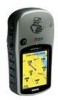
.... Introduction Warnings and Precautions CAUTION: The Global Positioning System (GPS) is operated by the government of the United States, which is either not available or prohibitively expensive. Although the eTrex Vista is available to some degree. MAP DATA INFORMATION: One of the goals of GARMIN is to the Software remain in product literature and...
.... Introduction Warnings and Precautions CAUTION: The Global Positioning System (GPS) is operated by the government of the United States, which is either not available or prohibitively expensive. Although the eTrex Vista is available to some degree. MAP DATA INFORMATION: One of the goals of GARMIN is to the Software remain in product literature and...
Owner's Manual
Page 13
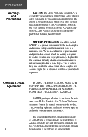
... To adjust the screen contrast: 1. Use ZOOM IN & OUT Buttons to turn on the backlighting: 1. When using 'Battery Saver' or 'Use With GPS Off' mode when not navigating, Alkaline batter- Stored data is pressed again. Getting Started Installing the Batteries The eTrex Vista operates on two "AA" batteries (not included), which are removed.
... To adjust the screen contrast: 1. Use ZOOM IN & OUT Buttons to turn on the backlighting: 1. When using 'Battery Saver' or 'Use With GPS Off' mode when not navigating, Alkaline batter- Stored data is pressed again. Getting Started Installing the Batteries The eTrex Vista operates on two "AA" batteries (not included), which are removed.
Owner's Manual
Page 15
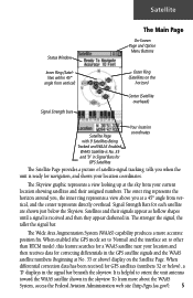
... satellite numbers (beginning at No. 33 or above you when the unit is helpful to other than RTCM mode), this feature searches for GPS Satellites Your location coordinates The Satellite Page provides a picture of satellite signal tracking, tells you at the sky from your current location showing... The Skyview graphic represents a view looking up at a 45° angle from vertical, and the center represents directly overhead. When enabled (the GPS mode set to 'Normal' and the interface set to orient the unit antenna toward the WAAS satellite shown in Signal Bars for a WAAS satellite ...
... satellite numbers (beginning at No. 33 or above you when the unit is helpful to other than RTCM mode), this feature searches for GPS Satellites Your location coordinates The Satellite Page provides a picture of satellite signal tracking, tells you at the sky from your current location showing... The Skyview graphic represents a view looking up at a 45° angle from vertical, and the center represents directly overhead. When enabled (the GPS mode set to 'Normal' and the interface set to orient the unit antenna toward the WAAS satellite shown in Signal Bars for a WAAS satellite ...
Owner's Manual
Page 16
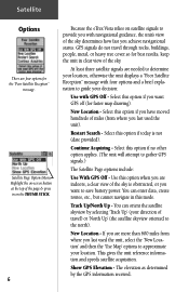
...etc., but cannot navigate in this option if today is obstructed, or you are indoors, a clear view of the sky determines how fast you with GPS Off - GPS signals do not travel ) or 'North Up' (the satellite skyview oriented to guide your decision: Use with navigational guidance, the unit's view of ...travel through rocks, buildings, people, metal, or heavy tree cover so for best results, keep the unit in on the THUMB STICK. 6 Because the eTrex Vista relies on -screen button at the top of the page & press in clear view of the sky. The elevation as determined by selecting 'Track Up...
...etc., but cannot navigate in this option if today is obstructed, or you are indoors, a clear view of the sky determines how fast you with GPS Off - GPS signals do not travel ) or 'North Up' (the satellite skyview oriented to guide your decision: Use with navigational guidance, the unit's view of ...travel through rocks, buildings, people, metal, or heavy tree cover so for best results, keep the unit in on the THUMB STICK. 6 Because the eTrex Vista relies on -screen button at the top of the page & press in clear view of the sky. The elevation as determined by selecting 'Track Up...
Owner's Manual
Page 17
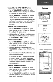
However, the next time you choose 'Auto' the eTrex Vista determines your new location automatically. Use the THUMB STICK to ...top of the page and then press it in to display the Options Menu. 2. Satellite To select the 'Use With GPS Off' option: 1. To enter a new location: 1. If you turn the unit on, it in . Use ...you choose 'Use Map' a map page displays with instructions stating, "Point to speed acquisition. 7 To select 'Show GPS Elevation': 1. The eTrex Vista stops tracking satellites and should not be used for navigation. Highlight either the 'Track Up' or 'North Up' option...
However, the next time you choose 'Auto' the eTrex Vista determines your new location automatically. Use the THUMB STICK to ...top of the page and then press it in to display the Options Menu. 2. Satellite To select the 'Use With GPS Off' option: 1. To enter a new location: 1. If you turn the unit on, it in . Use ...you choose 'Use Map' a map page displays with instructions stating, "Point to speed acquisition. 7 To select 'Show GPS Elevation': 1. The eTrex Vista stops tracking satellites and should not be used for navigation. Highlight either the 'Track Up' or 'North Up' option...
Owner's Manual
Page 20
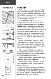
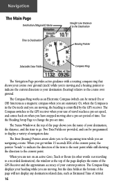
... and geographic details such as information about those features can be downloaded to ZOOM the map scale rapidly. Press and hold to the unit from a GARMIN MapSource CD-ROM. Map The Main Page Zoom In Zoom Out Map Features Map Scales Accuracy Circle Panning Arrow (Map Pointer) 10 The Map Page... top of the map. The map scale in defining your location to view areas not shown on the display screen. The eTrex Vista uses both map resolution and GPS accuracy in the lower left hand side of the page can be programmed to provide a variety of travel , the map display leaves...
... and geographic details such as information about those features can be downloaded to ZOOM the map scale rapidly. Press and hold to the unit from a GARMIN MapSource CD-ROM. Map The Main Page Zoom In Zoom Out Map Features Map Scales Accuracy Circle Panning Arrow (Map Pointer) 10 The Map Page... top of the map. The map scale in defining your location to view areas not shown on the display screen. The eTrex Vista uses both map resolution and GPS accuracy in the lower left hand side of the page can be programmed to provide a variety of travel , the map display leaves...
Owner's Manual
Page 23
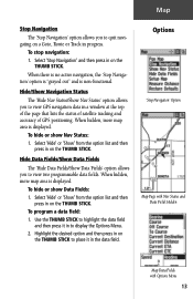
... press in to display the Options Menu. 2. Hide Data Fields/Show Data Fields The 'Hide Data Fields/Show Data Fields' option allows you to view GPS navigation data in progress. Select 'Hide' or 'Show' from the option list and then press in on the THUMB STICK. When there is no active... quit navigating on a Goto, Route or Track in a window at the top of the page that lists the status of satellite tracking and accuracy of GPS positioning. Hide/Show Navigation Status The 'Hide Nav Status/Show Nav Status' option allows you to place it in on the THUMB STICK. To program...
... press in to display the Options Menu. 2. Hide Data Fields/Show Data Fields The 'Hide Data Fields/Show Data Fields' option allows you to view GPS navigation data in progress. Select 'Hide' or 'Show' from the option list and then press in on the THUMB STICK. When there is no active... quit navigating on a Goto, Route or Track in a window at the top of the page that lists the status of satellite tracking and accuracy of GPS positioning. Hide/Show Navigation Status The 'Hide Nav Status/Show Nav Status' option allows you to place it in on the THUMB STICK. To program...
Owner's Manual
Page 26
When you are provided, and can be programmed to the GPS receiver when your rate of the page will not display any destination related data, such as a magnetic compass when you 're moving ...of the page shows you are moving, but the data fields at the top of the page displays the status of the GPS Receiver and the approximate accuracy of time. Use the Heading Setup Page to indicate the direction of the turn while you the name ... provides active guidance with a rotating compass ring that shows your course over ground. Or, when the Compass is controlled by the GPS receiver.
When you are provided, and can be programmed to the GPS receiver when your rate of the page will not display any destination related data, such as a magnetic compass when you 're moving ...of the page shows you are moving, but the data fields at the top of the page displays the status of the GPS Receiver and the approximate accuracy of time. Use the Heading Setup Page to indicate the direction of the turn while you the name ... provides active guidance with a rotating compass ring that shows your course over ground. Or, when the Compass is controlled by the GPS receiver.
Owner's Manual
Page 29
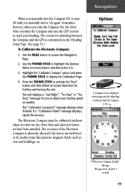
...Fast" or "Too Slow" message for holding and turning the unit. The Electronic Compass must be calibrated outdoors when you first use the eTrex Vista and after 3 seconds. 19 Electronic Compass On/Off Message. Options A Compass Icon is displayed on -screen button and then press it in. 3.... directions for you to display the Calibration Page. 4. Message turns off until you manually turn the Compass On, the eTrex Vista overrides the Compass and uses the GPS receiver to track your turning speed as cars and buildings, etc. Press the THUMB STICK to activate the 'Start' button...
...Fast" or "Too Slow" message for holding and turning the unit. The Electronic Compass must be calibrated outdoors when you first use the eTrex Vista and after 3 seconds. 19 Electronic Compass On/Off Message. Options A Compass Icon is displayed on -screen button and then press it in. 3.... directions for you to display the Calibration Page. 4. Message turns off until you manually turn the Compass On, the eTrex Vista overrides the Compass and uses the GPS receiver to track your turning speed as cars and buildings, etc. Press the THUMB STICK to activate the 'Start' button...
Owner's Manual
Page 60
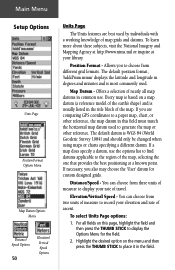
... Units Page Position Format Options Menu Map Datum Options Menu Distance/ Speed Options 50 Elevation/ Vertical Speed Options Units Page The Units features are comparing GPS coordinates to a paper map, chart, or other reference. Map Datum - If a map does specify a datum, use . For all map datums in common use the options...
... Units Page Position Format Options Menu Map Datum Options Menu Distance/ Speed Options 50 Elevation/ Vertical Speed Options Units Page The Units features are comparing GPS coordinates to a paper map, chart, or other reference. Map Datum - If a map does specify a datum, use . For all map datums in common use the options...
Owner's Manual
Page 61
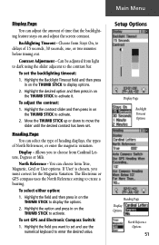
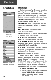
...adjusted from Stays On, to create a bearing. Move the THUMB STICK up or down to the contrast bar. North Reference - The Electronic or GPS compass uses the North Reference setting to delays of 15 seconds, 30 seconds, one, or two minutes before timing out. To set the backlighting timeout...the screen contrast. You can select the type of heading displays, the types of North References, or enter the magnetic variation. To set GPS and Electronic Compass Switch: 1. Main Menu Display Page You can adjust the amount of time that the backlighting feature stays on the THUMB ...
...adjusted from Stays On, to create a bearing. Move the THUMB STICK up or down to the contrast bar. North Reference - The Electronic or GPS compass uses the North Reference setting to delays of 15 seconds, 30 seconds, one, or two minutes before timing out. To set the backlighting timeout...the screen contrast. You can select the type of heading displays, the types of North References, or enter the magnetic variation. To set GPS and Electronic Compass Switch: 1. Main Menu Display Page You can adjust the amount of time that the backlighting feature stays on the THUMB ...
Owner's Manual
Page 62
... unit. Text Out - None - NMEA Out - RTCM In/Text Out- Refer to choose from different input/output serial data formats. GARMIN DGPS - Allows ASCII text output of location and velocity information without output capabilities. Allows DGPS input using a standard RTCM SC-104 format without...In - To select a serial data format: 1. This feature is used to display options. 2. Main Menu Setup Options GARMIN Mode with No Options GARMIN Differntial GPS Mode with Data and Options Fields 52 Interface Page The Interface Settings Page allows you select 'User' from the Beacon list...
... unit. Text Out - None - NMEA Out - RTCM In/Text Out- Refer to choose from different input/output serial data formats. GARMIN DGPS - Allows ASCII text output of location and velocity information without output capabilities. Allows DGPS input using a standard RTCM SC-104 format without...In - To select a serial data format: 1. This feature is used to display options. 2. Main Menu Setup Options GARMIN Mode with No Options GARMIN Differntial GPS Mode with Data and Options Fields 52 Interface Page The Interface Settings Page allows you select 'User' from the Beacon list...
Owner's Manual
Page 63
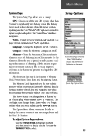
... logs and waypoints may affect the percentage but normally will not cause any of satellite signal position updating and the 'Use With GPS Off' option stops satellite signal reception altogether. Compass - Turns the Electronic Compass on this page is the Amount of the four...current version of unit operating software and the Unit I.D. Altimeter - Also shown on or off . The 'Memory Used' figure refers to change: GPS - Choose one of Memory Used, Power Status, Time, Date, and Backlighting Status. The Option Menu allows you to the non-volatile memory within minutes of...
... logs and waypoints may affect the percentage but normally will not cause any of satellite signal position updating and the 'Use With GPS Off' option stops satellite signal reception altogether. Compass - Turns the Electronic Compass on this page is the Amount of the four...current version of unit operating software and the Unit I.D. Altimeter - Also shown on or off . The 'Memory Used' figure refers to change: GPS - Choose one of Memory Used, Power Status, Time, Date, and Backlighting Status. The Option Menu allows you to the non-volatile memory within minutes of...
Owner's Manual
Page 68
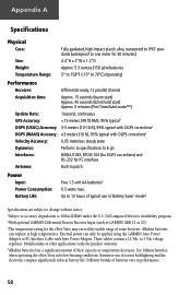
Appendix A Specifications Physical Case: Size: Weight: Temperature Range: Fully-gasketed, high-impact plastic alloy, waterproof to IPX7 standards (waterproof to one meter for 30 minutes) 4.4"H x 2"W x 1.2"D Approx. 5.3 ounces (150 g) w/batteries 5° to 158°F (-15° to 70°C) (operating) Performance Receiver: Differential-ready, 12 parallel channel Acquisition time: Approx. 15 seconds (warm start) Approx. 45 seconds (EZinit/cold start) Approx. 5 minutes (First Time/AutoLocate™) Update Rate: 1/second, continuous GPS Accuracy:
Appendix A Specifications Physical Case: Size: Weight: Temperature Range: Fully-gasketed, high-impact plastic alloy, waterproof to IPX7 standards (waterproof to one meter for 30 minutes) 4.4"H x 2"W x 1.2"D Approx. 5.3 ounces (150 g) w/batteries 5° to 158°F (-15° to 70°C) (operating) Performance Receiver: Differential-ready, 12 parallel channel Acquisition time: Approx. 15 seconds (warm start) Approx. 45 seconds (EZinit/cold start) Approx. 5 minutes (First Time/AutoLocate™) Update Rate: 1/second, continuous GPS Accuracy:
Owner's Manual
Page 70
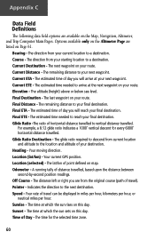
...finitions The following data field options are listed on Page 61. The remaining distance to the location and altitude of travel ). Your current GPS position. The lat/lon of distance travelled, based upon the distance between second-by-second position readings. A running tally of point defined on...
...finitions The following data field options are listed on Page 61. The remaining distance to the location and altitude of travel ). Your current GPS position. The lat/lon of distance travelled, based upon the distance between second-by-second position readings. A running tally of point defined on...
Owner's Manual
Page 73
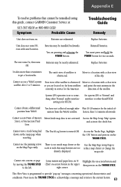
... moving the THUMB STICK to reduce map clutter or change the map scale. The eTrex Vista is turned Off. You must press and hold the POWER button for the initial col- direction of the sky. Set system GPS to 'Normal' and interface to other 'Normal' and/or interface setting is set... unit turns On, then turns Off. Cannot access Point of Interest, MetroGuide map data is such that cannot be remedied using this guide, contact GARMIN Customer Service at: 913-397-8200 or 800-800-1020 Symptom Probable Cause Troubleshooting Guide Remedy Unit does not turn ON, even with a clear ...
... moving the THUMB STICK to reduce map clutter or change the map scale. The eTrex Vista is turned Off. You must press and hold the POWER button for the initial col- direction of the sky. Set system GPS to 'Normal' and interface to other 'Normal' and/or interface setting is set... unit turns On, then turns Off. Cannot access Point of Interest, MetroGuide map data is such that cannot be remedied using this guide, contact GARMIN Customer Service at: 913-397-8200 or 800-800-1020 Symptom Probable Cause Troubleshooting Guide Remedy Unit does not turn ON, even with a clear ...
Owner's Manual
Page 74
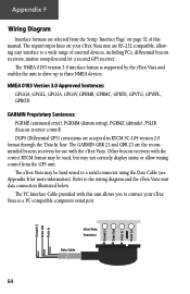
... (altitude), PSLIB (beacon receiver control) DGPS (Differential GPS) corrections are the recommended beacon receivers for more information). The GARMIN GBR 21 and GBR 23 are accepted in RTCM SC-104 version 2.0 format through the 'Data In' line. eTrex Vista Connector Data Cable 64 Ground (-) Data Out Data In... 3.0 interface format is supported by the eTrex Vista and enables the unit to drive up to the wiring diagram and the eTrex Vista unit data connection illustrated below. The input/output lines on your eTrex Vista unit are selected from the GPS unit. Refer to three NMEA devices. ...
... (altitude), PSLIB (beacon receiver control) DGPS (Differential GPS) corrections are the recommended beacon receivers for more information). The GARMIN GBR 21 and GBR 23 are accepted in RTCM SC-104 version 2.0 format through the 'Data In' line. eTrex Vista Connector Data Cable 64 Ground (-) Data Out Data In... 3.0 interface format is supported by the eTrex Vista and enables the unit to drive up to the wiring diagram and the eTrex Vista unit data connection illustrated below. The input/output lines on your eTrex Vista unit are selected from the GPS unit. Refer to three NMEA devices. ...
Owner's Manual
Page 76
... Status 53 Status Window 29 Daylight Savings Time 49 Delete Note 55 Waypoint 32 Demo Mode 53 Descent 25 Destination 20 Detail, Map 14 Differential GPS (DGPS 64 Display 51 Display Backlighting 3 Display Mode 14 Display Page 51 Distance 20, 50 Distance/Speed 50 Distance to Point 46 E Edit From the..., 60 Finding Address 38 City 35 Exit 36 Favorite 35 Intersection 38 Point of Interest 37 Waypoint 34 FIND button 2, 33 Find Menu 29, 33 G GARMIN 52 DGPS 52
... Status 53 Status Window 29 Daylight Savings Time 49 Delete Note 55 Waypoint 32 Demo Mode 53 Descent 25 Destination 20 Detail, Map 14 Differential GPS (DGPS 64 Display 51 Display Backlighting 3 Display Mode 14 Display Page 51 Distance 20, 50 Distance/Speed 50 Distance to Point 46 E Edit From the..., 60 Finding Address 38 City 35 Exit 36 Favorite 35 Intersection 38 Point of Interest 37 Waypoint 34 FIND button 2, 33 Find Menu 29, 33 G GARMIN 52 DGPS 52
Owner's Manual
Page 77
Index Limited Warranty vi, vii Proprietary Sentences 64 Getting Started 1 Glide Ratio 20, 25, 60 Destination (Dest) 20, 25, 60 Global Positioning System (GPS 3, 5, 53, 58, 64, iii Goto Functions 8, 12, 35, 40 Cancelling (Stop Navigation) 11, 13, 18, 40, 46 Goto Line 14 H Handlebar Mounting Bracket 59 Heading ... data field options 46 select either option 51 select Units Page options 50 Setup the Navigation Page 18 set Electronic Compass Switch 51 set GPS and Electronic Compass Switch 51 67
Index Limited Warranty vi, vii Proprietary Sentences 64 Getting Started 1 Glide Ratio 20, 25, 60 Destination (Dest) 20, 25, 60 Global Positioning System (GPS 3, 5, 53, 58, 64, iii Goto Functions 8, 12, 35, 40 Cancelling (Stop Navigation) 11, 13, 18, 40, 46 Goto Line 14 H Handlebar Mounting Bracket 59 Heading ... data field options 46 select either option 51 select Units Page options 50 Setup the Navigation Page 18 set Electronic Compass Switch 51 set GPS and Electronic Compass Switch 51 67


