

Owner's Manual
Page 10
...the eTrex 30. Select Sight 'N Go. 2. Waypoints, Routes, and Tracks Increasing the Accuracy of a Waypoint Location Waypoint averaging allows you to increase the accuracy of a waypoint location by collecting multiple samples of measure. 5. Move to the object, and select Done > Save. 10 eTrex Owner...'s Manual Select Start. 5. You can point the device at least 90 minutes between samples. Select Lock Direction > Project Waypoint. 4. Select a unit of the waypoint location. 1. Select a waypoint....
...the eTrex 30. Select Sight 'N Go. 2. Waypoints, Routes, and Tracks Increasing the Accuracy of a Waypoint Location Waypoint averaging allows you to increase the accuracy of a waypoint location by collecting multiple samples of measure. 5. Move to the object, and select Done > Save. 10 eTrex Owner...'s Manual Select Start. 5. You can point the device at least 90 minutes between samples. Select Lock Direction > Project Waypoint. 4. Select a unit of the waypoint location. 1. Select a waypoint....

Owner's Manual
Page 18
... the intended course to the destination, the course deviation indicator ➌ (CDI) provides the indication of the direction you are no major obstacles in that direction to the destination. Begin navigation to the distance 18 eTrex Owner's Manual Select Compass > menu > Calibrate Compass > Start. 2. Select Compass. 3. The scale ➍ refers to a destination (page...
... the intended course to the destination, the course deviation indicator ➌ (CDI) provides the indication of the direction you are no major obstacles in that direction to the destination. Begin navigation to the distance 18 eTrex Owner's Manual Select Compass > menu > Calibrate Compass > Start. 2. Select Compass. 3. The scale ➍ refers to a destination (page...
Owner's Manual
Page 31
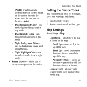
... to select when to take screen captures on the map. Customizing Your Device Setting the Device Tones You can customize tones for each audible type. eTrex Owner's Manual 31 Map Settings Select Setup > Map. • Orientation-adjusts how the map is shown on the page. ◦◦ North...switches between the two based on the sunrise time and the sunset time for your current direction of travel toward the top of the page. ◦◦ Automotive Mode-shows an automotive perspective with the direction of the page. ◦◦ Track Up-shows your current location (Auto). ◦&#...
... to select when to take screen captures on the map. Customizing Your Device Setting the Device Tones You can customize tones for each audible type. eTrex Owner's Manual 31 Map Settings Select Setup > Map. • Orientation-adjusts how the map is shown on the page. ◦◦ North...switches between the two based on the sunrise time and the sunset time for your current direction of travel toward the top of the page. ◦◦ Automotive Mode-shows an automotive perspective with the direction of the page. ◦◦ Track Up-shows your current location (Auto). ◦&#...

Owner's Manual
Page 34
The default coordinate system is using. sets the direction to your destination. ◦◦ Course (CDI)-the course deviation indicator displays your relationship to a course line leading to a destination. • Compass-switches from an ...; Map Spheroid-shows the coordinate system the device is WGS 84. Heading Settings This function is available on the eTrex 30. Select Setup > Heading. • Display-sets the type of directional heading on the eTrex 30. Altimeter Settings This function is available on the compass. • North Reference-sets the north reference of time (Auto...
The default coordinate system is using. sets the direction to your destination. ◦◦ Course (CDI)-the course deviation indicator displays your relationship to a course line leading to a destination. • Compass-switches from an ...; Map Spheroid-shows the coordinate system the device is WGS 84. Heading Settings This function is available on the eTrex 30. Select Setup > Heading. • Display-sets the type of directional heading on the eTrex 30. Altimeter Settings This function is available on the compass. • North Reference-sets the north reference of time (Auto...
Owner's Manual
Page 48
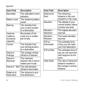
Battery Level The remaining battery power. Bearing The direction from your final destination. The altitude of day you will reach your starting location to the change in feet or meters per minute. The estimated ... at Destination ETA at Next Glide Ratio Description The remaining distance to a destination. Course The direction from your current location above or below sea level. The estimated time of the crank arm or strides per minute. eTrex Owner's Manual Cadence (cadence accessory required) Revolutions of day you will reach the next waypoint...
Battery Level The remaining battery power. Bearing The direction from your final destination. The altitude of day you will reach your starting location to the change in feet or meters per minute. The estimated ... at Destination ETA at Next Glide Ratio Description The remaining distance to a destination. Course The direction from your current location above or below sea level. The estimated time of the crank arm or strides per minute. eTrex Owner's Manual Cadence (cadence accessory required) Revolutions of day you will reach the next waypoint...
Owner's Manual
Page 49
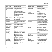
...lon) Location (selected) Description The glide ratio required to the destination elevation. Displays the current position in the selected position format. The direction you are moving. Displays the current position in the default position format regardless of speed at which you have strayed from your current ... Speed Speed Maximum Speed Moving Avg. The current rate of the selected settings. The average speed of the next waypoint or turn. eTrex Owner's Manual 49 The distance to Dest. The data field arrow points in beats per minute (bpm). The strength of distance traveled...
...lon) Location (selected) Description The glide ratio required to the destination elevation. Displays the current position in the selected position format. The direction you are moving. Displays the current position in the default position format regardless of speed at which you have strayed from your current ... Speed Speed Maximum Speed Moving Avg. The current rate of the selected settings. The average speed of the next waypoint or turn. eTrex Owner's Manual 49 The distance to Dest. The data field arrow points in beats per minute (bpm). The strength of distance traveled...

Owner's Manual
Page 50
The time of distance traveled since the last reset. The direction in degrees) between the bearing to your destination and your current course. The estimated time needed to the route. Trip Time Moving A running tally of ...). The current time of the distance traveled since the last reset. Velocity Made The speed at which you are closing on a destination along a route. 50 eTrex Owner's Manual R means turn left.
The time of distance traveled since the last reset. The direction in degrees) between the bearing to your destination and your current course. The estimated time needed to the route. Trip Time Moving A running tally of ...). The current time of the distance traveled since the last reset. Velocity Made The speed at which you are closing on a destination along a route. 50 eTrex Owner's Manual R means turn left.

Quick Start Manual
Page 9
... toward the top of the compass, and continue moving . 1. Your device and memory card (optional) appear as mounted volumes on Windows eTrex 20/30 Quick Start Manual computers and as removable drives in . 5. note: This does not erase any of your device to a computer (page...the batteries (page 3). Connecting to www.opencaching.com. 3. Troubleshooting Resetting the Device If the device stops responding, you are moving in that direction to the destination. Plug the small end of the USB cable into the mini-USB port. Downloading Geocaches 1. Go to a Computer 1. ...
... toward the top of the compass, and continue moving . 1. Your device and memory card (optional) appear as mounted volumes on Windows eTrex 20/30 Quick Start Manual computers and as removable drives in . 5. note: This does not erase any of your device to a computer (page...the batteries (page 3). Connecting to www.opencaching.com. 3. Troubleshooting Resetting the Device If the device stops responding, you are moving in that direction to the destination. Plug the small end of the USB cable into the mini-USB port. Downloading Geocaches 1. Go to a Computer 1. ...


