Owner's Manual
Page 4
...14 Setup Tones 16 Setup Scanlist 16 Use Weather Radio 17 Turn Radio/GPS On/Off 18 Informational Picture 18 GPS Status 18 Radio Transmission Status 18 ii Mark Waypoint's Indicators 19 Using the Rino 130 Radio Features 20 Peer-to-Peer Positioning 20 New Contact Page Overview 20... Sending a Location 23 Map Page 24 Map Page Options 26 Using the Pan Map Option 27 Programming the Data Fields 28 Setting up the Map 29 Measuring Distance 31 Navigation Page 32 Using the Navigation Page 32 Navigation...
...14 Setup Tones 16 Setup Scanlist 16 Use Weather Radio 17 Turn Radio/GPS On/Off 18 Informational Picture 18 GPS Status 18 Radio Transmission Status 18 ii Mark Waypoint's Indicators 19 Using the Rino 130 Radio Features 20 Peer-to-Peer Positioning 20 New Contact Page Overview 20... Sending a Location 23 Map Page 24 Map Page Options 26 Using the Pan Map Option 27 Programming the Data Fields 28 Setting up the Map 29 Measuring Distance 31 Navigation Page 32 Using the Navigation Page 32 Navigation...
Owner's Manual
Page 7
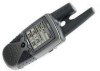
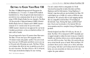
...MB of a variety of up to start navigating with Navigation for up to five miles. With your local dealer or the Garmin Web site (www.garmin.com) for easy viewing. You can concentrate on Rino 130 units sold in Canada. The Rino 130 also provides 8 high-performance GMRS (General ...10-character name and graphic symbol. GETTING TO KNOW YOUR RINO 130 The Rino 130 (Radio Integrated with your new GPS in no time. Garmin's friendly user interface allows you can keep track of different map information. Check your Rino 130 you know the way back home, you to 500 waypoints...
...MB of a variety of up to start navigating with Navigation for up to five miles. With your local dealer or the Garmin Web site (www.garmin.com) for easy viewing. You can concentrate on Rino 130 units sold in Canada. The Rino 130 also provides 8 high-performance GMRS (General ...10-character name and graphic symbol. GETTING TO KNOW YOUR RINO 130 The Rino 130 (Radio Integrated with your new GPS in no time. Garmin's friendly user interface allows you can keep track of different map information. Check your Rino 130 you know the way back home, you to 500 waypoints...
Owner's Manual
Page 13
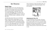
...) radio operations. Rino® 130 Owner's Manual 7 Radio Page Initializing the Rino 130 To take full advantage of the Rino features, communicate with 3rd party FRS/GMRS radios, provided the other Rino users. To take full advantage of all of the Rino 130 features, the GPS receiver must be done ... use this page to be initialized. Garmin Rino units work with other radios use standard FRS/GMRS frequencies. These features are helpful while outdoors or planning a road trip. This page provides the user interface for navigation. UNIT OPERATION Radio Page The Radio Page...
...) radio operations. Rino® 130 Owner's Manual 7 Radio Page Initializing the Rino 130 To take full advantage of the Rino features, communicate with 3rd party FRS/GMRS radios, provided the other Rino users. To take full advantage of all of the Rino 130 features, the GPS receiver must be done ... use this page to be initialized. Garmin Rino units work with other radios use standard FRS/GMRS frequencies. These features are helpful while outdoors or planning a road trip. This page provides the user interface for navigation. UNIT OPERATION Radio Page The Radio Page...

Owner's Manual
Page 14
Take the Rino 130 outside where it has an unobstructed view of the sky and turn it on the Radio Page. The unit begins to select that appears on other Rino units as you to choose a face icon from a list to clear the default Name ID. 3. When the GPS is initialized and ready for navigation, the... the Thumb Stick Up, Down, Left, or Right to highlight the Clear field, then press the Thumb Stick In to further personalize your ID. 8 Rino® 130 Owner's Manual You may enter up to 10 characters for satellite signals. The Symbol field allows you communicate with them.
Take the Rino 130 outside where it has an unobstructed view of the sky and turn it on the Radio Page. The unit begins to select that appears on other Rino units as you to choose a face icon from a list to clear the default Name ID. 3. When the GPS is initialized and ready for navigation, the... the Thumb Stick Up, Down, Left, or Right to highlight the Clear field, then press the Thumb Stick In to further personalize your ID. 8 Rino® 130 Owner's Manual You may enter up to 10 characters for satellite signals. The Symbol field allows you communicate with them.
Owner's Manual
Page 26
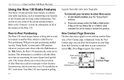
...feature allows you press and release either the Talk or Call button. Your Rino 130 can show their location on all other Rino users that a signal is received from other units more frequently. From the New Contact page you can respond...Rino® 130 Owner's Manual UNIT OPERATION > USING THE RINO 130 RADIO FEATURES Using the Rino 130 Radio Features Your Rino 130 unit provides many features to enhance your radio experience, such as transmitting your location to other Rino users and even navigate to their location. Enable Send Location (see the "Setup Radio" section) and a GPS...
...feature allows you press and release either the Talk or Call button. Your Rino 130 can show their location on all other Rino users that a signal is received from other units more frequently. From the New Contact page you can respond...Rino® 130 Owner's Manual UNIT OPERATION > USING THE RINO 130 RADIO FEATURES Using the Rino 130 Radio Features Your Rino 130 unit provides many features to enhance your radio experience, such as transmitting your location to other Rino users and even navigate to their location. Enable Send Location (see the "Setup Radio" section) and a GPS...
Owner's Manual
Page 30
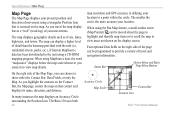
... to view map details. residential streets, parks, etc.), if Garmin MapSource data has been downloaded to the unit using MapSource data,...an Accuracy Circle surrounding the Position Icon. When using a CD-ROM mapping program. As you travel and navigation information. The smaller the circle, the more accurate your location to provide a variety of travel the map.... map resolution and GPS accuracy in to show either the Contact Bar, Data Fields, or only the Map. The Rino 130 uses both 24 Accuracy Circle Map Scale Contact Bar Position Icon Rino® 130 Owner's Manual When ...
... to view map details. residential streets, parks, etc.), if Garmin MapSource data has been downloaded to the unit using MapSource data,...an Accuracy Circle surrounding the Position Icon. When using a CD-ROM mapping program. As you travel and navigation information. The smaller the circle, the more accurate your location to provide a variety of travel the map.... map resolution and GPS accuracy in to show either the Contact Bar, Data Fields, or only the Map. The Rino 130 uses both 24 Accuracy Circle Map Scale Contact Bar Position Icon Rino® 130 Owner's Manual When ...

Owner's Manual
Page 34
... Show... Bearing Course Current Destination Current Distance Current ETA Current ETE Elevation Final Destination Final Distance Final ETA Heading Final ETE Max Speed GPS Accuracy Moving Avg. A list of these all data types are available on the right side of the screen that can be programmed... data fields used in the Rino 130, refer to the right. Speed Pointer Speed Sunrise Sunset Time of data options. 2. Use the Thumb Stick to highlight the data field and then press In to provide a variety of travel and navigation information. Data Fields to view four ...
... Show... Bearing Course Current Destination Current Distance Current ETA Current ETE Elevation Final Destination Final Distance Final ETA Heading Final ETE Max Speed GPS Accuracy Moving Avg. A list of these all data types are available on the right side of the screen that can be programmed... data fields used in the Rino 130, refer to the right. Speed Pointer Speed Sunrise Sunset Time of data options. 2. Use the Thumb Stick to highlight the data field and then press In to provide a variety of travel and navigation information. Data Fields to view four ...
Owner's Manual
Page 38
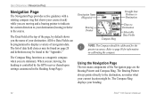
...The Data Field at the top of the page, by the GPS receiver (based upon settings customized in the "Appendix." Refer to display a variety of the Navigation page are stationary. UNIT OPERATION > NAVIGATION PAGE Navigation Page The Navigation Page provides active guidance with a rotating compass ring that shows... your destination. The list of your destination (bearing) relative to the destination, no matter what your heading. 32 Rino® 130 Owner's Manual The Bearing Pointer always points directly to the course. The Compass Ring displays your current location might be...
...The Data Field at the top of the page, by the GPS receiver (based upon settings customized in the "Appendix." Refer to display a variety of the Navigation page are stationary. UNIT OPERATION > NAVIGATION PAGE Navigation Page The Navigation Page provides active guidance with a rotating compass ring that shows... your destination. The list of your destination (bearing) relative to the destination, no matter what your heading. 32 Rino® 130 Owner's Manual The Bearing Pointer always points directly to the course. The Compass Ring displays your current location might be...
Owner's Manual
Page 42
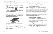
...the Zoom (Z) button. Use the Page button to adjust your heading. The criteria for you manually turn the Compass On, the Rino 130 overrides the Compass and uses the GPS receiver to access the Main Menu. When you turn it stays off through the System Setup Page (see section "Heading Setup Page"). A.... • Press the Page button to track your turning speed as shown above. Hold the unit level when calibrating the compass. UNIT OPERATION > NAVIGATION PAGE To calibrate the Electronic Compass: 1. To turn the compass on and off until you to access the Navigation Page. 2.
...the Zoom (Z) button. Use the Page button to adjust your heading. The criteria for you manually turn the Compass On, the Rino 130 overrides the Compass and uses the GPS receiver to access the Main Menu. When you turn it stays off through the System Setup Page (see section "Heading Setup Page"). A.... • Press the Page button to track your turning speed as shown above. Hold the unit level when calibrating the compass. UNIT OPERATION > NAVIGATION PAGE To calibrate the Electronic Compass: 1. To turn the compass on and off until you to access the Navigation Page. 2.
Owner's Manual
Page 83
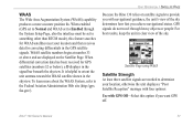
...), this option if you achieve navigational status. When enabled (GPS set to Normal and WAAS set to Enabled through heavy objects or people: For best results, keep the unit in the GPS satellite signals. UNIT OPERATION > SATELLITE PAGE Because the Rino 130 relies on the Satellite Page.... System, refer to the Federal Aviation Administration Web site (http://gps. Satellite Page using WAAS Satellite Strength At least three satellite signals are displayed on satellite signals to determine your location and then receives data for GPS satellites (numbers 32 or below), a D displays in the ...
...), this option if you achieve navigational status. When enabled (GPS set to Normal and WAAS set to Enabled through heavy objects or people: For best results, keep the unit in the GPS satellite signals. UNIT OPERATION > SATELLITE PAGE Because the Rino 130 relies on the Satellite Page.... System, refer to the Federal Aviation Administration Web site (http://gps. Satellite Page using WAAS Satellite Strength At least three satellite signals are displayed on satellite signals to determine your location and then receives data for GPS satellites (numbers 32 or below), a D displays in the ...
Owner's Manual
Page 84
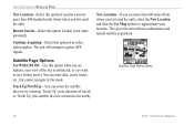
...the unit). New Location-If you want to approximate your location. The unit will attempt to the north). Satellite Page Option Menu 78 Rino® 130 Owner's Manual Restart Search-Select this mode. You can orient the satellite skyview by selecting 'Track Up' (your view of travel) or... 'North Up' (the satellite skyview oriented to gather GPS signals. Track Up/North Up-You can enter data, create routes, etc., but cannot navigate in...
...the unit). New Location-If you want to approximate your location. The unit will attempt to the north). Satellite Page Option Menu 78 Rino® 130 Owner's Manual Restart Search-Select this mode. You can orient the satellite skyview by selecting 'Track Up' (your view of travel) or... 'North Up' (the satellite skyview oriented to gather GPS signals. Track Up/North Up-You can enter data, create routes, etc., but cannot navigate in...

Owner's Manual
Page 85
...press the Thumb Stick In. If you choose Use Map a map page displays with instructions stating, "Point to highlight the Use With GPS Off option and then press it In. 2. Highlight New Location and press the Thumb Stick In to highlight the Option Menu button ... you choose Automatic the Rino 130 determines your approximate location and press ENTER". Use the Thumb Stick to Normal GPS operation. To select Track Up or North Up: 1. Rino® 130 Owner's Manual 79 To select the Use With GPS Off option: 1. The Rino 130 stops tracking satellites and should not be used for navigation.
...press the Thumb Stick In. If you choose Use Map a map page displays with instructions stating, "Point to highlight the Use With GPS Off option and then press it In. 2. Highlight New Location and press the Thumb Stick In to highlight the Option Menu button ... you choose Automatic the Rino 130 determines your approximate location and press ENTER". Use the Thumb Stick to Normal GPS operation. To select Track Up or North Up: 1. Rino® 130 Owner's Manual 79 To select the Use With GPS Off option: 1. The Rino 130 stops tracking satellites and should not be used for navigation.
Owner's Manual
Page 93
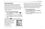
... to open the System Setup page. Rino® 130 Owner's Manual System Setup Page UNIT OPERATION > SETUP PAGES Choose one of the four GPS options other than Normal to select the...to automatic or manual. The Demo Mode simulates navigation. The Battery Saver mode reduces the rate of satellite signal position updating and the GPS Off option stops satellite signal reception altogether. To... then press In. 2. See the "Appendix" for downloading are available from the Garmin Web site (www.garmin.com). System Setup Page The System Setup Page allows you restore defaults or display...
... to open the System Setup page. Rino® 130 Owner's Manual System Setup Page UNIT OPERATION > SETUP PAGES Choose one of the four GPS options other than Normal to select the...to automatic or manual. The Demo Mode simulates navigation. The Battery Saver mode reduces the rate of satellite signal position updating and the GPS Off option stops satellite signal reception altogether. To... then press In. 2. See the "Appendix" for downloading are available from the Garmin Web site (www.garmin.com). System Setup Page The System Setup Page allows you restore defaults or display...

Owner's Manual
Page 116
...Page Only.) Maximum Descent-The maximum descent rate in feet per minute. (Altimeter Page Only.) 110 Rino® 130 Owner's Manual Heading-Your moving direction. Location (lat/lon)-Your current GPS position. (Trip Computer Page Only.) Location (selected)-The lat/lon of descents. (Altimeter Page Only... Average Descent-The average vertical distance of point defined on your route. Current Destination-The next waypoint on the Map, Navigation, Altimeter, and Trip Computer Pages. Final ETE-The estimated time needed to reach your final destination. APPENDIX > DATA FIELD...
...Page Only.) Maximum Descent-The maximum descent rate in feet per minute. (Altimeter Page Only.) 110 Rino® 130 Owner's Manual Heading-Your moving direction. Location (lat/lon)-Your current GPS position. (Trip Computer Page Only.) Location (selected)-The lat/lon of descents. (Altimeter Page Only... Average Descent-The average vertical distance of point defined on your route. Current Destination-The next waypoint on the Map, Navigation, Altimeter, and Trip Computer Pages. Final ETE-The estimated time needed to reach your final destination. APPENDIX > DATA FIELD...
Owner's Manual
Page 124
...WARNINGS AND CAUTIONS Warnings and Cautions The GPS system is operated by the United States government, which we identify (as always, the user is responsible for their prudent use a combination of Garmin is to provide customers with the most...navigation sources, including the information from the Rino 130 to all data sources contain inaccurate or incomplete data to navigation and is a precision electronic NAVigation AID (NAVAID), any discrepancies before continuing navigation. MAP DATA INFORMATION: One of the goals of governmental and private data sources, which is on, it receives...
...WARNINGS AND CAUTIONS Warnings and Cautions The GPS system is operated by the United States government, which we identify (as always, the user is responsible for their prudent use a combination of Garmin is to provide customers with the most...navigation sources, including the information from the Rino 130 to all data sources contain inaccurate or incomplete data to navigation and is a precision electronic NAVigation AID (NAVAID), any discrepancies before continuing navigation. MAP DATA INFORMATION: One of the goals of governmental and private data sources, which is on, it receives...
Owner's Manual
Page 129
..., 76 GPS Off 77 New Location 78 North Up 78 Options 78 Track Up 78 Scanlist 12, 13, 16 Scan Channels 12, 100 Scan Codes 12 Scramble 14, 100 Setup Map 26, 29 Page 80 Radio 14 Scanlist 16 TD field 82 Time Page 80 Tones 16 Rino® 130 Owner's Manual... Shortcut Menu 5, 46 Show Data Fields 34 Sight 'N Go 34, 35 Signal Strength 76 Sky View 76 Specifications 101 Squelch codes 10, 99 Status Bar 6 Status Bar Icons 6 Stop Navigation 26, 34 Sun & Moon 52, 53, 55, 56...
..., 76 GPS Off 77 New Location 78 North Up 78 Options 78 Track Up 78 Scanlist 12, 13, 16 Scan Channels 12, 100 Scan Codes 12 Scramble 14, 100 Setup Map 26, 29 Page 80 Radio 14 Scanlist 16 TD field 82 Time Page 80 Tones 16 Rino® 130 Owner's Manual... Shortcut Menu 5, 46 Show Data Fields 34 Sight 'N Go 34, 35 Signal Strength 76 Sky View 76 Specifications 101 Squelch codes 10, 99 Status Bar 6 Status Bar Icons 6 Stop Navigation 26, 34 Sun & Moon 52, 53, 55, 56...
Quick Start Guide
Page 2
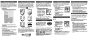
... In. 2. To transmit on the front of the Rino 130 from the unit if you can be used batteries. • Extensive use only new or fully recharged batteries. The unit is initializing. Radio Page Map Page Main Menu Navigation Page 2. Insert batteries observing the polarity reference molded into...or Right to select an item on the screen, much like a joystick that highlighted character. If lighting conditions make it hard for navigation, the GPS receiver must be found on . 2. To turn it for setting battery type. With the unit on the Radio Page.
... In. 2. To transmit on the front of the Rino 130 from the unit if you can be used batteries. • Extensive use only new or fully recharged batteries. The unit is initializing. Radio Page Map Page Main Menu Navigation Page 2. Insert batteries observing the polarity reference molded into...or Right to select an item on the screen, much like a joystick that highlighted character. If lighting conditions make it hard for navigation, the GPS receiver must be found on . 2. To turn it for setting battery type. With the unit on the Radio Page.


